Embarking on the 646.3-mile journey from Chula Vista to Susanville is a significant undertaking that spans the length of California. With an estimated driving time of 13 hours, this trek is best approached as a two-day excursion rather than a grueling single-day haul. You will navigate a combination of the Grand Army of the Republic Highway, the Blue Star Memorial Highway, and I-580 throughout the trip. Budgeting approximately $150 for fuel is a smart move to keep your finances in check before you hit the road. Because you are traversing the state from one end to the other, you should prepare for a long-distance drive that demands stamina and careful time management. Splitting the drive allows you to arrive in Susanville refreshed rather than exhausted.
Trip Pace
Best split across 2 days
Treat the return leg as its own travel day rather than an afterthought.
Break Rhythm
3 planned breaks
Plan on a short reset every 3 to 4 hours to stay fresh behind the wheel.
Midpoint
323.1 miles from Chula Vista, CA
A natural place for your longest stop of the day
, about 6h 20m into the drive
.
Main Roads
Road
Distance
Duration
Grand Army of the Republic Highway
104.5 mi
2h 2m
Blue Star Memorial Highway
103.3 mi
2h 3m
I 580
101.1 mi
1h 55m
North Sierra Highway
87.4 mi
1h 44m
Escondido Freeway
65.3 mi
1h 13m
Route 395
43.3 mi
56m
Avocado Highway
21.9 mi
23m
Main Street
19.3 mi
26m
Longest stretch:
Grand Army of the Republic Highway
— 104.5 mi, about 2h 2m
Traffic on I-15
Hour-of-day weekday pattern from 45 FHWA count stations on your route.
Peak
2 PM
~6,893 veh/hr typical
Quietest
1 AM
~839 veh/hr
Peak-to-quiet ratio
8.2×
busier at peak than in the quiet hours
12a6anoon6p11p
Averaged across 52 weeks of 2023 FHWA Travel Monitoring Analysis System data. Weekday hours only (Mon–Fri).
Turn-by-Turn Driving Directions
Step-by-step road directions between Chula Vista, CA and Susanville, CA.
1
Start on F Street
52 ft·3 sec·F Street
2
Turn left onto 4th Avenue
0.9 mi·1 min·4th Avenue
Use the left lane.
3
Continue on Highland Avenue
478 ft·10 sec·Highland Avenue
4
Take the ramp
0.2 mi·24 sec
Toward CA 54 EastUse the right lane.
5
Merge onto CA 54
0.3 mi·19 sec·South Bay Freeway
6
Take the exit
0.2 mi·23 sec
Exit 2Toward I 805Use the straight / slight right lanes.
7
Keep slight left at fork
0.8 mi·1 min
Toward I 805 NorthUse the straight / slight right lanes.
8
Merge onto I 805
4.9 mi·5 min·Jacob Dekema Freeway
Use the straight / slight right lanes.
9
Take the exit
0.9 mi·1 min
Exit 14Toward CA 15 NorthUse the straight / slight right lanes.
10
Merge onto CA 15
7.9 mi·8 min·Escondido Freeway
Use the straight / slight right lanes.
11
Keep slight right at fork onto I 15
0.8 mi·54 sec·Escondido Freeway
12
Continue on I 15
1.8 mi·2 min·Semper Fi Highway
Use the slight right lane.
13
Continue on I 15
3.1 mi·3 min·Escondido Freeway
Use the straight / slight right lanes.
14
Continue on I 15
4.6 mi·5 min·Tony Gwynn Memorial Freeway
Use the straight / slight right lanes.
15
Continue on I 15
5.9 mi·6 min·Escondido Freeway
Use the straight / slight right lanes.
16
Keep slight left at fork onto I 15
6.9 mi·7 min·Escondido Freeway
Use the straight / slight right lanes.
17
Continue on I 15
22 mi·23 min·Avocado Highway
Use the straight / slight right lanes.
18
Continue on I 15
6.3 mi·6 min·Escondido Freeway
Use the straight / slight right lanes.
19
Take the exit
0.3 mi·18 sec
Exit 63Toward I 215Use the straight / slight right lanes.
20
Continue on I 215
34 mi·40 min·Escondido Freeway
Toward I 215Use the straight / slight right lanes.
21
Keep slight right at fork onto I 215
0.5 mi·51 sec·I 215
Toward I 215 North: San Bernardino, BarstowUse the slight right lane.
22
Merge onto I 215
5.4 mi·6 min·Riverside Freeway
Use the straight / slight right lanes.
23
Continue on I 215
5.5 mi·6 min·San Bernardino Freeway
Use the straight / slight right lanes.
24
Continue on I 215
8.9 mi·9 min·Barstow Freeway
Use the straight / slight right lanes.
25
Keep slight left at fork
0.2 mi·13 sec
26
Continue on I 15
6.8 mi·7 min·Barstow and Mojave Freeway
Use the straight / slight right lanes.
27
Continue on I 15; US 66 Hist; US 91 Hist; US 395 Hist
5.4 mi·5 min·CHP Officer Larry L. Wetterling and San Bernardino County Sheriff's Lieutenant Alfred E. Stewart Memorial Highway
Use the straight / slight right lanes.
28
Continue on I 15; US 66 Hist
2.8 mi·3 min·Barstow and Mojave Freeway
Use the straight / slight right lanes.
29
Take the exit
0.3 mi·37 sec
Exit 141Toward US 395 North: Adelanto, Bishop
30
Continue on this road
0.9 mi·1 min·this road
Exit 141Toward US 395 North: Adelanto, Bishop
31
Continue on US 395
67 mi·1 hr 20 min·Blue Star Memorial Highway
Use the straight / right lanes.
32
Continue on US 395
0.9 mi·1 min·Red Mountain Road
33
Continue on US 395
37 mi·42 min·Blue Star Memorial Highway
Use the straight lane.
34
Continue on US 395; US 6 Hist
56 mi·1 hr 4 min·Grand Army of the Republic Highway
Use the straight lane.
35
Continue on US 395; US 6 Hist
2.2 mi·4 min·South Main Street
36
Continue on US 395; US 6 Hist
15 mi·17 min·Grand Army of the Republic Highway
Use the straight lane.
37
Continue on US 395; US 6 Hist
0.7 mi·1 min·South Edwards Street
38
Continue on US 395; US 6 Hist
26 mi·31 min·Grand Army of the Republic Highway
Use the straight lane.
39
Continue on US 395; US 6 Hist
0.2 mi·32 sec·North Main Street
40
Continue on US 395; US 6 Hist
7.4 mi·8 min·Grand Army of the Republic Highway
41
Continue on US 395; CA 168; US 6 Hist
5.0 mi·5 min·El Camino Sierra
Use the straight lane.
42
Continue on US 395; CA 168; US 6 Hist
2.4 mi·4 min·South Main Street
Use the straight lane.
43
Turn left onto CA 168
1.5 mi·2 min·West Line Street
Use the left lane.
44
Turn right onto North Barlow Lane
1.0 mi·1 min·North Barlow Lane
45
Turn left onto US 395
87 mi·1 hr 44 min·North Sierra Highway
Use the straight lane.
46
Turn right onto Sinclair Street
0.1 mi·12 sec·Sinclair Street
47
Turn left onto Emigrant Street
0.5 mi·40 sec·Emigrant Street
48
Continue on US 395
43 mi·56 min·Route 395
Use the left lane.
49
Continue on US 395
19 mi·26 min·Main Street
50
Continue on US 395
2.9 mi·7 min·US 395
51
Turn left onto County Road
1.1 mi·1 min·County Road
52
Enter roundabout onto NV 88
2 ft·0 sec·Woodfords Road
53
Continue on NV 88
0.4 mi·48 sec·Woodfords Road
54
Turn left onto US 395
11 mi·13 min·US 395
Use the straight / right lanes.
55
Take the exit onto US 395
0.9 mi·1 min·US 395
Toward I 580 North, US 395 North, US 50 East: Reno, Dayton, FallonUse the straight / slight right lanes.
56
Merge onto I 580; US 50; US 395
13 mi·14 min·Carson City Deputy Sheriff Carl Howell Memorial Freeway
57
Continue on I 580; US 395
101 mi·1 hr 55 min·I 580; US 395
58
Continue on CA 36
4.3 mi·7 min·CA 36
Use the straight / right lanes.
59
Turn left onto Foss Street
61 ft·2 sec·Foss Street
60
Arrive at destination
Foss Street
Trip Plan
To make this 13-hour trek manageable, plan for at least three dedicated stops to stretch your legs and refuel. Since you are covering such a vast distance, departing early in the morning is essential to avoid potential traffic congestion and ensure you reach your overnight destination before dark. Keep a close eye on your fuel gauge during that 104.5-mile stretch on the Grand Army of the Republic Highway, as services can be spaced out significantly. I recommend mapping out your midpoint stop in advance to help you balance your driving hours effectively over the two-day itinerary. By pacing yourself and respecting the distance, you can turn this long haul into a much more comfortable travel experience.
Morning Departure
Start early — leave by 6-7 AM to arrive at a reasonable hour.
Evening Departure
This is a long drive — plan for a morning departure or consider splitting it into two days.
This drive is better paced as a 2-day trip.
Plan roughly 3 meaningful breaks for fuel, food, and rest.
The halfway point lands around 323.1 miles from Chula Vista, CA, or about 6h 20m into the drive.
The longest continuous stretch on this route runs about 104.5 miles.
Consider an overnight stop or starting very early.
Departure
Before you leave
Start with fuel, water, and navigation already sorted so the first hour feels easy.
First stop
Around 142 miles or 2h 43m in
Use this first pause for coffee, a restroom break, and a quick traffic check ahead.
Halfway reset
Around 323.1 miles or 6h 20m in
This is the best place for your longest stop, a real meal, and a full fuel check.
Overnight split
Day 1 wrap after about 323.1 miles or 6h 20m
Stop before fatigue turns the last few hours into a grind. You want day two to start fresh, not just resumed.
Final approach
Final hour starts around 11h 48m
Traffic, exits, and arrival timing usually matter more near Susanville, CA than in the middle of the route.
Before You Leave
+
Open the route before leaving Chula Vista, CA so your first major turns are already loaded.
+
Leave with enough water and a charging cable within reach, not packed away.
+
Check your fuel range against the first long segment, especially if you are starting outside city service areas.
+
Pick one backup stop option before the midpoint in case traffic changes your pacing.
+
Treat this as a 2-day road trip and book the overnight stop before the busiest arrival window.
Day 1
Settle into the route from Chula Vista, CA
Aim for roughly 323 miles and 6.5 hours of wheel time on this day.
Day 2
Finish the approach into Susanville, CA
Aim for roughly 323 miles and 6.5 hours of wheel time on this day.
Your first comfortable stop window is around 142 miles from Chula Vista, CA.
This route usually feels better as a 2-day drive than as one long push.
Plan about 3 real breaks rather than only quick fuel stops.
The longest stretch is on Grand Army of the Republic Highway for about 104.5 miles.
Where to Stop
Rest stops, refuel points, and overnight suggestions along this route.
Place data sourced from public business listings. Hours and availability may vary.
Heads-up: tricky spots
5 of 28
5 decision points cluster between mile 1 and 102.3 — GPS handles the exact turns, but know they're coming. Your lane choice matters more than the turn itself.
7
1 mi into trip|~2m in
Take the ramp toward CA 54 East
Lane positioning matters here
Use the right lane.
Toward CA 54 East
8
1.5 mi into trip|~2m in
Take the exit toward I 805
Exit ramp - move to the correct lane early. Lane positioning matters here
Use the straight / slight right lanes.
Exit 2
Toward I 805
7
1.7 mi into trip|~3m in
Keep slight left at fork toward I 805 North
Highway fork - watch signs carefully. Lane positioning matters here
Use the straight / slight right lanes.
Toward I 805 North
7
7.5 mi into trip|~10m in
Take the exit toward CA 15 North
Exit ramp - move to the correct lane early. Lane positioning matters here
Use the straight / slight right lanes.
Exit 14
Toward CA 15 North
8
102.3 mi into trip|~1h 57m in|I 215
Keep slight right at fork onto I 215 toward I 215 North: San Bernardino, Barstow
Highway fork - watch signs carefully. Lane positioning matters here. Multiple destination signs - pick the right one
Use the slight right lane.
Toward I 215 North: San Bernardino, Barstow
Fuel & Cost
Regular Gas
$135.21 one way
$270.43 round trip
$5.31/gal25.4 MPG avg226 kg CO2
Fuel Type
$/gal
One Way
Round Trip
midgrade
$5.52
$140.43
$280.86
premium
$5.67
$144.15
$288.29
diesel
$4.80
$122.03
$244.07
No toll roads detected on this route.
Estimated Trip Cost (one way, 1 person)
Fuel
$135
Hotel (1n)
$80–$140
Meals
$50–$100
Total
$265–$375
Rough estimate based on US averages. Hotel $80–$140/night, meals $25–$50/day.
Estimated CO2 emission: 226.1 kg one way.
Prices: EIA weekly data, 2026-07-13.
Driving Electric?
About $68 in charging
· 2 stops
· 66% less CO2
Vehicle Type
kWh
Stops
DC Fast
Home Charge
Average EV
193.9
2
$67.86
$31.02
Efficient EV
161.6
1
$56.55
$25.85
EV Truck/SUV
258.5
3
$90.48
$41.36
Gas CO2
226 kg
EV CO2
76 kg (66% less)
Plan for 2 charging stops, roughly every 270 miles. Allow 25-40 minutes per stop at a DC fast charger.
DC fast charging avg $0.35/kWh. Home charging avg $0.16/kWh. US grid CO2: 0.39 kg/kWh.
Travel Intel
Current conditions at both ends of the drive.
Forecast as of Jul 16, 2026
Origin
Chula Vista, CA
Evening
in Chula Vista on Saturday
Local time
7:54 PM
PDT
Current temp
78°F
Sunny
SW 10 mph4% chanceLive forecast
Heat Advisory
Heat Advisory issued July 16 at 12:00PM PDT until July 16 at 11:00PM PDT by NWS Hanford CA
Red Flag Warning
Red Flag Warning issued July 16 at 11:39AM PDT until July 17 at 8:00PM PDT by NWS Medford OR
Destination
Susanville, CA
Evening
in Susanville on Saturday
Local time
7:54 PM
PDT
Current temp
92°F
Sunny
SW 10 to 15 mph0% chanceLive forecast
Heat Advisory
Heat Advisory issued July 16 at 12:00PM PDT until July 16 at 11:00PM PDT by NWS Hanford CA
Red Flag Warning
Red Flag Warning issued July 16 at 11:39AM PDT until July 17 at 8:00PM PDT by NWS Medford OR
Seasonal Notes
Summer travel usually means heavier construction, hotter rest stops, and busier weekend traffic around major cities.
Winter travel shortens daylight, so a route that looks manageable on paper can feel much longer after dark.
Holiday weekends tend to make both departure and arrival windows slower than the raw route time suggests.
For long drives, weather on day two can matter just as much as conditions at departure, so check the whole travel window rather than only the first day.
Time zone
Same local time
Origin and destination are on the same clock, so arrival timing is easier to judge at a glance.
Temperature spread
14 degrees warmer at arrival
A meaningful temperature swing is a good cue to rethink layers, water, and how soon you want to arrive.
Road read
13h on the road
This is long enough that the arrival forecast matters almost as much as departure conditions. Recheck both ends before you roll.
Weather data from the National Weather Service. Conditions may change; check closer to your travel date.
National Parks Near This Route
Worth a detour if your schedule allows.
Cabrillo National Monument
National Monument
In 1542, Juan Rodriguez Cabrillo climbed out of his boat and onto shore, becoming the first European to set foot on what is now the West Coast of the United States. Cabrillo National Monument not only...
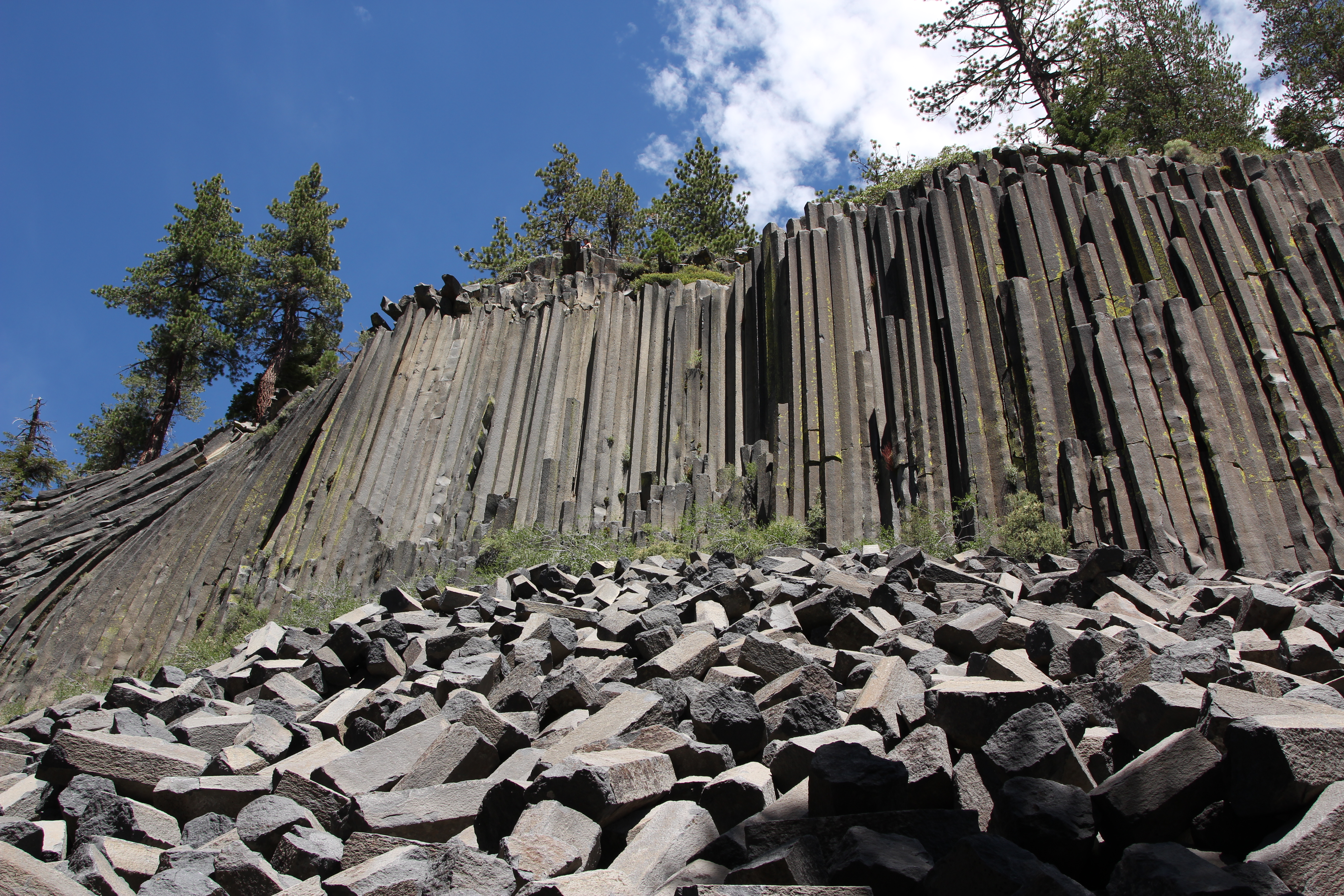
Established in 1911 by presidential proclamation, Devils Postpile National Monument protects and preserves the Devils Postpile formation, the 101-foot high Rainbow Falls, and pristine mountain scenery...
9 mi from route
~23 min detour
Free
near mile 401.1
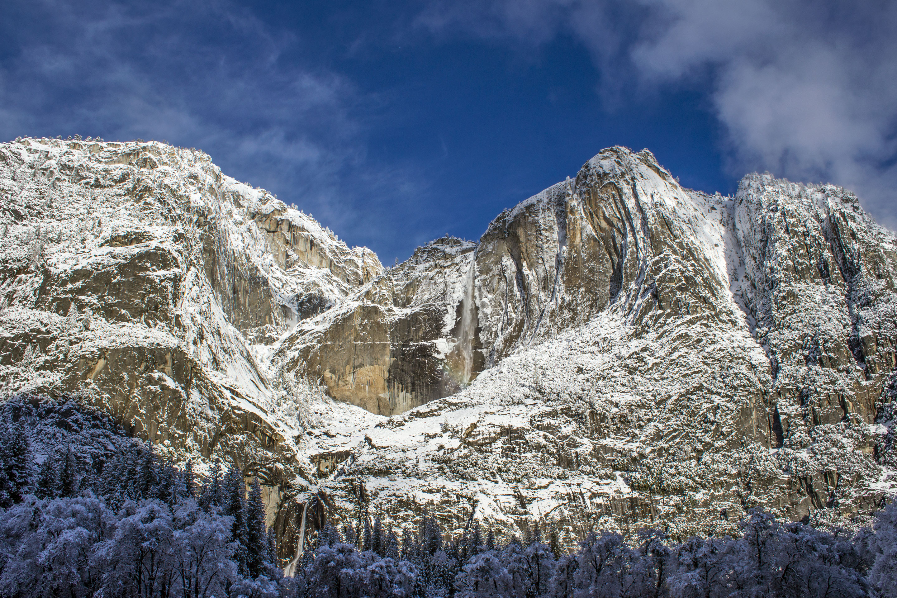
Not just a great valley, but a shrine to human foresight, the strength of granite, the power of glaciers, the persistence of life, and the tranquility of the High Sierra. First protected in 1864, Yose...
25 mi from route
~63 min detour
$35
near mile 423.4
Park data from the National Park Service API. Alerts update every 2 hours.
More Details
What kind of drive is this?
Expect a varied experience behind the wheel, as roughly 44% of this route consists of highway travel. The journey features a mix of major thoroughfares and open stretches, highlighted by a longest uninterrupted segment of 104.5 miles along the Grand Army of the Republic Highway. You will feel the transition from the densely populated southern regions toward the northern interior as the road profile shifts. While the interstate sections allow for steady progress, the nature of the route requires you to stay alert through changing environments. It is a classic long-distance endurance drive that blends high-speed transit with the practical realities of navigating California’s primary road network.
44% highway, the rest on surface roads — varied driving throughout.
60 navigation steps total — most of the decisions cluster near the start and finish.
Longest single stretch: 104.5 mi on Grand Army of the Republic Highway.
How Hard Is This Drive?
10/10
At 13h, this is a long-haul route where pacing matters more than any single turn. This route has several spots where lane changes, forks, or exits need your full attention. The trickiest moment comes around 1 miles in.
Driving Effort10/10
High effort - long or complex enough to need steady focus all day
Balances navigation complexity with total wheel time.
This is a demanding drive. With 28 significant decision points across 646.3 miles, you will need to stay alert - especially through interchange areas and urban stretches. Consider splitting it into segments if you are not comfortable with fast highway navigation.
Where does it get tricky?
The main spots that need attention: at 1 miles: Lane positioning matters here; at 1.5 miles: Exit ramp - move to the correct lane early. Lane positioning matters here; at 1.7 miles: Highway fork - watch signs carefully. Lane positioning matters here.
Elevation Profile
Mountain driving with significant elevation changes
7,402 ft66 ft
Total Climb
8,655 ft
Total Descent
4,526 ft
Highest Point
7,402 ft
~461.6 mi in
Elevation Range
7,337 ft
Notable High Points
3,761 ft at ~138.5 miles+1,178 ft prominence
7,402 ft at ~461.6 miles+79 ft prominence
Towns Mentioned on Route Signs
Based on OSRM destination-sign hints, not a full list of every settlement the road passes.
Between Chula Vista, CA and Susanville, CA, road signs point toward Barstow, Bishop, Dayton and Fallon.
Chula Vista is a large city in San Diego County in Southern California. It was a farming and dairy city in the early 20th century. By the early 21st century the city had grown tremendously with the addition of several prominent suburbs and business districts.
=== Understand ===
Chula Vista Convention & Visitors Bureau website
Long-haul drive route profile with national parks nearby.
Frequently Asked Questions
The longest stretch is about 104.5 miles on Grand Army of the Republic Highway. The full list of main roads is in the Roads section above.
Yes — a 2-day pace is more comfortable than one long haul. A sensible stopping point is after roughly 323 miles on day one.
Yes — we found about 12 rest areas or service plazas within a short detour of the route (from OpenStreetMap). See the Rest Stops tab under Nearby Places for locations and mile markers. Plan to stretch, use the bathroom, and top off fluids every 2–3 hours on longer drives.
It helps. This route has a higher-than-average number of complex decision points, which get harder in the dark. If the last hour of the trip is on surface roads or mountain grades, aim to arrive at Susanville, CA before sunset when you can. Check the Trip Plan for departure windows that land you in daylight.
Only with planning. This is a long drive for kids — consider splitting it into two days rather than pushing through. Plan at least 3 meaningful breaks. There are 12 rest areas along the route for bathroom stops.
The main spots that need attention: at 1 miles: Lane positioning matters here; at 1.5 miles: Exit ramp - move to the correct lane early. Lane positioning matters here; at 1.7 miles: Highway fork - watch signs carefully. Lane positioning matters here.
Yes — Cabrillo National Monument, Devils Postpile National Monument and Yosemite National Park. See the National Parks section for detour distances and tips on detours.
Not recommended in a single day. At 13.0 hours each way, a round trip means 26.0 hours of driving — that is an unsafe level of fatigue for most drivers. Plan at least one night at Susanville, CA before the return drive.