Embarking on the 570.8-mile journey from Los Angeles to Susanville is a significant undertaking that requires careful planning. With a total driving time of roughly 11 hours and 2 minutes, this trip is best approached as a two-day excursion rather than a single-day grind. You will primarily navigate via the Westside Freeway, Deer Creek Highway, and CA 70, making your way through the diverse landscapes of the Pacific Coast. Budgeting approximately $132 for fuel is a smart move before you head out. Because the route crosses such a vast distance, splitting the drive into two days ensures you arrive in Susanville feeling refreshed rather than exhausted.
Trip Pace
Best split across 2 days
Treat the return leg as its own travel day rather than an afterthought.
Break Rhythm
3 planned breaks
Plan on a short reset every 3 to 4 hours to stay fresh behind the wheel.
Midpoint
285.4 miles from Los Angeles, CA
A natural place for your longest stop of the day
, about 5h 15m into the drive
.
Main Roads
Road
Distance
Duration
Westside Freeway
304.9 mi
5h 29m
Deer Creek Highway
52.3 mi
1h 9m
CA 70
52 mi
1h
I 5 Truck
37.7 mi
43m
CA 36
29.5 mi
40m
Golden State Freeway
29 mi
33m
State Highway 36 East
18.1 mi
26m
Hollywood Freeway
15.5 mi
19m
Longest stretch:
Westside Freeway
— 304.9 mi, about 5h 29m
Traffic on I-5
Hour-of-day weekday pattern from 214 FHWA count stations on your route.
Peak
3 PM
~3,927 veh/hr typical
· worst 5,115
Quietest
2 AM
~561 veh/hr
Peak-to-quiet ratio
7×
busier at peak than in the quiet hours
12a6anoon6p11p
Averaged across 44 weeks of 2023 FHWA Travel Monitoring Analysis System data. Weekday hours only (Mon–Fri).
Turn-by-Turn Driving Directions
Step-by-step road directions between Los Angeles, CA and Susanville, CA.
1
Start on West 1st Street
0.1 mi·32 sec·West 1st Street
2
Turn right onto North Broadway
0.4 mi·49 sec·North Broadway
3
Take the ramp
0.2 mi·30 sec
Toward US 101 North, CA 110
4
Merge onto US 101
0.7 mi·55 sec·Santa Ana Freeway
5
Continue on US 101
15 mi·19 min·Hollywood Freeway
Use the straight / slight right lanes.
6
Keep slight left at fork
0.9 mi·59 sec
Use the straight / slight right lanes.
7
Merge onto I 5
4.5 mi·5 min·Golden State Freeway
Use the straight / slight right lanes.
8
Keep slight left at fork onto I 5
2.2 mi·2 min·Golden State Freeway
Use the straight / slight right lanes.
9
Keep slight right at fork onto I 5 Truck
1.5 mi·1 min·I 5 Truck
Exit 161AToward I 5 Truck North, CA 14 TruckUse the straight / slight right lanes.
10
Keep slight left at fork onto I 5 Truck
36 mi·41 min·I 5 Truck
Use the straight / slight right lanes.
11
Keep slight left at fork onto I 5
22 mi·25 min·Golden State Freeway
Use the straight / slight right lanes.
12
Keep slight right at fork onto I 5
226 mi·4 hr 1 min·Westside Freeway
Toward I 5 NorthUse the straight / slight right lanes.
13
Keep slight right at fork onto I 5
26 mi·27 min·Westside Freeway
14
Keep left at fork onto I 5
54 mi·59 min·Westside Freeway
Use the straight / slight right lanes.
15
Keep slight right at fork onto CA 99
7.5 mi·8 min·Golden State Highway
Toward CA 99 North, CA 70: Yuba City, MarysvilleUse the straight / slight right lanes.
16
Continue on CA 99
5.0 mi·5 min·Bernie Richter Memorial Highway
17
Keep slight right at fork onto CA 70
22 mi·25 min·CA 70
Toward CA 70 North: Marysville, OrovilleUse the straight / slight right lanes.
18
Turn right onto 5th Street
0.2 mi·38 sec·5th Street
19
Turn left onto B Street
1.5 mi·3 min·B Street
Use the straight / right lanes.
20
Continue on CA 70
30 mi·35 min·CA 70
Use the left lane.
21
Keep slight left at fork onto CA 149
5.7 mi·6 min·CA 149
Use the straight lane.
22
Merge onto CA 99
9.5 mi·11 min·CA 99
Use the straight lane.
23
Take the exit
0.2 mi·15 sec
Toward CA 32: Orland, Chester
24
Turn right onto CA 32
52 mi·1 hr 9 min·Deer Creek Highway
Use the right lane.
25
At end of road, turn right onto CA 36; CA 89
18 mi·26 min·State Highway 36 East
26
Enter roundabout onto CA 36
92 ft·6 sec·CA 36
27
Continue on CA 36
29 mi·39 min·CA 36
28
Turn right onto Foss Street
61 ft·2 sec·Foss Street
29
Arrive at destination
Foss Street
Trip Plan
To manage the 570.8-mile distance effectively, plan for at least three stops to stretch your legs and keep your energy levels consistent. Given the length of the trip, leaving early in the morning is essential to avoid unnecessary fatigue. Since you are facing a significant fuel expense of roughly $132, keep an eye on your gauge during the 304.9-mile stretch on the Westside Freeway, where service stations may be spaced further apart. If you follow the recommendation to split the trip over two days, look for a midpoint stop that allows you to break up the drive evenly. Prioritizing consistent rest stops will make the transition between the major highway segments much more manageable.
Morning Departure
Start early — leave by 6-7 AM to arrive at a reasonable hour.
Evening Departure
This is a long drive — plan for a morning departure or consider splitting it into two days.
This drive is better paced as a 2-day trip.
Plan roughly 3 meaningful breaks for fuel, food, and rest.
The halfway point lands around 285.4 miles from Los Angeles, CA, or about 5h 15m into the drive.
The longest continuous stretch on this route runs about 304.9 miles.
Consider an overnight stop or starting very early.
Departure
Before you leave
Start with fuel, water, and navigation already sorted so the first hour feels easy.
First stop
Around 126 miles or 2h 24m in
Use this first pause for coffee, a restroom break, and a quick traffic check ahead.
Halfway reset
Around 285.4 miles or 5h 15m in
This is the best place for your longest stop, a real meal, and a full fuel check.
Overnight split
Day 1 wrap after about 285.4 miles or 5h 15m
Stop before fatigue turns the last few hours into a grind. You want day two to start fresh, not just resumed.
Final approach
Final hour starts around 9h 39m
Traffic, exits, and arrival timing usually matter more near Susanville, CA than in the middle of the route.
Before You Leave
+
Open the route before leaving Los Angeles, CA so your first major turns are already loaded.
+
Leave with enough water and a charging cable within reach, not packed away.
+
Check your fuel range against the first long segment, especially if you are starting outside city service areas.
+
Pick one backup stop option before the midpoint in case traffic changes your pacing.
+
Treat this as a 2-day road trip and book the overnight stop before the busiest arrival window.
Day 1
Settle into the route from Los Angeles, CA
Aim for roughly 285 miles and 5.5 hours of wheel time on this day.
Day 2
Finish the approach into Susanville, CA
Aim for roughly 285 miles and 5.5 hours of wheel time on this day.
Your first comfortable stop window is around 126 miles from Los Angeles, CA.
This route usually feels better as a 2-day drive than as one long push.
Plan about 3 real breaks rather than only quick fuel stops.
The longest stretch is on Westside Freeway for about 304.9 miles.
Where to Stop
Rest stops, refuel points, and overnight suggestions along this route.
Place data sourced from public business listings. Hours and availability may vary.
Heads-up: tricky spots
5 of 23
5 decision points cluster between mile 16.9 and 401.8 — GPS handles the exact turns, but know they're coming. Your lane choice matters more than the turn itself.
6
16.9 mi into trip|~22m in
Keep slight left at fork
Highway fork - watch signs carefully. Lane positioning matters here
Use the straight / slight right lanes.
9
24.5 mi into trip|~31m in|I 5 Truck
Keep slight right at fork onto I 5 Truck toward I 5 Truck North, CA 14 Truck
Highway fork - watch signs carefully. Lane positioning matters here. Multiple destination signs - pick the right one
Use the straight / slight right lanes.
Exit 161A
Toward I 5 Truck North, CA 14 Truck
7
84.5 mi into trip|~1h 40m in|I 5 / Westside Freeway
Keep slight right at fork onto I 5 / Westside Freeway toward I 5 North
Highway fork - watch signs carefully. Lane positioning matters here
Use the straight / slight right lanes.
Toward I 5 North
8
389.4 mi into trip|~7h 9m in|CA 99 / Golden State Highway
Keep slight right at fork onto CA 99 / Golden State Highway toward CA 99 North, CA 70: Yuba City, Marysville
Highway fork - watch signs carefully. Lane positioning matters here. Multiple destination signs - pick the right one
Use the straight / slight right lanes.
Toward CA 99 North, CA 70: Yuba City, Marysvill...
8
401.8 mi into trip|~7h 23m in|CA 70
Keep slight right at fork onto CA 70 toward CA 70 North: Marysville, Oroville
Highway fork - watch signs carefully. Lane positioning matters here. Multiple destination signs - pick the right one
Use the straight / slight right lanes.
Toward CA 70 North: Marysville, Oroville
Fuel & Cost
Regular Gas
$119.42 one way
$238.84 round trip
$5.31/gal25.4 MPG avg200 kg CO2
Fuel Type
$/gal
One Way
Round Trip
midgrade
$5.52
$124.03
$248.05
premium
$5.67
$127.31
$254.61
diesel
$4.80
$107.78
$215.56
No toll roads detected on this route.
Estimated Trip Cost (one way, 1 person)
Fuel
$119
Hotel (1n)
$80–$140
Meals
$50–$100
Total
$249–$359
Rough estimate based on US averages. Hotel $80–$140/night, meals $25–$50/day.
Estimated CO2 emission: 199.7 kg one way.
Prices: EIA weekly data, 2026-07-13.
Driving Electric?
About $60 in charging
· 2 stops
· 67% less CO2
Vehicle Type
kWh
Stops
DC Fast
Home Charge
Average EV
171.2
2
$59.93
$27.40
Efficient EV
142.7
1
$49.95
$22.83
EV Truck/SUV
228.3
2
$79.91
$36.53
Gas CO2
200 kg
EV CO2
67 kg (67% less)
Plan for 2 charging stops, roughly every 270 miles. Allow 25-40 minutes per stop at a DC fast charger.
DC fast charging avg $0.35/kWh. Home charging avg $0.16/kWh. US grid CO2: 0.39 kg/kWh.
Travel Intel
Current conditions at both ends of the drive.
Forecast as of Jul 16, 2026
Origin
Los Angeles, CA
Evening
in Los Angeles on Saturday
Local time
5:47 PM
PDT
Current temp
92°F
Sunny
SSW 5 to 10 mph1% chanceLive forecast
Extreme Heat Warning
Extreme Heat Warning issued July 16 at 1:29PM PDT until July 16 at 8:00PM PDT by NWS San Diego CA
Extreme Heat Warning
Extreme Heat Warning issued July 16 at 1:29PM PDT until July 16 at 8:00PM PDT by NWS San Diego CA
Destination
Susanville, CA
Evening
in Susanville on Saturday
Local time
5:47 PM
PDT
Current temp
92°F
Sunny
SW 10 to 15 mph0% chanceLive forecast
Extreme Heat Warning
Extreme Heat Warning issued July 16 at 1:29PM PDT until July 16 at 8:00PM PDT by NWS San Diego CA
Extreme Heat Warning
Extreme Heat Warning issued July 16 at 1:29PM PDT until July 16 at 8:00PM PDT by NWS San Diego CA
Seasonal Notes
Summer travel usually means heavier construction, hotter rest stops, and busier weekend traffic around major cities.
Winter travel shortens daylight, so a route that looks manageable on paper can feel much longer after dark.
Holiday weekends tend to make both departure and arrival windows slower than the raw route time suggests.
For long drives, weather on day two can matter just as much as conditions at departure, so check the whole travel window rather than only the first day.
Time zone
Same local time
Origin and destination are on the same clock, so arrival timing is easier to judge at a glance.
Temperature spread
Very similar conditions
Both ends of the route are sitting at about the same temperature right now.
Road read
11h 2m on the road
This is long enough that the arrival forecast matters almost as much as departure conditions. Recheck both ends before you roll.
Weather data from the National Weather Service. Conditions may change; check closer to your travel date.
National Parks Near This Route
Worth a detour if your schedule allows.
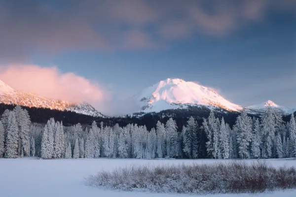
Lassen Volcanic National Park
National Park
Lassen Volcanic National Park is home to steaming fumaroles, meadows freckled with wildflowers, clear mountain lakes, and numerous volcanoes. Jagged peaks tell the story of its eruptive past while hot...
17 mi from route
~43 min detour
$30
near mile 531.5
Park Closure: Roads to Juniper Lake and Warner Valley Closed for Repairs
Park Closure: Lassen National Park Highway under Seasonal Closure
The Santa Monica Mountains offer easy access to surprisingly wild places. Experience the famous beaches of Malibu or explore more than 500 miles of trails. The park abounds with historical and cultura...
22 mi from route
~55 min detour
Free
near mile 19.7
Yes, we can! Widely recognized as the most important Latino leader in the United States during the twentieth century, Cesar Chavez led farm workers and supporters in the establishment of the country's...
29 mi from route
~73 min detour
Free
near mile 78.7
Park data from the National Park Service API. Alerts update every 2 hours.
More Details
What kind of drive is this?
Expect a varied experience behind the wheel, as this route is composed of 88% highways. You will spend a substantial portion of your time on the Westside Freeway, which accounts for the longest single stretch of 304.9 miles. This initial phase offers a straightforward, high-speed pace, but the character of the road shifts significantly as you transition toward the Deer Creek Highway and CA 70. These segments introduce a different rhythm, requiring more attention than the open stretches of the interstate. By the time you reach the final legs of the journey, the landscape and road conditions will feel quite distinct from your departure point in Southern California.
88% highway — fuel and pacing are the main things to plan.
29 navigation steps total — most of the decisions cluster near the start and finish.
Longest single stretch: 304.9 mi on Westside Freeway.
How Hard Is This Drive?
8/10
This is a straightforward highway drive that stays mostly on Westside Freeway and Deer Creek Highway. This route has several spots where lane changes, forks, or exits need your full attention. The trickiest moment comes around 16.9 miles in.
Driving Effort8/10
Demanding - plan breaks and stay ahead of the key maneuvers
Balances navigation complexity with total wheel time.
This is a demanding drive. With 23 significant decision points across 570.8 miles, you will need to stay alert - especially through interchange areas and urban stretches. Consider splitting it into segments if you are not comfortable with fast highway navigation.
Where does it get tricky?
The main spots that need attention: at 16.9 miles: Highway fork - watch signs carefully. Lane positioning matters here; at 24.5 miles (I 5 Truck): Highway fork - watch signs carefully. Lane positioning matters here. Multiple destination signs - pick the right one; at 84.5 miles (I 5 / Westside Freeway): Highway fork - watch signs carefully. Lane positioning matters here.
Elevation Profile
High-altitude sections with notable climbs
4,890 ft17 ft
Total Climb
6,209 ft
Total Descent
2,299 ft
Highest Point
4,890 ft
~530.1 mi in
Elevation Range
4,872 ft
Notable High Points
4,890 ft at ~530.1 miles+696 ft prominence
Towns Mentioned on Route Signs
Based on OSRM destination-sign hints, not a full list of every settlement the road passes.
Between Los Angeles, CA and Susanville, CA, road signs point toward Marysville, Oroville and Chester.
Frank Lloyd Wright is said to have quipped, "Tip the world over on its side and everything loose will land in Los Angeles," a quote that has since been repeated both by those who love and hate L.A. The "City of Angels" is home to people who hail from all parts of the globe and an important center of culture, business, media, and international trade. However, it's most famous for being a major center of the world's television, motion picture, and music industry, which forms the base of the city's status and lures visitors for its show business history and celebrity culture. Visitors are also drawn to Los Angeles for its Mediterranean climate and numerous beaches, which gave birth to California's famed surf culture.
Top landmarks
•Hollywood Walk of Fame — more than 2,700 five-pointed terrazzo and brass stars embedded in the sidewalks...
•Hollywood Sign — sign reading "HOLLYWOOD" located in Los Angeles, California, United States
•Getty Center — campus of the Getty Museum and other programs of the Getty Trust in Los Angeles
The longest stretch is about 304.9 miles on Westside Freeway. The full list of main roads is in the Roads section above.
Yes — a 2-day pace is more comfortable than one long haul. A sensible stopping point is after roughly 285 miles on day one.
Yes — we found about 38 rest areas or service plazas within a short detour of the route (from OpenStreetMap). See the Rest Stops tab under Nearby Places for locations and mile markers. Plan to stretch, use the bathroom, and top off fluids every 2–3 hours on longer drives.
It helps. This route has a higher-than-average number of complex decision points, which get harder in the dark. If the last hour of the trip is on surface roads or mountain grades, aim to arrive at Susanville, CA before sunset when you can. Check the Trip Plan for departure windows that land you in daylight.
Only with planning. This is a long drive for kids — consider splitting it into two days rather than pushing through. Plan at least 3 meaningful breaks. There are 38 rest areas along the route for bathroom stops.
The main spots that need attention: at 16.9 miles: Highway fork - watch signs carefully. Lane positioning matters here; at 24.5 miles (I 5 Truck): Highway fork - watch signs carefully. Lane positioning matters here. Multiple destination signs - pick the right one; at 84.5 miles (I 5 / Westside Freeway): Highway fork - watch signs carefully. Lane positioning matters here.
Yes — Lassen Volcanic National Park, Santa Monica Mountains National Recreation Area and César E. Chávez National Monument. See the National Parks section for detour distances and tips on detours.
Not recommended in a single day. At 11.0 hours each way, a round trip means 22.1 hours of driving — that is an unsafe level of fatigue for most drivers. Plan at least one night at Susanville, CA before the return drive.