Embarking on the 547.7-mile journey from Riverside to Susanville is a significant commitment that requires roughly 11 hours and 8 minutes of driving time. Because of this duration, it is highly recommended to split the trip over two days rather than attempting it in one exhausting stretch. Your path will primarily utilize the Grand Army of the Republic Highway, the Blue Star Memorial Highway, and I-580 to traverse the state. Expect to set aside approximately $127 for fuel costs to complete the transit. This trip stays entirely within the Pacific Coast region, yet the transition from the bustling landscape of Riverside to the environment of Susanville offers a complete shift in scenery. Planning for an overnight stay will ensure you arrive refreshed rather than depleted by the long hours behind the wheel.
Trip Pace
Best split across 2 days
Treat the return leg as its own travel day rather than an afterthought.
Break Rhythm
3 planned breaks
Plan on a short reset every 3 to 4 hours to stay fresh behind the wheel.
Midpoint
273.9 miles from Riverside, CA
A natural place for your longest stop of the day
, about 5h 29m into the drive
.
Main Roads
Road
Distance
Duration
Grand Army of the Republic Highway
104.5 mi
2h 2m
Blue Star Memorial Highway
103.3 mi
2h 3m
I 580
101.1 mi
1h 55m
North Sierra Highway
87.4 mi
1h 44m
Route 395
43.3 mi
56m
Main Street
19.3 mi
26m
US 395
14.7 mi
22m
Carson City Deputy Sheriff Carl Howell Memorial Freeway
13.2 mi
14m
Longest stretch:
Grand Army of the Republic Highway
— 104.5 mi, about 2h 2m
Traffic on I-15
Hour-of-day weekday pattern from 18 FHWA count stations on your route.
Peak
2 PM
~5,301 veh/hr typical
Quietest
1 AM
~1,169 veh/hr
Peak-to-quiet ratio
4.5×
busier at peak than in the quiet hours
12a6anoon6p11p
Averaged across 46 weeks of 2023 FHWA Travel Monitoring Analysis System data. Weekday hours only (Mon–Fri).
Turn-by-Turn Driving Directions
Step-by-step road directions between Riverside, CA and Susanville, CA.
1
Start on this road
87 ft·8 sec·this road
2
Turn slight right onto Central Avenue
0.7 mi·1 min·Central Avenue
3
Take the ramp
0.3 mi·37 sec
Toward CA 91 East: San BernardinoUse the left lane.
4
Merge onto CA 91
8.6 mi·9 min·Riverside Freeway
Use the straight / slight right lanes.
5
Continue on I 215
5.5 mi·6 min·San Bernardino Freeway
Use the straight / slight right lanes.
6
Continue on I 215
8.9 mi·9 min·Barstow Freeway
Use the straight / slight right lanes.
7
Keep slight left at fork
0.2 mi·13 sec
8
Continue on I 15
6.8 mi·7 min·Barstow and Mojave Freeway
Use the straight / slight right lanes.
9
Continue on I 15; US 66 Hist; US 91 Hist; US 395 Hist
5.4 mi·5 min·CHP Officer Larry L. Wetterling and San Bernardino County Sheriff's Lieutenant Alfred E. Stewart Memorial Highway
Use the straight / slight right lanes.
10
Continue on I 15; US 66 Hist
2.8 mi·3 min·Barstow and Mojave Freeway
Use the straight / slight right lanes.
11
Take the exit
0.3 mi·37 sec
Exit 141Toward US 395 North: Adelanto, Bishop
12
Continue on this road
0.9 mi·1 min·this road
Exit 141Toward US 395 North: Adelanto, Bishop
13
Continue on US 395
67 mi·1 hr 20 min·Blue Star Memorial Highway
Use the straight / right lanes.
14
Continue on US 395
0.9 mi·1 min·Red Mountain Road
15
Continue on US 395
37 mi·42 min·Blue Star Memorial Highway
Use the straight lane.
16
Continue on US 395; US 6 Hist
56 mi·1 hr 4 min·Grand Army of the Republic Highway
Use the straight lane.
17
Continue on US 395; US 6 Hist
2.2 mi·4 min·South Main Street
18
Continue on US 395; US 6 Hist
15 mi·17 min·Grand Army of the Republic Highway
Use the straight lane.
19
Continue on US 395; US 6 Hist
0.7 mi·1 min·South Edwards Street
20
Continue on US 395; US 6 Hist
26 mi·31 min·Grand Army of the Republic Highway
Use the straight lane.
21
Continue on US 395; US 6 Hist
0.2 mi·32 sec·North Main Street
22
Continue on US 395; US 6 Hist
7.4 mi·8 min·Grand Army of the Republic Highway
23
Continue on US 395; CA 168; US 6 Hist
5.0 mi·5 min·El Camino Sierra
Use the straight lane.
24
Continue on US 395; CA 168; US 6 Hist
2.4 mi·4 min·South Main Street
Use the straight lane.
25
Turn left onto CA 168
1.5 mi·2 min·West Line Street
Use the left lane.
26
Turn right onto North Barlow Lane
1.0 mi·1 min·North Barlow Lane
27
Turn left onto US 395
87 mi·1 hr 44 min·North Sierra Highway
Use the straight lane.
28
Turn right onto Sinclair Street
0.1 mi·12 sec·Sinclair Street
29
Turn left onto Emigrant Street
0.5 mi·40 sec·Emigrant Street
30
Continue on US 395
43 mi·56 min·Route 395
Use the left lane.
31
Continue on US 395
19 mi·26 min·Main Street
32
Continue on US 395
2.9 mi·7 min·US 395
33
Turn left onto County Road
1.1 mi·1 min·County Road
34
Enter roundabout onto NV 88
2 ft·0 sec·Woodfords Road
35
Continue on NV 88
0.4 mi·48 sec·Woodfords Road
36
Turn left onto US 395
11 mi·13 min·US 395
Use the straight / right lanes.
37
Take the exit onto US 395
0.9 mi·1 min·US 395
Toward I 580 North, US 395 North, US 50 East: Reno, Dayton, FallonUse the straight / slight right lanes.
38
Merge onto I 580; US 50; US 395
13 mi·14 min·Carson City Deputy Sheriff Carl Howell Memorial Freeway
39
Continue on I 580; US 395
101 mi·1 hr 55 min·I 580; US 395
40
Continue on CA 36
4.3 mi·7 min·CA 36
Use the straight / right lanes.
41
Turn left onto Foss Street
61 ft·2 sec·Foss Street
42
Arrive at destination
Foss Street
Trip Plan
To manage this lengthy drive effectively, schedule at least three strategic stops to break up the 11-hour transit. Leaving Riverside early in the morning is your best strategy to avoid mid-day congestion and ensure you reach your midway point before dark. Given the $127 estimated fuel budget, keep a close eye on your tank levels during the longest 104.5-mile stretch on the Grand Army of the Republic Highway, where services may be spaced further apart. Since this is a substantial trek, prioritize flexibility by checking for road updates before you depart. Consider splitting the drive near the halfway mark to keep your energy levels consistent throughout the two-day trip.
Morning Departure
Start early — leave by 6-7 AM to arrive at a reasonable hour.
Evening Departure
This is a long drive — plan for a morning departure or consider splitting it into two days.
This drive is better paced as a 2-day trip.
Plan roughly 3 meaningful breaks for fuel, food, and rest.
The halfway point lands around 273.9 miles from Riverside, CA, or about 5h 29m into the drive.
The longest continuous stretch on this route runs about 104.5 miles.
Consider an overnight stop or starting very early.
Departure
Before you leave
Start with fuel, water, and navigation already sorted so the first hour feels easy.
First stop
Around 120 miles or 2h 23m in
Use this first pause for coffee, a restroom break, and a quick traffic check ahead.
Halfway reset
Around 273.9 miles or 5h 29m in
This is the best place for your longest stop, a real meal, and a full fuel check.
Overnight split
Day 1 wrap after about 273.9 miles or 5h 29m
Stop before fatigue turns the last few hours into a grind. You want day two to start fresh, not just resumed.
Final approach
Final hour starts around 9h 56m
Traffic, exits, and arrival timing usually matter more near Susanville, CA than in the middle of the route.
Before You Leave
+
Open the route before leaving Riverside, CA so your first major turns are already loaded.
+
Leave with enough water and a charging cable within reach, not packed away.
+
Check your fuel range against the first long segment, especially if you are starting outside city service areas.
+
Pick one backup stop option before the midpoint in case traffic changes your pacing.
+
Treat this as a 2-day road trip and book the overnight stop before the busiest arrival window.
Day 1
Settle into the route from Riverside, CA
Aim for roughly 274 miles and 5.6 hours of wheel time on this day.
Day 2
Finish the approach into Susanville, CA
Aim for roughly 274 miles and 5.6 hours of wheel time on this day.
Your first comfortable stop window is around 120 miles from Riverside, CA.
This route usually feels better as a 2-day drive than as one long push.
Plan about 3 real breaks rather than only quick fuel stops.
The longest stretch is on Grand Army of the Republic Highway for about 104.5 miles.
Where to Stop
Rest stops, refuel points, and overnight suggestions along this route.
Place data sourced from public business listings. Hours and availability may vary.
Heads-up: tricky spots
5 of 16
5 decision points cluster between mile 0.8 and 428.3 — GPS handles the exact turns, but know they're coming. Your lane choice matters more than the turn itself.
6
0.8 mi into trip|~1m in
Take the ramp toward CA 91 East: San Bernardino
Lane positioning matters here
Use the left lane.
Toward CA 91 East: San Bernardino
5
1 mi into trip|~2m in|CA 91 / Riverside Freeway
Merge onto CA 91 / Riverside Freeway
Merge point - match speed before joining. Lane positioning matters here
Use the straight / slight right lanes.
6
39.4 mi into trip|~44m in
Take the exit toward US 395 North: Adelanto, Bishop
Exit ramp - move to the correct lane early. Multiple destination signs - pick the right one
Exit 141
Toward US 395 North: Adelanto, Bishop
5
259.9 mi into trip|~5h 11m in|CA 168 / West Line Street
Turn left onto CA 168 / West Line Street
Lane positioning matters here
Use the left lane.
7
428.3 mi into trip|~8h 48m in|US 395
Take the exit onto US 395 toward I 580 North, US 395 North, US 50 East: Reno, Dayton, Fallon
Exit ramp - move to the correct lane early. Lane positioning matters here. Multiple destination signs - pick the right one
Use the straight / slight right lanes.
Toward I 580 North, US 395 North, US 50 East: R...
Fuel & Cost
Regular Gas
$114.59 one way
$229.17 round trip
$5.31/gal25.4 MPG avg192 kg CO2
Fuel Type
$/gal
One Way
Round Trip
midgrade
$5.52
$119.01
$238.01
premium
$5.67
$122.15
$244.31
diesel
$4.80
$103.42
$206.83
No toll roads detected on this route.
Estimated Trip Cost (one way, 1 person)
Fuel
$115
Hotel (1n)
$80–$140
Meals
$50–$100
Total
$245–$355
Rough estimate based on US averages. Hotel $80–$140/night, meals $25–$50/day.
Estimated CO2 emission: 191.6 kg one way.
Prices: EIA weekly data, 2026-07-13.
Driving Electric?
About $58 in charging
· 2 stops
· 67% less CO2
Vehicle Type
kWh
Stops
DC Fast
Home Charge
Average EV
164.3
2
$57.51
$26.29
Efficient EV
136.9
1
$47.92
$21.91
EV Truck/SUV
219.1
2
$76.68
$35.05
Gas CO2
192 kg
EV CO2
64 kg (67% less)
Plan for 2 charging stops, roughly every 270 miles. Allow 25-40 minutes per stop at a DC fast charger.
DC fast charging avg $0.35/kWh. Home charging avg $0.16/kWh. US grid CO2: 0.39 kg/kWh.
Travel Intel
Current conditions at both ends of the drive.
Forecast as of Jul 16, 2026
Origin
Riverside, CA
Late night
in Riverside on Sunday
Local time
12:04 AM
PDT
Current temp
99°F
Sunny
W 10 to 15 mph3% chanceLive forecast
Extreme Heat Warning
Extreme Heat Warning issued July 16 at 1:29PM PDT until July 16 at 8:00PM PDT by NWS San Diego CA
Extreme Heat Warning
Extreme Heat Warning issued July 16 at 1:29PM PDT until July 16 at 8:00PM PDT by NWS San Diego CA
Destination
Susanville, CA
Late night
in Susanville on Sunday
Local time
12:04 AM
PDT
Current temp
92°F
Sunny
SW 15 mph0% chanceLive forecast
Extreme Heat Warning
Extreme Heat Warning issued July 16 at 1:29PM PDT until July 16 at 8:00PM PDT by NWS San Diego CA
Extreme Heat Warning
Extreme Heat Warning issued July 16 at 1:29PM PDT until July 16 at 8:00PM PDT by NWS San Diego CA
Seasonal Notes
Summer travel usually means heavier construction, hotter rest stops, and busier weekend traffic around major cities.
Winter travel shortens daylight, so a route that looks manageable on paper can feel much longer after dark.
Holiday weekends tend to make both departure and arrival windows slower than the raw route time suggests.
For long drives, weather on day two can matter just as much as conditions at departure, so check the whole travel window rather than only the first day.
Time zone
Same local time
Origin and destination are on the same clock, so arrival timing is easier to judge at a glance.
Temperature spread
7 degrees cooler at arrival
A meaningful temperature swing is a good cue to rethink layers, water, and how soon you want to arrive.
Road read
11h 8m on the road
This is long enough that the arrival forecast matters almost as much as departure conditions. Recheck both ends before you roll.
Weather data from the National Weather Service. Conditions may change; check closer to your travel date.
National Parks Near This Route
Worth a detour if your schedule allows.
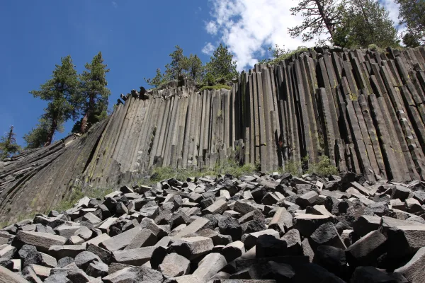
Devils Postpile National Monument
National Monument
Established in 1911 by presidential proclamation, Devils Postpile National Monument protects and preserves the Devils Postpile formation, the 101-foot high Rainbow Falls, and pristine mountain scenery...
9 mi from route
~23 min detour
Free
near mile 302.2
Park Closure: Reds Meadow Road Access Restrictions in 2026
Park Closure: Devils Postpile National Monument facilities are closed for the season
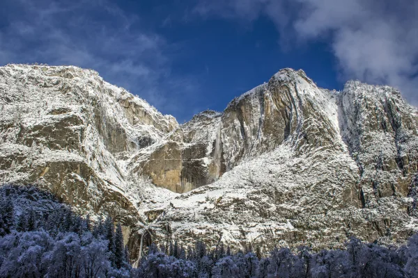
Not just a great valley, but a shrine to human foresight, the strength of granite, the power of glaciers, the persistence of life, and the tranquility of the High Sierra. First protected in 1864, Yose...
26 mi from route
~64 min detour
$35
near mile 321.1
Park data from the National Park Service API. Alerts update every 2 hours.
More Details
What kind of drive is this?
This route presents a distinct mix of road types, with highways accounting for 38% of your total travel time. You will encounter varying road conditions, ranging from efficient interstate segments to more varied highway driving as you head north. The journey features a longest uninterrupted stretch of 104.5 miles along the Grand Army of the Republic Highway, which will test your endurance and focus. As you transition between the different sections of the route, the pace of the drive shifts, requiring you to remain alert to changing traffic patterns. Navigating these 547.7 miles demands a steady hand and a patient approach to the shifting nature of the road infrastructure.
38% highway, the rest on surface roads — varied driving throughout.
42 navigation steps total — most of the decisions cluster near the start and finish.
Longest single stretch: 104.5 mi on Grand Army of the Republic Highway.
How Hard Is This Drive?
6/10
At 11h 8m, this is a long-haul route where pacing matters more than any single turn. You will hit about 16 points where you need to pay attention to lane position or signs. The trickiest moment comes around 0.8 miles in.
Driving Effort6/10
Moderate - straightforward overall, but long enough or busy enough to require pacing
Balances navigation complexity with total wheel time.
This drive requires moderate attention. Across 547.7 miles you will encounter 16 spots where lane choice or exit timing matters. Not difficult for experienced highway drivers, but worth previewing the tricky sections before you go.
Where does it get tricky?
The main spots that need attention: at 0.8 miles: Lane positioning matters here; at 1 miles (CA 91 / Riverside Freeway): Merge point - match speed before joining. Lane positioning matters here; at 39.4 miles: Exit ramp - move to the correct lane early. Multiple destination signs - pick the right one.
Elevation Profile
Mountain driving with significant elevation changes
7,902 ft829 ft
Total Climb
8,851 ft
Total Descent
5,485 ft
Highest Point
7,902 ft
~313 mi in
Elevation Range
7,073 ft
Notable High Points
3,824 ft at ~39.1 miles+1,093 ft prominence
7,902 ft at ~313 miles+1,397 ft prominence
5,148 ft at ~469.5 miles+431 ft prominence
Towns Mentioned on Route Signs
Based on OSRM destination-sign hints, not a full list of every settlement the road passes.
Between Riverside, CA and Susanville, CA, road signs point toward Bishop, Dayton and Fallon.
Riverside is a city in Riverside County in California. With a population of over 300,000, the city plays host to a diverse cross-section of people and has a rich history. Riverside is approximately 55 miles east of downtown Los Angeles. It is a center for higher education, with one community college, a large state university, and two private universities. A hub of regional commerce and transportation, it is a city with an intriguing past and a promising future, and is worth a visit.
Top landmarks
•Mission Inn — hotel in Riverside, California
•Universalist Unitarian Church of Riverside — church building in Riverside, California, USA
•First Congregational Church of Riverside — church building in Riverside, California, United States of America
Moderate complexity with 3 natural rest stops along the way.
Solo Traveler
11h 8m drive, plan rest stops for pacing.
Scenic Drive
Long-haul drive route profile with national parks nearby.
Frequently Asked Questions
The longest stretch is about 104.5 miles on Grand Army of the Republic Highway. The full list of main roads is in the Roads section above.
Yes — a 2-day pace is more comfortable than one long haul. A sensible stopping point is after roughly 274 miles on day one.
Yes — we found about 9 rest areas or service plazas within a short detour of the route (from OpenStreetMap). See the Rest Stops tab under Nearby Places for locations and mile markers. Plan to stretch, use the bathroom, and top off fluids every 2–3 hours on longer drives.
It helps. This route has a higher-than-average number of complex decision points, which get harder in the dark. If the last hour of the trip is on surface roads or mountain grades, aim to arrive at Susanville, CA before sunset when you can. Check the Trip Plan for departure windows that land you in daylight.
Only with planning. This is a long drive for kids — consider splitting it into two days rather than pushing through. Plan at least 3 meaningful breaks. There are 9 rest areas along the route for bathroom stops.
The main spots that need attention: at 0.8 miles: Lane positioning matters here; at 1 miles (CA 91 / Riverside Freeway): Merge point - match speed before joining. Lane positioning matters here; at 39.4 miles: Exit ramp - move to the correct lane early. Multiple destination signs - pick the right one.
Yes — Devils Postpile National Monument and Yosemite National Park. See the National Parks section for detour distances and tips on detours.
Not recommended in a single day. At 11.1 hours each way, a round trip means 22.3 hours of driving — that is an unsafe level of fatigue for most drivers. Plan at least one night at Susanville, CA before the return drive.