Spanning 206.9 miles, this drive from Memphis to Clarksville takes approximately 3 hours and 26 minutes to complete. Because the trip is relatively short, it is perfectly suited for a single-day excursion, meaning you won't need to worry about booking an overnight stay. You can expect to spend about $31 on fuel for the journey, making it a fairly budget-friendly transit across the state. The route primarily utilizes I-40 East, along with segments of North B and Trenton. Since both cities are located within the Southeast region of Tennessee, you will experience a consistent cultural atmosphere throughout your travel. Whether you are heading out for business or a visit, the straightforward nature of this connection makes it an efficient way to cross this portion of the state.
Trip Pace
Same-day drive is realistic
A same-day return is possible, but it will make for a full day on the road.
Break Rhythm
1 planned break
Plan on a short reset every 3 to 4 hours to stay fresh behind the wheel.
Midpoint
101.7 miles from Memphis, TN
A natural place for your longest stop of the day
, about 2h into the drive
.
Main Roads
Road
Distance
Duration
I 40
82.7 mi
1h 32m
Austin Peay Memorial Highway
36.5 mi
41m
Main Street
29.8 mi
36m
East Main Street
16.4 mi
24m
US 45E
13.5 mi
19m
Paris Bypass
7.6 mi
8m
US 45 Bypass
6.6 mi
9m
Atwood Highway
2.8 mi
4m
Longest stretch:
I 40
— 82.7 mi, about 1h 32m
Turn-by-Turn Driving Directions
Step-by-step road directions between Memphis, TN and Clarksville, TN.
1
Start on Poplar Avenue
190 ft·11 sec·Poplar Avenue
2
Turn left onto North B. B. King Boulevard
0.2 mi·33 sec·North B. B. King Boulevard
Use the left lane.
3
Take the ramp
0.1 mi·13 sec
Toward I 40 EastUse the right lane.
4
Merge onto I 40
12 mi·14 min·I 40
Use the straight lane.
5
Keep slight left at fork onto I 40
71 mi·1 hr 17 min·I 40
Toward I 40 East: Nashville, KnoxvilleUse the slight left / straight lanes.
6
Take the exit
0.2 mi·20 sec
Toward TrentonUse the right lane.
7
Merge onto US 45 Bypass
6.6 mi·9 min·US 45 Bypass
Use the straight / right lanes.
8
Take the exit onto US 45E
13 mi·19 min·US 45E
9
Turn right onto US 70A; US 79
2.0 mi·2 min·East Van Hook Street
Use the right lane.
10
Continue on US 70A; US 79
2.1 mi·3 min·Atwood Highway
11
Turn left onto US 70A; US 79
0.7 mi·1 min·Atwood Highway
12
Continue on US 70A; US 79
1.7 mi·2 min·Main Street
13
Keep slight left at fork onto US 79
16 mi·24 min·East Main Street
14
Continue on US 79
12 mi·13 min·Austin Peay Memorial Highway
15
Turn right onto SR 218
7.6 mi·8 min·Paris Bypass
16
Turn right onto US 79; SR 218
24 mi·27 min·Austin Peay Memorial Highway
17
Continue on US 79
0.2 mi·11 sec·Fort Donelson Parkway
18
Continue on US 79
0.6 mi·37 sec·Austin Peay Memorial Highway
19
Continue on US 79
0.5 mi·36 sec·Lake Highway
20
Continue on US 79
1.7 mi·1 min·Donelson Parkway
21
Continue on US 79
28 mi·34 min·Main Street
Use the straight / right lanes.
22
Merge onto US 41A; US 79
0.1 mi·13 sec·Fort Campbell Boulevard
23
Continue on US 41A; US 79
1.6 mi·2 min·Providence Boulevard
Use the straight lane.
24
Continue on US 41A; US 79
0.9 mi·1 min·North 2nd Street
Use the left / straight / right lanes.
25
Arrive at destination
North 2nd Street
Trip Plan
For the best experience, plan your departure to avoid peak local traffic, as the turn-heavy nature of this route can be more demanding during busy hours. Since you only have one planned stop along the way, use that break strategically to refuel and stretch your legs, especially given the $31 estimated fuel cost. Flexibility is your biggest advantage on a trip of this length; if you start to feel fatigued by the local road transitions, don't hesitate to extend your break to ensure you remain sharp behind the wheel. Given the lack of long highway stretches, keep a close watch on your navigation as you transition between North B and the other segments. Prioritize a steady, consistent pace to help manage the technical demands of the local roads throughout the 206.9-mile journey.
Morning Departure
An early start around 7-8 AM gets you there with plenty of daylight left.
Evening Departure
A late afternoon start means arriving after dark. Morning is better.
You can normally do this drive in one day.
Plan roughly 1 meaningful break for fuel, food, and rest.
The halfway point lands around 101.7 miles from Memphis, TN, or about 2h into the drive.
The longest continuous stretch on this route runs about 82.7 miles.
This is a comfortable same-day trip.
Departure
Before you leave
Start with fuel, water, and navigation already sorted so the first hour feels easy.
First stop
Around 45 miles or 51m in
Use this first pause for coffee, a restroom break, and a quick traffic check ahead.
Halfway reset
Around 101.7 miles or 2h in
This is the best place for your longest stop, a real meal, and a full fuel check.
Final approach
Final hour starts around 3h 22m
Traffic, exits, and arrival timing usually matter more near Clarksville, TN than in the middle of the route.
Before You Leave
+
Open the route before leaving Memphis, TN so your first major turns are already loaded.
+
Leave with enough water and a charging cable within reach, not packed away.
+
Check your fuel range against the first long segment, especially if you are starting outside city service areas.
Day 1
Settle into the route from Memphis, TN
This is one driving day of about 203.5 miles and 4h 8m.
Your first comfortable stop window is around 45 miles from Memphis, TN.
This route can stay practical as a one-day drive if traffic stays reasonable.
Plan about 1 real break rather than only quick fuel stops.
The longest stretch is on I 40 for about 82.7 miles.
Where to Stop
Rest stops, refuel points, and overnight suggestions along this route.
Place data sourced from public business listings. Hours and availability may vary.
Heads-up: tricky spots
5 of 13
5 decision points cluster between mile 0 and 103.3 — GPS handles the exact turns, but know they're coming. Your lane choice matters more than the turn itself.
7
0 mi into trip|~0m in|North B. B. King Boulevard
Turn left onto North B. B. King Boulevard
Lane positioning matters here
Use the left lane.
8
0.3 mi into trip|~0m in
Take the ramp toward I 40 East
Lane positioning matters here
Use the right lane.
Toward I 40 East
8
12.3 mi into trip|~15m in|I 40
Keep slight left at fork onto I 40 toward I 40 East: Nashville, Knoxville
Highway fork - watch signs carefully. Lane positioning matters here. Multiple destination signs - pick the right one
Use the slight left / straight lanes.
Toward I 40 East: Nashville, Knoxville
6
83.1 mi into trip|~1h 33m in
Take the exit toward Trenton
Exit ramp - move to the correct lane early. Lane positioning matters here
Use the right lane.
Toward Trenton
6
103.3 mi into trip|~2h 2m in|US 70A; US 79 / East Van Hook Street
Turn right onto US 70A; US 79 / East Van Hook Street
Lane positioning matters here
Use the right lane.
Fuel & Cost
Regular Gas
$31.81 one way
$63.63 round trip
$3.97/gal25.4 MPG avg71 kg CO2
Fuel Type
$/gal
One Way
Round Trip
midgrade
$4.36
$34.93
$69.86
premium
$4.89
$39.16
$78.32
diesel
$5.61
$44.93
$89.86
No toll roads detected on this route.
Estimated Trip Cost (one way, 1 person)
Fuel
$32
Meals
$25–$50
Total
$57–$82
Rough estimate based on US averages. Hotel $80–$140/night, meals $25–$50/day.
Estimated CO2 emission: 71.2 kg one way.
Prices: EIA weekly data, 2026-04-13.
Driving Electric?
About $21 in charging
· 0 stops
· 66% less CO2
Vehicle Type
kWh
Stops
DC Fast
Home Charge
Average EV
61.1
0
$21.37
$9.77
Efficient EV
50.9
0
$17.81
$8.14
EV Truck/SUV
81.4
1
$28.49
$13.02
Gas CO2
71 kg
EV CO2
24 kg (66% less)
This trip is well within single-charge range for most EVs. No charging stops needed if you start fully charged.
DC fast charging avg $0.35/kWh. Home charging avg $0.16/kWh. US grid CO2: 0.39 kg/kWh.
Travel Intel
Current conditions at both ends of the drive.
Forecast as of Apr 15, 2026
Origin
Memphis, TN
Night
in Memphis on Saturday
Local time
9:49 PM
CDT
Current temp
57°F
Unavailable
Live forecast
Destination
Clarksville, TN
Night
in Clarksville on Saturday
Local time
9:49 PM
CDT
Current temp
54°F
Unavailable
Live forecast
78°F
Huntingdon, TN
102 mi in
Seasonal Notes
Summer travel usually means heavier construction, hotter rest stops, and busier weekend traffic around major cities.
Winter travel shortens daylight, so a route that looks manageable on paper can feel much longer after dark.
Holiday weekends tend to make both departure and arrival windows slower than the raw route time suggests.
Time zone
Same local time
Origin and destination are on the same clock, so arrival timing is easier to judge at a glance.
Temperature spread
3 degrees cooler at arrival
A meaningful temperature swing is a good cue to rethink layers, water, and how soon you want to arrive.
Road read
4h 8m on the road
An early start around 7-8 AM gets you there with plenty of daylight left.
Weather data from the National Weather Service. Conditions may change; check closer to your travel date.
National Parks Near This Route
Worth a detour if your schedule allows.
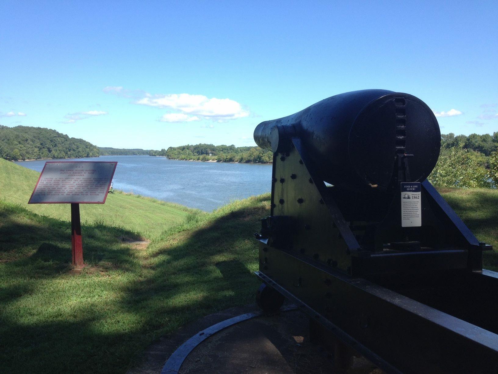
Fort Donelson National Battlefield
National Battlefield
Brigadier General Ulysses S. Grant was becoming quite famous as he wrote these words following the surrender of Confederate Fort Donelson on Sunday, February 16, 1862. The Union victory at Fort Donels...
1 mi from route
~3 min detour
Free
near mile 168.4
Park data from the National Park Service API. Alerts update every 2 hours.
More Details
What kind of drive is this?
This trip is best described as a turn-heavy local drive rather than a monotonous interstate grind. While you will navigate sections of I-40 East, the route features a 0% highway share, placing more emphasis on local roads like North B and Trenton. You should be prepared for frequent maneuvering, as the longest uninterrupted stretch on North B is 0 miles. The character of the road demands your full attention, as the path shifts constantly rather than offering long, straight stretches of pavement. By keeping your focus on the road, you can manage the technical nature of these local connections effectively while moving between your starting point and final destination.
51% highway, the rest on surface roads — varied driving throughout.
25 navigation steps total — most of the decisions cluster near the start and finish.
Longest single stretch: 82.7 mi on I 40.
How Hard Is This Drive?
7/10
This route mixes highway mileage with some local-road sections near the start or finish. This route has several spots where lane changes, forks, or exits need your full attention. The trickiest moment comes early in the drive near North B. B. King Boulevard.
Driving Effort7/10
Demanding - plan breaks and stay ahead of the key maneuvers
Balances navigation complexity with total wheel time.
This is a demanding drive. With 13 significant decision points across 203.5 miles, you will need to stay alert - especially through interchange areas and urban stretches. Consider splitting it into segments if you are not comfortable with fast highway navigation.
Where does it get tricky?
The main spots that need attention: near the start (North B. B. King Boulevard): Lane positioning matters here; at 0.3 miles: Lane positioning matters here; at 12.3 miles (I 40): Highway fork - watch signs carefully. Lane positioning matters here. Multiple destination signs - pick the right one.
Elevation Profile
Mostly flat terrain
637 ft258 ft
Total Climb
642 ft
Total Descent
426 ft
Highest Point
637 ft
~188.9 mi in
Elevation Range
378 ft
Towns Mentioned on Route Signs
Based on OSRM destination-sign hints, not a full list of every settlement the road passes.
Between Memphis, TN and Clarksville, TN, road signs point toward Knoxville and Trenton.
Memphis is the second largest city in the state of Tennessee, after Nashville. The state rests in the southeastern portion of the United States. Memphis, with a population of more than 651,000 (2019), is also the county seat for Shelby County. The city's claims to fame include Graceland, the mansion Elvis Presley lived in during his later years. Perhaps more importantly, Memphis is considered by many to be the home of blues music.
Doable as a same-day drive at 4h 8m. Total distance: 203.5 miles.
Family Friendly
Moderate complexity with 1 natural rest stops along the way.
Solo Traveler
4h 8m drive, comfortable solo distance.
Scenic Drive
Mixed highway & surface route profile with national parks nearby.
Frequently Asked Questions
The longest stretch is about 82.7 miles on I 40. The full list of main roads is in the Roads section above.
We did not find dedicated rest areas on this route. For a drive this long, plan bathroom and stretch breaks around gas stations, fast-food stops, or small-town downtowns — check the Nearby Places section for options.
It helps. This route has a higher-than-average number of complex decision points, which get harder in the dark. If the last hour of the trip is on surface roads or mountain grades, aim to arrive at Clarksville, TN before sunset when you can. Check the Trip Plan for departure windows that land you in daylight.
Only with planning. This is a long drive for kids — consider splitting it into two days rather than pushing through. Plan at least 1 meaningful breaks. Dedicated rest areas are limited, so plan gas or food stops as your bathroom breaks.
The main spots that need attention: near the start (North B. B. King Boulevard): Lane positioning matters here; at 0.3 miles: Lane positioning matters here; at 12.3 miles (I 40): Highway fork - watch signs carefully. Lane positioning matters here. Multiple destination signs - pick the right one.
Yes — Fort Donelson National Battlefield. See the National Parks section for detour distances and tips on detours.
Possible but tiring. At 4.1 hours each way, an in-and-out day trip would put you behind the wheel for 8.3 hours — manageable with a long break at Clarksville, TN, but most travelers stay overnight.