Traveling from Lemmon to Box Elder covers 181.8 miles through the heart of the South Dakota Great Plains. You should plan for a total drive time of approximately 3 hours and 23 minutes, making this a straightforward day trip that does not require an overnight stay. Your journey will primarily utilize 10th Street West, Highway 73, and Highway 20 to navigate between the two points. Budgeting about $28 for fuel should adequately cover your needs for the trip. Since the drive is relatively short, it offers a practical way to transition across the region without the exhaustion of a multi-day trek.
Trip Pace
Same-day drive is realistic
A same-day return is possible, but it will make for a full day on the road.
Break Rhythm
1 planned break
Plan on a short reset every 3 to 4 hours to stay fresh behind the wheel.
Midpoint
104.7 miles from Lemmon, SD
A natural place for your longest stop of the day
, about 2h 33m into the drive
.
Main Roads
Road
Distance
Duration
State Highway 73
85.5 mi
2h 7m
SD Highway 34
76.2 mi
1h 26m
I 90
30.9 mi
32m
State Highway 20
6 mi
8m
US 212
3.2 mi
4m
Highway 1416
2.1 mi
3m
Junction Avenue
1.5 mi
2m
Lazelle Street
1.1 mi
1m
Longest stretch:
State Highway 73
— 85.5 mi, about 2h 7m
Traffic on I-90
Hour-of-day weekday pattern from 16 FHWA count stations on your route.
Peak
5 PM
~1,843 veh/hr typical
· worst 2,177
Quietest
2 AM
~46 veh/hr
Peak-to-quiet ratio
40.1×
busier at peak than in the quiet hours
12a6anoon6p11p
Averaged across 50 weeks of 2023 FHWA Travel Monitoring Analysis System data. Weekday hours only (Mon–Fri).
Turn-by-Turn Driving Directions
Step-by-step road directions between Lemmon, SD and Box Elder, SD.
Given the 3-hour and 23-minute duration, you have plenty of flexibility to depart whenever suits your schedule best. Plan for at least one dedicated stop along the way to stretch your legs and break up the turn-heavy nature of the drive. Since you are relying on local roads like Highway 73 and Highway 20, keep a close eye on your fuel gauge before leaving Lemmon to ensure your $28 estimate holds up throughout the journey. Because this route involves constant turns rather than long, straight stretches, focus on maintaining a consistent pace to keep the drive comfortable for everyone in the vehicle.
Morning Departure
An early start around 7-8 AM gets you there with plenty of daylight left.
Evening Departure
A late afternoon start means arriving after dark. Morning is better.
You can normally do this drive in one day.
Plan roughly 1 meaningful break for fuel, food, and rest.
The halfway point lands around 104.7 miles from Lemmon, SD, or about 2h 33m into the drive.
The longest continuous stretch on this route runs about 85.5 miles.
This is a comfortable same-day trip.
Departure
Before you leave
Start with fuel, water, and navigation already sorted so the first hour feels easy.
First stop
Around 46 miles or 1h 8m in
Use this first pause for coffee, a restroom break, and a quick traffic check ahead.
Halfway reset
Around 104.7 miles or 2h 33m in
This is the best place for your longest stop, a real meal, and a full fuel check.
Final approach
Final hour starts around 3h 49m
Traffic, exits, and arrival timing usually matter more near Box Elder, SD than in the middle of the route.
Before You Leave
+
Open the route before leaving Lemmon, SD so your first major turns are already loaded.
+
Leave with enough water and a charging cable within reach, not packed away.
+
Check your fuel range against the first long segment, especially if you are starting outside city service areas.
Day 1
Settle into the route from Lemmon, SD
This is one driving day of about 209.5 miles and 4h 31m.
Your first comfortable stop window is around 46 miles from Lemmon, SD.
This route can stay practical as a one-day drive if traffic stays reasonable.
Plan about 1 real break rather than only quick fuel stops.
The longest stretch is on State Highway 73 for about 85.5 miles.
Where to Stop
Rest stops, refuel points, and overnight suggestions along this route.
Place data sourced from public business listings. Hours and availability may vary.
Heads-up: tricky spots
5 of 10
5 decision points cluster between mile 0.4 and 209.5 — GPS handles the exact turns, but know they're coming. Your lane choice matters more than the turn itself.
4
0.4 mi into trip|~1m in|US 12; SD 73 / 10th Street West
Turn right onto US 12; SD 73 / 10th Street West
Navigation decision point
5
65.3 mi into trip|~1h 37m in|US 212; SD 73
At end of road, turn left onto US 212; SD 73
Navigation decision point
5
96.6 mi into trip|~2h 23m in|SD 34 / SD Highway 34
At end of road, turn right onto SD 34 / SD Highway 34
Navigation decision point
5
206.7 mi into trip|~4h 27m in
Take the exit toward Box Elder, Elisworth AirForce Base, Commercial Gate
Exit ramp - move to the correct lane early. Multiple destination signs - pick the right one
Rough estimate based on US averages. Hotel $80–$140/night, meals $25–$50/day.
Estimated CO2 emission: 73.3 kg one way.
Prices: EIA weekly data, 2026-07-13.
Driving Electric?
About $22 in charging
· 0 stops
· 66% less CO2
Vehicle Type
kWh
Stops
DC Fast
Home Charge
Average EV
62.9
0
$22.00
$10.06
Efficient EV
52.4
0
$18.33
$8.38
EV Truck/SUV
83.8
1
$29.33
$13.41
Gas CO2
73 kg
EV CO2
25 kg (66% less)
This trip is well within single-charge range for most EVs. No charging stops needed if you start fully charged.
DC fast charging avg $0.35/kWh. Home charging avg $0.16/kWh. US grid CO2: 0.39 kg/kWh.
Travel Intel
Current conditions at both ends of the drive.
Forecast as of Jul 19, 2026
Origin
Lemmon, SD
Late night
in Lemmon on Sunday
Local time
12:41 AM
MDT
Current temp
87°F
Mostly Sunny
SE 10 mph10% chanceLive forecast
Heat Advisory
Heat Advisory issued July 18 at 1:04PM MDT until July 19 at 9:00PM MDT by NWS Rapid City SD
Heat Advisory
Heat Advisory issued July 18 at 1:34PM CDT until July 19 at 9:00PM CDT by NWS Sioux Falls SD
Destination
Box Elder, SD
Late night
in Box Elder on Sunday
Local time
12:41 AM
MDT
Current temp
92°F
Mostly Sunny
SE 9 mph9% chanceLive forecast
Heat Advisory
Heat Advisory issued July 18 at 1:04PM MDT until July 19 at 9:00PM MDT by NWS Rapid City SD
Heat Advisory
Heat Advisory issued July 18 at 1:34PM CDT until July 19 at 9:00PM CDT by NWS Sioux Falls SD
Seasonal Notes
Summer travel usually means heavier construction, hotter rest stops, and busier weekend traffic around major cities.
Winter travel shortens daylight, so a route that looks manageable on paper can feel much longer after dark.
Holiday weekends tend to make both departure and arrival windows slower than the raw route time suggests.
Time zone
Same local time
Origin and destination are on the same clock, so arrival timing is easier to judge at a glance.
Temperature spread
5 degrees warmer at arrival
A meaningful temperature swing is a good cue to rethink layers, water, and how soon you want to arrive.
Road read
4h 31m on the road
An early start around 7-8 AM gets you there with plenty of daylight left.
Weather data from the National Weather Service. Conditions may change; check closer to your travel date.
National Parks Near This Route
Worth a detour if your schedule allows.
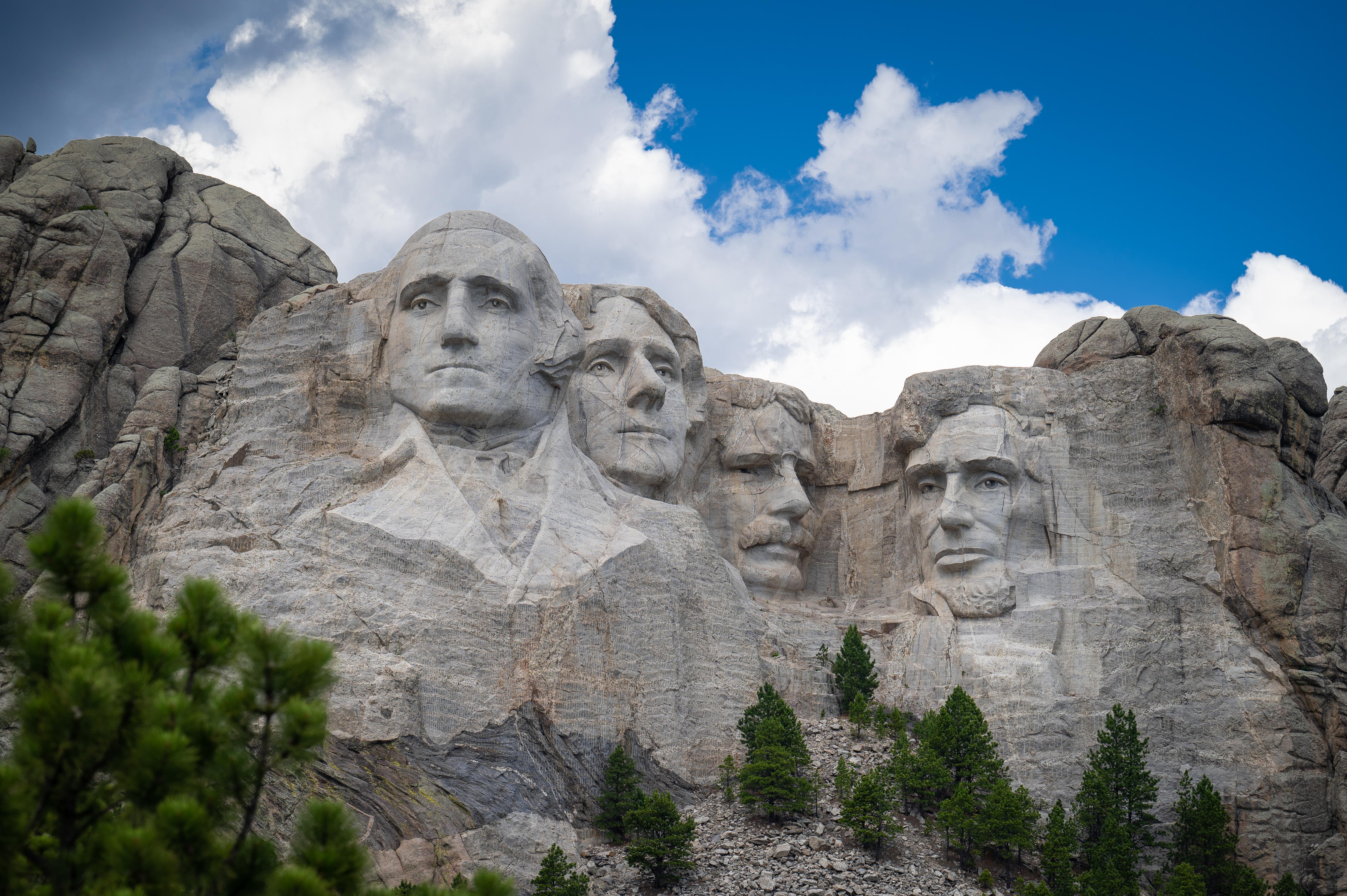
Mount Rushmore National Memorial
National Memorial
Majestic figures of George Washington, Thomas Jefferson, Theodore Roosevelt and Abraham Lincoln, surrounded by the beauty of the Black Hills of South Dakota, tell the story of the birth, growth, devel...
20 mi from route
~49 min detour
Free
near mile 202.3
Park data from the National Park Service API. Alerts update every 2 hours.
More Details
What kind of drive is this?
Expect a turn-heavy local drive rather than a monotonous interstate cruise, as this route features zero percent highway usage. You will be navigating secondary roads that demand your full attention and keep you engaged throughout the 181.8-mile transit. The road's personality is defined by its rural layout, requiring you to navigate various turns as you move through the Great Plains landscape. Because this is not a high-speed expressway, the pace remains steady and functional, reflecting the character of local transit in this part of South Dakota.
97% highway — fuel and pacing are the main things to plan.
20 navigation steps total — most of the decisions cluster near the start and finish.
Longest single stretch: 85.5 mi on State Highway 73.
How Hard Is This Drive?
3/10
This is a straightforward highway drive that stays mostly on State Highway 73 and SD Highway 34. There are only a few real navigation decisions along the way. The trickiest moment comes around 0.4 miles in near US 12; SD 73 / 10th Street West.
Driving Effort3/10
Easy - simple navigation with a manageable amount of wheel time
Balances navigation complexity with total wheel time.
This is a straightforward 4h 31m drive. You will face about 10 decision points, but nothing that requires special attention if you follow navigation.
Where does it get tricky?
The main spots that need attention: at 0.4 miles (US 12; SD 73 / 10th Street West): Navigation decision point; at 65.3 miles (US 212; SD 73): Navigation decision point; at 96.6 miles (SD 34 / SD Highway 34): Navigation decision point.
The longest stretch is about 85.5 miles on State Highway 73. The full list of main roads is in the Roads section above.
Yes — we found about 6 rest areas or service plazas within a short detour of the route (from OpenStreetMap). See the Rest Stops tab under Nearby Places for locations and mile markers. Plan to stretch, use the bathroom, and top off fluids every 2–3 hours on longer drives.
Yes, with realistic expectations. Build in a stop roughly every 2 hours, have snacks and activities ready, and check the Nearby Places tabs for kid-friendly stops along the way.
Mostly yes along the main roads, but rural stretches through SD can have sparse or no coverage. Before you leave, download offline Google Maps or Apple Maps for the route, and consider downloading music or podcasts instead of streaming. If you depend on data for navigation, keep a paper backup of the turn-by-turn directions.
The main spots that need attention: at 0.4 miles (US 12; SD 73 / 10th Street West): Navigation decision point; at 65.3 miles (US 212; SD 73): Navigation decision point; at 96.6 miles (SD 34 / SD Highway 34): Navigation decision point.
Yes — Mount Rushmore National Memorial. See the National Parks section for detour distances and tips on detours.
Possible but tiring. At 4.5 hours each way, an in-and-out day trip would put you behind the wheel for 9.1 hours — manageable with a long break at Box Elder, SD, but most travelers stay overnight.