This 237.5-mile drive from Blue Ridge, Virginia, to Chesapeake, Virginia, will take you about 5 hours and 11 minutes to complete. It's a manageable trip, easily doable in a single day, with an estimated fuel cost of around $38. You'll primarily be traveling on US 460 and Patrick Henry Highway, with a highway share of 44%. This route offers a mixed driving experience as you journey through the Southeast region of Virginia. With only one recommended stop, you can decide to push through or take your time depending on your preference.
Trip Pace
Same-day drive is realistic
A same-day return is possible, but it will make for a full day on the road.
Break Rhythm
1 planned break
Plan on a short reset every 3 to 4 hours to stay fresh behind the wheel.
Midpoint
118.7 miles from Blue Ridge, VA
A natural place for your longest stop of the day
, about 2h 30m into the drive
.
Main Roads
Road
Distance
Duration
US 460
79.8 mi
1h 39m
Patrick Henry Highway
17.2 mi
21m
West Lynchburg Salem Turnpike
14.6 mi
18m
James River Drive
14.6 mi
19m
Hull Street Road
13.7 mi
19m
Colonial Trail West
13.3 mi
15m
World War II Veterans Memorial Highway
12.1 mi
14m
Old Stage Highway
12 mi
15m
Longest stretch:
US 460
— 79.8 mi, about 1h 39m
Traffic on I-95
Hour-of-day weekday pattern from 4 FHWA count stations on your route.
Peak
4 PM
~4,933 veh/hr typical
Quietest
2 AM
~549 veh/hr
Peak-to-quiet ratio
9×
busier at peak than in the quiet hours
12a6anoon6p11p
Averaged across 52 weeks of 2023 FHWA Travel Monitoring Analysis System data. Weekday hours only (Mon–Fri).
Turn-by-Turn Driving Directions
Step-by-step road directions between Blue Ridge, VA and Chesapeake, VA.
1
Start on US 221; US 460
0.2 mi·20 sec·Blue Ridge Boulevard
2
Continue on US 221; US 460
0.9 mi·1 min·Blue Ridge Boulevard
3
Continue on US 221; US 460
15 mi·18 min·West Lynchburg Salem Turnpike
4
Continue on US 221; US 460
0.6 mi·42 sec·Blue Ridge Avenue
5
Keep slight right at fork onto US 460
80 mi·1 hr 39 min·US 460
Toward US 460 EastUse the straight lane.
6
Turn left onto VA 307
9.3 mi·12 min·Holly Farms Road
7
Turn left onto US 360
17 mi·21 min·Patrick Henry Highway
8
Continue on US 360
14 mi·19 min·Hull Street Road
Use the straight lane.
9
Turn right onto SR 754
0.9 mi·1 min·Commonwealth Centre Parkway
Use the right lane.
10
Take the ramp
62 ft·1 sec
11
Keep slight right at fork
0.3 mi·40 sec
Toward VA 288 SouthUse the slight right lane.
12
Merge onto VA 288
12 mi·14 min·World War II Veterans Memorial Highway
13
Keep slight right at fork
0.3 mi·37 sec
Toward I 95 South: PetersburgUse the slight right lane.
14
Merge onto I 95
1.5 mi·1 min·Richmond-Petersburg Turnpike
15
Take the exit
0.3 mi·38 sec
Exit 61AToward VA 10 East: HopewellUse the right lane.
16
Continue on VA 10
6.8 mi·10 min·West Hundred Road
Use the left / uturn lanes.
17
Continue on VA 10
2.9 mi·4 min·West Randolph Road
18
Continue on VA 10; VA 156 BUS
15 mi·19 min·James River Drive
19
Continue on VA 10
13 mi·15 min·Colonial Trail West
20
At end of road, turn left onto VA 10; VA 31
1.0 mi·1 min·Rolfe Highway
21
Take the exit
149 ft·6 sec
22
Merge onto VA 10
9.8 mi·11 min·Colonial Trail East
23
Continue on VA 10
12 mi·15 min·Old Stage Highway
Use the left lane.
24
Keep slight left at fork onto US 258
2.8 mi·3 min·Brewers Neck Boulevard
25
Take the exit
0.1 mi·19 sec
26
Merge onto US 17
2.3 mi·3 min·Carrollton Boulevard
27
Continue on US 17
6.2 mi·10 min·Bridge Road
Use the left lane.
28
Keep slight right at fork onto VA 164
7.4 mi·9 min·Western Freeway
Use the slight right lane.
29
Merge onto US 58; VA 164
0.7 mi·46 sec·Martin Luther King Freeway
30
Take the exit
0.3 mi·35 sec
Toward VA 141 South: Downtown PortsmouthUse the right lane.
31
Turn straight onto US 58
0.9 mi·1 min·London Boulevard
32
Turn right onto Elm Avenue
2.4 mi·4 min·Elm Avenue
Use the straight / left / right lanes.
33
Continue on VA 337
1.1 mi·2 min·South Norfolk Jordan Bridge
34
Turn straight onto VA 337
0.7 mi·1 min·Poindexter Street
Use the straight lane.
35
Turn left onto D Street
412 ft·18 sec·D Street
36
Arrive at destination
D Street
Trip Plan
For this 5-hour journey, starting in the morning is a good idea, allowing you to arrive in Chesapeake with daylight to spare. With only one suggested stop and a fuel cost of about $38, you have flexibility in pacing. Keep an eye on your fuel gauge, especially during the longest stretch of 79.8 miles on US 460, to ensure you don't need to search for a station unexpectedly. This route is well-suited for a single-day trip, but if you prefer a more relaxed pace, consider breaking it up with an overnight stay.
Morning Departure
An early start around 7-8 AM gets you there with plenty of daylight left.
Evening Departure
A late afternoon start means arriving after dark. Morning is better.
You can normally do this drive in one day.
Plan roughly 1 meaningful break for fuel, food, and rest.
The halfway point lands around 118.7 miles from Blue Ridge, VA, or about 2h 30m into the drive.
The longest continuous stretch on this route runs about 79.8 miles.
This is a comfortable same-day trip.
Departure
Before you leave
Start with fuel, water, and navigation already sorted so the first hour feels easy.
First stop
Around 52 miles or 1h 5m in
Use this first pause for coffee, a restroom break, and a quick traffic check ahead.
Halfway reset
Around 118.7 miles or 2h 30m in
This is the best place for your longest stop, a real meal, and a full fuel check.
Final approach
Final hour starts around 4h 10m
Traffic, exits, and arrival timing usually matter more near Chesapeake, VA than in the middle of the route.
Before You Leave
+
Open the route before leaving Blue Ridge, VA so your first major turns are already loaded.
+
Leave with enough water and a charging cable within reach, not packed away.
+
Check your fuel range against the first long segment, especially if you are starting outside city service areas.
Day 1
Settle into the route from Blue Ridge, VA
This is one driving day of about 237.5 miles and 5h 11m.
Your first comfortable stop window is around 52 miles from Blue Ridge, VA.
This route can stay practical as a one-day drive if traffic stays reasonable.
Plan about 1 real break rather than only quick fuel stops.
The longest stretch is on US 460 for about 79.8 miles.
Where to Stop
Rest stops, refuel points, and overnight suggestions along this route.
Place data sourced from public business listings. Hours and availability may vary.
Heads-up: tricky spots
5 of 20
5 decision points cluster between mile 16.3 and 151.5 — GPS handles the exact turns, but know they're coming. Your lane choice matters more than the turn itself.
7
16.3 mi into trip|~21m in|US 460
Keep slight right at fork onto US 460 toward US 460 East
Highway fork - watch signs carefully. Lane positioning matters here
Use the straight lane.
Toward US 460 East
6
136.4 mi into trip|~2h 55m in|SR 754 / Commonwealth Centre Parkway
Turn right onto SR 754 / Commonwealth Centre Parkway
Lane positioning matters here
Use the right lane.
8
137.3 mi into trip|~2h 57m in
Keep slight right at fork toward VA 288 South
Highway fork - watch signs carefully. Lane positioning matters here
Use the slight right lane.
Toward VA 288 South
7
149.8 mi into trip|~3h 11m in
Keep slight right at fork toward I 95 South: Petersburg
Highway fork - watch signs carefully. Lane positioning matters here
Use the slight right lane.
Toward I 95 South: Petersburg
7
151.5 mi into trip|~3h 14m in
Take the exit toward VA 10 East: Hopewell
Exit ramp - move to the correct lane early. Lane positioning matters here
Use the right lane.
Exit 61A
Toward VA 10 East: Hopewell
Fuel & Cost
Regular Gas
$35.06 one way
$70.13 round trip
$3.75/gal25.4 MPG avg83 kg CO2
Fuel Type
$/gal
One Way
Round Trip
midgrade
$4.12
$38.53
$77.07
premium
$4.49
$42.00
$84.00
diesel
$4.80
$44.84
$89.69
Estimated Tolls: $1.12
West Lynchburg Salem Turnpike
(14.6 mi)$1.02
Richmond-Petersburg Turnpike
(1.5 mi)$0.10
Toll estimates based on average 2024-2025 rates. EZ-Pass/SunPass discounts may lower the actual cost.
Estimated Trip Cost (one way, 1 person)
Fuel
$35
Tolls
$1
Meals
$25–$50
Total
$61–$86
Rough estimate based on US averages. Hotel $80–$140/night, meals $25–$50/day.
Estimated CO2 emission: 83.1 kg one way.
Prices: EIA weekly data, 2026-07-13.
Driving Electric?
About $25 in charging
· 0 stops
· 66% less CO2
Vehicle Type
kWh
Stops
DC Fast
Home Charge
Average EV
71.3
0
$24.94
$11.40
Efficient EV
59.4
0
$20.78
$9.50
EV Truck/SUV
95
1
$33.25
$15.20
Gas CO2
83 kg
EV CO2
28 kg (66% less)
Plan for 0 charging stops, roughly every 270 miles. Allow 25-40 minutes per stop at a DC fast charger.
DC fast charging avg $0.35/kWh. Home charging avg $0.16/kWh. US grid CO2: 0.39 kg/kWh.
Travel Intel
Current conditions at both ends of the drive.
Forecast as of Jul 18, 2026
Origin
Blue Ridge, VA
Morning
in Blue Ridge on Monday
Local time
6:46 AM
EDT
Current temp
90°F
Partly Sunny then Scattered Showers And Thunderstorms
W 9 mph60% chanceLive forecast
Heat Advisory
Heat Advisory issued July 18 at 9:28AM EDT until July 18 at 8:00PM EDT by NWS Wakefield VA
Heat Advisory
Heat Advisory issued July 18 at 9:28AM EDT until July 18 at 8:00PM EDT by NWS Wakefield VA
Destination
Chesapeake, VA
Morning
in Chesapeake on Monday
Local time
6:46 AM
EDT
Current temp
97°F
Mostly Sunny
SW 9 to 13 mph13% chanceLive forecast
Heat Advisory
Heat Advisory issued July 18 at 9:28AM EDT until July 18 at 8:00PM EDT by NWS Wakefield VA
Heat Advisory
Heat Advisory issued July 18 at 9:28AM EDT until July 18 at 8:00PM EDT by NWS Wakefield VA
Seasonal Notes
Summer travel usually means heavier construction, hotter rest stops, and busier weekend traffic around major cities.
Winter travel shortens daylight, so a route that looks manageable on paper can feel much longer after dark.
Holiday weekends tend to make both departure and arrival windows slower than the raw route time suggests.
Time zone
Same local time
Origin and destination are on the same clock, so arrival timing is easier to judge at a glance.
Temperature spread
7 degrees warmer at arrival
A meaningful temperature swing is a good cue to rethink layers, water, and how soon you want to arrive.
Road read
5h 11m on the road
An early start around 7-8 AM gets you there with plenty of daylight left.
Weather data from the National Weather Service. Conditions may change; check closer to your travel date.
National Parks Near This Route
Worth a detour if your schedule allows.
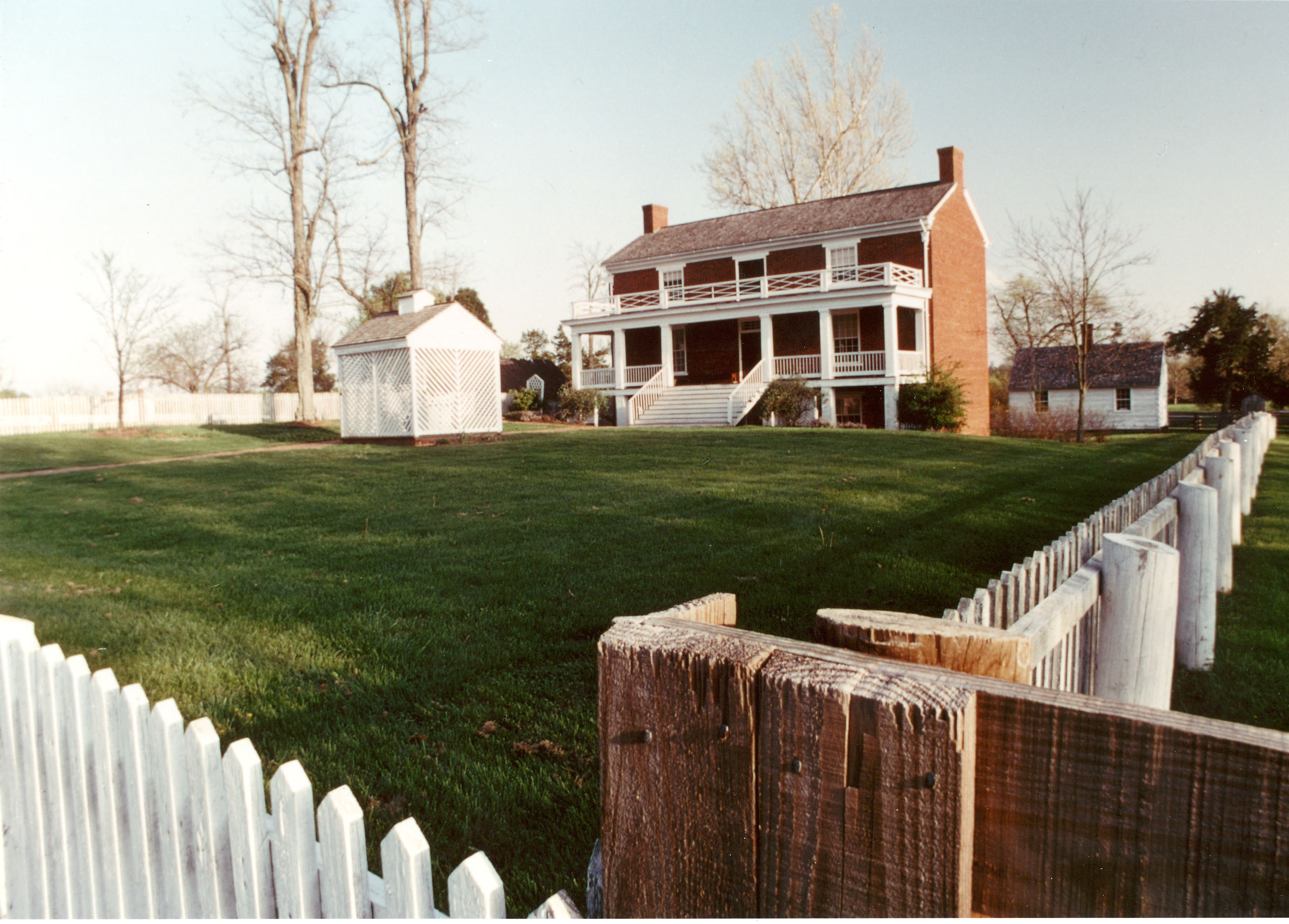
Appomattox Court House National Historical Park
National Historical Park
On April 9, 1865, the surrender of the Army of Northern Virginia in the McLean House in the village of Appomattox Court House, Virginia signaled the effective end of the nation's largest war. Question...
4 mi from route
~11 min detour
Free
near mile 65.5
On May 13, 1607, Jamestown was established as the first permanent English settlement in North America. Three cultures came together – European, Virginia Indian and African–to create a new society that...
10 mi from route
~26 min detour
$15
near mile 196.5
Fort Monroe's story spans from prehistory to the 2000s. Kecoughtan Indians occupied Old Point Comfort before the arrival of English colonists. The first enslaved Africans arrived in 1619. Those escapi...
11 mi from route
~27 min detour
Free
near mile 229.3
Two hundred ninety-two days, eight offensives, over 70,000 casualties, U. S. Colored Troops, and the decline of Gen. Lee's Army of Northern Virginia all describe the Siege of Petersburg. U.S. forces c...
13 mi from route
~33 min detour
Free
near mile 155.6
Booker T. Washington was born a slave in April 1856 on the 207-acre farm of James Burroughs. After the Civil War, Washington became the first principal of Tuskegee Normal and Industrial School. Later...
17 mi from route
~43 min detour
Free
near mile 8.2
Park data from the National Park Service API. Alerts update every 2 hours.
More Details
What kind of drive is this?
The drive features a mixed profile, meaning you'll encounter a variety of road types. While 44% of the route is on highways, you'll also navigate through sections that feel more like traditional roads. The longest uninterrupted stretch is 79.8 miles along US 460, offering a good period of consistent travel. Expect the character of the drive to shift as you progress through different parts of Virginia, moving from potentially more rural or scenic segments to busier thoroughfares as you approach Chesapeake.
44% highway, the rest on surface roads — varied driving throughout.
36 navigation steps total — most of the decisions cluster near the start and finish.
Longest single stretch: 79.8 mi on US 460.
How Hard Is This Drive?
10/10
This route mixes highway mileage with some local-road sections near the start or finish. This route has several spots where lane changes, forks, or exits need your full attention. The trickiest moment comes around 16.3 miles in near US 460.
Driving Effort10/10
High effort - long or complex enough to need steady focus all day
Balances navigation complexity with total wheel time.
This is a demanding drive. With 20 significant decision points across 237.5 miles, you will need to stay alert - especially through interchange areas and urban stretches. Consider splitting it into segments if you are not comfortable with fast highway navigation.
Where does it get tricky?
The main spots that need attention: at 16.3 miles (US 460): Highway fork - watch signs carefully. Lane positioning matters here; at 136.4 miles (SR 754 / Commonwealth Centre Parkway): Lane positioning matters here; at 137.3 miles: Highway fork - watch signs carefully. Lane positioning matters here.
Chesapeake is a town of 245,000 people (2019) in the Hampton Roads region of Eastern Virginia. Chesapeake is a diverse city in which a few urban areas are located; it also has many square miles of protected farmland, forests, and wetlands, including a substantial portion of the Great Dismal Swamp National Wildlife Refuge.
Top landmarks
•Dismal Swamp Canal — canal in Virginia, United States of America
•Albemarle and Chesapeake Canal — canal in Chesapeake, Virginia
•South Norfolk Historic District — historic district in Virginia, United States
Doable as a same-day drive at 5h 11m. Total distance: 237.5 miles.
Family Friendly
Moderate complexity with 1 natural rest stops along the way.
Solo Traveler
5h 11m drive, comfortable solo distance.
Scenic Drive
Mixed highway & surface route profile with national parks nearby.
Frequently Asked Questions
The longest stretch is about 79.8 miles on US 460. The full list of main roads is in the Roads section above.
Expect about $1.12 in tolls one way, starting with West Lynchburg Salem Turnpike. Most Northeast and Midwest toll agencies accept E-ZPass; in the West and Texas, transponders like TxTag or FasTrak apply. If you do not have a transponder, cashless tolling plates will mail a bill to the vehicle's registered address — usually with a surcharge, so a rental-car toll pass is often cheaper than paying by mail.
We did not find dedicated rest areas on this route. For a drive this long, plan bathroom and stretch breaks around gas stations, fast-food stops, or small-town downtowns — check the Nearby Places section for options.
It helps. This route has a higher-than-average number of complex decision points, which get harder in the dark. If the last hour of the trip is on surface roads or mountain grades, aim to arrive at Chesapeake, VA before sunset when you can. Check the Trip Plan for departure windows that land you in daylight.
Only with planning. This is a long drive for kids — consider splitting it into two days rather than pushing through. Plan at least 1 meaningful breaks. Dedicated rest areas are limited, so plan gas or food stops as your bathroom breaks.
The main spots that need attention: at 16.3 miles (US 460): Highway fork - watch signs carefully. Lane positioning matters here; at 136.4 miles (SR 754 / Commonwealth Centre Parkway): Lane positioning matters here; at 137.3 miles: Highway fork - watch signs carefully. Lane positioning matters here.
Yes — Appomattox Court House National Historical Park, Colonial National Historical Park and Fort Monroe National Monument (5 total within detour distance). See the National Parks section for detour distances and tips on detours.
Not recommended in a single day. At 5.2 hours each way, a round trip means 10.4 hours of driving — that is an unsafe level of fatigue for most drivers. Plan at least one night at Chesapeake, VA before the return drive.