Traveling from Zuni Pueblo to Deming covers 281.2 miles of the New Mexico Desert Southwest, typically taking about 6 hours and 30 minutes of drive time. Because this is a highway-focused journey, you can easily complete it in a single day, though it requires steady attention to the road. Expect to set aside roughly $43 for fuel to cover the distance. While the route is straightforward, it is best suited for those who enjoy long stretches of open road. Since you are staying within the same region, the landscape maintains a consistent desert character throughout the trip. Planning for one major stop will help break up the time behind the wheel.
Trip Pace
Same-day drive is realistic
A same-day return is possible, but it will make for a full day on the road.
Break Rhythm
1 planned break
Plan on a short reset every 3 to 4 hours to stay fresh behind the wheel.
Midpoint
140.6 miles from Zuni Pueblo, NM
A natural place for your longest stop of the day
, about 3h 11m into the drive
.
Main Roads
Road
Distance
Duration
US 180
119 mi
2h 51m
AZ 61
42.8 mi
50m
Tom Foy Boulevard
37.9 mi
45m
Springerville-Alpine-State Line Highway
25.8 mi
38m
Holbrook-Springerville Highway
23.8 mi
35m
New Mexico Highway 53
10.2 mi
11m
Silver Heights Boulevard
9.3 mi
17m
Show Low-Springerville-East Highway
4.3 mi
4m
Longest stretch:
US 180
— 119 mi, about 2h 51m
Turn-by-Turn Driving Directions
Step-by-step road directions between Zuni Pueblo, NM and Deming, NM.
1
Start on Twin Buttes Drive
0.1 mi·25 sec·Twin Buttes Drive
2
Turn slight right onto Pincion Street
0.2 mi·44 sec·Pincion Street
3
Turn right onto NM 53
1.4 mi·3 min·New Mexico 53
4
Continue on NM 53
10 mi·11 min·New Mexico Highway 53
5
Continue on AZ 61
43 mi·50 min·AZ 61
6
Turn left onto US 180; US 191
1.6 mi·2 min·White Mountain Drive
7
Continue on US 180; US 191
24 mi·35 min·Holbrook-Springerville Highway
8
At end of road, turn left onto US 60; US 180; US 191
4.3 mi·4 min·Show Low-Springerville-East Highway
9
Turn right onto US 180; US 191
1.9 mi·2 min·Springerville-Alpine-State Line Highway
10
At end of road, turn left onto US 180; US 191
0.2 mi·18 sec·East Central Avenue
11
Turn straight onto US 180; US 191
24 mi·35 min·Springerville-Alpine-State Line Highway
12
Turn left onto US 180
119 mi·2 hr 51 min·US 180
13
Turn left onto NM 90
0.1 mi·10 sec·North Hudson Street
14
Continue on US 180
9.3 mi·17 min·Silver Heights Boulevard
15
Continue on US 180
38 mi·45 min·Tom Foy Boulevard
16
Continue on US 180
4.2 mi·6 min·North Gold Avenue
17
Turn left onto I 10 Bus
442 ft·18 sec·East Pine Street
18
Continue on I 10 Bus
398 ft·14 sec·East Pine Street
19
Arrive at destination
I 10 Bus
Trip Plan
To make the most of your 6-hour and 30-minute excursion, consider departing early in the morning to maximize daylight hours. Since you only have one planned stop along the way, ensure your vehicle is fueled up before hitting the long 119-mile stretch on US 180 to avoid any unnecessary range anxiety. Keep a close eye on your fuel gauge, especially given the $43 estimate for the total trip. Flexibility is your biggest advantage on this route, so feel free to adjust your pace if you encounter unexpected traffic or weather conditions. Most importantly, stay hydrated and keep snacks handy, as services can be sparse between major highway segments.
Morning Departure
Start early — leave by 6-7 AM to arrive at a reasonable hour.
Evening Departure
This is a long drive — plan for a morning departure or consider splitting it into two days.
You can normally do this drive in one day.
Plan roughly 1 meaningful break for fuel, food, and rest.
The halfway point lands around 140.6 miles from Zuni Pueblo, NM, or about 3h 11m into the drive.
The longest continuous stretch on this route runs about 119 miles.
This is a comfortable same-day trip.
Departure
Before you leave
Start with fuel, water, and navigation already sorted so the first hour feels easy.
First stop
Around 62 miles or 1h 17m in
Use this first pause for coffee, a restroom break, and a quick traffic check ahead.
Halfway reset
Around 140.6 miles or 3h 11m in
This is the best place for your longest stop, a real meal, and a full fuel check.
Final approach
Final hour starts around 5h 21m
Traffic, exits, and arrival timing usually matter more near Deming, NM than in the middle of the route.
Before You Leave
+
Open the route before leaving Zuni Pueblo, NM so your first major turns are already loaded.
+
Leave with enough water and a charging cable within reach, not packed away.
+
Check your fuel range against the first long segment, especially if you are starting outside city service areas.
Day 1
Settle into the route from Zuni Pueblo, NM
This is one driving day of about 281.2 miles and 6h 30m.
Your first comfortable stop window is around 62 miles from Zuni Pueblo, NM.
This route can stay practical as a one-day drive if traffic stays reasonable.
Plan about 1 real break rather than only quick fuel stops.
The longest stretch is on US 180 for about 119 miles.
Where to Stop
Rest stops, refuel points, and overnight suggestions along this route.
Place data sourced from public business listings. Hours and availability may vary.
Heads-up: tricky spots
5 of 9
5 decision points cluster between mile 0.1 and 86.3 — GPS handles the exact turns, but know they're coming. Your lane choice matters more than the turn itself.
3
0.1 mi into trip|~0m in|Pincion Street
Turn slight right onto Pincion Street
Navigation decision point
4
0.3 mi into trip|~1m in|NM 53 / New Mexico 53
Turn right onto NM 53 / New Mexico 53
Navigation decision point
4
54.7 mi into trip|~1h 6m in|US 180; US 191 / White Mountain Drive
Turn left onto US 180; US 191 / White Mountain Drive
Navigation decision point
4
80.1 mi into trip|~1h 44m in|US 60; US 180; US 191 / Show Low-Springerville-East Highway
At end of road, turn left onto US 60; US 180; US 191 / Show Low-Springerville-East Highway
Navigation decision point
4
86.3 mi into trip|~1h 52m in|US 180; US 191 / East Central Avenue
At end of road, turn left onto US 180; US 191 / East Central Avenue
Navigation decision point
Fuel & Cost
Regular Gas
$39.04 one way
$78.07 round trip
$3.53/gal25.4 MPG avg98 kg CO2
Fuel Type
$/gal
One Way
Round Trip
midgrade
$3.95
$43.67
$87.35
premium
$4.29
$47.48
$94.97
diesel
$4.80
$53.10
$106.19
No toll roads detected on this route.
Estimated Trip Cost (one way, 1 person)
Fuel
$39
Meals
$25–$50
Total
$64–$89
Rough estimate based on US averages. Hotel $80–$140/night, meals $25–$50/day.
Estimated CO2 emission: 98.4 kg one way.
Prices: EIA weekly data, 2026-07-13.
Driving Electric?
About $30 in charging
· 1 stop
· 66% less CO2
Vehicle Type
kWh
Stops
DC Fast
Home Charge
Average EV
84.4
1
$29.53
$13.50
Efficient EV
70.3
0
$24.61
$11.25
EV Truck/SUV
112.5
1
$39.37
$18.00
Gas CO2
98 kg
EV CO2
33 kg (66% less)
Plan for 1 charging stop. A 30-minute DC fast charge mid-route should be enough to complete the trip comfortably.
DC fast charging avg $0.35/kWh. Home charging avg $0.16/kWh. US grid CO2: 0.39 kg/kWh.
Travel Intel
Current conditions at both ends of the drive.
Forecast as of Jul 18, 2026
Origin
Zuni Pueblo, NM
Late night
in Zuni Pueblo on Sunday
Local time
12:24 AM
MDT
Current temp
57°F
Chance Showers And Thunderstorms then Mostly Cloudy
S 0 to 5 mph51% chanceLive forecast
Dust Storm Warning
Dust Storm Warning issued July 17 at 7:18PM MDT until July 17 at 8:45PM MDT by NWS El Paso Tx/Santa Teresa NM
Flood Watch
Flood Watch issued July 17 at 5:52PM MDT until July 17 at 9:00PM MDT by NWS Albuquerque NM
Destination
Deming, NM
Late night
in Deming on Sunday
Local time
12:24 AM
MDT
Current temp
66°F
Chance Showers And Thunderstorms then Mostly Cloudy
WSW 6 to 12 mph25% chanceLive forecast
Dust Storm Warning
Dust Storm Warning issued July 17 at 7:18PM MDT until July 17 at 8:45PM MDT by NWS El Paso Tx/Santa Teresa NM
Flood Watch
Flood Watch issued July 17 at 5:52PM MDT until July 17 at 9:00PM MDT by NWS Albuquerque NM
Seasonal Notes
Summer travel usually means heavier construction, hotter rest stops, and busier weekend traffic around major cities.
Winter travel shortens daylight, so a route that looks manageable on paper can feel much longer after dark.
Holiday weekends tend to make both departure and arrival windows slower than the raw route time suggests.
Time zone
Same local time
Origin and destination are on the same clock, so arrival timing is easier to judge at a glance.
Temperature spread
9 degrees warmer at arrival
A meaningful temperature swing is a good cue to rethink layers, water, and how soon you want to arrive.
Road read
6h 30m on the road
Start early — leave by 6-7 AM to arrive at a reasonable hour.
Weather data from the National Weather Service. Conditions may change; check closer to your travel date.
National Parks Near This Route
Worth a detour if your schedule allows.
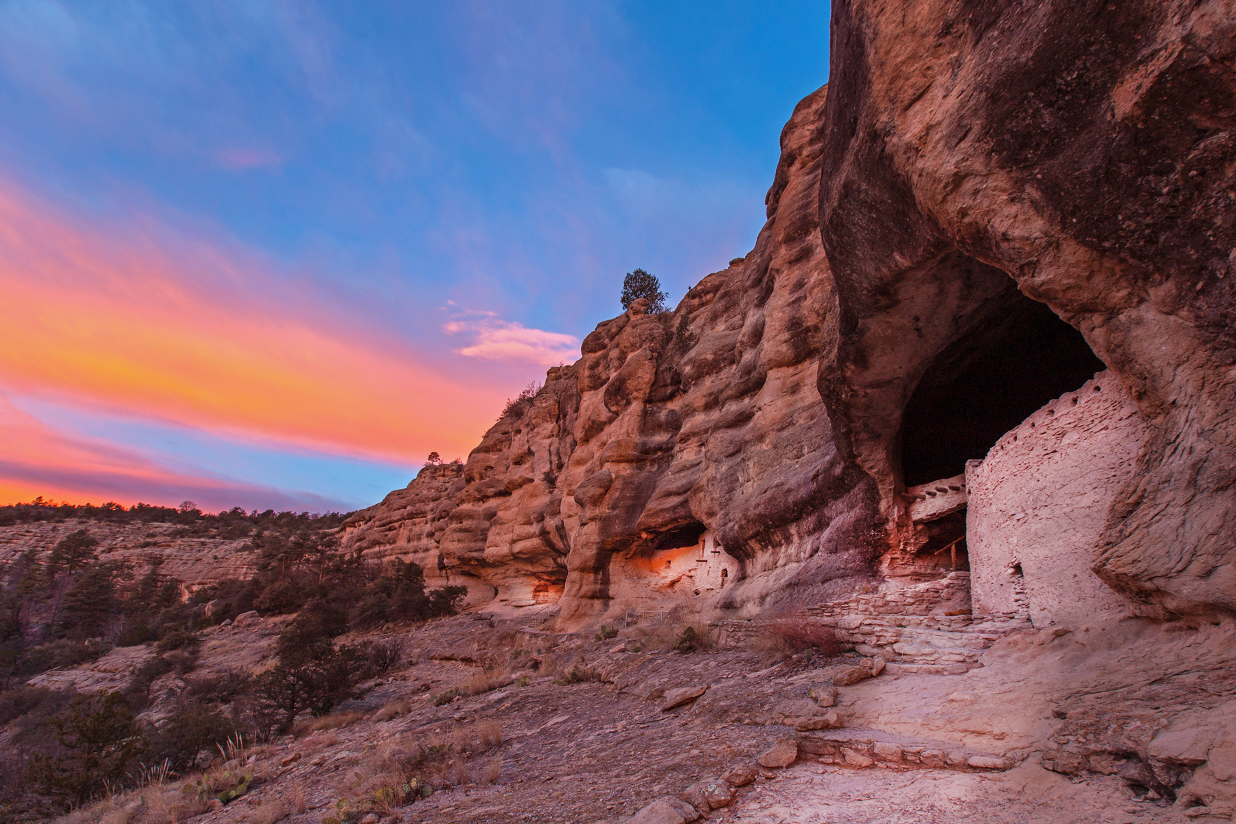
Gila Cliff Dwellings National Monument
National Monument
For thousands of years, groups of nomads used the caves above Cliff Dweller Creek as temporary shelter. In the late 1200s, people of the agricultural Mogollon (Southern Ancestral Pueblo) culture made...
28 mi from route
~70 min detour
Free
near mile 203.6
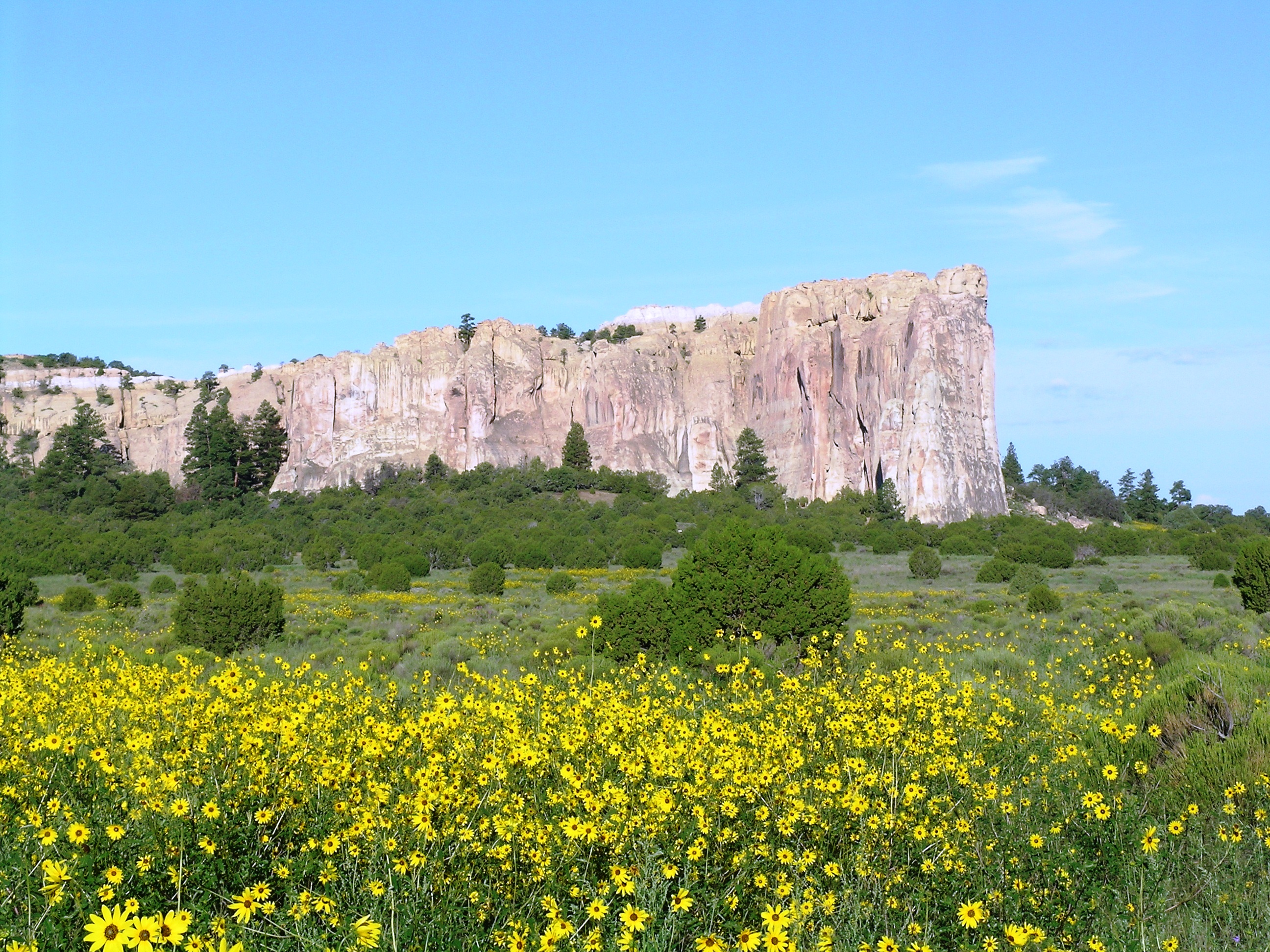
Imagine the refreshment of finding water after days of dusty travel. A reliable waterhole hidden at the base of a sandstone bluff made El Morro (the headland) a popular campsite for hundreds of years....
Park data from the National Park Service API. Alerts update every 2 hours.
More Details
What kind of drive is this?
This trip leans heavily on major thoroughfares, with approximately 61% of your journey spent on highways like US 180, AZ 61, and Tom Foy Boulevard. You will experience a mix of driving conditions, including a significant 119-mile uninterrupted stretch on US 180 that demands focus and preparation. The road personality shifts from rural stretches to more developed local road segments as you approach your destination. Rather than a repetitive interstate grind, you will navigate a variety of road types that keep the drive engaging. Anticipate a steady pace that rewards drivers who prefer consistent highway travel over frequent, winding turns.
61% highway — fuel and pacing are the main things to plan.
19 navigation steps total — most of the decisions cluster near the start and finish.
Longest single stretch: 119 mi on US 180.
How Hard Is This Drive?
3/10
This is a straightforward highway drive that stays mostly on US 180 and AZ 61. There are only a few real navigation decisions along the way. The trickiest moment comes around 0.1 miles in near Pincion Street.
Driving Effort3/10
Easy - simple navigation with a manageable amount of wheel time
Balances navigation complexity with total wheel time.
The route itself is not hard, but at 6h 30m, endurance matters. Plan breaks every 2-3 hours. The 9 decision points are all manageable with basic attention.
Where does it get tricky?
The main spots that need attention: at 0.1 miles (Pincion Street): Navigation decision point; at 0.3 miles (NM 53 / New Mexico 53): Navigation decision point; at 54.7 miles (US 180; US 191 / White Mountain Drive): Navigation decision point.
Elevation Profile
High-altitude sections with notable climbs
7,677 ft4,342 ft
Total Climb
3,658 ft
Total Descent
5,605 ft
Highest Point
7,677 ft
~100.4 mi in
Elevation Range
3,335 ft
Notable High Points
6,493 ft at ~20.1 miles+204 ft prominence
7,677 ft at ~100.4 miles+301 ft prominence
5,216 ft at ~180.7 miles+253 ft prominence
5,728 ft at ~241 miles+97 ft prominence
Detours Along the Way
Tagged by where each one fits in your drive — first break, midpoint, final stretch.
Deming is a small town in the southwestern region of New Mexico, USA. It has attained a quirky sort of fame as the site of the Great American Duck Race, one of those little bits of Americana sometimes encountered in very small towns. Interesting country is nearby for the geologist and hiker.
Top landmarks
•Downtown Deming Historic District — historic district in Deming, New Mexico, United States
•Deming Main Post Office — main post office building for Deming, New Mexico
•Morgan Hall — former city hall and fire station in Deming, New Mexico
The longest stretch is about 119 miles on US 180. The full list of main roads is in the Roads section above.
We did not find dedicated rest areas on this route. For a drive this long, plan bathroom and stretch breaks around gas stations, fast-food stops, or small-town downtowns — check the Nearby Places section for options.
It helps. This is a long drive, so arriving tired and in the dark compounds. If the last hour of the trip is on surface roads or mountain grades, aim to arrive at Deming, NM before sunset when you can. Check the Trip Plan for departure windows that land you in daylight.
Only with planning. This is a long drive for kids — consider splitting it into two days rather than pushing through. Plan at least 1 meaningful breaks. Dedicated rest areas are limited, so plan gas or food stops as your bathroom breaks.
Mostly yes along the main roads, but rural stretches through NM can have sparse or no coverage. Before you leave, download offline Google Maps or Apple Maps for the route, and consider downloading music or podcasts instead of streaming. If you depend on data for navigation, keep a paper backup of the turn-by-turn directions.
The main spots that need attention: at 0.1 miles (Pincion Street): Navigation decision point; at 0.3 miles (NM 53 / New Mexico 53): Navigation decision point; at 54.7 miles (US 180; US 191 / White Mountain Drive): Navigation decision point.
Yes — Gila Cliff Dwellings National Monument and El Morro National Monument. See the National Parks section for detour distances and tips on detours.
Not recommended in a single day. At 6.5 hours each way, a round trip means 13.0 hours of driving — that is an unsafe level of fatigue for most drivers. Plan at least one night at Deming, NM before the return drive.