Sacramento, CA to Cottonwood, CA is 145.1 miles and takes about 2 hours 39 minutes via Westside Freeway and Cascade Wonderland Highway, with a fuel budget near $33 and enough daylight to finish in a day. This journey stays within the Pacific Coast region, offering a straightforward drive. With an 87% highway share, expect a fairly direct trip. It's a solid option if you're looking for a quick transit between these two California points, easily managed in a single day.
Trip Pace
Same-day drive is realistic
A same-day return is realistic if you keep stops short.
Break Rhythm
1 planned break
A short stop every 2 to 3 hours is enough for this drive.
Midpoint
72.5 miles from Sacramento, CA
A natural place for your longest stop of the day
, about 1h 19m into the drive
.
Main Roads
Road
Distance
Duration
Westside Freeway
126.6 mi
2h 16m
Cascade Wonderland Highway
15.8 mi
16m
Main Street
1.2 mi
2m
I Street
0.4 mi
<1m
10th Street
<0.1 mi
<1m
J Street
<0.1 mi
<1m
9th Street
<0.1 mi
<1m
1st Street
<0.1 mi
<1m
Longest stretch:
Westside Freeway
— 126.6 mi, about 2h 16m
Turn-by-Turn Driving Directions
Step-by-step road directions between Sacramento, CA and Cottonwood, CA.
1
Start on 9th Street
348 ft·16 sec·9th Street
2
Turn left onto J Street
406 ft·14 sec·J Street
3
Turn left onto 10th Street
419 ft·18 sec·10th Street
4
Turn left onto I Street
0.4 mi·44 sec·I Street
Use the left lane.
5
Take the ramp
0.4 mi·55 sec
Toward I 5 North, CA 99 North: Redding, Yuba CityUse the straight / slight right lanes.
6
Merge onto I 5
5.6 mi·6 min·Westside Freeway
Use the straight / slight right lanes.
7
Keep slight left at fork onto I 5
121 mi·2 hr 10 min·Westside Freeway
Use the straight / slight right lanes.
8
Continue on I 5
16 mi·16 min·Cascade Wonderland Highway
9
Take the exit
0.3 mi·32 sec
Toward Bowman Road, Cottonwood
10
Continue on CR A5
1.2 mi·2 min·Main Street
11
Turn right onto 1st Street
64 ft·1 sec·1st Street
12
Arrive at destination
1st Street
Trip Plan
Given this is a relatively short, 1-day trip of just over 2.5 hours, you have the flexibility to leave when you wish. Planning to depart earlier in the day will give you ample daylight for the drive and any brief stops. Keep an eye on fuel levels, especially before embarking on the 126.6-mile stretch on the Westside Freeway, as services might be less frequent during that segment. The single recommended stop is a good opportunity to stretch your legs and refuel.
Morning Departure
Leave by 9 AM and you'll arrive before lunch.
Evening Departure
Even a 4 PM departure gets you there before dark in summer.
You can normally do this drive in one day.
Plan roughly 1 meaningful break for fuel, food, and rest.
The halfway point lands around 72.5 miles from Sacramento, CA, or about 1h 19m into the drive.
The longest continuous stretch on this route runs about 126.6 miles.
This is a comfortable same-day trip.
Departure
Before you leave
Start with fuel, water, and navigation already sorted so the first hour feels easy.
First stop
Around 32 miles or 36m in
Use this first pause for coffee, a restroom break, and a quick traffic check ahead.
Halfway reset
Around 72.5 miles or 1h 19m in
This is the best place for your longest stop, a real meal, and a full fuel check.
Final approach
Final hour starts around 2h 9m
Traffic, exits, and arrival timing usually matter more near Cottonwood, CA than in the middle of the route.
Before You Leave
+
Open the route before leaving Sacramento, CA so your first major turns are already loaded.
+
Leave with enough water and a charging cable within reach, not packed away.
+
Check your fuel range against the first long segment, especially if you are starting outside city service areas.
Day 1
Settle into the route from Sacramento, CA
This is one driving day of about 145.1 miles and 2h 39m.
Your first comfortable stop window is around 32 miles from Sacramento, CA.
This route can stay practical as a one-day drive if traffic stays reasonable.
Plan about 1 real break rather than only quick fuel stops.
The longest stretch is on Westside Freeway for about 126.6 miles.
Where to Stop
Rest stops, refuel points, and overnight suggestions along this route.
The midpoint is around 72.5 miles from Sacramento, CA, which is a good place for a longer meal and fuel stop.
Before the longest stretch
Fuel check
Top up before Westside Freeway if your tank is already low. That segment runs about 126.6 miles.
These stop ideas are pacing suggestions — the exact town or exit can change with traffic, hotel plans, and fuel range.
Heads-up: tricky spots
5 of 8
5 decision points cluster between mile 0.1 and 6.7 — GPS handles the exact turns, but know they're coming. Your lane choice matters more than the turn itself.
5
0.1 mi into trip|~0m in|J Street
Turn left onto J Street
Navigation decision point
5
0.1 mi into trip|~0m in|10th Street
Turn left onto 10th Street
Navigation decision point
6
0.2 mi into trip|~0m in|I Street
Turn left onto I Street
Lane positioning matters here
Use the left lane.
6
0.6 mi into trip|~1m in
Take the ramp toward I 5 North, CA 99 North: Redding, Yuba City
Lane positioning matters here. Multiple destination signs - pick the right one
Use the straight / slight right lanes.
Toward I 5 North, CA 99 North: Redding, Yuba Ci...
6
6.7 mi into trip|~9m in|I 5 / Westside Freeway
Keep slight left at fork onto I 5 / Westside Freeway
Highway fork - watch signs carefully. Lane positioning matters here
Use the straight / slight right lanes.
Fuel & Cost
Regular Gas
$33.35 one way
$66.70 round trip
$5.84/gal25.4 MPG avg51 kg CO2
Fuel Type
$/gal
One Way
Round Trip
midgrade
$6.02
$34.37
$68.73
premium
$6.18
$35.29
$70.57
diesel
$5.61
$32.04
$64.07
No toll roads detected on this route.
Estimated Trip Cost (one way, 1 person)
Fuel
$33
Meals
$25–$50
Total
$58–$83
Rough estimate based on US averages. Hotel $80–$140/night, meals $25–$50/day.
Estimated CO2 emission: 50.8 kg one way.
Prices: EIA weekly data, 2026-04-13.
Driving Electric?
About $15 in charging
· 0 stops
· 67% less CO2
Vehicle Type
kWh
Stops
DC Fast
Home Charge
Average EV
43.5
0
$15.24
$6.96
Efficient EV
36.3
0
$12.70
$5.80
EV Truck/SUV
58
0
$20.31
$9.29
Gas CO2
51 kg
EV CO2
17 kg (67% less)
This trip is well within single-charge range for most EVs. No charging stops needed if you start fully charged.
DC fast charging avg $0.35/kWh. Home charging avg $0.16/kWh. US grid CO2: 0.39 kg/kWh.
Travel Intel
Current conditions at both ends of the drive.
Forecast as of Apr 16, 2026
Origin
Sacramento, CA
Late night
in Sacramento on Sunday
Local time
5:09 AM
PDT
Current temp
68°F
Sunny
NNW 13 to 18 mph0% chanceLive forecast
Freeze Warning
Freeze Warning issued April 16 at 10:43AM PDT until April 17 at 11:00AM PDT by NWS Medford OR
Wind Advisory
Wind Advisory issued April 16 at 10:32AM PDT until April 17 at 11:00AM PDT by NWS Hanford CA
Destination
Cottonwood, CA
Late night
in Cottonwood on Sunday
Local time
5:09 AM
PDT
Current temp
45°F
Unavailable
Live forecast
Seasonal Notes
Summer travel usually means heavier construction, hotter rest stops, and busier weekend traffic around major cities.
Winter travel shortens daylight, so a route that looks manageable on paper can feel much longer after dark.
Holiday weekends tend to make both departure and arrival windows slower than the raw route time suggests.
Time zone
Same local time
Origin and destination are on the same clock, so arrival timing is easier to judge at a glance.
Temperature spread
23 degrees cooler at arrival
A meaningful temperature swing is a good cue to rethink layers, water, and how soon you want to arrive.
Road read
2h 39m on the road
The weather snapshot is not static. If you are leaving later, give both cities one more quick forecast check before departure.
Weather data from the National Weather Service. Conditions may change; check closer to your travel date.
National Parks Near This Route
Worth a detour if your schedule allows.
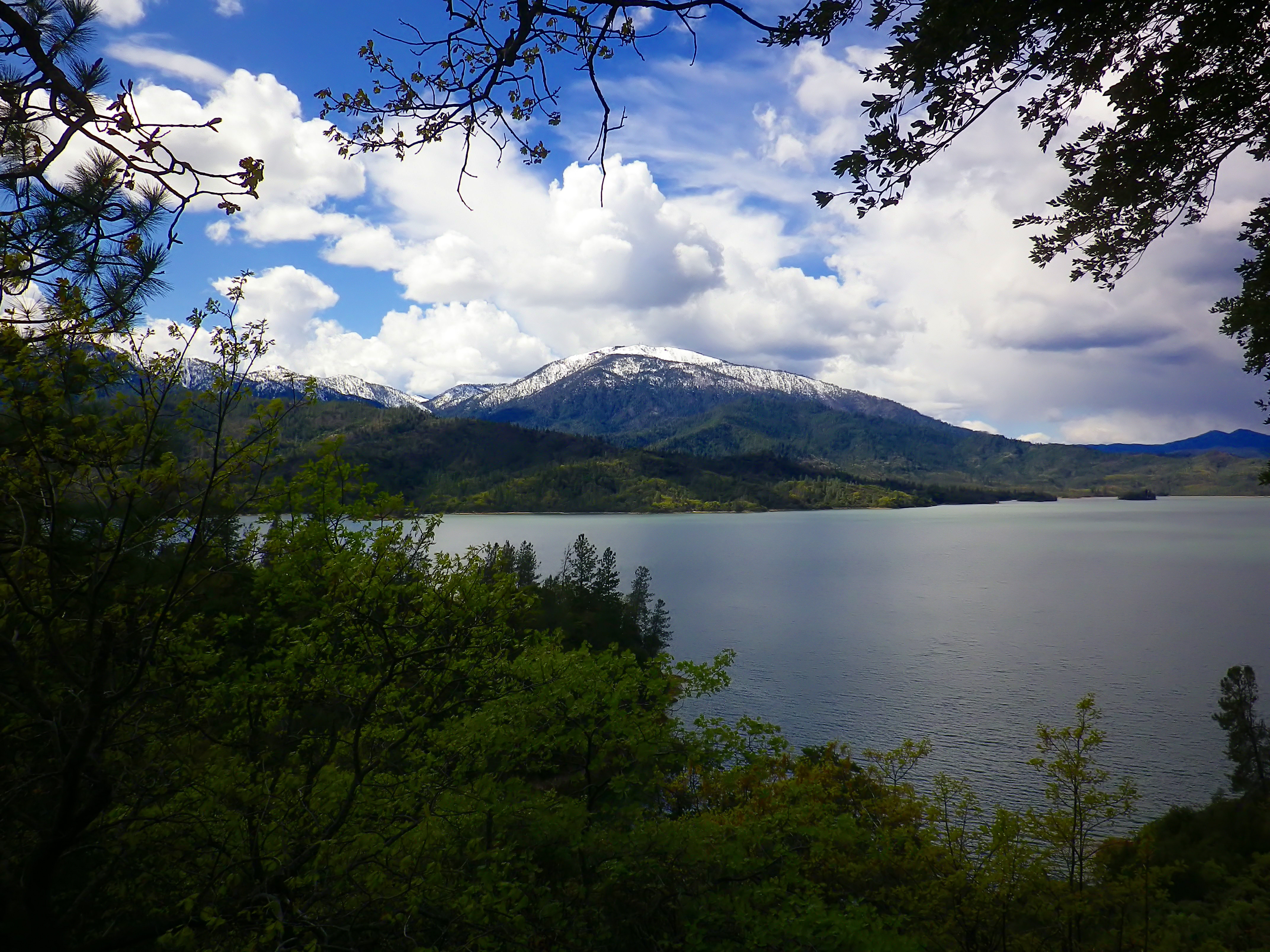
Whiskeytown National Recreation Area
National Recreation Area
Whiskeytown Lake’s crystal-clear waters are iconic, but this 42,000-acre National Recreation Area offers much more. Explore waterfalls, hike rugged trails, uncover Gold Rush history, and witness the r...
23 mi from route
~58 min detour
$15
near mile 145.1
Park data from the National Park Service API. Alerts update every 2 hours.
More Details
What kind of drive is this?
This route is predominantly highway-focused, with 87% of it being on major roads like the Westside Freeway. You'll experience a long, uninterrupted stretch of 126.6 miles on the Westside Freeway, making for a consistent driving pace. The Cascade Wonderland Highway also contributes to the highway feel. Expect a drive where the focus is on covering distance efficiently, rather than a winding, scenic exploration.
87% highway — fuel and pacing are the main things to plan.
12 navigation steps total — most of the decisions cluster near the start and finish.
Longest single stretch: 126.6 mi on Westside Freeway.
How Hard Is This Drive?
4/10
This is a straightforward highway drive that stays mostly on Westside Freeway and Cascade Wonderland Highway. There are only a few real navigation decisions along the way. The trickiest moment comes around 0.1 miles in near J Street.
Driving Effort4/10
Easy - simple navigation with a manageable amount of wheel time
Balances navigation complexity with total wheel time.
This is a straightforward 2h 39m drive. You will face about 8 decision points, but nothing that requires special attention if you follow navigation.
Where does it get tricky?
The main spots that need attention: at 0.1 miles (J Street): Navigation decision point; at 0.1 miles (10th Street): Navigation decision point; at 0.2 miles (I Street): Lane positioning matters here.
Sacramento is the state capital of California in the United States. It is the regional center for the Greater Sacramento metropolitan area, which dominates much of the surrounding Sacramento Valley and stretches into parts of Gold Country.
Sacramento is the oldest incorporated city in California, settled between the confluences of the Sacramento and American rivers. The city has been the site of many important historic events that have shaped California and U.S. history, most notably the California Gold Rush and location of the original terminus of the First Transcontinental Railroad. Much of this historical legacy has been preserved, especially in the historic Old Sacramento district, where buildings and railroads from that era continue to attract visitors.
However, Sacramento is not a city that is stuck in the past. As the capital of the most populous U.S.
Top landmarks
•California State Capitol — state capitol building of the U.S. state of California
•Crocker Art Museum — art museum in Sacramento, California
•Sacramento Valley Station — main railroad and light rail station in Sacramento, California
The longest stretch is about 126.6 miles on Westside Freeway. The full list of main roads is in the Roads section above.
Yes, with realistic expectations. Build in a stop roughly every 2 hours, have snacks and activities ready, and check the Nearby Places tabs for kid-friendly stops along the way.
The main spots that need attention: at 0.1 miles (J Street): Navigation decision point; at 0.1 miles (10th Street): Navigation decision point; at 0.2 miles (I Street): Lane positioning matters here.
Yes — Whiskeytown National Recreation Area. See the National Parks section for detour distances and tips on detours.
Yes. A round trip is manageable in a single day if you plan a break at Cottonwood, CA before heading back.