Rest Area
0 mi from route
Compiled and reviewed by the US Trip Planner planning team at COD Solutions Oy · Last reviewed Jul 19, 2026 · Editorial standards
Drive Time
4h 48m
Distance
246.2 mi
396 km
Drive Score
9/10
Great drive
Same Day?
Yes, doable
Fuel Cost
$36
one way
EV Charging
Unknown
Estimated drive times based on typical traffic patterns. Actual times may vary with weather, construction, and real-time conditions.

Paris, TN
Wikimedia Commons
This 251.3-mile drive from Paris, TN, to East Chattanooga, TN, is estimated to take about 4 hours and 4 minutes, making it a feasible one-day trip. You'll navigate primarily on local roads, with a 0% highway share, suggesting a more relaxed pace. The estimated fuel cost for this journey is around $38. This route is characterized by frequent turns, so be prepared for an engaging drive through the Southeast region of Tennessee. With just one recommended stop, you can easily complete this trip in a single day.
Trip Pace
Same-day drive is realistic
A same-day return is possible, but it will make for a full day on the road.
Break Rhythm
1 planned break
Plan on a short reset every 3 to 4 hours to stay fresh behind the wheel.
Midpoint
123.1 miles from Paris, TN
A natural place for your longest stop of the day , about 2h 27m into the drive .
| Road | Distance | Duration |
|---|---|---|
| I 24 | 167.4 mi | 3h 6m |
| Main Street | 28.1 mi | 34m |
| Austin Peay Memorial Highway | 25.1 mi | 28m |
| Ashland City Road | 5.6 mi | 6m |
| West Wood Street | 3.9 mi | 5m |
| TN 76 | 3.1 mi | 3m |
| North Riverside Drive | 2.4 mi | 4m |
| Donelson Parkway | 1.7 mi | 1m |
Hour-of-day weekday pattern from 9 FHWA count stations on your route.
Peak
3 PM
~1,974 veh/hr typical · worst 2,367
Quietest
2 AM
~348 veh/hr
Peak-to-quiet ratio
5.7×
busier at peak than in the quiet hours
Averaged across 52 weeks of 2023 FHWA Travel Monitoring Analysis System data. Weekday hours only (Mon–Fri).
Step-by-step road directions between Paris, TN and East Chattanooga, TN.
Start on SR 54; SR 69
Continue on US 79
Continue on US 79
Continue on US 79
Continue on US 79
Continue on US 79
Continue on US 79
Merge onto US 41A; US 79
Continue on US 41A; US 79
Continue on US 41A; US 79
Turn right onto US 41A Bypass
Continue on US 41A Bypass
Continue on TN 76
Take the exit
Merge onto I 24
Keep slight right at fork onto I 24
Continue on I 24
Keep slight left at fork onto I 24
Take the exit onto I 24
Take the exit
Continue on US 27
Take the exit
Turn right onto West Martin Luther King Boulevard
Turn left onto Georgia Avenue
Turn right onto East 4th Street
Turn straight
Continue on Riverside Drive
Turn right onto Wilcox Boulevard
Turn left onto SR 17
Turn right onto SR 17
Turn sharp right onto North Chamberlain Avenue
Arrive at destination
Starting your trip from Paris, TN, early in the morning will give you ample daylight to navigate the numerous turns on this 251.3-mile route. Since it's a single-day drive with a duration of just over 4 hours, you have flexibility for a single, brief stop. Keep an eye on your fuel levels, as you'll be on local roads for the entire journey, and plan your fuel stops accordingly to stay within the estimated $38 cost. A good tip for this specific drive is to utilize GPS with turn-by-turn directions, as the 'turn-heavy' profile means you'll want to be sure you don't miss any crucial junctions.
Morning Departure
An early start around 7-8 AM gets you there with plenty of daylight left.
Evening Departure
A late afternoon start means arriving after dark. Morning is better.
This is a comfortable same-day trip.
Departure
Before you leave
Start with fuel, water, and navigation already sorted so the first hour feels easy.
First stop
Around 54 miles or 1h 4m in
Use this first pause for coffee, a restroom break, and a quick traffic check ahead.
Halfway reset
Around 123.1 miles or 2h 27m in
This is the best place for your longest stop, a real meal, and a full fuel check.
Final approach
Final hour starts around 3h 54m
Traffic, exits, and arrival timing usually matter more near East Chattanooga, TN than in the middle of the route.
Open the route before leaving Paris, TN so your first major turns are already loaded.
Leave with enough water and a charging cable within reach, not packed away.
Check your fuel range against the first long segment, especially if you are starting outside city service areas.
Day 1
Settle into the route from Paris, TN
This is one driving day of about 246.2 miles and 4h 48m.
Rest stops, refuel points, and overnight suggestions along this route.

Mid-route town
Meal stop
123 mi into the route
Best for: Lunch, fuel, and a longer reset
This sits close to the middle of the route, so it works well for the longest stop of the day.
A short stop after about 54 miles helps settle the day before fatigue starts building.
The midpoint is around 123.1 miles from Paris, TN, which is a good place for a longer meal and fuel stop.
Before the longest stretch
Fuel checkTop up before I 24 if your tank is already low. That segment runs about 167.4 miles.
These stop ideas are pacing suggestions — the exact town or exit can change with traffic, hotel plans, and fuel range.
Picked by where they fit in your drive — first break, midpoint reset, final stretch.
Near the end, ~9 min detour
Chattanooga, Tennessee
Hours: 6 am–11 pm
+14236436096
Near the end, ~10 min detour
Chattanooga, Tennessee
Hours: 11 am–8 pm
+14237604333
Visit websiteLater in the drive, ~12 min detour
Monteagle, Tennessee
Hours: 8 am–4:30 pm
+18888672757
Visit websitePlace data sourced from public business listings. Hours and availability may vary.
5 decision points cluster between mile 72.8 and 241.5 — GPS handles the exact turns, but know they're coming. Your lane choice matters more than the turn itself.
Merge onto I 24
Merge point - match speed before joining. Lane positioning matters here
Keep slight right at fork onto I 24 toward I 24 East, I 65 South: Nashville
Highway fork - watch signs carefully. Lane positioning matters here. Multiple destination signs - pick the right one
Keep slight left at fork onto I 24 toward I 40 East, I 24 East: Knoxville, Chattanooga
Highway fork - watch signs carefully. Lane positioning matters here. Multiple destination signs - pick the right one
Take the exit onto I 24 toward I 24 East: Chattanooga
Exit ramp - move to the correct lane early. Lane positioning matters here
Turn right onto West Martin Luther King Boulevard
Lane positioning matters here
Regular Gas
$36.36 one way
$72.72 round trip
| Fuel Type | $/gal | One Way | Round Trip |
|---|---|---|---|
| midgrade | $4.14 | $40.14 | $80.28 |
| premium | $4.72 | $45.71 | $91.42 |
| diesel | $4.80 | $46.49 | $92.97 |
No toll roads detected on this route.
Estimated Trip Cost (one way, 1 person)
Fuel
$36
Meals
$25–$50
Total
$61–$86
Rough estimate based on US averages. Hotel $80–$140/night, meals $25–$50/day.
Estimated CO2 emission: 86.1 kg one way. Prices: EIA weekly data, 2026-07-13.
Driving Electric?
About $26 in charging · 0 stops · 66% less CO2
| Vehicle Type | kWh | Stops | DC Fast | Home Charge |
|---|---|---|---|---|
| Average EV | 73.9 | 0 | $25.85 | $11.82 |
| Efficient EV | 61.6 | 0 | $21.54 | $9.85 |
| EV Truck/SUV | 98.5 | 1 | $34.47 | $15.76 |
Gas CO2
86 kg
EV CO2
29 kg (66% less)
Plan for 0 charging stops, roughly every 270 miles. Allow 25-40 minutes per stop at a DC fast charger.
DC fast charging avg $0.35/kWh. Home charging avg $0.16/kWh. US grid CO2: 0.39 kg/kWh.
Current conditions at both ends of the drive.
Origin
Morning in Paris on Sunday
Local time
10:08 AM
CDT
Current temp
92°F
Sunny then Slight Chance Showers And Thunderstorms
Destination
Morning in East Chattanooga on Sunday
Local time
11:08 AM
EDT
Current temp
90°F
Chance Showers And Thunderstorms
Seasonal Notes
Summer travel usually means heavier construction, hotter rest stops, and busier weekend traffic around major cities.
Winter travel shortens daylight, so a route that looks manageable on paper can feel much longer after dark.
Holiday weekends tend to make both departure and arrival windows slower than the raw route time suggests.
Time zone
The destination clock does not match departure time, so double-check hotel check-in windows and late arrival plans.
Temperature spread
A meaningful temperature swing is a good cue to rethink layers, water, and how soon you want to arrive.
Road read
An early start around 7-8 AM gets you there with plenty of daylight left.
Weather data from the National Weather Service. Conditions may change; check closer to your travel date.
Worth a detour if your schedule allows.
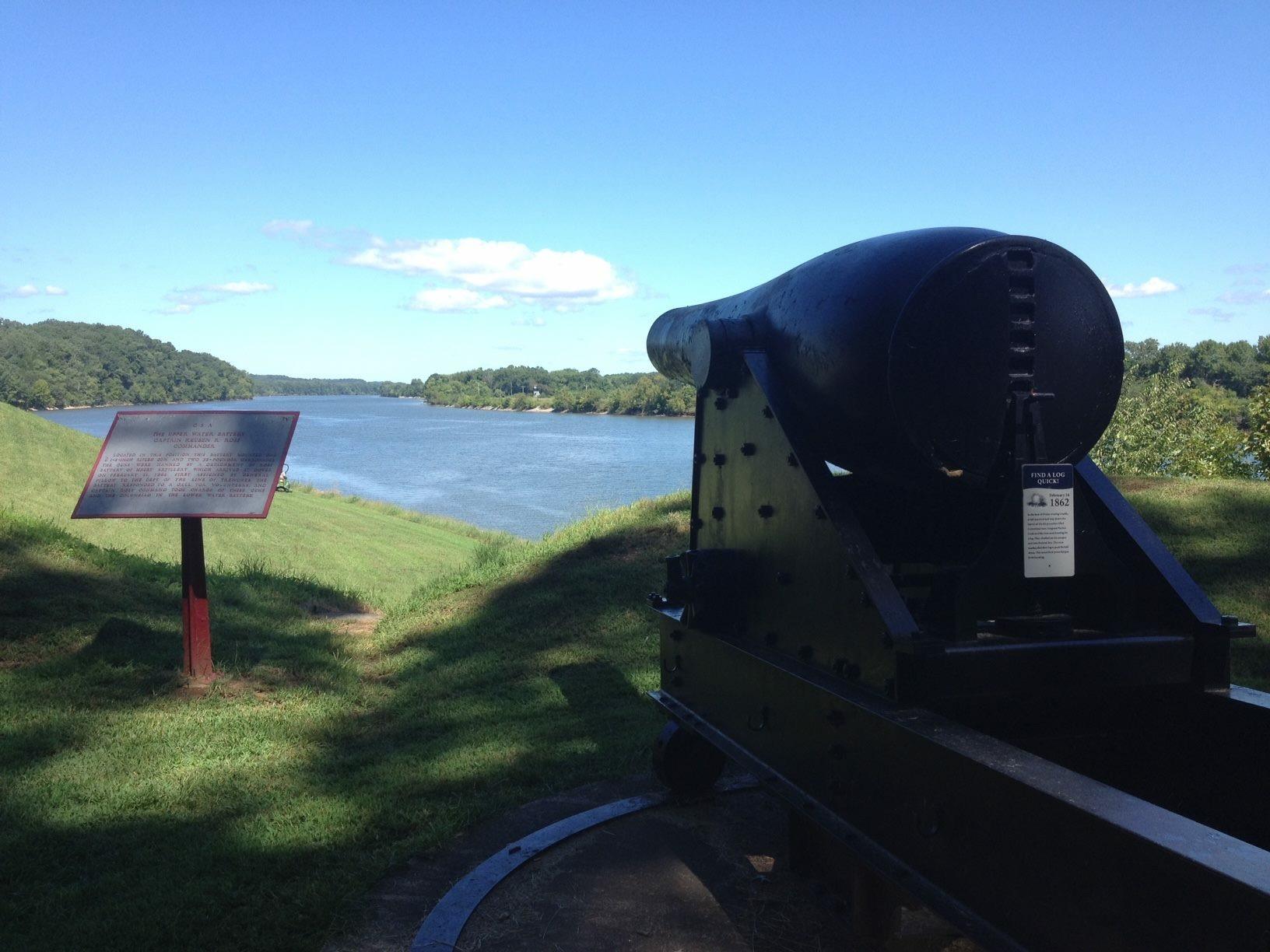
National Battlefield
Brigadier General Ulysses S. Grant was becoming quite famous as he wrote these words following the surrender of Confederate Fort Donelson on Sunday, February 16, 1862. The Union victory at Fort Donels...

National Battlefield
The Battle of Stones River began on the last day of 1862 and became one of the bloodiest conflicts of the Civil War. The battle produced important military and political gains for the Union, and it ch...
Park data from the National Park Service API. Alerts update every 2 hours.
Expect a decidedly turn-heavy local drive on this route, with no highway segments to speak of. You'll be traversing roads like Austin Peay Memorial Highway, Fort Donelson Parkway, and Lake Highway, which means you'll be actively steering for much of the journey. Given the 0% highway share and the nature of the route, there isn't a 'longest uninterrupted stretch' in the highway sense; instead, anticipate a continuous engagement with local roadways. This drive profile suggests a more intimate connection with the landscape as you move from point to point.
This is a straightforward highway drive that stays mostly on I 24 and Main Street. This route has several spots where lane changes, forks, or exits need your full attention. The trickiest moment comes around 72.8 miles in near I 24.
Demanding - plan breaks and stay ahead of the key maneuvers
Balances navigation complexity with total wheel time.
This is a demanding drive. With 17 significant decision points across 246.2 miles, you will need to stay alert - especially through interchange areas and urban stretches. Consider splitting it into segments if you are not comfortable with fast highway navigation.
Where does it get tricky?
The main spots that need attention: at 72.8 miles (I 24): Merge point - match speed before joining. Lane positioning matters here; at 106.1 miles (I 24): Highway fork - watch signs carefully. Lane positioning matters here. Multiple destination signs - pick the right one; at 111.2 miles (I 24): Highway fork - watch signs carefully. Lane positioning matters here. Multiple destination signs - pick the right one.
Gently rolling terrain
Total Climb
1,738 ft
Total Descent
1,570 ft
Highest Point
1,411 ft
~193.4 mi in
Elevation Range
1,028 ft
Based on OSRM destination-sign hints, not a full list of every settlement the road passes.
Between Paris, TN and East Chattanooga, TN, road signs point toward Knoxville and Chattanooga.
Knoxville
Chattanooga
Founded 1823
Paris is a city of 10,000 people (2019) in Western Tennessee. Visitors come to see the 70-foot (21 m) replica of the Eiffel Tower and for the "World's Biggest Fish Fry."
City content from Wikivoyage (CC BY-SA 4.0) and Wikidata (CC0).
Weekend Trip
Doable as a same-day drive at 4h 48m. Total distance: 246.2 miles.
Family Friendly
Moderate complexity with 1 natural rest stops along the way.
Solo Traveler
4h 48m drive, comfortable solo distance.
First-Time Driver
Mostly highway driving (70%). Some complex stretches to watch for.
Compiled by the US Trip Planner planning team at COD Solutions Oy from open government datasets — OSRM over OpenStreetMap for geometry, EIA for fuel prices, USGS 3DEP for elevation, NPS for national parks, and FHWA TMAS for hourly traffic volumes. See our methodology for refresh cadence and limitations.
Was this helpful?
Thanks for your feedback!
Your tip has been submitted. Thanks!
/500
Recent Tips
·
Explore more options from Paris, TN or browse trips ending in East Chattanooga, TN.
Looking for more statewide routes? Browse TN road trips.