Traveling from Morehead City to High Point covers 242.1 miles and takes approximately 4 hours and 5 minutes of total driving time. Because the route is categorized as a turn-heavy local drive, it is best suited as a single-day journey rather than a multi-day excursion. You should budget roughly $39 for fuel to complete the trip. Navigating through the Southeast, you will transition from the coastal environment of Morehead City toward the interior of North Carolina. Since the route relies on local roads like North 18th Street, Arendell Street, and West New Bern Road, your pace will be dictated by local traffic rather than highway speeds. This trip is manageable in one sitting, offering a direct path for those looking to connect these two distinct areas of the state.
Trip Pace
Same-day drive is realistic
A same-day return is possible, but it will make for a full day on the road.
Break Rhythm
1 planned break
Plan on a short reset every 3 to 4 hours to stay fresh behind the wheel.
Midpoint
120.8 miles from Morehead City, NC
A natural place for your longest stop of the day
, about 2h 29m into the drive
.
Main Roads
Road
Distance
Duration
I 40
89.8 mi
1h 44m
Arendell Street
69.2 mi
1h 26m
US 70
23.2 mi
29m
Goldsboro Bypass
20.2 mi
21m
US 29
12.5 mi
13m
US 70 BYP
10.1 mi
12m
Clayton Bypass Scenic Byway
10 mi
11m
West New Bern Road
3.3 mi
4m
Longest stretch:
I 40
— 89.8 mi, about 1h 44m
Traffic on I-40
Hour-of-day weekday pattern from 16 FHWA count stations on your route.
Peak
5 PM
~5,646 veh/hr typical
Quietest
2 AM
~369 veh/hr
Peak-to-quiet ratio
15.3×
busier at peak than in the quiet hours
12a6anoon6p11p
Averaged across 52 weeks of 2023 FHWA Travel Monitoring Analysis System data. Weekday hours only (Mon–Fri).
Turn-by-Turn Driving Directions
Step-by-step road directions between Morehead City, NC and High Point, NC.
1
Start on this road
247 ft·23 sec·this road
2
At end of road, turn left onto North 18th Street
123 ft·6 sec·North 18th Street
3
Turn right onto US 70
69 mi·1 hr 26 min·Arendell Street
Use the straight lane.
4
Continue on US 70; US 258
1.1 mi·1 min·West New Bern Road
Use the straight lane.
5
Keep slight right at fork onto US 70; US 258
2.1 mi·3 min·West New Bern Road
Use the straight lane.
6
Continue on US 70; US 258
1.6 mi·2 min·West Vernon Avenue
Use the straight / right lanes.
7
Continue on US 70
9.6 mi·11 min·US 70
Use the straight lane.
8
Continue on I 42
20 mi·21 min·Goldsboro Bypass
9
Continue on US 70
1.2 mi·1 min·US 70
Use the straight lane.
10
Continue on US 70
10 mi·14 min·US 70
Use the straight lane.
11
Continue on US 70
2.0 mi·2 min·US 70
Use the straight lane.
12
Keep slight left at fork onto US 70 BYP
10 mi·12 min·US 70 BYP
13
Continue on I 42
10.0 mi·11 min·Clayton Bypass Scenic Byway
14
Merge onto I 40
82 mi·1 hr 34 min·I 40
Use the straight / slight right lanes.
15
Keep slight right at fork onto I 40
7.7 mi·9 min·I 40
Use the straight / slight left lanes.
16
Keep slight left at fork onto US 29
5.4 mi·5 min·US 29
Toward I 85 Business South, US 29 South, US 70 West: CharlotteUse the left lane.
17
Keep slight right at fork onto US 29
7.1 mi·7 min·US 29
Toward US 29 SouthUse the slight right lane.
18
Take the exit
0.3 mi·35 sec
Toward South Main Street, DowntownUse the straight / slight right lanes.
19
Turn right onto South Main Street
1.6 mi·2 min·South Main Street
Use the straight lane.
20
Arrive at destination
South Main Street
Trip Plan
To make the most of your 4-hour and 5-minute trek, plan to depart early in the morning to avoid peak local traffic congestion. Since the route is entirely local, factor in at least one necessary stop to stretch your legs and refuel, keeping your $39 estimate in mind. Flexibility is your biggest advantage here, as you aren't tied to the rigid exit patterns of a major interstate. Given the turn-heavy nature of these roads, stay alert at intersections and follow your GPS closely to ensure you remain on the path through North 18th Street and Arendell Street. Prioritize consistent rest, as navigating local roads requires more mental focus than sustained highway driving.
Morning Departure
An early start around 7-8 AM gets you there with plenty of daylight left.
Evening Departure
A late afternoon start means arriving after dark. Morning is better.
You can normally do this drive in one day.
Plan roughly 1 meaningful break for fuel, food, and rest.
The halfway point lands around 120.8 miles from Morehead City, NC, or about 2h 29m into the drive.
The longest continuous stretch on this route runs about 89.8 miles.
This is a comfortable same-day trip.
Departure
Before you leave
Start with fuel, water, and navigation already sorted so the first hour feels easy.
First stop
Around 53 miles or 1h 6m in
Use this first pause for coffee, a restroom break, and a quick traffic check ahead.
Halfway reset
Around 120.8 miles or 2h 29m in
This is the best place for your longest stop, a real meal, and a full fuel check.
Final approach
Final hour starts around 3h 58m
Traffic, exits, and arrival timing usually matter more near High Point, NC than in the middle of the route.
Before You Leave
+
Open the route before leaving Morehead City, NC so your first major turns are already loaded.
+
Leave with enough water and a charging cable within reach, not packed away.
+
Check your fuel range against the first long segment, especially if you are starting outside city service areas.
Day 1
Settle into the route from Morehead City, NC
This is one driving day of about 241.7 miles and 4h 49m.
Your first comfortable stop window is around 53 miles from Morehead City, NC.
This route can stay practical as a one-day drive if traffic stays reasonable.
Plan about 1 real break rather than only quick fuel stops.
The longest stretch is on I 40 for about 89.8 miles.
Where to Stop
Rest stops, refuel points, and overnight suggestions along this route.
Place data sourced from public business listings. Hours and availability may vary.
Heads-up: tricky spots
5 of 10
5 decision points cluster between mile 0 and 239.8 — GPS handles the exact turns, but know they're coming. Your lane choice matters more than the turn itself.
6
0 mi into trip|~0m in|North 18th Street
At end of road, turn left onto North 18th Street
Complex interchange - multiple decisions in a short stretch
6
0.1 mi into trip|~0m in|US 70 / Arendell Street
Turn right onto US 70 / Arendell Street
Lane positioning matters here
Use the straight lane.
8
227.3 mi into trip|~4h 32m in|US 29
Keep slight left at fork onto US 29 toward I 85 Business South, US 29 South, US 70 West: Charlotte
Highway fork - watch signs carefully. Lane positioning matters here. Multiple destination signs - pick the right one
Use the left lane.
Toward I 85 Business South, US 29 South, US 70...
7
232.6 mi into trip|~4h 38m in|US 29
Keep slight right at fork onto US 29 toward US 29 South
Highway fork - watch signs carefully. Lane positioning matters here
Use the slight right lane.
Toward US 29 South
7
239.8 mi into trip|~4h 46m in
Take the exit toward South Main Street, Downtown
Exit ramp - move to the correct lane early. Lane positioning matters here. Multiple destination signs - pick the right one
Use the straight / slight right lanes.
Toward South Main Street, Downtown
Fuel & Cost
Regular Gas
$35.68 one way
$71.37 round trip
$3.75/gal25.4 MPG avg85 kg CO2
Fuel Type
$/gal
One Way
Round Trip
midgrade
$4.12
$39.21
$78.43
premium
$4.49
$42.74
$85.49
diesel
$4.80
$45.64
$91.28
No toll roads detected on this route.
Estimated Trip Cost (one way, 1 person)
Fuel
$36
Meals
$25–$50
Total
$61–$86
Rough estimate based on US averages. Hotel $80–$140/night, meals $25–$50/day.
Estimated CO2 emission: 84.6 kg one way.
Prices: EIA weekly data, 2026-07-13.
Driving Electric?
About $25 in charging
· 0 stops
· 67% less CO2
Vehicle Type
kWh
Stops
DC Fast
Home Charge
Average EV
72.5
0
$25.38
$11.60
Efficient EV
60.4
0
$21.15
$9.67
EV Truck/SUV
96.7
1
$33.84
$15.47
Gas CO2
85 kg
EV CO2
28 kg (67% less)
Plan for 0 charging stops, roughly every 270 miles. Allow 25-40 minutes per stop at a DC fast charger.
DC fast charging avg $0.35/kWh. Home charging avg $0.16/kWh. US grid CO2: 0.39 kg/kWh.
Travel Intel
Current conditions at both ends of the drive.
Forecast as of Jul 15, 2026
Origin
Morehead City, NC
Morning
in Morehead City on Sunday
Local time
6:28 AM
EDT
Current temp
72°F
Mostly Clear
NE 1 to 5 mph2% chanceLive forecast
Destination
High Point, NC
Morning
in High Point on Sunday
Local time
6:28 AM
EDT
Current temp
65°F
Clear
SW 1 mph0% chanceLive forecast
Seasonal Notes
Summer travel usually means heavier construction, hotter rest stops, and busier weekend traffic around major cities.
Winter travel shortens daylight, so a route that looks manageable on paper can feel much longer after dark.
Holiday weekends tend to make both departure and arrival windows slower than the raw route time suggests.
Time zone
Same local time
Origin and destination are on the same clock, so arrival timing is easier to judge at a glance.
Temperature spread
7 degrees cooler at arrival
A meaningful temperature swing is a good cue to rethink layers, water, and how soon you want to arrive.
Road read
4h 49m on the road
An early start around 7-8 AM gets you there with plenty of daylight left.
Weather data from the National Weather Service. Conditions may change; check closer to your travel date.
National Parks Near This Route
Worth a detour if your schedule allows.
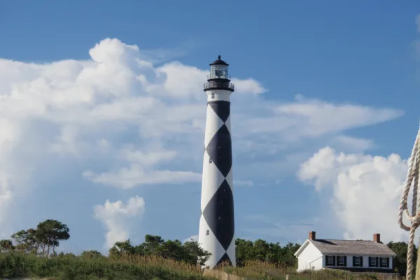
Cape Lookout National Seashore
National Seashore
A boat ride three miles off-shore brings you to the barrier islands of Cape Lookout National Seashore. Horse watching, shelling, fishing, birding, camping, lighthouse climbing, and touring historic vi...
Park data from the National Park Service API. Alerts update every 2 hours.
More Details
What kind of drive is this?
Expect a hands-on driving experience as this route features zero percent highway share, meaning you will spend your entire trip on local roads. The path is defined by a turn-heavy profile that requires your full attention, moving away from the straight-line ease of major interstates. You will navigate through various intersections and transitions using North 18th Street, Arendell Street, and West New Bern Road. Unlike a monotonous highway grind, this drive demands active steering and frequent adjustments as you progress through the local landscape. Prepare for a steady, grounded pace that keeps you engaged with the road conditions from start to finish.
56% highway, the rest on surface roads — varied driving throughout.
20 navigation steps total — most of the decisions cluster near the start and finish.
Longest single stretch: 89.8 mi on I 40.
How Hard Is This Drive?
7/10
This route mixes highway mileage with some local-road sections near the start or finish. This route has several spots where lane changes, forks, or exits need your full attention. The trickiest moment comes early in the drive near North 18th Street.
Driving Effort7/10
Demanding - plan breaks and stay ahead of the key maneuvers
Balances navigation complexity with total wheel time.
This is a demanding drive. With 10 significant decision points across 241.7 miles, you will need to stay alert - especially through interchange areas and urban stretches. Consider splitting it into segments if you are not comfortable with fast highway navigation.
Where does it get tricky?
The main spots that need attention: near the start (North 18th Street): Complex interchange - multiple decisions in a short stretch; at 0.1 miles (US 70 / Arendell Street): Lane positioning matters here; at 227.3 miles (US 29): Highway fork - watch signs carefully. Lane positioning matters here. Multiple destination signs - pick the right one.
Morehead City is the largest town in the Crystal Coast region of North Carolina, with a population of 7,691 (as of 2000). Morehead (as it is usually called) is not actually in the Outer Banks, being situated on the opposite shore of the Bogue Sound from Atlantic Beach, and is the main gateway to the island of Bogue Banks.
High Point is part of the Piedmont Triad in North Carolina, along with Greensboro and Winston-Salem. High Point is often referred to as the furniture capital of the world due not only to the large number of furniture manufactures in the area, but also because of the International Home Furnishings Markets held each spring and fall. Over 8 million square feet of showroom space is used to draw over 70,000 people from all over the world to each market. This nearly doubles the population of High Point resulting in an economic boom to the entire Triad Area as hotel and motel rooms sell out and many residents rent out rooms, floors, or even their entire home for all or part of the 7 to 10 days during the market period.
Top landmarks
•Highland Cotton Mills Village Historic District — historic district in High Point, North Carolina
•Pickett Cotton Mills — historic industrial property at 1200 Redding Drive in southwestern High Point, N...
Doable as a same-day drive at 4h 49m. Total distance: 241.7 miles.
Family Friendly
Moderate complexity with 1 natural rest stops along the way.
Solo Traveler
4h 49m drive, comfortable solo distance.
Scenic Drive
Mixed highway & surface route profile with national parks nearby.
Frequently Asked Questions
The longest stretch is about 89.8 miles on I 40. The full list of main roads is in the Roads section above.
Yes — we found about 14 rest areas or service plazas within a short detour of the route (from OpenStreetMap). See the Rest Stops tab under Nearby Places for locations and mile markers. Plan to stretch, use the bathroom, and top off fluids every 2–3 hours on longer drives.
It helps. This route has a higher-than-average number of complex decision points, which get harder in the dark. If the last hour of the trip is on surface roads or mountain grades, aim to arrive at High Point, NC before sunset when you can. Check the Trip Plan for departure windows that land you in daylight.
Only with planning. This is a long drive for kids — consider splitting it into two days rather than pushing through. Plan at least 1 meaningful breaks. There are 14 rest areas along the route for bathroom stops.
The main spots that need attention: near the start (North 18th Street): Complex interchange - multiple decisions in a short stretch; at 0.1 miles (US 70 / Arendell Street): Lane positioning matters here; at 227.3 miles (US 29): Highway fork - watch signs carefully. Lane positioning matters here. Multiple destination signs - pick the right one.
Yes — Cape Lookout National Seashore. See the National Parks section for detour distances and tips on detours.
Possible but tiring. At 4.8 hours each way, an in-and-out day trip would put you behind the wheel for 9.7 hours — manageable with a long break at High Point, NC, but most travelers stay overnight.