Traveling from High Point to Wanchese covers 282.9 miles across the heart of North Carolina, typically taking about 5 hours and 38 minutes of drive time. Because this journey stays within the Southeast, you will notice a consistent regional feel as you transition from the Piedmont toward the coast. With a fuel budget of approximately $45, the route is efficient enough to manage in a single day, though it is a substantial haul. You should view this as a straightforward, highway-focused trek rather than a leisurely sightseeing tour. If you prefer a relaxed pace, you might consider an overnight stay, but the drive is manageable for a focused traveler who wants to reach the coast in one go.
Trip Pace
Same-day drive is realistic
A same-day return is possible, but it will make for a full day on the road.
Break Rhythm
1 planned break
Plan on a short reset every 3 to 4 hours to stay fresh behind the wheel.
Midpoint
141.5 miles from High Point, NC
A natural place for your longest stop of the day
, about 2h 42m into the drive
.
Main Roads
Road
Distance
Duration
US 64
102.3 mi
1h 56m
I 40
67.1 mi
1h 17m
United States Highway 64 East
40.5 mi
49m
US 64 ALT
20.2 mi
28m
I 87
16.8 mi
17m
US 29
14.4 mi
16m
I 440
9.2 mi
11m
NC 345
3.6 mi
6m
Longest stretch:
US 64
— 102.3 mi, about 1h 56m
Turn-by-Turn Driving Directions
Step-by-step road directions between High Point, NC and Wanchese, NC.
1
Start on South Main Street
1.8 mi·3 min·South Main Street
Use the straight / right lanes.
2
Take the ramp
0.3 mi·35 sec
3
Merge onto US 29
8.5 mi·9 min·US 29
Use the straight / slight right lanes.
4
Keep slight right at fork onto US 29
5.9 mi·6 min·US 29
Toward US 29, US 70Use the straight / slight right lanes.
5
Keep slight left at fork onto I 40
37 mi·42 min·I 40
Use the straight / slight right lanes.
6
Keep slight right at fork onto I 40
30 mi·34 min·I 40
Toward I 40 East: RaleighUse the straight / slight right lanes.
7
Keep slight right at fork onto SR 1728
3.1 mi·3 min·Wade Avenue
Exit 289Toward Wade AvenueUse the slight right lane.
8
Take the exit
0.5 mi·1 min
Toward I 440 East, US 1 North: Wake Forest
9
Merge onto I 440; US 1
9.2 mi·11 min·I 440; US 1
Use the straight lane.
10
Take the exit
0.7 mi·57 sec
Toward I 87 North, US 64 East, US 264 East: Rocky Mount, Wilson, GreenvilleUse the slight right lane.
11
Merge onto I 87; US 64; US 264
17 mi·17 min·I 87; US 64; US 264
12
Keep slight left at fork onto US 64
80 mi·1 hr 26 min·US 64
13
Turn right onto US 64 ALT
20 mi·28 min·US 64 ALT
Use the straight lane.
14
Continue on US 64; NC 32
1.0 mi·1 min·United States Highway 64 East
15
Continue on US 64; NC 32
2.3 mi·3 min·U.S. Highway 64 East
16
Continue on US 64
40 mi·47 min·United States Highway 64 East
Use the straight lane.
17
Keep slight right at fork onto US 64
23 mi·30 min·US 64
18
Turn right onto NC 345
3.6 mi·6 min·NC 345
19
Turn right onto Old Schoolhouse Road
0.2 mi·49 sec·Old Schoolhouse Road
20
Arrive at destination
Old Schoolhouse Road
Trip Plan
To make the most of this 282.9-mile transit, aim for an early departure to avoid potential traffic bottlenecks during the commute hours. With only one recommended stop planned, you should prioritize choosing a location along the 102.3-mile stretch of US 64 to stretch your legs and refuel effectively. Keep your $45 fuel budget in mind, as prices can fluctuate depending on where you choose to fill up along the interstate segments. Because this is a long, highway-heavy route, ensure your vehicle is prepped for sustained speeds before you leave High Point. Flexibility is your biggest advantage here, so monitor your energy levels and don't hesitate to add a second quick break if you feel fatigued.
Morning Departure
An early start around 7-8 AM gets you there with plenty of daylight left.
Evening Departure
A late afternoon start means arriving after dark. Morning is better.
You can normally do this drive in one day.
Plan roughly 1 meaningful break for fuel, food, and rest.
The halfway point lands around 141.5 miles from High Point, NC, or about 2h 42m into the drive.
The longest continuous stretch on this route runs about 102.3 miles.
This is a comfortable same-day trip.
Departure
Before you leave
Start with fuel, water, and navigation already sorted so the first hour feels easy.
First stop
Around 62 miles or 1h 12m in
Use this first pause for coffee, a restroom break, and a quick traffic check ahead.
Halfway reset
Around 141.5 miles or 2h 42m in
This is the best place for your longest stop, a real meal, and a full fuel check.
Final approach
Final hour starts around 4h 31m
Traffic, exits, and arrival timing usually matter more near Wanchese, NC than in the middle of the route.
Before You Leave
+
Open the route before leaving High Point, NC so your first major turns are already loaded.
+
Leave with enough water and a charging cable within reach, not packed away.
+
Check your fuel range against the first long segment, especially if you are starting outside city service areas.
Day 1
Settle into the route from High Point, NC
This is one driving day of about 282.9 miles and 5h 38m.
Your first comfortable stop window is around 62 miles from High Point, NC.
This route can stay practical as a one-day drive if traffic stays reasonable.
Plan about 1 real break rather than only quick fuel stops.
The longest stretch is on US 64 for about 102.3 miles.
Where to Stop
Rest stops, refuel points, and overnight suggestions along this route.
Place data sourced from public business listings. Hours and availability may vary.
Heads-up: tricky spots
5 of 16
5 decision points cluster between mile 10.5 and 96.3 — GPS handles the exact turns, but know they're coming. Your lane choice matters more than the turn itself.
8
10.5 mi into trip|~13m in|US 29
Keep slight right at fork onto US 29 toward US 29, US 70
Highway fork - watch signs carefully. Lane positioning matters here. Multiple destination signs - pick the right one
Use the straight / slight right lanes.
Toward US 29, US 70
6
16.5 mi into trip|~20m in|I 40
Keep slight left at fork onto I 40
Highway fork - watch signs carefully. Lane positioning matters here
Use the straight / slight right lanes.
7
53.2 mi into trip|~1h 2m in|I 40
Keep slight right at fork onto I 40 toward I 40 East: Raleigh
Highway fork - watch signs carefully. Lane positioning matters here
Use the straight / slight right lanes.
Toward I 40 East: Raleigh
8
83.5 mi into trip|~1h 37m in|SR 1728 / Wade Avenue
Keep slight right at fork onto SR 1728 / Wade Avenue toward Wade Avenue
Highway fork - watch signs carefully. Lane positioning matters here
Use the slight right lane.
Exit 289
Toward Wade Avenue
7
96.3 mi into trip|~1h 54m in
Take the exit toward I 87 North, US 64 East, US 264 East: Rocky Mount, Wilson, Greenville
Exit ramp - move to the correct lane early. Lane positioning matters here. Multiple destination signs - pick the right one
Use the slight right lane.
Toward I 87 North, US 64 East, US 264 East: Roc...
Fuel & Cost
Regular Gas
$41.77 one way
$83.53 round trip
$3.75/gal25.4 MPG avg99 kg CO2
Fuel Type
$/gal
One Way
Round Trip
midgrade
$4.12
$45.90
$91.80
premium
$4.49
$50.03
$100.06
diesel
$4.80
$53.42
$106.83
No toll roads detected on this route.
Estimated Trip Cost (one way, 1 person)
Fuel
$42
Meals
$25–$50
Total
$67–$92
Rough estimate based on US averages. Hotel $80–$140/night, meals $25–$50/day.
Estimated CO2 emission: 99 kg one way.
Prices: EIA weekly data, 2026-07-13.
Driving Electric?
About $30 in charging
· 1 stop
· 67% less CO2
Vehicle Type
kWh
Stops
DC Fast
Home Charge
Average EV
84.9
1
$29.70
$13.58
Efficient EV
70.7
0
$24.75
$11.32
EV Truck/SUV
113.2
1
$39.61
$18.11
Gas CO2
99 kg
EV CO2
33 kg (67% less)
Plan for 1 charging stop. A 30-minute DC fast charge mid-route should be enough to complete the trip comfortably.
DC fast charging avg $0.35/kWh. Home charging avg $0.16/kWh. US grid CO2: 0.39 kg/kWh.
Travel Intel
Current conditions at both ends of the drive.
Forecast as of Jul 18, 2026
Origin
High Point, NC
Morning
in High Point on Sunday
Local time
10:45 AM
EDT
Current temp
74°F
Isolated Showers And Thunderstorms then Partly Cloudy
S 5 mph16% chanceLive forecast
Beach Hazards Statement
Beach Hazards Statement issued July 17 at 9:15PM EDT until July 18 at 8:00PM EDT by NWS Wilmington NC
Destination
Wanchese, NC
Morning
in Wanchese on Sunday
Local time
10:45 AM
EDT
Current temp
80°F
Mostly Cloudy
S 9 mph1% chanceLive forecast
Beach Hazards Statement
Beach Hazards Statement issued July 17 at 9:15PM EDT until July 18 at 8:00PM EDT by NWS Wilmington NC
Seasonal Notes
Summer travel usually means heavier construction, hotter rest stops, and busier weekend traffic around major cities.
Winter travel shortens daylight, so a route that looks manageable on paper can feel much longer after dark.
Holiday weekends tend to make both departure and arrival windows slower than the raw route time suggests.
Time zone
Same local time
Origin and destination are on the same clock, so arrival timing is easier to judge at a glance.
Temperature spread
6 degrees warmer at arrival
A meaningful temperature swing is a good cue to rethink layers, water, and how soon you want to arrive.
Road read
5h 38m on the road
An early start around 7-8 AM gets you there with plenty of daylight left.
Weather data from the National Weather Service. Conditions may change; check closer to your travel date.
National Parks Near This Route
Worth a detour if your schedule allows.
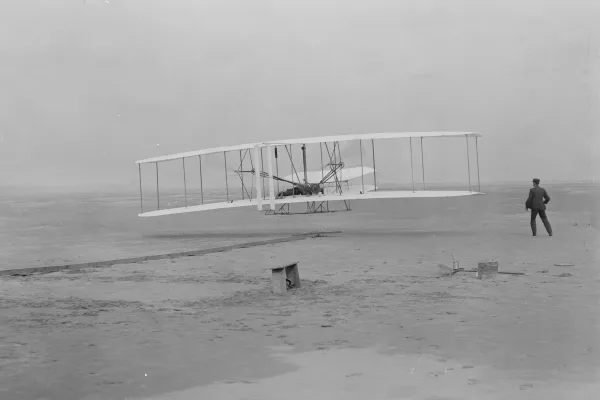
Wright Brothers National Memorial
National Memorial
Wind, sand, and a dream of flight brought Wilbur and Orville Wright to Kitty Hawk, North Carolina where, after four years of scientific experimentation, they achieved the first successful airplane fli...
10 mi from route
~26 min detour
$10
near mile 273.2
The sound of ocean waves, the starry night sky, or the calm of the salt marshes, you can experience it all. Shaped by the forces of water, wind, and storms these islands are ever changing. The plants,...
30 mi from route
~74 min detour
Free
near mile 282.9
Park data from the National Park Service API. Alerts update every 2 hours.
More Details
What kind of drive is this?
This trip is defined by its reliance on major transit arteries, with 98% of the journey spent on highways like I-40 and US 64. You will experience a very consistent road personality, dominated by high-speed travel that prioritizes efficiency over local winding roads. The longest uninterrupted stretch lasts for 102.3 miles on US 64, requiring you to stay alert during extended periods of highway driving. As you move away from the High Point area, the transition onto US 64 East serves as the backbone of the trip, carrying you steadily toward your destination. Expect a predictable experience behind the wheel that favors steady cruising over frequent navigational changes.
98% highway — fuel and pacing are the main things to plan.
20 navigation steps total — most of the decisions cluster near the start and finish.
Longest single stretch: 102.3 mi on US 64.
How Hard Is This Drive?
8/10
This is a straightforward highway drive that stays mostly on US 64 and I 40. This route has several spots where lane changes, forks, or exits need your full attention. The trickiest moment comes around 10.5 miles in near US 29.
Driving Effort8/10
Demanding - plan breaks and stay ahead of the key maneuvers
Balances navigation complexity with total wheel time.
This is a demanding drive. With 16 significant decision points across 282.9 miles, you will need to stay alert - especially through interchange areas and urban stretches. Consider splitting it into segments if you are not comfortable with fast highway navigation.
Where does it get tricky?
The main spots that need attention: at 10.5 miles (US 29): Highway fork - watch signs carefully. Lane positioning matters here. Multiple destination signs - pick the right one; at 16.5 miles (I 40): Highway fork - watch signs carefully. Lane positioning matters here; at 53.2 miles (I 40): Highway fork - watch signs carefully. Lane positioning matters here.
Elevation Profile
Mostly flat terrain
922 ft1 ft
Total Climb
36 ft
Total Descent
951 ft
Highest Point
922 ft
Elevation Range
922 ft
Towns Mentioned on Route Signs
Based on OSRM destination-sign hints, not a full list of every settlement the road passes.
Between High Point, NC and Wanchese, NC, road signs point toward Wilson and Greenville.
High Point is part of the Piedmont Triad in North Carolina, along with Greensboro and Winston-Salem. High Point is often referred to as the furniture capital of the world due not only to the large number of furniture manufactures in the area, but also because of the International Home Furnishings Markets held each spring and fall. Over 8 million square feet of showroom space is used to draw over 70,000 people from all over the world to each market. This nearly doubles the population of High Point resulting in an economic boom to the entire Triad Area as hotel and motel rooms sell out and many residents rent out rooms, floors, or even their entire home for all or part of the 7 to 10 days during the market period.
Top landmarks
•Highland Cotton Mills Village Historic District — historic district in High Point, North Carolina
•Pickett Cotton Mills — historic industrial property at 1200 Redding Drive in southwestern High Point, N...
Doable as a same-day drive at 5h 38m. Total distance: 282.9 miles.
Family Friendly
Moderate complexity with 1 natural rest stops along the way.
Solo Traveler
5h 38m drive, comfortable solo distance.
First-Time Driver
Mostly highway driving (98%). Some complex stretches to watch for.
Frequently Asked Questions
The longest stretch is about 102.3 miles on US 64. The full list of main roads is in the Roads section above.
Yes — we found about 13 rest areas or service plazas within a short detour of the route (from OpenStreetMap). See the Rest Stops tab under Nearby Places for locations and mile markers. Plan to stretch, use the bathroom, and top off fluids every 2–3 hours on longer drives.
It helps. This route has a higher-than-average number of complex decision points, which get harder in the dark. If the last hour of the trip is on surface roads or mountain grades, aim to arrive at Wanchese, NC before sunset when you can. Check the Trip Plan for departure windows that land you in daylight.
Only with planning. This is a long drive for kids — consider splitting it into two days rather than pushing through. Plan at least 1 meaningful breaks. There are 13 rest areas along the route for bathroom stops.
The main spots that need attention: at 10.5 miles (US 29): Highway fork - watch signs carefully. Lane positioning matters here. Multiple destination signs - pick the right one; at 16.5 miles (I 40): Highway fork - watch signs carefully. Lane positioning matters here; at 53.2 miles (I 40): Highway fork - watch signs carefully. Lane positioning matters here.
Yes — Wright Brothers National Memorial and Cape Hatteras National Seashore. See the National Parks section for detour distances and tips on detours.
Not recommended in a single day. At 5.6 hours each way, a round trip means 11.3 hours of driving — that is an unsafe level of fatigue for most drivers. Plan at least one night at Wanchese, NC before the return drive.