Traveling from Mammoth Lakes to Los Angeles covers 308.6 miles and typically takes about 6 hours and 7 minutes of drive time. Because this journey stays within the Pacific Coast region of California, you will remain in the same geographic context while transitioning from the high elevation of the Sierras to the sprawling urban landscape of LA. Budgeting approximately $42 for fuel is a smart move before you head out. While it is technically possible to complete this drive in a single day, the duration makes it a full-day commitment. This route works best as a direct transit, providing a straightforward way to reach the city without needing an overnight stop unless you prefer a slower pace.
Trip Pace
Same-day drive is realistic
A same-day return is possible, but it will make for a full day on the road.
Break Rhythm
1 planned break
Plan on a short reset every 3 to 4 hours to stay fresh behind the wheel.
Midpoint
154.3 miles from Mammoth Lakes, CA
A natural place for your longest stop of the day
, about 3h 9m into the drive
.
Main Roads
Road
Distance
Duration
Grand Army of the Republic Highway
104.6 mi
2h 2m
Antelope Valley Freeway
49.1 mi
54m
Aerospace Highway
42.1 mi
47m
Dave McCoy Memorial Highway
36.4 mi
42m
Midland Trail
22 mi
25m
Hollywood Freeway
16.2 mi
20m
Blue Star Memorial Highway
7 mi
8m
I 5 Truck
5.6 mi
6m
Longest stretch:
Grand Army of the Republic Highway
— 104.6 mi, about 2h 2m
Turn-by-Turn Driving Directions
Step-by-step road directions between Mammoth Lakes, CA and Los Angeles, CA.
1
Start on this road
296 ft·27 sec·this road
2
Turn left
229 ft·21 sec
3
Turn left onto CA 203
3.2 mi·5 min·Main Street
4
Take the ramp
0.2 mi·17 sec
5
Merge onto US 395
36 mi·42 min·Dave McCoy Memorial Highway
Use the straight lane.
6
Turn right onto North Barlow Lane
1.0 mi·1 min·North Barlow Lane
7
Turn left onto CA 168
1.5 mi·2 min·West Line Street
8
Turn right onto US 395; CA 168; US 6 Hist
2.4 mi·3 min·South Main Street
9
Continue on US 395; CA 168; US 6 Hist
5.0 mi·5 min·El Camino Sierra
Use the straight / slight right lanes.
10
Continue on US 395; CA 168; US 6 Hist
7.4 mi·8 min·Grand Army of the Republic Highway
Use the straight lane.
11
Continue on US 395; US 6 Hist
0.2 mi·32 sec·North Main Street
12
Continue on US 395; US 6 Hist
26 mi·31 min·Grand Army of the Republic Highway
Use the straight lane.
13
Continue on US 395; US 6 Hist
0.7 mi·1 min·North Edwards Street
14
Continue on US 395; US 6 Hist
15 mi·17 min·Grand Army of the Republic Highway
Use the straight lane.
15
Continue on US 395; US 6 Hist
2.2 mi·4 min·North Main Street
16
Continue on US 395; US 6 Hist
56 mi·1 hr 4 min·Grand Army of the Republic Highway
Use the straight lane.
17
Continue on US 395; US 6 Hist
7.0 mi·8 min·Blue Star Memorial Highway
Use the straight lane.
18
Keep slight right at fork onto CA 14; US 6 Hist
6.4 mi·7 min·Aerospace Highway
Use the slight left / slight right lanes.
19
Continue on CA 14; CA 178; US 6 Hist
22 mi·25 min·Midland Trail
20
Continue on CA 14; US 6 Hist
20 mi·23 min·Aerospace Highway
Use the straight / slight right lanes.
21
At end of road, turn left onto CA 14; CA 58 BUS; US 6 Hist
4.7 mi·6 min·Sierra Highway
Use the left lane.
22
Continue on CA 14
16 mi·16 min·Aerospace Highway
Use the straight / slight right lanes.
23
Continue on CA 14; CA 138
48 mi·53 min·Antelope Valley Freeway
Use the straight / slight right lanes.
24
Keep slight left at fork onto CA 14
1.0 mi·1 min·Antelope Valley Freeway
Use the straight / slight right lanes.
25
Keep slight left at fork
0.5 mi·36 sec
Use the straight / slight right lanes.
26
Merge onto I 5
2.6 mi·3 min·Golden State Freeway
Use the straight / slight right lanes.
27
Keep slight right at fork onto I 5 Truck
0.3 mi·17 sec·I 5 Truck
Exit 158Toward I 405 SouthUse the straight / slight right lanes.
28
Keep slight left at fork onto I 5 Truck
5.3 mi·6 min·I 5 Truck
Use the straight / slight right lanes.
29
Take the exit
0.5 mi·32 sec
Exit 153BToward CA 170 South: HollywoodUse the straight / slight right lanes.
30
Continue on CA 170
16 mi·20 min·Hollywood Freeway
Use the straight / slight right lanes.
31
Take the exit
0.1 mi·17 sec
Exit 2CToward BroadwayUse the straight / slight right lanes.
32
Continue on West Aliso Street
409 ft·18 sec·West Aliso Street
Use the straight lane.
33
Turn right onto North Spring Street
0.3 mi·35 sec·North Spring Street
Use the right lane.
34
Turn left onto West 1st Street
354 ft·12 sec·West 1st Street
Use the left lane.
35
Arrive at destination
West 1st Street
Trip Plan
To make the most of this 6-hour-plus trek, plan your departure early to account for the single stop recommended for your itinerary. Since the route features a significant 104.6-mile stretch without major intersections, ensure your vehicle is fueled up and your supplies are packed before leaving Mammoth Lakes. The $42 fuel estimate is a helpful baseline, but keep in mind that mountain driving can impact your actual consumption. Flexibility is your biggest advantage on this route; since it is a single-day trip, feel free to adjust your pace based on traffic flow as you approach the Los Angeles basin. Keep a close watch on your navigation as you transition between the primary highways to ensure you maintain a smooth, steady rhythm.
Morning Departure
Start early — leave by 6-7 AM to arrive at a reasonable hour.
Evening Departure
This is a long drive — plan for a morning departure or consider splitting it into two days.
You can normally do this drive in one day.
Plan roughly 1 meaningful break for fuel, food, and rest.
The halfway point lands around 154.3 miles from Mammoth Lakes, CA, or about 3h 9m into the drive.
The longest continuous stretch on this route runs about 104.6 miles.
This is a comfortable same-day trip.
Departure
Before you leave
Start with fuel, water, and navigation already sorted so the first hour feels easy.
First stop
Around 68 miles or 1h 25m in
Use this first pause for coffee, a restroom break, and a quick traffic check ahead.
Halfway reset
Around 154.3 miles or 3h 9m in
This is the best place for your longest stop, a real meal, and a full fuel check.
Final approach
Final hour starts around 5h 1m
Traffic, exits, and arrival timing usually matter more near Los Angeles, CA than in the middle of the route.
Before You Leave
+
Open the route before leaving Mammoth Lakes, CA so your first major turns are already loaded.
+
Leave with enough water and a charging cable within reach, not packed away.
+
Check your fuel range against the first long segment, especially if you are starting outside city service areas.
Day 1
Settle into the route from Mammoth Lakes, CA
This is one driving day of about 308.6 miles and 6h 7m.
Your first comfortable stop window is around 68 miles from Mammoth Lakes, CA.
This route can stay practical as a one-day drive if traffic stays reasonable.
Plan about 1 real break rather than only quick fuel stops.
The longest stretch is on Grand Army of the Republic Highway for about 104.6 miles.
Where to Stop
Rest stops, refuel points, and overnight suggestions along this route.
Place data sourced from public business listings. Hours and availability may vary.
Heads-up: tricky spots
5 of 18
5 decision points cluster between mile 285.8 and 308.5 — GPS handles the exact turns, but know they're coming. Your lane choice matters more than the turn itself.
8
285.8 mi into trip|~5h 38m in|I 5 Truck
Keep slight right at fork onto I 5 Truck toward I 405 South
Highway fork - watch signs carefully. Lane positioning matters here
Use the straight / slight right lanes.
Exit 158
Toward I 405 South
7
291.4 mi into trip|~5h 44m in
Take the exit toward CA 170 South: Hollywood
Exit ramp - move to the correct lane early. Lane positioning matters here
Use the straight / slight right lanes.
Exit 153B
Toward CA 170 South: Hollywood
7
308 mi into trip|~6h 6m in
Take the exit toward Broadway
Exit ramp - move to the correct lane early. Lane positioning matters here
Use the straight / slight right lanes.
Exit 2C
Toward Broadway
7
308.2 mi into trip|~6h 6m in|North Spring Street
Turn right onto North Spring Street
Lane positioning matters here
Use the right lane.
7
308.5 mi into trip|~6h 7m in|West 1st Street
Turn left onto West 1st Street
Lane positioning matters here
Use the left lane.
Fuel & Cost
Regular Gas
$70.93 one way
$141.86 round trip
$5.84/gal25.4 MPG avg108 kg CO2
Fuel Type
$/gal
One Way
Round Trip
midgrade
$6.02
$73.09
$146.18
premium
$6.18
$75.05
$150.10
diesel
$5.61
$68.13
$136.27
No toll roads detected on this route.
Estimated Trip Cost (one way, 1 person)
Fuel
$71
Meals
$25–$50
Total
$96–$121
Rough estimate based on US averages. Hotel $80–$140/night, meals $25–$50/day.
Estimated CO2 emission: 108 kg one way.
Prices: EIA weekly data, 2026-04-13.
Driving Electric?
About $32 in charging
· 1 stop
· 67% less CO2
Vehicle Type
kWh
Stops
DC Fast
Home Charge
Average EV
92.6
1
$32.40
$14.81
Efficient EV
77.2
0
$27.00
$12.34
EV Truck/SUV
123.4
1
$43.20
$19.75
Gas CO2
108 kg
EV CO2
36 kg (67% less)
Plan for 1 charging stop. A 30-minute DC fast charge mid-route should be enough to complete the trip comfortably.
DC fast charging avg $0.35/kWh. Home charging avg $0.16/kWh. US grid CO2: 0.39 kg/kWh.
Travel Intel
Current conditions at both ends of the drive.
Forecast as of Apr 18, 2026
Origin
Mammoth Lakes, CA
Night
in Mammoth Lakes on Saturday
Local time
9:25 PM
PDT
Current temp
43°F
Unavailable
Live forecast
Destination
Los Angeles, CA
Night
in Los Angeles on Saturday
Local time
9:25 PM
PDT
Current temp
53°F
Mostly Clear
N 5 to 10 mph0% chanceLive forecast
53°F
Indian Wells, CA
154 mi in
Seasonal Notes
Summer travel usually means heavier construction, hotter rest stops, and busier weekend traffic around major cities.
Winter travel shortens daylight, so a route that looks manageable on paper can feel much longer after dark.
Holiday weekends tend to make both departure and arrival windows slower than the raw route time suggests.
Time zone
Same local time
Origin and destination are on the same clock, so arrival timing is easier to judge at a glance.
Temperature spread
10 degrees warmer at arrival
A meaningful temperature swing is a good cue to rethink layers, water, and how soon you want to arrive.
Road read
6h 7m on the road
Start early — leave by 6-7 AM to arrive at a reasonable hour.
Weather data from the National Weather Service. Conditions may change; check closer to your travel date.
National Parks Near This Route
Worth a detour if your schedule allows.
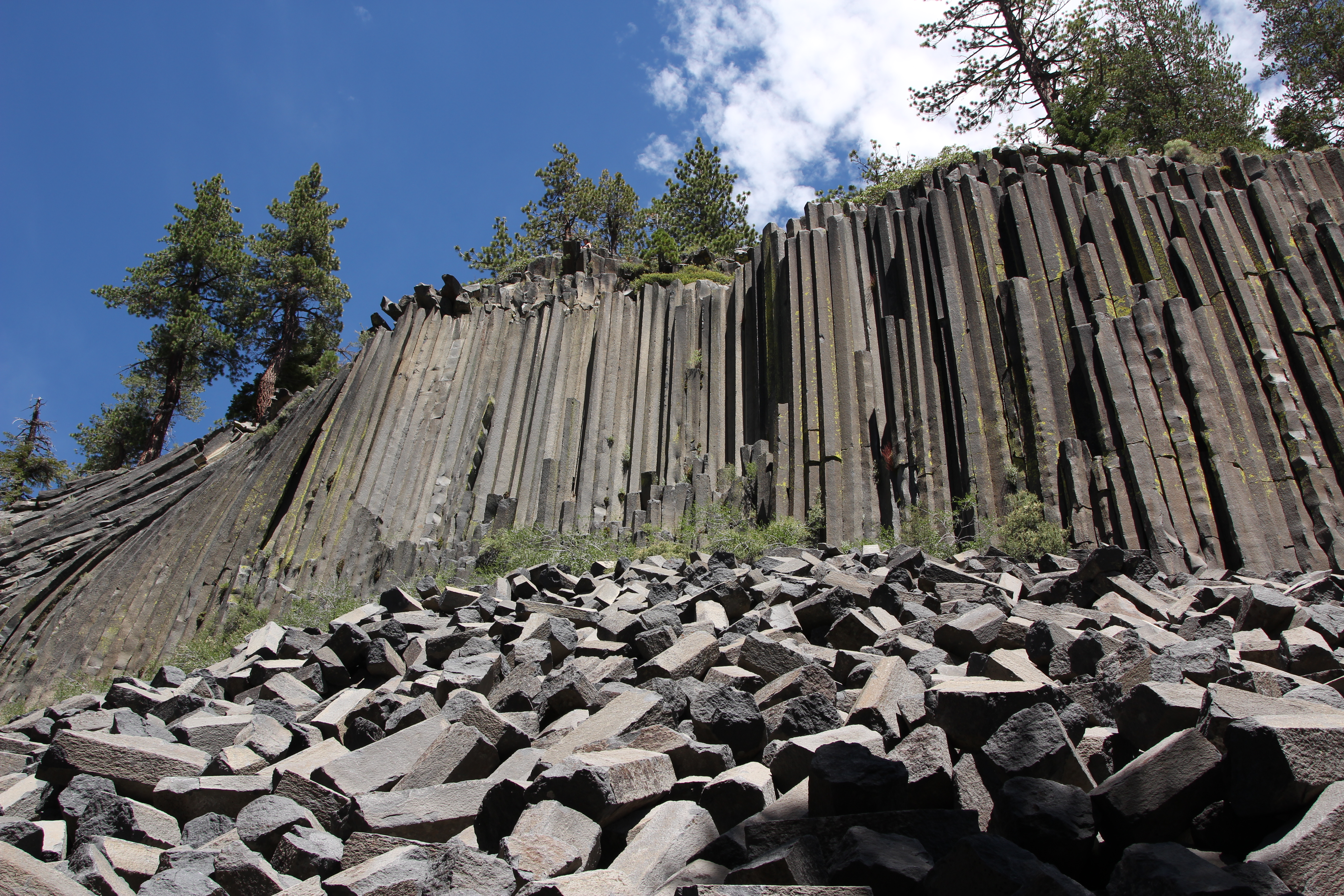
Devils Postpile National Monument
National Monument
Established in 1911 by presidential proclamation, Devils Postpile National Monument protects and preserves the Devils Postpile formation, the 101-foot high Rainbow Falls, and pristine mountain scenery...
7 mi from route
~17 min detour
Free
Park Closure: Reds Meadow Road Access Restrictions in 2026
Park Closure: Devils Postpile National Monument facilities are closed for the season
The Santa Monica Mountains offer easy access to surprisingly wild places. Experience the famous beaches of Malibu or explore more than 500 miles of trails. The park abounds with historical and cultura...
22 mi from route
~55 min detour
Free
near mile 287.3
Yes, we can! Widely recognized as the most important Latino leader in the United States during the twentieth century, Cesar Chavez led farm workers and supporters in the establishment of the country's...
24 mi from route
~61 min detour
Free
near mile 212.8
Park data from the National Park Service API. Alerts update every 2 hours.
More Details
What kind of drive is this?
Expect a varied experience behind the wheel, as this is a turn-heavy local drive rather than a simple interstate cruise. You will spend roughly 24% of your time on highways, navigating a mix of roads including the Grand Army of the Republic Highway, the Antelope Valley Freeway, and the Aerospace Highway. The longest uninterrupted stretch occurs early on, spanning 104.6 miles along the Grand Army of the Republic Highway. As you progress, the road character shifts from mountain-influenced local stretches to the more structured environment of the Southern California freeway system. Stay alert, as the technical nature of the turns requires consistent focus throughout the 308-mile journey.
Only 24% highway — the rest is turn-by-turn surface driving.
35 navigation steps total — most of the decisions cluster near the start and finish.
Longest single stretch: 104.6 mi on Grand Army of the Republic Highway.
How Hard Is This Drive?
8/10
Expect a hands-on drive with frequent turns and local roads rather than long highway stretches. This route has several spots where lane changes, forks, or exits need your full attention. The trickiest moment comes around 285.8 miles in near I 5 Truck.
Driving Effort8/10
Demanding - plan breaks and stay ahead of the key maneuvers
Balances navigation complexity with total wheel time.
This is a demanding drive. With 18 significant decision points across 308.6 miles, you will need to stay alert - especially through interchange areas and urban stretches. Consider splitting it into segments if you are not comfortable with fast highway navigation.
Where does it get tricky?
The main spots that need attention: at 285.8 miles (I 5 Truck): Highway fork - watch signs carefully. Lane positioning matters here; at 291.4 miles: Exit ramp - move to the correct lane early. Lane positioning matters here; at 308 miles: Exit ramp - move to the correct lane early. Lane positioning matters here.
Mammoth Lakes is a resort town next to Mammoth Mountain which is a popular skiing destination. Mammoth Lakes is in the Eastern Sierra region of the Sierra Nevada mountains in California. In 2020, it had a permanent population of 7,200 people.
Frank Lloyd Wright is said to have quipped, "Tip the world over on its side and everything loose will land in Los Angeles," a quote that has since been repeated both by those who love and hate L.A. The "City of Angels" is home to people who hail from all parts of the globe and an important center of culture, business, media, and international trade. However, it's most famous for being a major center of the world's television, motion picture, and music industry, which forms the base of the city's status and lures visitors for its show business history and celebrity culture. Visitors are also drawn to Los Angeles for its Mediterranean climate and numerous beaches, which gave birth to California's famed surf culture.
Top landmarks
•Hollywood Walk of Fame — more than 2,700 five-pointed terrazzo and brass stars embedded in the sidewalks...
•Hollywood Sign — sign reading "HOLLYWOOD" located in Los Angeles, California, United States
•Getty Center — campus of the Getty Museum and other programs of the Getty Trust in Los Angeles
Doable as a same-day drive at 6h 7m. Total distance: 308.6 miles.
Family Friendly
Moderate complexity with 1 natural rest stops along the way.
Solo Traveler
6h 7m drive, plan rest stops for pacing.
Scenic Drive
Mostly surface roads route profile with national parks nearby.
Frequently Asked Questions
The longest stretch is about 104.6 miles on Grand Army of the Republic Highway. The full list of main roads is in the Roads section above.
We did not find dedicated rest areas on this route. For a drive this long, plan bathroom and stretch breaks around gas stations, fast-food stops, or small-town downtowns — check the Nearby Places section for options.
It helps. This route has a higher-than-average number of complex decision points, which get harder in the dark. If the last hour of the trip is on surface roads or mountain grades, aim to arrive at Los Angeles, CA before sunset when you can. Check the Trip Plan for departure windows that land you in daylight.
Only with planning. This is a long drive for kids — consider splitting it into two days rather than pushing through. Plan at least 1 meaningful breaks. Dedicated rest areas are limited, so plan gas or food stops as your bathroom breaks.
The main spots that need attention: at 285.8 miles (I 5 Truck): Highway fork - watch signs carefully. Lane positioning matters here; at 291.4 miles: Exit ramp - move to the correct lane early. Lane positioning matters here; at 308 miles: Exit ramp - move to the correct lane early. Lane positioning matters here.
Yes — Devils Postpile National Monument, Santa Monica Mountains National Recreation Area and César E. Chávez National Monument. See the National Parks section for detour distances and tips on detours.
Not recommended in a single day. At 6.1 hours each way, a round trip means 12.2 hours of driving — that is an unsafe level of fatigue for most drivers. Plan at least one night at Los Angeles, CA before the return drive.