Spanning 292.9 miles across the Mountain West, this drive from Laramie to Kemmerer is a straightforward trip that typically takes about 5 hours behind the wheel. Given the duration, you can comfortably complete this journey in a single day, though it requires steady focus. You should budget roughly $46 for fuel to cover the distance. The route utilizes a combination of the Dwight D. Eisenhower Highway, US 30, and East Curtis Street to navigate between these two Wyoming towns. It is a practical trek for those moving across the state, offering a consistent pace rather than a leisurely sightseeing tour.
Trip Pace
Same-day drive is realistic
A same-day return is possible, but it will make for a full day on the road.
Break Rhythm
1 planned break
Plan on a short reset every 3 to 4 hours to stay fresh behind the wheel.
Midpoint
146.5 miles from Laramie, WY
A natural place for your longest stop of the day
, about 2h 27m into the drive
.
Main Roads
Road
Distance
Duration
Dwight D. Eisenhower Highway
243.3 mi
3h 59m
US 30
45.3 mi
50m
East Curtis Street
1.3 mi
2m
South 4th Street
1.1 mi
2m
Highway 30/189
1 mi
2m
Coral Street
0.2 mi
<1m
Central Avenue
0.2 mi
<1m
Pine Street
<0.1 mi
<1m
Longest stretch:
Dwight D. Eisenhower Highway
— 243.3 mi, about 3h 59m
Traffic on I-80
Hour-of-day weekday pattern from 24 FHWA count stations on your route.
Peak
3 PM
~554 veh/hr typical
· worst 778
Quietest
2 AM
~87 veh/hr
Peak-to-quiet ratio
6.4×
busier at peak than in the quiet hours
12a6anoon6p11p
Averaged across 52 weeks of 2023 FHWA Travel Monitoring Analysis System data. Weekday hours only (Mon–Fri).
Turn-by-Turn Driving Directions
Step-by-step road directions between Laramie, WY and Kemmerer, WY.
1
Start on this road
45 ft·5 sec·this road
2
Turn right onto South 5th Street
149 ft·8 sec·South 5th Street
3
Turn right onto I 80 Business; US 30
363 ft·14 sec·East Grand Avenue
4
Turn right onto South 4th Street
1.1 mi·2 min·South 4th Street
5
Turn left onto CR 322
1.3 mi·2 min·East Curtis Street
6
Take the ramp
0.3 mi·42 sec
Use the right lane.
7
Merge onto I 80
243 mi·3 hr 59 min·Dwight D. Eisenhower Highway
Use the straight / slight right lanes.
8
Take the exit onto US 30
44 mi·48 min·US 30
Toward US 30 West: Kemmerer, Pocatello
9
Take the exit onto US 30
0.3 mi·35 sec·US 30
Exit 57Toward US 30, US 189: Kemmerer, Diamondville
10
Keep slight right at fork onto US 30
0.8 mi·1 min·US 30
Exit 57Toward US 30, US 189: Kemmerer, Diamondville
11
Continue on US 30; US 189
1.0 mi·2 min·Highway 30/189
12
Continue on US 30; US 189
0.2 mi·15 sec·Central Avenue
13
Continue on US 30; US 189
0.2 mi·34 sec·Coral Street
14
Continue on US 30; US 189
368 ft·15 sec·Pine Street
15
Turn left onto Opal Street
178 ft·9 sec·Opal Street
16
Turn right
205 ft·14 sec
17
Arrive at destination
Trip Plan
Since this is a 5-hour commitment, planning a single strategic stop is essential to keep your energy levels up. Aim to depart early in the day to navigate the 292.9-mile distance without feeling rushed by sunset. Because the route features a mix of high-speed highway and more demanding local turns, keep a close eye on your fuel levels early; while $46 covers the average cost, ensure you fill up before committing to the longest 243.3-mile stretch. Taking advantage of the flexibility inherent in a one-day trip allows you to adjust your pace based on traffic or weather. Most importantly, remain alert during the final leg of the drive when the road profile shifts from the interstate to more winding local roads.
Morning Departure
An early start around 7-8 AM gets you there with plenty of daylight left.
Evening Departure
A late afternoon start means arriving after dark. Morning is better.
You can normally do this drive in one day.
Plan roughly 1 meaningful break for fuel, food, and rest.
The halfway point lands around 146.5 miles from Laramie, WY, or about 2h 27m into the drive.
The longest continuous stretch on this route runs about 243.3 miles.
This is a comfortable same-day trip.
Departure
Before you leave
Start with fuel, water, and navigation already sorted so the first hour feels easy.
First stop
Around 64 miles or 1h 6m in
Use this first pause for coffee, a restroom break, and a quick traffic check ahead.
Halfway reset
Around 146.5 miles or 2h 27m in
This is the best place for your longest stop, a real meal, and a full fuel check.
Final approach
Final hour starts around 4h
Traffic, exits, and arrival timing usually matter more near Kemmerer, WY than in the middle of the route.
Before You Leave
+
Open the route before leaving Laramie, WY so your first major turns are already loaded.
+
Leave with enough water and a charging cable within reach, not packed away.
+
Check your fuel range against the first long segment, especially if you are starting outside city service areas.
Day 1
Settle into the route from Laramie, WY
This is one driving day of about 292.9 miles and 5h.
Your first comfortable stop window is around 64 miles from Laramie, WY.
This route can stay practical as a one-day drive if traffic stays reasonable.
Plan about 1 real break rather than only quick fuel stops.
The longest stretch is on Dwight D. Eisenhower Highway for about 243.3 miles.
Where to Stop
Rest stops, refuel points, and overnight suggestions along this route.
Place data sourced from public business listings. Hours and availability may vary.
Heads-up: tricky spots
5 of 11
5 decision points cluster between mile 0 and 290.6 — GPS handles the exact turns, but know they're coming. Your lane choice matters more than the turn itself.
5
0 mi into trip|~0m in|South 5th Street
Turn right onto South 5th Street
Navigation decision point
5
0 mi into trip|~0m in|I 80 Business; US 30 / East Grand Avenue
Turn right onto I 80 Business; US 30 / East Grand Avenue
Navigation decision point
5
2.4 mi into trip|~5m in
Take the ramp
Lane positioning matters here
Use the right lane.
6
290.3 mi into trip|~4h 54m in|US 30
Take the exit onto US 30 toward US 30, US 189: Kemmerer, Diamondville
Exit ramp - move to the correct lane early. Multiple destination signs - pick the right one
Exit 57
Toward US 30, US 189: Kemmerer, Diamondville
7
290.6 mi into trip|~4h 54m in|US 30
Keep slight right at fork onto US 30 toward US 30, US 189: Kemmerer, Diamondville
Highway fork - watch signs carefully. Multiple destination signs - pick the right one
Exit 57
Toward US 30, US 189: Kemmerer, Diamondville
Fuel & Cost
Regular Gas
$45.65 one way
$91.31 round trip
$3.96/gal25.4 MPG avg103 kg CO2
Fuel Type
$/gal
One Way
Round Trip
midgrade
$4.17
$48.12
$96.24
premium
$4.47
$51.59
$103.18
diesel
$4.80
$55.31
$110.61
No toll roads detected on this route.
Estimated Trip Cost (one way, 1 person)
Fuel
$46
Meals
$25–$50
Total
$71–$96
Rough estimate based on US averages. Hotel $80–$140/night, meals $25–$50/day.
Estimated CO2 emission: 102.5 kg one way.
Prices: EIA weekly data, 2026-07-13.
Driving Electric?
About $31 in charging
· 1 stop
· 67% less CO2
Vehicle Type
kWh
Stops
DC Fast
Home Charge
Average EV
87.9
1
$30.75
$14.06
Efficient EV
73.2
0
$25.63
$11.72
EV Truck/SUV
117.2
1
$41.01
$18.75
Gas CO2
102 kg
EV CO2
34 kg (67% less)
Plan for 1 charging stop. A 30-minute DC fast charge mid-route should be enough to complete the trip comfortably.
DC fast charging avg $0.35/kWh. Home charging avg $0.16/kWh. US grid CO2: 0.39 kg/kWh.
Travel Intel
Current conditions at both ends of the drive.
Forecast as of Jul 17, 2026
Origin
Laramie, WY
Late night
in Laramie on Sunday
Local time
1:06 AM
MDT
Current temp
85°F
Sunny
ESE 15 mph1% chanceLive forecast
Heat Advisory
Heat Advisory issued July 17 at 3:07PM MDT until July 19 at 9:00PM MDT by NWS Rapid City SD
Heat Advisory
Heat Advisory issued July 17 at 12:12PM MDT until July 20 at 6:00PM MDT by NWS Cheyenne WY
Destination
Kemmerer, WY
Late night
in Kemmerer on Sunday
Local time
1:06 AM
MDT
Current temp
86°F
Slight Chance Showers And Thunderstorms
W 13 mph20% chanceLive forecast
Heat Advisory
Heat Advisory issued July 17 at 3:07PM MDT until July 19 at 9:00PM MDT by NWS Rapid City SD
Heat Advisory
Heat Advisory issued July 17 at 12:12PM MDT until July 20 at 6:00PM MDT by NWS Cheyenne WY
Seasonal Notes
Summer travel usually means heavier construction, hotter rest stops, and busier weekend traffic around major cities.
Winter travel shortens daylight, so a route that looks manageable on paper can feel much longer after dark.
Holiday weekends tend to make both departure and arrival windows slower than the raw route time suggests.
Time zone
Same local time
Origin and destination are on the same clock, so arrival timing is easier to judge at a glance.
Temperature spread
1 degrees warmer at arrival
A meaningful temperature swing is a good cue to rethink layers, water, and how soon you want to arrive.
Road read
5h on the road
An early start around 7-8 AM gets you there with plenty of daylight left.
Weather data from the National Weather Service. Conditions may change; check closer to your travel date.
National Parks Near This Route
Worth a detour if your schedule allows.
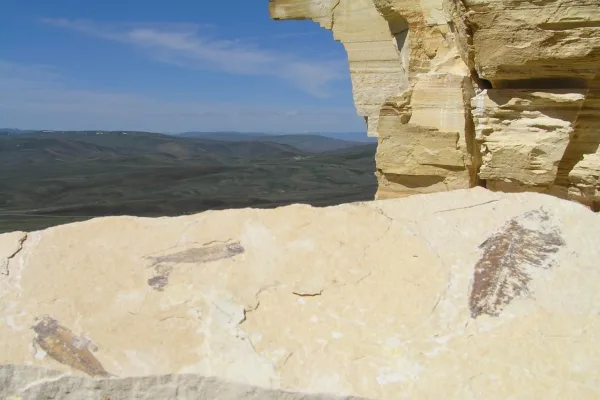
Fossil Butte National Monument
National Monument
In the ridges of southwest Wyoming are some of the best-preserved fossils in the world. They tell the story of ancient life in a warm, wet environment in and around a freshwater lake. Stingrays swam i...
12 mi from route
~31 min detour
Free
near mile 292.9
Park data from the National Park Service API. Alerts update every 2 hours.
More Details
What kind of drive is this?
Expect a drive defined by a significant, long-haul stretch followed by tighter local segments. You will spend the vast majority of your time on the Dwight D. Eisenhower Highway, which accounts for a 243.3-mile uninterrupted stretch of the journey. While 16 percent of the trip involves highway travel, the overall profile is characterized by a turn-heavy local drive as you transition off the main arteries. The road transitions from fast, open highway miles to more technical navigation as you near your destination. Be prepared for this shift in pace, as the experience behind the wheel changes significantly once you leave the primary highway corridor.
Only 16% highway — the rest is turn-by-turn surface driving.
17 navigation steps total — most of the decisions cluster near the start and finish.
Longest single stretch: 243.3 mi on Dwight D. Eisenhower Highway.
How Hard Is This Drive?
3/10
Expect a hands-on drive with frequent turns and local roads rather than long highway stretches. There are only a few real navigation decisions along the way. The trickiest moment comes early in the drive near South 5th Street.
Driving Effort3/10
Easy - simple navigation with a manageable amount of wheel time
Balances navigation complexity with total wheel time.
This is a straightforward 5h drive. You will face about 11 decision points, but nothing that requires special attention if you follow navigation.
Where does it get tricky?
The main spots that need attention: near the start (South 5th Street): Navigation decision point; near the start (I 80 Business; US 30 / East Grand Avenue): Navigation decision point; at 2.4 miles: Lane positioning matters here.
Elevation Profile
High-altitude sections with notable climbs
7,839 ft6,286 ft
Total Climb
2,072 ft
Total Descent
2,284 ft
Highest Point
7,839 ft
~41.8 mi in
Elevation Range
1,553 ft
Notable High Points
7,839 ft at ~41.8 miles+555 ft prominence
7,065 ft at ~125.5 miles+67 ft prominence
6,867 ft at ~167.4 miles+132 ft prominence
6,425 ft at ~230.2 miles+43 ft prominence
Towns Mentioned on Route Signs
Based on OSRM destination-sign hints, not a full list of every settlement the road passes.
On the drive from Laramie, WY to Kemmerer, WY, road signs begin pointing toward Pocatello along the way.
Mostly surface roads route profile with national parks nearby.
Frequently Asked Questions
The longest stretch is about 243.3 miles on Dwight D. Eisenhower Highway. The full list of main roads is in the Roads section above.
Yes — we found about 12 rest areas or service plazas within a short detour of the route (from OpenStreetMap). See the Rest Stops tab under Nearby Places for locations and mile markers. Plan to stretch, use the bathroom, and top off fluids every 2–3 hours on longer drives.
Only with planning. This is a long drive for kids — consider splitting it into two days rather than pushing through. Plan at least 1 meaningful breaks. There are 12 rest areas along the route for bathroom stops.
Mostly yes along the main roads, but rural stretches through WY can have sparse or no coverage. Before you leave, download offline Google Maps or Apple Maps for the route, and consider downloading music or podcasts instead of streaming. If you depend on data for navigation, keep a paper backup of the turn-by-turn directions.
The main spots that need attention: near the start (South 5th Street): Navigation decision point; near the start (I 80 Business; US 30 / East Grand Avenue): Navigation decision point; at 2.4 miles: Lane positioning matters here.
Yes — Fossil Butte National Monument. See the National Parks section for detour distances and tips on detours.
Not recommended in a single day. At 5.0 hours each way, a round trip means 10.0 hours of driving — that is an unsafe level of fatigue for most drivers. Plan at least one night at Kemmerer, WY before the return drive.