If you are planning a trip from Glastonbury to North Stamford, expect a straightforward journey covering 73.7 miles. This drive typically takes about 1 hour and 37 minutes, making it a perfect candidate for a single-day excursion. You will spend the vast majority of your time on major corridors, specifically I-91, CT-3, and CT-15. With an estimated fuel cost of $12, it is an economical route that requires little in terms of logistical overhead. Because this trip stays entirely within the Northeast region of Connecticut, you will find the infrastructure consistent and easy to navigate. It is a highly efficient connector for travelers looking to move between these two points without the need for an overnight stay.
Trip Pace
Same-day drive is realistic
A same-day return is realistic if you keep stops short.
Midpoint
36.9 miles from Glastonbury, CT
A natural place for your longest stop of the day
, about 48m into the drive
.
Main Roads
Road
Distance
Duration
CT 15
53.8 mi
1h 8m
I 91
13.3 mi
15m
CT 3
1.7 mi
2m
High Ridge Road
1.6 mi
2m
Main Street
1 mi
2m
Putnam Boulevard
0.3 mi
<1m
North Stamford Road
0.3 mi
1m
Cascade Road
<0.1 mi
<1m
Longest stretch:
CT 15
— 53.8 mi, about 1h 8m
Turn-by-Turn Driving Directions
Step-by-step road directions between Glastonbury, CT and North Stamford, CT.
1
Start on Hebron Avenue
129 ft·7 sec·Hebron Avenue
2
Turn right onto Main Street
1.0 mi·2 min·Main Street
Use the straight / right lanes.
3
Turn left onto Putnam Boulevard
0.3 mi·53 sec·Putnam Boulevard
4
Take the ramp
0.2 mi·25 sec
Toward CT 3 South: Wethersfield
5
Merge onto CT 3
1.7 mi·2 min·CT 3
Use the straight / slight right lanes.
6
Take the exit
0.7 mi·1 min
Toward I 91 South: New HavenUse the straight / slight left lanes.
7
Merge onto I 91
13 mi·15 min·I 91
Use the straight / slight right lanes.
8
Take the exit
0.3 mi·34 sec
Exit 17Toward CT 15 SouthUse the slight right lane.
9
Keep slight left at fork
437 ft·8 sec
Toward CT 15 SouthUse the straight / slight right lanes.
10
Merge onto CT 15
54 mi·1 hr 8 min·CT 15
Use the straight / slight right lanes.
11
Take the exit
0.4 mi·1 min
Exit 10Toward CT 137: High Ridge RoadUse the straight / right lanes.
12
Turn left onto CT 137
1.6 mi·2 min·High Ridge Road
Use the straight lane.
13
Turn right onto North Stamford Road
0.2 mi·54 sec·North Stamford Road
14
Continue on North Stamford Road
475 ft·16 sec·North Stamford Road
15
Turn slight right onto Cascade Road
139 ft·6 sec·Cascade Road
16
Arrive at destination
Cascade Road
Trip Plan
To ensure the smoothest experience, plan your departure around local traffic patterns, as the heavy reliance on highways means congestion can fluctuate quickly. Since the entire trip takes less than two hours, you likely won't need a formal rest stop, though staying flexible with your timing is a major advantage for such a short duration. Keep your $12 fuel budget in mind before you head out so you can focus on the drive rather than hunting for stations mid-transit. A concrete tip for this route: since you spend 53.8 miles on CT-15, verify your navigation settings before leaving Glastonbury to ensure you stay on the intended highway path throughout the longest segment of your journey.
Morning Departure
Leave by 9 AM and you'll arrive before lunch.
Evening Departure
Even a 4 PM departure gets you there before dark in summer.
You can normally do this drive in one day.
You may only need one short stretch break if traffic stays light.
The halfway point lands around 36.9 miles from Glastonbury, CT, or about 48m into the drive.
The longest continuous stretch on this route runs about 53.8 miles.
This is a comfortable same-day trip.
Departure
Before you leave
Start with fuel, water, and navigation already sorted so the first hour feels easy.
First stop
Around 16 miles or 21m in
Use this first pause for coffee, a restroom break, and a quick traffic check ahead.
Halfway reset
Around 36.9 miles or 48m in
This is the best place for your longest stop, a real meal, and a full fuel check.
Final approach
Final hour starts around 1h 20m
Traffic, exits, and arrival timing usually matter more near North Stamford, CT than in the middle of the route.
Before You Leave
+
Open the route before leaving Glastonbury, CT so your first major turns are already loaded.
Day 1
Settle into the route from Glastonbury, CT
This is one driving day of about 73.7 miles and 1h 37m.
Your first comfortable stop window is around 16 miles from Glastonbury, CT.
This route can stay practical as a one-day drive if traffic stays reasonable.
The longest stretch is on CT 15 for about 53.8 miles.
Where to Stop
Rest stops, refuel points, and overnight suggestions along this route.
Place data sourced from public business listings. Hours and availability may vary.
Heads-up: tricky spots
5 of 13
5 decision points cluster between mile 1.3 and 71.4 — GPS handles the exact turns, but know they're coming. Your lane choice matters more than the turn itself.
6
1.3 mi into trip|~3m in
Take the ramp toward CT 3 South: Wethersfield
Complex interchange - multiple decisions in a short stretch
Toward CT 3 South: Wethersfield
6
3.2 mi into trip|~6m in
Take the exit toward I 91 South: New Haven
Exit ramp - move to the correct lane early. Lane positioning matters here
Use the straight / slight left lanes.
Toward I 91 South: New Haven
7
17.2 mi into trip|~23m in
Take the exit toward CT 15 South
Exit ramp - move to the correct lane early. Lane positioning matters here
Use the slight right lane.
Exit 17
Toward CT 15 South
7
17.6 mi into trip|~23m in
Keep slight left at fork toward CT 15 South
Highway fork - watch signs carefully. Lane positioning matters here
Use the straight / slight right lanes.
Toward CT 15 South
7
71.4 mi into trip|~1h 31m in
Take the exit toward CT 137: High Ridge Road
Exit ramp - move to the correct lane early. Lane positioning matters here
Use the straight / right lanes.
Exit 10
Toward CT 137: High Ridge Road
Fuel & Cost
Regular Gas
$11.86 one way
$23.73 round trip
$4.09/gal25.4 MPG avg26 kg CO2
Fuel Type
$/gal
One Way
Round Trip
midgrade
$4.50
$13.05
$26.11
premium
$4.86
$14.11
$28.23
diesel
$5.61
$16.27
$32.54
No toll roads detected on this route.
Estimated Trip Cost (one way, 1 person)
Fuel
$12
Meals
$25–$50
Total
$37–$62
Rough estimate based on US averages. Hotel $80–$140/night, meals $25–$50/day.
Estimated CO2 emission: 25.8 kg one way.
Prices: EIA weekly data, 2026-04-13.
Driving Electric?
About $8 in charging
· 0 stops
· 65% less CO2
Vehicle Type
kWh
Stops
DC Fast
Home Charge
Average EV
22.1
0
$7.74
$3.54
Efficient EV
18.4
0
$6.45
$2.95
EV Truck/SUV
29.5
0
$10.32
$4.72
Gas CO2
26 kg
EV CO2
9 kg (65% less)
This trip is well within single-charge range for most EVs. No charging stops needed if you start fully charged.
DC fast charging avg $0.35/kWh. Home charging avg $0.16/kWh. US grid CO2: 0.39 kg/kWh.
Travel Intel
Current conditions at both ends of the drive.
Forecast as of Jun 20, 2022
Origin
Glastonbury, CT
Late night
in Glastonbury on Sunday
Local time
12:44 AM
EDT
Current temp
65°F
Unavailable
Live forecast
Destination
North Stamford, CT
Late night
in North Stamford on Sunday
Local time
12:44 AM
EDT
Current temp
44°F
Unavailable
Live forecast
Seasonal Notes
Summer travel usually means heavier construction, hotter rest stops, and busier weekend traffic around major cities.
Winter travel shortens daylight, so a route that looks manageable on paper can feel much longer after dark.
Holiday weekends tend to make both departure and arrival windows slower than the raw route time suggests.
Time zone
Same local time
Origin and destination are on the same clock, so arrival timing is easier to judge at a glance.
Temperature spread
21 degrees cooler at arrival
A meaningful temperature swing is a good cue to rethink layers, water, and how soon you want to arrive.
Road read
1h 37m on the road
Use the two city cards together: check the sky where you start, then compare it with the local time and temperature at arrival.
Weather data from the National Weather Service. Conditions may change; check closer to your travel date.
National Parks Near This Route
Worth a detour if your schedule allows.
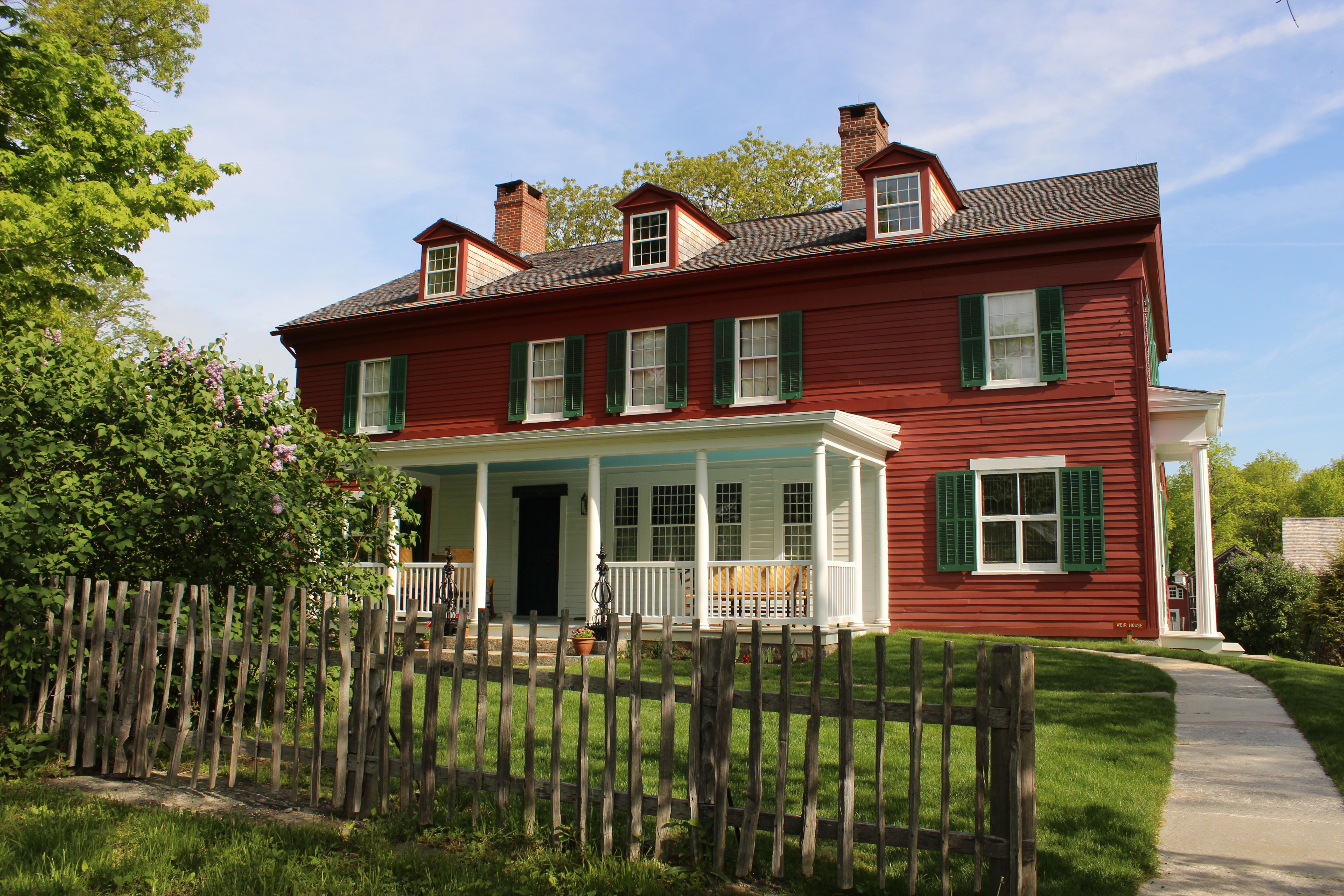
Weir Farm National Historical Park
National Historical Park
Visit the home and studio of America's most beloved Impressionist, J. Alden Weir, and walk in the footsteps of generations of world-class artists. Set amidst more than 60 acres of painterly woods, fie...
8 mi from route
~20 min detour
Free
near mile 63.6
Park data from the National Park Service API. Alerts update every 2 hours.
More Details
What kind of drive is this?
This is a highway-focused drive, with 93% of your time spent on high-speed roads. You will settle into a rhythm quickly, as the route features a significant 53.8-mile uninterrupted stretch along CT-15. While the transition between I-91 and the state routes keeps you moving, the experience is defined by a steady, consistent pace rather than technical winding roads. Expect a functional transit experience where the focus is on maintaining momentum across the Connecticut landscape. By keeping your eyes on the road and following the primary highway signage, you can expect a predictable ride from start to finish.
93% highway — fuel and pacing are the main things to plan.
16 navigation steps total — most of the decisions cluster near the start and finish.
Longest single stretch: 53.8 mi on CT 15.
How Hard Is This Drive?
8/10
This is a straightforward highway drive that stays mostly on CT 15 and I 91. This route has several spots where lane changes, forks, or exits need your full attention. The trickiest moment comes around 1.3 miles in.
Driving Effort8/10
Demanding - plan breaks and stay ahead of the key maneuvers
Balances navigation complexity with total wheel time.
This drive requires moderate attention. Across 73.7 miles you will encounter 13 spots where lane choice or exit timing matters. Not difficult for experienced highway drivers, but worth previewing the tricky sections before you go.
Where does it get tricky?
The main spots that need attention: at 1.3 miles: Complex interchange - multiple decisions in a short stretch; at 3.2 miles: Exit ramp - move to the correct lane early. Lane positioning matters here; at 17.2 miles: Exit ramp - move to the correct lane early. Lane positioning matters here.
Elevation Profile
Mostly flat terrain
390 ft22 ft
Total Climb
896 ft
Total Descent
725 ft
Highest Point
390 ft
~15.8 mi in
Elevation Range
368 ft
Who Is This Route For?
Weekend Trip
Doable as a same-day drive at 1h 37m. Total distance: 73.7 miles.
Family Friendly
Moderate complexity with 0 natural rest stops along the way.
Solo Traveler
1h 37m drive, comfortable solo distance.
First-Time Driver
Mostly highway driving (93%). Some complex stretches to watch for.
Frequently Asked Questions
The longest stretch is about 53.8 miles on CT 15. The full list of main roads is in the Roads section above.
It helps. This route has a higher-than-average number of complex decision points, which get harder in the dark. If the last hour of the trip is on surface roads or mountain grades, aim to arrive at North Stamford, CT before sunset when you can. Check the Trip Plan for departure windows that land you in daylight.
Yes. At under 2 hours behind the wheel, this works well for families — plan one quick stop if you have younger kids.
The main spots that need attention: at 1.3 miles: Complex interchange - multiple decisions in a short stretch; at 3.2 miles: Exit ramp - move to the correct lane early. Lane positioning matters here; at 17.2 miles: Exit ramp - move to the correct lane early. Lane positioning matters here.
Yes — Weir Farm National Historical Park. See the National Parks section for detour distances and tips on detours.
Yes. A round trip is manageable in a single day if you plan a break at North Stamford, CT before heading back.