Gearhart to Bend is 249.4 miles and takes about 5h 32m via North Santiam Highway and I-5, with a fuel budget near $50 and enough daylight to finish in a day. This trip takes you from the Pacific Coast region inland towards the high desert, offering a change of scenery as you leave the coast behind. With a highway share of only 25%, much of this drive involves cruising on surface roads. It's a straightforward one-day trip that should be manageable for most drivers.
Trip Pace
Same-day drive is realistic
A same-day return is possible, but it will make for a full day on the road.
Break Rhythm
1 planned break
Plan on a short reset every 3 to 4 hours to stay fresh behind the wheel.
Midpoint
124.7 miles from Gearhart, OR
A natural place for your longest stop of the day
, about 2h 43m into the drive
.
Main Roads
Road
Distance
Duration
North Santiam Highway
104.3 mi
2h 18m
I 5
37.6 mi
44m
Sunset Highway
35.1 mi
44m
Northwest Sunset Highway
33.8 mi
46m
US 20
15 mi
18m
Beaverton-Tigard Freeway
6.8 mi
9m
North Roosevelt Drive
5.1 mi
9m
McKenzie-Bend Highway
4 mi
5m
Longest stretch:
North Santiam Highway
— 104.3 mi, about 2h 18m
Traffic on I-5
Hour-of-day weekday pattern from 15 FHWA count stations on your route.
Peak
3 PM
~4,398 veh/hr typical
Quietest
2 AM
~347 veh/hr
Peak-to-quiet ratio
12.7×
busier at peak than in the quiet hours
12a6anoon6p11p
Averaged across 45 weeks of 2023 FHWA Travel Monitoring Analysis System data. Weekday hours only (Mon–Fri).
Turn-by-Turn Driving Directions
Step-by-step road directions between Gearhart, OR and Bend, OR.
1
Start on Pacific Way
106 ft·11 sec·Pacific Way
2
Turn left onto US 101
0.8 mi·1 min·Park Avenue
3
Continue on US 101
0.1 mi·13 sec·Oregon Coast Highway
4
Continue on US 101
5.1 mi·9 min·North Roosevelt Drive
Use the straight / right lanes.
5
Take the exit
0.2 mi·16 sec
Toward US 26 East: Portland
6
Continue on US 26
35 mi·44 min·Sunset Highway
Use the straight lane.
7
Continue on US 26
14 mi·19 min·Northwest Sunset Highway
Use the left / straight lanes.
8
Continue on US 26
20 mi·26 min·Northwest Sunset Highway
Use the left / straight / right lanes.
9
Take the exit
0.3 mi·44 sec
Exit 69AToward OR 217 South: Tigard, SalemUse the straight / slight right lanes.
10
Merge onto OR 217
6.8 mi·9 min·Beaverton-Tigard Freeway
Use the straight / slight right lanes.
11
Take the exit
0.5 mi·43 sec
Toward I 5 South: SalemUse the straight / slight right lanes.
12
Merge onto I 5
38 mi·44 min·I 5
Use the straight / slight right lanes.
13
Take the exit
0.2 mi·19 sec
Exit 253Toward OR 22, OR 99E Business: Detroit Lake, Bend
14
Keep slight left at fork
0.1 mi·17 sec
15
Turn left onto OR 22; OR 99E Bus
28 mi·32 min·North Santiam Highway
Use the left lane.
16
Continue on OR 22
0.6 mi·43 sec·Northwest Santiam Boulevard
17
Continue on OR 22
0.5 mi·33 sec·Northeast Santiam Boulevard
18
Continue on OR 22
76 mi·1 hr 45 min·North Santiam Highway
19
Enter roundabout onto West Barclay Drive
226 ft·3 sec·West Barclay Drive
20
Continue on West Barclay Drive
0.8 mi·1 min·West Barclay Drive
21
At end of road, turn right onto North Locust Street
0.5 mi·51 sec·North Locust Street
22
Enter roundabout onto US 20; OR 126
248 ft·3 sec·US 20; OR 126
23
Continue on US 20; OR 126
15 mi·18 min·US 20; OR 126
24
Enter roundabout onto US 20
133 ft·1 sec·McKenzie-Bend Highway
25
Continue on US 20
2.0 mi·3 min·McKenzie-Bend Highway
26
Enter roundabout onto US 20
127 ft·1 sec·McKenzie-Bend Highway
27
Continue on US 20
0.7 mi·1 min·McKenzie-Bend Highway
28
Enter roundabout onto US 20
130 ft·1 sec·McKenzie-Bend Highway
29
Continue on US 20
0.4 mi·36 sec·McKenzie-Bend Highway
30
Enter roundabout onto US 20
118 ft·1 sec·McKenzie-Bend Highway
31
Continue on US 20
0.8 mi·57 sec·McKenzie-Bend Highway
32
Turn straight onto US 20; US 97 Business
439 ft·13 sec·Northeast 3rd Street
33
Turn left onto Empire Avenue
0.2 mi·20 sec·Empire Avenue
34
Take the exit
0.3 mi·32 sec
35
Merge onto US 97
1.8 mi·3 min·Bend Parkway
Use the straight / slight right lanes.
36
Turn right onto Northwest Lafayette Avenue
0.2 mi·45 sec·Northwest Lafayette Avenue
37
At end of road, turn left onto Northwest Wall Street
0.4 mi·1 min·Northwest Wall Street
38
Turn right onto Northwest Franklin Avenue
54 ft·2 sec·Northwest Franklin Avenue
39
Arrive at destination
Northwest Franklin Avenue
Trip Plan
Aim to depart Gearhart in the morning to take advantage of the full daylight hours for your 5h 32m drive. While this trip can be completed in a single day, consider an early start to allow for a relaxed pace. The longest stretch without major road changes is 104.3 miles on North Santiam Highway, so plan your fuel and rest stops accordingly. Given the $50 fuel estimate, it’s wise to fill up before leaving the coast to ensure you have enough for the entire journey.
Morning Departure
An early start around 7-8 AM gets you there with plenty of daylight left.
Evening Departure
A late afternoon start means arriving after dark. Morning is better.
You can normally do this drive in one day.
Plan roughly 1 meaningful break for fuel, food, and rest.
The halfway point lands around 124.7 miles from Gearhart, OR, or about 2h 43m into the drive.
The longest continuous stretch on this route runs about 104.3 miles.
This is a comfortable same-day trip.
Departure
Before you leave
Start with fuel, water, and navigation already sorted so the first hour feels easy.
First stop
Around 55 miles or 1h 15m in
Use this first pause for coffee, a restroom break, and a quick traffic check ahead.
Halfway reset
Around 124.7 miles or 2h 43m in
This is the best place for your longest stop, a real meal, and a full fuel check.
Final approach
Final hour starts around 4h 28m
Traffic, exits, and arrival timing usually matter more near Bend, OR than in the middle of the route.
Before You Leave
+
Open the route before leaving Gearhart, OR so your first major turns are already loaded.
+
Leave with enough water and a charging cable within reach, not packed away.
+
Check your fuel range against the first long segment, especially if you are starting outside city service areas.
Day 1
Settle into the route from Gearhart, OR
This is one driving day of about 249.4 miles and 5h 32m.
Your first comfortable stop window is around 55 miles from Gearhart, OR.
This route can stay practical as a one-day drive if traffic stays reasonable.
Plan about 1 real break rather than only quick fuel stops.
The longest stretch is on North Santiam Highway for about 104.3 miles.
Where to Stop
Rest stops, refuel points, and overnight suggestions along this route.
Place data sourced from public business listings. Hours and availability may vary.
Heads-up: tricky spots
5 of 22
5 decision points cluster between mile 75.1 and 120.3 — GPS handles the exact turns, but know they're coming. Your lane choice matters more than the turn itself.
8
75.1 mi into trip|~1h 42m in
Take the exit toward OR 217 South: Tigard, Salem
Exit ramp - move to the correct lane early. Lane positioning matters here. Multiple destination signs - pick the right one
Use the straight / slight right lanes.
Exit 69A
Toward OR 217 South: Tigard, Salem
5
75.4 mi into trip|~1h 43m in|OR 217 / Beaverton-Tigard Freeway
Merge onto OR 217 / Beaverton-Tigard Freeway
Merge point - match speed before joining. Lane positioning matters here
Use the straight / slight right lanes.
6
82.3 mi into trip|~1h 52m in
Take the exit toward I 5 South: Salem
Exit ramp - move to the correct lane early. Lane positioning matters here
Use the straight / slight right lanes.
Toward I 5 South: Salem
5
82.8 mi into trip|~1h 53m in|I 5
Merge onto I 5
Merge point - match speed before joining. Lane positioning matters here
Use the straight / slight right lanes.
6
120.3 mi into trip|~2h 38m in
Take the exit toward OR 22, OR 99E Business: Detroit Lake, Bend
Exit ramp - move to the correct lane early. Multiple destination signs - pick the right one
Exit 253
Toward OR 22, OR 99E Business: Detroit Lake, Be...
Fuel & Cost
Regular Gas
$44.19 one way
$88.39 round trip
$4.50/gal25.4 MPG avg87 kg CO2
Fuel Type
$/gal
One Way
Round Trip
midgrade
$4.82
$47.33
$94.65
premium
$5.04
$49.51
$99.01
diesel
$4.80
$47.09
$94.18
No toll roads detected on this route.
Estimated Trip Cost (one way, 1 person)
Fuel
$44
Meals
$25–$50
Total
$69–$94
Rough estimate based on US averages. Hotel $80–$140/night, meals $25–$50/day.
Estimated CO2 emission: 87.3 kg one way.
Prices: EIA weekly data, 2026-07-13.
Driving Electric?
About $26 in charging
· 0 stops
· 67% less CO2
Vehicle Type
kWh
Stops
DC Fast
Home Charge
Average EV
74.8
0
$26.19
$11.97
Efficient EV
62.4
0
$21.82
$9.98
EV Truck/SUV
99.8
1
$34.92
$15.96
Gas CO2
87 kg
EV CO2
29 kg (67% less)
Plan for 0 charging stops, roughly every 270 miles. Allow 25-40 minutes per stop at a DC fast charger.
DC fast charging avg $0.35/kWh. Home charging avg $0.16/kWh. US grid CO2: 0.39 kg/kWh.
Travel Intel
Current conditions at both ends of the drive.
Forecast as of Jul 18, 2026
Origin
Gearhart, OR
Late night
in Gearhart on Sunday
Local time
2:37 AM
PDT
Current temp
54°F
Areas Of Fog
0 mph0% chanceLive forecast
Red Flag Warning
Red Flag Warning issued July 18 at 4:30AM PDT until July 18 at 10:00PM PDT by NWS Pendleton OR
Destination
Bend, OR
Late night
in Bend on Sunday
Local time
2:37 AM
PDT
Current temp
53°F
Patchy Smoke
SW 2 mph0% chanceLive forecast
Red Flag Warning
Red Flag Warning issued July 18 at 4:30AM PDT until July 18 at 10:00PM PDT by NWS Pendleton OR
84°F
Salem, OR
125 mi in
Seasonal Notes
Summer travel usually means heavier construction, hotter rest stops, and busier weekend traffic around major cities.
Winter travel shortens daylight, so a route that looks manageable on paper can feel much longer after dark.
Holiday weekends tend to make both departure and arrival windows slower than the raw route time suggests.
Time zone
Same local time
Origin and destination are on the same clock, so arrival timing is easier to judge at a glance.
Temperature spread
1 degrees cooler at arrival
A meaningful temperature swing is a good cue to rethink layers, water, and how soon you want to arrive.
Road read
5h 32m on the road
An early start around 7-8 AM gets you there with plenty of daylight left.
Weather data from the National Weather Service. Conditions may change; check closer to your travel date.
National Parks Near This Route
Worth a detour if your schedule allows.
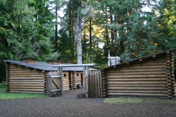
Lewis and Clark National Historical Park
National Historical Park
Explore the timeless rainforests and majestic coastal vistas. Discover the rich heritage of the native people. Unfold the dramatic stories of America's most famous explorers. The park encompasses site...
Park data from the National Park Service API. Alerts update every 2 hours.
More Details
What kind of drive is this?
This drive is mostly surface roads, with highways making up 25% of the total mileage. You'll experience a significant stretch of 104.3 miles on the North Santiam Highway before transitioning to other roads. Expect a mix of rural cruising and potentially some urban merging as you navigate between highways and local routes. The bulk of your time will be spent on non-highway driving.
Only 25% highway — the rest is turn-by-turn surface driving.
39 navigation steps total — most of the decisions cluster near the start and finish.
Longest single stretch: 104.3 mi on North Santiam Highway.
How Hard Is This Drive?
7/10
Expect a hands-on drive with frequent turns and local roads rather than long highway stretches. This route has several spots where lane changes, forks, or exits need your full attention. The trickiest moment comes around 75.1 miles in.
Driving Effort7/10
Demanding - plan breaks and stay ahead of the key maneuvers
Balances navigation complexity with total wheel time.
This is a demanding drive. With 22 significant decision points across 249.4 miles, you will need to stay alert - especially through interchange areas and urban stretches. Consider splitting it into segments if you are not comfortable with fast highway navigation.
Where does it get tricky?
The main spots that need attention: at 75.1 miles: Exit ramp - move to the correct lane early. Lane positioning matters here. Multiple destination signs - pick the right one; at 75.4 miles (OR 217 / Beaverton-Tigard Freeway): Merge point - match speed before joining. Lane positioning matters here; at 82.3 miles: Exit ramp - move to the correct lane early. Lane positioning matters here.
Elevation Profile
High-altitude sections with notable climbs
3,683 ft23 ft
Total Climb
5,414 ft
Total Descent
1,812 ft
Highest Point
3,683 ft
~196 mi in
Elevation Range
3,660 ft
Notable High Points
1,523 ft at ~35.6 miles+625 ft prominence
Towns Mentioned on Route Signs
Based on OSRM destination-sign hints, not a full list of every settlement the road passes.
On the drive from Gearhart, OR to Bend, OR, road signs begin pointing toward Salem along the way.
Doable as a same-day drive at 5h 32m. Total distance: 249.4 miles.
Family Friendly
Moderate complexity with 1 natural rest stops along the way.
Solo Traveler
5h 32m drive, comfortable solo distance.
Scenic Drive
Mostly surface roads route profile with national parks nearby.
Frequently Asked Questions
The longest stretch is about 104.3 miles on North Santiam Highway. The full list of main roads is in the Roads section above.
Yes — we found about 12 rest areas or service plazas within a short detour of the route (from OpenStreetMap). See the Rest Stops tab under Nearby Places for locations and mile markers. Plan to stretch, use the bathroom, and top off fluids every 2–3 hours on longer drives.
It helps. This route has a higher-than-average number of complex decision points, which get harder in the dark. If the last hour of the trip is on surface roads or mountain grades, aim to arrive at Bend, OR before sunset when you can. Check the Trip Plan for departure windows that land you in daylight.
Only with planning. This is a long drive for kids — consider splitting it into two days rather than pushing through. Plan at least 1 meaningful breaks. There are 12 rest areas along the route for bathroom stops.
The main spots that need attention: at 75.1 miles: Exit ramp - move to the correct lane early. Lane positioning matters here. Multiple destination signs - pick the right one; at 75.4 miles (OR 217 / Beaverton-Tigard Freeway): Merge point - match speed before joining. Lane positioning matters here; at 82.3 miles: Exit ramp - move to the correct lane early. Lane positioning matters here.
Yes — Lewis and Clark National Historical Park. See the National Parks section for detour distances and tips on detours.
Not recommended in a single day. At 5.5 hours each way, a round trip means 11.1 hours of driving — that is an unsafe level of fatigue for most drivers. Plan at least one night at Bend, OR before the return drive.