Traveling from Benzonia to Ann Arbor covers 236 miles and typically takes about 3 hours and 53 minutes. Given the duration, this trip is perfectly manageable as a single-day journey, though you should budget roughly $36 for fuel to complete the trek. You will primarily navigate via Benzie Highway, Cadillac Highway, and West M-115 Highway as you transition through the heart of the Midwest. Because this route relies on local roads rather than interstates, it offers a more grounded travel experience through Michigan. Whether you are heading home or exploring a new city, the drive is straightforward enough to complete without an overnight stop. It provides a direct connection between these two Michigan locales, making it a practical choice for a quick getaway.
Trip Pace
Same-day drive is realistic
A same-day return is possible, but it will make for a full day on the road.
Break Rhythm
1 planned break
Plan on a short reset every 3 to 4 hours to stay fresh behind the wheel.
Midpoint
117.9 miles from Benzonia, MI
A natural place for your longest stop of the day
, about 2h 25m into the drive
.
Main Roads
Road
Distance
Duration
West M-115 Highway
61.4 mi
1h 23m
US 10
57 mi
57m
I 75
47.3 mi
50m
US 23
45.4 mi
48m
Cadillac Highway
17.8 mi
20m
US 23 BUS
2.4 mi
3m
Benzie Highway
1.6 mi
2m
Michigan Avenue
0.8 mi
1m
Longest stretch:
West M-115 Highway
— 61.4 mi, about 1h 23m
Traffic on I-75
Hour-of-day weekday pattern from 44 FHWA count stations on your route.
Peak
3 PM
~2,446 veh/hr typical
· worst 3,656
Quietest
2 AM
~135 veh/hr
Peak-to-quiet ratio
18.1×
busier at peak than in the quiet hours
12a6anoon6p11p
Averaged across 52 weeks of 2023 FHWA Travel Monitoring Analysis System data. Weekday hours only (Mon–Fri).
Turn-by-Turn Driving Directions
Step-by-step road directions between Benzonia, MI and Ann Arbor, MI.
1
Start on US 31
0.8 mi·1 min·Michigan Avenue
2
Continue on US 31; M 115
1.6 mi·2 min·Benzie Highway
3
Turn left onto M 115
18 mi·20 min·Cadillac Highway
4
Continue on M 115
5.3 mi·6 min·West M-115 Highway
5
Continue on M 37; M 115
0.6 mi·1 min·West Mesick Avenue
6
Continue on M 37; M 115
0.5 mi·50 sec·West M-115 Highway
7
Enter roundabout onto M 115
129 ft·1 sec·West M-115 Highway
8
Continue on M 115
354 ft·5 sec·West M-115 Highway
9
Merge onto M 115
55 mi·1 hr 16 min·West M-115 Highway
10
Take the exit
0.3 mi·50 sec
Toward US 10 East: Clare
11
Merge onto US 10
11 mi·10 min·US 10
12
Take the exit onto US 10
46 mi·46 min·US 10
Toward US 10 EAST: Midland, Bay City
13
Take the exit
0.4 mi·38 sec
Exit 140AToward I 75 South, US 23 South: Saginaw
14
Merge onto I 75; US 23
36 mi·38 min·I 75; US 23
15
Keep slight left at fork onto I 75; US 23
11 mi·11 min·I 75; US 23
16
Keep slight right at fork onto US 23
45 mi·48 min·US 23
Toward US 23: Ann ArborUse the straight / slight right lanes.
17
Take the exit onto US 23 BUS
1.5 mi·1 min·US 23 BUS
Exit 45Toward M 14 West: Ann ArborUse the straight / slight right lanes.
18
Take the exit onto US 23 BUS
0.9 mi·1 min·US 23 BUS
Exit 3Toward US 23 BUS: Downtown Ann ArborUse the slight right lane.
19
Turn left onto Depot Street
0.4 mi·1 min·Depot Street
Use the left lane.
20
Turn right
119 ft·6 sec
21
Continue on North State Street
0.6 mi·1 min·North State Street
Use the straight / right lanes.
22
Arrive at destination
South State Street
Trip Plan
Since this is a sub-four-hour trip, you have plenty of flexibility to plan your departure around your personal schedule. Consider building in at least one planned stop to break up the technical, turn-heavy sections of the drive and keep yourself fresh behind the wheel. Given the reliance on state highways, keep a close eye on your fuel gauge before leaving Benzonia, as local roads may have fewer service stations than major interstates. If you find the winding roads tiring, aim to start your trip in the morning to maximize daylight hours for navigating the turns. Use that one scheduled stop to stretch your legs, as the continuous maneuvering on M-115 can be more demanding than a standard freeway cruise.
Morning Departure
An early start around 7-8 AM gets you there with plenty of daylight left.
Evening Departure
A late afternoon start means arriving after dark. Morning is better.
You can normally do this drive in one day.
Plan roughly 1 meaningful break for fuel, food, and rest.
The halfway point lands around 117.9 miles from Benzonia, MI, or about 2h 25m into the drive.
The longest continuous stretch on this route runs about 61.4 miles.
This is a comfortable same-day trip.
Departure
Before you leave
Start with fuel, water, and navigation already sorted so the first hour feels easy.
First stop
Around 52 miles or 1h 7m in
Use this first pause for coffee, a restroom break, and a quick traffic check ahead.
Halfway reset
Around 117.9 miles or 2h 25m in
This is the best place for your longest stop, a real meal, and a full fuel check.
Final approach
Final hour starts around 3h 45m
Traffic, exits, and arrival timing usually matter more near Ann Arbor, MI than in the middle of the route.
Before You Leave
+
Open the route before leaving Benzonia, MI so your first major turns are already loaded.
+
Leave with enough water and a charging cable within reach, not packed away.
+
Check your fuel range against the first long segment, especially if you are starting outside city service areas.
Day 1
Settle into the route from Benzonia, MI
This is one driving day of about 235.9 miles and 4h 33m.
Your first comfortable stop window is around 52 miles from Benzonia, MI.
This route can stay practical as a one-day drive if traffic stays reasonable.
Plan about 1 real break rather than only quick fuel stops.
The longest stretch is on West M-115 Highway for about 61.4 miles.
Where to Stop
Rest stops, refuel points, and overnight suggestions along this route.
Place data sourced from public business listings. Hours and availability may vary.
Heads-up: tricky spots
5 of 14
5 decision points cluster between mile 93.3 and 234 — GPS handles the exact turns, but know they're coming. Your lane choice matters more than the turn itself.
5
93.3 mi into trip|~2h 1m in|US 10
Take the exit onto US 10 toward US 10 EAST: Midland, Bay City
Exit ramp - move to the correct lane early. Multiple destination signs - pick the right one
Toward US 10 EAST: Midland, Bay City
6
139.4 mi into trip|~2h 47m in
Take the exit toward I 75 South, US 23 South: Saginaw
Exit ramp - move to the correct lane early. Multiple destination signs - pick the right one
Exit 140A
Toward I 75 South, US 23 South: Saginaw
7
187 mi into trip|~3h 38m in|US 23
Keep slight right at fork onto US 23 toward US 23: Ann Arbor
Highway fork - watch signs carefully. Lane positioning matters here
Use the straight / slight right lanes.
Toward US 23: Ann Arbor
7
232.4 mi into trip|~4h 27m in|US 23 BUS
Take the exit onto US 23 BUS toward M 14 West: Ann Arbor
Exit ramp - move to the correct lane early. Lane positioning matters here
Use the straight / slight right lanes.
Exit 45
Toward M 14 West: Ann Arbor
7
234 mi into trip|~4h 28m in|US 23 BUS
Take the exit onto US 23 BUS toward US 23 BUS: Downtown Ann Arbor
Exit ramp - move to the correct lane early. Lane positioning matters here
Use the slight right lane.
Exit 3
Toward US 23 BUS: Downtown Ann Arbor
Fuel & Cost
Regular Gas
$34.84 one way
$69.67 round trip
$3.75/gal25.4 MPG avg83 kg CO2
Fuel Type
$/gal
One Way
Round Trip
midgrade
$4.14
$38.46
$76.92
premium
$4.72
$43.80
$87.60
diesel
$4.80
$44.54
$89.08
No toll roads detected on this route.
Estimated Trip Cost (one way, 1 person)
Fuel
$35
Meals
$25–$50
Total
$60–$85
Rough estimate based on US averages. Hotel $80–$140/night, meals $25–$50/day.
Estimated CO2 emission: 82.5 kg one way.
Prices: EIA weekly data, 2026-07-13.
Driving Electric?
About $25 in charging
· 0 stops
· 66% less CO2
Vehicle Type
kWh
Stops
DC Fast
Home Charge
Average EV
70.8
0
$24.77
$11.32
Efficient EV
59
0
$20.64
$9.44
EV Truck/SUV
94.4
1
$33.03
$15.10
Gas CO2
83 kg
EV CO2
28 kg (66% less)
Plan for 0 charging stops, roughly every 270 miles. Allow 25-40 minutes per stop at a DC fast charger.
DC fast charging avg $0.35/kWh. Home charging avg $0.16/kWh. US grid CO2: 0.39 kg/kWh.
Travel Intel
Current conditions at both ends of the drive.
Forecast as of Jul 18, 2026
Origin
Benzonia, MI
Morning
in Benzonia on Monday
Local time
6:47 AM
EDT
Current temp
77°F
Areas Of Smoke
N 10 to 15 mph4% chanceLive forecast
Beach Hazards Statement
Beach Hazards Statement issued July 18 at 11:19AM EDT until July 19 at 4:00AM EDT by NWS Grand Rapids MI
Beach Hazards Statement
Beach Hazards Statement issued July 18 at 11:04AM EDT until July 19 at 5:00AM EDT by NWS Northern Indiana
Destination
Ann Arbor, MI
Morning
in Ann Arbor on Monday
Local time
6:47 AM
EDT
Current temp
90°F
Chance Showers And Thunderstorms
W 16 mph50% chanceLive forecast
Beach Hazards Statement
Beach Hazards Statement issued July 18 at 11:19AM EDT until July 19 at 4:00AM EDT by NWS Grand Rapids MI
Beach Hazards Statement
Beach Hazards Statement issued July 18 at 11:04AM EDT until July 19 at 5:00AM EDT by NWS Northern Indiana
83°F
Edenville, MI
118 mi in
Seasonal Notes
Summer travel usually means heavier construction, hotter rest stops, and busier weekend traffic around major cities.
Winter travel shortens daylight, so a route that looks manageable on paper can feel much longer after dark.
Holiday weekends tend to make both departure and arrival windows slower than the raw route time suggests.
Time zone
Same local time
Origin and destination are on the same clock, so arrival timing is easier to judge at a glance.
Temperature spread
13 degrees warmer at arrival
A meaningful temperature swing is a good cue to rethink layers, water, and how soon you want to arrive.
Road read
4h 33m on the road
An early start around 7-8 AM gets you there with plenty of daylight left.
Weather data from the National Weather Service. Conditions may change; check closer to your travel date.
National Parks Near This Route
Worth a detour if your schedule allows.
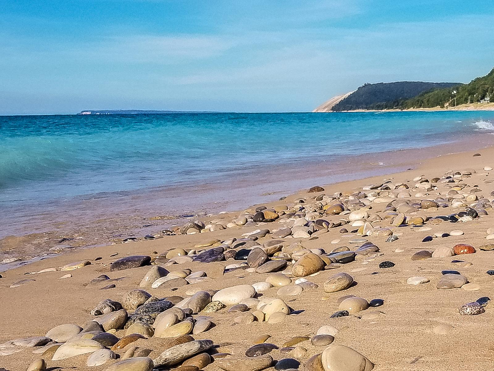
Sleeping Bear Dunes National Lakeshore
National Lakeshore
Miles of sand beach, bluffs that tower 450’ above Lake Michigan, lush forests, clear inland lakes, unique flora and fauna make up the natural world of Sleeping Bear Dunes. High dunes afford spectacula...
Park data from the National Park Service API. Alerts update every 2 hours.
More Details
What kind of drive is this?
Expect a turn-heavy, local drive that prioritizes state highways over high-speed interstate travel. With a 0% highway share, you won't be dealing with the monotony of long, straight stretches typical of major freeways. Instead, the route demands your full attention as you navigate the winding turns of the Benzie and Cadillac Highways. The road conditions change as you shift from the rural stretches near Benzonia toward the more populated areas approaching Ann Arbor. This is a hands-on driving experience where the lack of major highways means you remain in constant contact with the local landscape.
64% highway — fuel and pacing are the main things to plan.
22 navigation steps total — most of the decisions cluster near the start and finish.
Longest single stretch: 61.4 mi on West M-115 Highway.
How Hard Is This Drive?
7/10
This is a straightforward highway drive that stays mostly on West M-115 Highway and US 10. This route has several spots where lane changes, forks, or exits need your full attention. The trickiest moment comes around 93.3 miles in near US 10.
Driving Effort7/10
Demanding - plan breaks and stay ahead of the key maneuvers
Balances navigation complexity with total wheel time.
This is a demanding drive. With 14 significant decision points across 235.9 miles, you will need to stay alert - especially through interchange areas and urban stretches. Consider splitting it into segments if you are not comfortable with fast highway navigation.
Where does it get tricky?
The main spots that need attention: at 93.3 miles (US 10): Exit ramp - move to the correct lane early. Multiple destination signs - pick the right one; at 139.4 miles: Exit ramp - move to the correct lane early. Multiple destination signs - pick the right one; at 187 miles (US 23): Highway fork - watch signs carefully. Lane positioning matters here.
Elevation Profile
Gently rolling terrain
1,409 ft602 ft
Total Climb
1,012 ft
Total Descent
951 ft
Highest Point
1,409 ft
~33.7 mi in
Elevation Range
807 ft
Towns Mentioned on Route Signs
Based on OSRM destination-sign hints, not a full list of every settlement the road passes.
On the drive from Benzonia, MI to Ann Arbor, MI, road signs begin pointing toward Bay City along the way.
Ann Arbor — often abbreviated as AA or A2 — is a picturesque city surrounding the University of Michigan. It has a strong bent toward the arts, and an attractive and pedestrian-friendly downtown. Visitors enjoy the city's wonderful sidewalk cafe dining, unique shops, lots of bookstores, and abundant cultural opportunities.
Ann Arbor is in Michigan 35 miles (56 km) north of the Ohio border and 45 miles (72 km) west of Detroit, near where the furthest exurban fringes give way to country and small towns. In 2019, the city had a population of about 120,000 people, and thousands of visitors come to town for football games and various festivals.
Top landmarks
•Detroit Observatory — astronomical observatory in Ann Arbor, United States of America
•Kelsey Museum of Archaeology — archaeology museum in Newberry Hall
•Ann Arbor Hands-On Museum — museum in Ann Arbor, Michigan, USA
Doable as a same-day drive at 4h 33m. Total distance: 235.9 miles.
Family Friendly
Moderate complexity with 1 natural rest stops along the way.
Solo Traveler
4h 33m drive, comfortable solo distance.
Frequently Asked Questions
The longest stretch is about 61.4 miles on West M-115 Highway. The full list of main roads is in the Roads section above.
Yes — we found about 16 rest areas or service plazas within a short detour of the route (from OpenStreetMap). See the Rest Stops tab under Nearby Places for locations and mile markers. Plan to stretch, use the bathroom, and top off fluids every 2–3 hours on longer drives.
It helps. This route has a higher-than-average number of complex decision points, which get harder in the dark. If the last hour of the trip is on surface roads or mountain grades, aim to arrive at Ann Arbor, MI before sunset when you can. Check the Trip Plan for departure windows that land you in daylight.
Only with planning. This is a long drive for kids — consider splitting it into two days rather than pushing through. Plan at least 1 meaningful breaks. There are 16 rest areas along the route for bathroom stops.
The main spots that need attention: at 93.3 miles (US 10): Exit ramp - move to the correct lane early. Multiple destination signs - pick the right one; at 139.4 miles: Exit ramp - move to the correct lane early. Multiple destination signs - pick the right one; at 187 miles (US 23): Highway fork - watch signs carefully. Lane positioning matters here.
Yes — Sleeping Bear Dunes National Lakeshore. See the National Parks section for detour distances and tips on detours.
Possible but tiring. At 4.6 hours each way, an in-and-out day trip would put you behind the wheel for 9.1 hours — manageable with a long break at Ann Arbor, MI, but most travelers stay overnight.