Connecting Woodland to Yakima is a straightforward 185-mile journey that typically takes about 3 hours and 42 minutes to complete. Because the travel time is relatively manageable, this route is perfectly suited for a single-day trip, allowing you to reach your destination without the need for an overnight stay. You can expect to spend approximately $39 on fuel, making it a budget-friendly option for a quick getaway. The path primarily follows I-5 and US 12, transitioning you from the Pacific Coast region toward the interior. Whether you are heading out for work or leisure, this drive offers a reliable and efficient way to cross the state.
Trip Pace
Same-day drive is realistic
A same-day return is realistic if you keep stops short.
Break Rhythm
1 planned break
A short stop every 2 to 3 hours is enough for this drive.
Midpoint
92.5 miles from Woodland, WA
A natural place for your longest stop of the day
, about 1h 46m into the drive
.
Main Roads
Road
Distance
Duration
US 12
135.6 mi
2h 44m
I 5
46.1 mi
49m
North 1st Street
1.6 mi
3m
Atlantic Avenue
0.7 mi
1m
Lewis River Road
0.2 mi
<1m
Selah Road
<0.1 mi
<1m
Goerig Street
<0.1 mi
<1m
South 1st Street
—
—
Some road-level metrics are being recalculated.
Longest stretch:
US 12
— 135.6 mi, about 2h 44m
Turn-by-Turn Driving Directions
Step-by-step road directions between Woodland, WA and Yakima, WA.
1
Start on Goerig Street
72 ft·2 sec·Goerig Street
2
Keep slight right at fork onto Lewis River Road
0.2 mi·34 sec·Lewis River Road
Use the straight / right lanes.
3
Turn left onto Atlantic Avenue
0.7 mi·1 min·Atlantic Avenue
4
Take the ramp
0.3 mi·36 sec
5
Merge onto I 5
46 mi·49 min·I 5
6
Take the exit
0.3 mi·40 sec
Toward US 12 East: Morton, Yakima
7
Turn right onto US 12
119 mi·2 hr 22 min·US 12
8
Continue on US 12
17 mi·22 min·US 12
9
Take the exit
0.3 mi·34 sec
Toward North 1st Street
10
Turn straight onto Selah Road
298 ft·5 sec·Selah Road
11
Continue on North 1st Street
1.6 mi·3 min·North 1st Street
12
Arrive at destination
South 1st Street
Trip Plan
Planning your departure is simple since the route is short enough to tackle in one go, but incorporating at least one stop is recommended to break up the long stretch on US 12. Aim to fuel up before hitting the highway to manage your $39 travel budget effectively. Because this is a high-speed route, keep a close eye on your speed and traffic flow, especially during peak commuting hours. Since you only have one planned stop, use that time to stretch your legs and refresh before finishing the final leg into Yakima. Flexibility is your biggest advantage here, so feel free to time your departure to avoid the heaviest regional traffic near your starting point.
Morning Departure
An early start around 7-8 AM gets you there with plenty of daylight left.
Evening Departure
A late afternoon start means arriving after dark. Morning is better.
You can normally do this drive in one day.
Plan roughly 1 meaningful break for fuel, food, and rest.
The halfway point lands around 92.5 miles from Woodland, WA, or about 1h 46m into the drive.
The longest continuous stretch on this route runs about 135.6 miles.
This is a comfortable same-day trip.
Departure
Before you leave
Start with fuel, water, and navigation already sorted so the first hour feels easy.
First stop
Around 41 miles or 45m in
Use this first pause for coffee, a restroom break, and a quick traffic check ahead.
Halfway reset
Around 92.5 miles or 1h 46m in
This is the best place for your longest stop, a real meal, and a full fuel check.
Final approach
Final hour starts around 2h 57m
Traffic, exits, and arrival timing usually matter more near Yakima, WA than in the middle of the route.
Before You Leave
+
Open the route before leaving Woodland, WA so your first major turns are already loaded.
+
Leave with enough water and a charging cable within reach, not packed away.
+
Check your fuel range against the first long segment, especially if you are starting outside city service areas.
Day 1
Settle into the route from Woodland, WA
This is one driving day of about 185 miles and 3h 42m.
Your first comfortable stop window is around 41 miles from Woodland, WA.
This route can stay practical as a one-day drive if traffic stays reasonable.
Plan about 1 real break rather than only quick fuel stops.
The longest stretch is on US 12 for about 135.6 miles.
Where to Stop
Rest stops, refuel points, and overnight suggestions along this route.
Place data sourced from public business listings. Hours and availability may vary.
Heads-up: tricky spots
5 of 6
5 decision points cluster between mile 0 and 183.1 — GPS handles the exact turns, but know they're coming. Your lane choice matters more than the turn itself.
7
0 mi into trip|~0m in|Lewis River Road
Keep slight right at fork onto Lewis River Road
Highway fork - watch signs carefully. Lane positioning matters here
Use the straight / right lanes.
4
0.2 mi into trip|~0m in|Atlantic Avenue
Turn left onto Atlantic Avenue
Navigation decision point
3
1.2 mi into trip|~2m in|I 5
Merge onto I 5
Merge point - match speed before joining
5
47.3 mi into trip|~52m in
Take the exit toward US 12 East: Morton, Yakima
Exit ramp - move to the correct lane early. Multiple destination signs - pick the right one
Toward US 12 East: Morton, Yakima
4
183.1 mi into trip|~3h 37m in
Take the exit toward North 1st Street
Exit ramp - move to the correct lane early
Toward North 1st Street
Fuel & Cost
Regular Gas
$38.72 one way
$77.44 round trip
$5.32/gal25.4 MPG avg65 kg CO2
Fuel Type
$/gal
One Way
Round Trip
midgrade
$5.58
$40.61
$81.21
premium
$5.77
$42.01
$84.02
diesel
$5.61
$40.85
$81.69
No toll roads detected on this route.
Estimated Trip Cost (one way, 1 person)
Fuel
$39
Meals
$25–$50
Total
$64–$89
Rough estimate based on US averages. Hotel $80–$140/night, meals $25–$50/day.
Estimated CO2 emission: 64.7 kg one way.
Prices: EIA weekly data, 2026-04-13.
Driving Electric?
About $19 in charging
· 0 stops
· 66% less CO2
Vehicle Type
kWh
Stops
DC Fast
Home Charge
Average EV
55.5
0
$19.42
$8.88
Efficient EV
46.3
0
$16.19
$7.40
EV Truck/SUV
74
0
$25.90
$11.84
Gas CO2
65 kg
EV CO2
22 kg (66% less)
This trip is well within single-charge range for most EVs. No charging stops needed if you start fully charged.
DC fast charging avg $0.35/kWh. Home charging avg $0.16/kWh. US grid CO2: 0.39 kg/kWh.
Travel Intel
Current conditions at both ends of the drive.
Forecast as of Apr 15, 2026
Origin
Woodland, WA
Morning
in Woodland on Sunday
Local time
7:40 AM
PDT
Current temp
47°F
Unavailable
Live forecast
Destination
Yakima, WA
Morning
in Yakima on Sunday
Local time
7:40 AM
PDT
Current temp
46°F
Unavailable
Live forecast
Seasonal Notes
Summer travel usually means heavier construction, hotter rest stops, and busier weekend traffic around major cities.
Winter travel shortens daylight, so a route that looks manageable on paper can feel much longer after dark.
Holiday weekends tend to make both departure and arrival windows slower than the raw route time suggests.
Time zone
Same local time
Origin and destination are on the same clock, so arrival timing is easier to judge at a glance.
Temperature spread
1 degrees cooler at arrival
A meaningful temperature swing is a good cue to rethink layers, water, and how soon you want to arrive.
Road read
3h 42m on the road
Use the two city cards together: check the sky where you start, then compare it with the local time and temperature at arrival.
Weather data from the National Weather Service. Conditions may change; check closer to your travel date.
National Parks Near This Route
Worth a detour if your schedule allows.
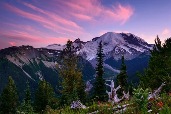
Mount Rainier National Park
National Park
Ascending to 14,410 feet above sea level, Mount Rainier stands as an icon in the Washington landscape. An active volcano, Mount Rainier is the most glaciated peak in the contiguous U.S.A., spawning fi...
14 mi from route
~34 min detour
$30
near mile 121.2
Park Closure: Regular nightly closures of the Longmire gate have ended for the season.
Park Closure: SR 165 Carbon River/Fairfax Bridge is closed: no access to Carbon River or Mowich Lake.
Park data from the National Park Service API. Alerts update every 2 hours.
More Details
What kind of drive is this?
Expect a highway-focused experience, as 98% of this trip consists of high-speed transit. You will spend the bulk of your time on US 12, which accounts for the longest uninterrupted stretch of 135.6 miles. The road maintains a consistent pace, shifting from the busy corridors near Woodland to the more open stretches that define the remainder of the drive. While the route is largely defined by its efficiency, the transition between these major arteries keeps the experience steady and predictable. It is an ideal path for drivers who prefer a focused, interstate-heavy drive over navigating winding local backroads.
98% highway — fuel and pacing are the main things to plan.
12 navigation steps total — most of the decisions cluster near the start and finish.
Longest single stretch: 135.6 mi on US 12.
How Hard Is This Drive?
2/10
This is a straightforward highway drive that stays mostly on US 12 and I 5. Navigation is very simple - set it and forget it for most of the drive. The trickiest moment comes early in the drive near Lewis River Road.
Driving Effort2/10
Very easy - short and simple to drive
Balances navigation complexity with total wheel time.
The drive from Woodland, WA to Yakima, WA is easy. At 3h 42m with 98% highway, most drivers will find it relaxed and low-stress.
Where does it get tricky?
The main spots that need attention: near the start (Lewis River Road): Highway fork - watch signs carefully. Lane positioning matters here; at 0.2 miles (Atlantic Avenue): Navigation decision point; at 1.2 miles (I 5): Merge point - match speed before joining.
Elevation Profile
Hilly terrain with moderate elevation changes
4,263 ft29 ft
Total Climb
4,546 ft
Total Descent
3,510 ft
Highest Point
4,263 ft
~131 mi in
Elevation Range
4,234 ft
Notable High Points
4,263 ft at ~131 miles+988 ft prominence
Who Is This Route For?
Weekend Trip
Doable as a same-day drive at 3h 42m. Total distance: 185 miles.
Family Friendly
Moderate complexity with 1 natural rest stops along the way.
The longest stretch is about 135.6 miles on US 12. The full list of main roads is in the Roads section above.
We did not find dedicated rest areas on this route. For a drive this long, plan bathroom and stretch breaks around gas stations, fast-food stops, or small-town downtowns — check the Nearby Places section for options.
Yes, with realistic expectations. Build in a stop roughly every 2 hours, have snacks and activities ready, and check the Nearby Places tabs for kid-friendly stops along the way.
The main spots that need attention: near the start (Lewis River Road): Highway fork - watch signs carefully. Lane positioning matters here; at 0.2 miles (Atlantic Avenue): Navigation decision point; at 1.2 miles (I 5): Merge point - match speed before joining.
Yes — Mount Rainier National Park. See the National Parks section for detour distances and tips on detours.
Possible but tiring. At 3.7 hours each way, an in-and-out day trip would put you behind the wheel for 7.4 hours — manageable with a long break at Yakima, WA, but most travelers stay overnight.