Traveling from Tyler to Saint Paul spans 184.4 miles across the Minnesota landscape, making for a straightforward trek that typically takes about 3 hours and 59 minutes. Because this is a relatively short distance, you can easily complete the journey in a single day without needing an overnight stay. Expect to spend roughly $26 on fuel for the trip, depending on your vehicle's efficiency. You will primarily utilize US 212 and State Highway 19, which serve as the backbone of your transit through the Midwest. It is an ideal route for those looking to get from the southwestern part of the state to the capital efficiently. Whether you are heading out for business or a visit, the lack of required stops makes this a manageable and direct drive.
Trip Pace
Same-day drive is realistic
A same-day return is realistic if you keep stops short.
Break Rhythm
1 planned break
A short stop every 2 to 3 hours is enough for this drive.
Midpoint
92.2 miles from Tyler, MN
A natural place for your longest stop of the day
, about 2h 1m into the drive
.
Main Roads
Road
Distance
Duration
US 212
50.3 mi
1h
State Highway 19
34.4 mi
43m
MN 19
31.3 mi
42m
State Highway 23
22.3 mi
27m
State Highway 15
12.6 mi
15m
MN 5
10.7 mi
13m
West Bridge Street
7.2 mi
10m
Shepard Road
5.1 mi
8m
Longest stretch:
US 212
— 50.3 mi, about 1h
Turn-by-Turn Driving Directions
Step-by-step road directions between Tyler, MN and Saint Paul, MN.
1
Start on CR 7
0.2 mi·24 sec·Strong Street
2
Continue on CR 7
0.4 mi·1 min·South Tyler Street
3
Turn left onto US 14
4.4 mi·5 min·US Highway 14
4
Continue on US 14
0.5 mi·40 sec·Garfield Street
5
Continue on US 14
0.2 mi·18 sec·US Highway 14
6
Take the exit onto US 14/MN 23
0.2 mi·27 sec·US 14/MN 23
7
Turn right onto MN 23
22 mi·27 min·State Highway 23
8
Turn right onto MN 19; MN 68
0.5 mi·53 sec·East College Drive
9
Continue on MN 19; MN 68
13 mi·16 min·State Highway 19
10
Continue on MN 19
21 mi·26 min·State Highway 19
11
Continue on MN 19; MN 67
0.6 mi·1 min·West Bridge Street
12
Keep slight left at fork onto MN 19
6.6 mi·9 min·West Bridge Street
Use the straight / right lanes.
13
Turn slight right onto MN 19
31 mi·42 min·MN 19
Toward MN 19: Morton, Fairfax
14
Turn left onto MN 15
13 mi·15 min·State Highway 15
15
Turn right onto US 212
13 mi·15 min·US 212
16
Enter roundabout onto US 212
156 ft·2 sec·US 212
17
Continue on US 212
10 mi·11 min·US 212
18
Keep slight right at fork onto US 212
27 mi·32 min·US 212
Use the straight lane.
19
Take the exit onto MN 5
0.2 mi·17 sec·MN 5
Toward I 494 East, MN 5 EastUse the straight / slight right lanes.
20
Keep slight left at fork onto MN 5
10 mi·13 min·MN 5
Toward I 494 East, MN 5 EastUse the straight / slight right lanes.
21
Take the exit onto MN 5
2.2 mi·2 min·John A. Johnson Memorial Highway
Exit 1AToward MN 5: Terminal 1Use the straight / slight right lanes.
22
Continue on MN 5
1.2 mi·1 min·Fort Road
Use the straight / slight right lanes.
23
Take the exit
197 ft·4 sec
Toward Edgcumbe Road, Shepard Road, River BoulevardUse the straight / slight right lanes.
24
Keep slight right at fork
223 ft·5 sec
Toward Shepard Road, River BoulevardUse the slight left / slight right lanes.
25
Turn right onto Gannon Road
285 ft·7 sec·Gannon Road
26
Turn left onto Shepard Road
5.1 mi·8 min·Shepard Road
Use the left / straight lanes.
27
Turn left onto Eagle Parkway
0.2 mi·44 sec·Eagle Parkway
Use the straight lane.
28
Turn right onto Exchange Street South
0.2 mi·34 sec·Exchange Street South
Use the right lane.
29
Turn straight onto Kellogg Boulevard West
0.2 mi·52 sec·Kellogg Boulevard West
30
Turn left onto Wabasha Street North
214 ft·9 sec·Wabasha Street North
Use the left lane.
31
Arrive at destination
Wabasha Street North
Trip Plan
To make the most of your 184.4-mile trip, aim to depart in the morning to avoid any potential traffic as you approach the Saint Paul area. Since the route only requires a single stop to keep you refreshed, plan to stretch your legs at the midway point to break up the four-hour duration. Keep an eye on your fuel gauge throughout the drive, as the $26 estimate assumes steady highway speeds. Because the route is short, you have plenty of flexibility to adjust your departure time based on your personal schedule. A great strategy for this specific route is to utilize that one planned stop for a full vehicle check, ensuring you arrive at your destination without any mechanical worries.
Morning Departure
An early start around 7-8 AM gets you there with plenty of daylight left.
Evening Departure
A late afternoon start means arriving after dark. Morning is better.
You can normally do this drive in one day.
Plan roughly 1 meaningful break for fuel, food, and rest.
The halfway point lands around 92.2 miles from Tyler, MN, or about 2h 1m into the drive.
The longest continuous stretch on this route runs about 50.3 miles.
This is a comfortable same-day trip.
Departure
Before you leave
Start with fuel, water, and navigation already sorted so the first hour feels easy.
First stop
Around 41 miles or 53m in
Use this first pause for coffee, a restroom break, and a quick traffic check ahead.
Halfway reset
Around 92.2 miles or 2h 1m in
This is the best place for your longest stop, a real meal, and a full fuel check.
Final approach
Final hour starts around 3h 14m
Traffic, exits, and arrival timing usually matter more near Saint Paul, MN than in the middle of the route.
Before You Leave
+
Open the route before leaving Tyler, MN so your first major turns are already loaded.
+
Leave with enough water and a charging cable within reach, not packed away.
+
Check your fuel range against the first long segment, especially if you are starting outside city service areas.
Day 1
Settle into the route from Tyler, MN
This is one driving day of about 184.4 miles and 3h 59m.
Your first comfortable stop window is around 41 miles from Tyler, MN.
This route can stay practical as a one-day drive if traffic stays reasonable.
Plan about 1 real break rather than only quick fuel stops.
The longest stretch is on US 212 for about 50.3 miles.
Where to Stop
Rest stops, refuel points, and overnight suggestions along this route.
Place data sourced from public business listings. Hours and availability may vary.
Heads-up: tricky spots
5 of 18
5 decision points cluster between mile 164.4 and 178.6 — GPS handles the exact turns, but know they're coming. Your lane choice matters more than the turn itself.
7
164.4 mi into trip|~3h 30m in|MN 5
Take the exit onto MN 5 toward I 494 East, MN 5 East
Exit ramp - move to the correct lane early. Lane positioning matters here. Multiple destination signs - pick the right one
Use the straight / slight right lanes.
Toward I 494 East, MN 5 East
8
164.7 mi into trip|~3h 30m in|MN 5
Keep slight left at fork onto MN 5 toward I 494 East, MN 5 East
Highway fork - watch signs carefully. Lane positioning matters here. Multiple destination signs - pick the right one
Use the straight / slight right lanes.
Toward I 494 East, MN 5 East
7
175.2 mi into trip|~3h 43m in|MN 5 / John A. Johnson Memorial Highway
Take the exit onto MN 5 / John A. Johnson Memorial Highway toward MN 5: Terminal 1
Exit ramp - move to the correct lane early. Lane positioning matters here
Use the straight / slight right lanes.
Exit 1A
Toward MN 5: Terminal 1
7
178.5 mi into trip|~3h 47m in
Take the exit toward Edgcumbe Road, Shepard Road, River Boulevard
Exit ramp - move to the correct lane early. Lane positioning matters here. Multiple destination signs - pick the right one
Use the straight / slight right lanes.
Toward Edgcumbe Road, Shepard Road, River Boule...
9
178.6 mi into trip|~3h 48m in
Keep slight right at fork toward Shepard Road, River Boulevard
Highway fork - watch signs carefully. Lane positioning matters here. Multiple destination signs - pick the right one
Use the slight left / slight right lanes.
Toward Shepard Road, River Boulevard
Fuel & Cost
Regular Gas
$27.44 one way
$54.88 round trip
$3.78/gal25.4 MPG avg65 kg CO2
Fuel Type
$/gal
One Way
Round Trip
midgrade
$4.07
$29.57
$59.14
premium
$4.53
$32.90
$65.80
diesel
$5.61
$40.71
$81.43
No toll roads detected on this route.
Estimated Trip Cost (one way, 1 person)
Fuel
$27
Meals
$25–$50
Total
$52–$77
Rough estimate based on US averages. Hotel $80–$140/night, meals $25–$50/day.
Estimated CO2 emission: 64.5 kg one way.
Prices: EIA weekly data, 2026-04-13.
Driving Electric?
About $19 in charging
· 0 stops
· 66% less CO2
Vehicle Type
kWh
Stops
DC Fast
Home Charge
Average EV
55.3
0
$19.36
$8.85
Efficient EV
46.1
0
$16.13
$7.38
EV Truck/SUV
73.8
0
$25.82
$11.80
Gas CO2
65 kg
EV CO2
22 kg (66% less)
This trip is well within single-charge range for most EVs. No charging stops needed if you start fully charged.
DC fast charging avg $0.35/kWh. Home charging avg $0.16/kWh. US grid CO2: 0.39 kg/kWh.
Travel Intel
Current conditions at both ends of the drive.
Forecast as of Apr 15, 2026
Origin
Tyler, MN
Late night
in Tyler on Sunday
Local time
3:02 AM
CDT
Current temp
71°F
Unavailable
Live forecast
Destination
Saint Paul, MN
Late night
in Saint Paul on Sunday
Local time
3:02 AM
CDT
Current temp
67°F
Unavailable
Live forecast
Seasonal Notes
Summer travel usually means heavier construction, hotter rest stops, and busier weekend traffic around major cities.
Winter travel shortens daylight, so a route that looks manageable on paper can feel much longer after dark.
Holiday weekends tend to make both departure and arrival windows slower than the raw route time suggests.
Time zone
Same local time
Origin and destination are on the same clock, so arrival timing is easier to judge at a glance.
Temperature spread
4 degrees cooler at arrival
A meaningful temperature swing is a good cue to rethink layers, water, and how soon you want to arrive.
Road read
3h 59m on the road
Use the two city cards together: check the sky where you start, then compare it with the local time and temperature at arrival.
Weather data from the National Weather Service. Conditions may change; check closer to your travel date.
National Parks Near This Route
Worth a detour if your schedule allows.
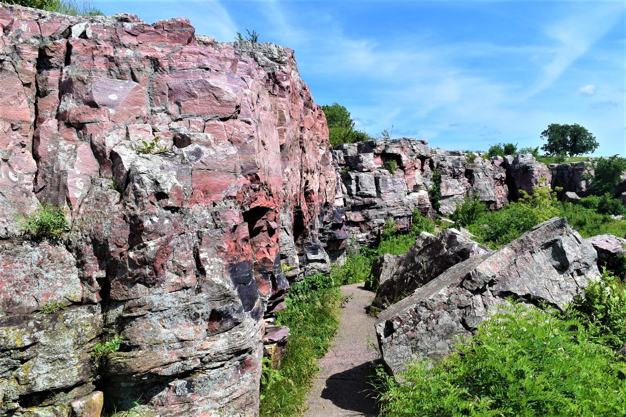
Pipestone National Monument
National Monument
For over 3,000 years, Indigenous people have quarried the red stone at this site to make pipes used in prayer and ceremony - a tradition that continues to this day and makes this site sacred to many p...
Park data from the National Park Service API. Alerts update every 2 hours.
More Details
What kind of drive is this?
This journey is a highway-focused drive, with 90% of your travel spent on major routes. You will find yourself navigating long stretches of open road, with your longest uninterrupted segment covering 50.3 miles on US 212. Expect a consistent pace as you transition between these primary roads, which offer a predictable experience compared to winding backroads. The character of the drive remains steady, moving you efficiently through the region while minimizing the need for frequent turns. Being behind the wheel here is about steady cruising and maintaining momentum as you head toward Saint Paul.
90% highway — fuel and pacing are the main things to plan.
31 navigation steps total — most of the decisions cluster near the start and finish.
Longest single stretch: 50.3 mi on US 212.
How Hard Is This Drive?
9/10
This is a straightforward highway drive that stays mostly on US 212 and State Highway 19. This route has several spots where lane changes, forks, or exits need your full attention. The trickiest moment comes around 164.4 miles in near MN 5.
Driving Effort9/10
High effort - long or complex enough to need steady focus all day
Balances navigation complexity with total wheel time.
This is a demanding drive. With 18 significant decision points across 184.4 miles, you will need to stay alert - especially through interchange areas and urban stretches. Consider splitting it into segments if you are not comfortable with fast highway navigation.
Where does it get tricky?
The main spots that need attention: at 164.4 miles (MN 5): Exit ramp - move to the correct lane early. Lane positioning matters here. Multiple destination signs - pick the right one; at 164.7 miles (MN 5): Highway fork - watch signs carefully. Lane positioning matters here. Multiple destination signs - pick the right one; at 175.2 miles (MN 5 / John A. Johnson Memorial Highway): Exit ramp - move to the correct lane early. Lane positioning matters here.
Towns Mentioned on Route Signs
Based on OSRM destination-sign hints, not a full list of every settlement the road passes.
On the drive from Tyler, MN to Saint Paul, MN, road signs begin pointing toward Fairfax along the way.
Fairfax
70.2 mi in|~1h 31m|via MN 19
Who Is This Route For?
Weekend Trip
Doable as a same-day drive at 3h 59m. Total distance: 184.4 miles.
Family Friendly
Moderate complexity with 1 natural rest stops along the way.
Solo Traveler
3h 59m drive, comfortable solo distance.
First-Time Driver
Mostly highway driving (90%). Some complex stretches to watch for.
Frequently Asked Questions
The longest stretch is about 50.3 miles on US 212. The full list of main roads is in the Roads section above.
We did not find dedicated rest areas on this route. For a drive this long, plan bathroom and stretch breaks around gas stations, fast-food stops, or small-town downtowns — check the Nearby Places section for options.
It helps. This route has a higher-than-average number of complex decision points, which get harder in the dark. If the last hour of the trip is on surface roads or mountain grades, aim to arrive at Saint Paul, MN before sunset when you can. Check the Trip Plan for departure windows that land you in daylight.
Only with planning. This is a long drive for kids — consider splitting it into two days rather than pushing through. Plan at least 1 meaningful breaks. Dedicated rest areas are limited, so plan gas or food stops as your bathroom breaks.
The main spots that need attention: at 164.4 miles (MN 5): Exit ramp - move to the correct lane early. Lane positioning matters here. Multiple destination signs - pick the right one; at 164.7 miles (MN 5): Highway fork - watch signs carefully. Lane positioning matters here. Multiple destination signs - pick the right one; at 175.2 miles (MN 5 / John A. Johnson Memorial Highway): Exit ramp - move to the correct lane early. Lane positioning matters here.
Yes — Pipestone National Monument. See the National Parks section for detour distances and tips on detours.
Possible but tiring. At 4.0 hours each way, an in-and-out day trip would put you behind the wheel for 8.0 hours — manageable with a long break at Saint Paul, MN, but most travelers stay overnight.