This 97.4-mile drive from The Pinery to Pueblo, Colorado, is a straightforward 1 hour and 51 minutes, making it an easy day trip. You'll be spending about half your time on major highways, with a significant stretch on I-25. The estimated fuel cost for this journey is around $15, which is quite budget-friendly. Given the relatively short duration and minimal stops suggested, this route offers a lot of flexibility for when you want to depart and how you want to pace your travel. It's a practical option for moving between two points within the Mountain West region.
Trip Pace
Same-day drive is realistic
A same-day return is realistic if you keep stops short.
Midpoint
48.7 miles from The Pinery, CO
A natural place for your longest stop of the day
, about 59m into the drive
.
Main Roads
Road
Distance
Duration
I 25
36 mi
37m
Ronald Reagan Highway
22.9 mi
23m
John F. Kennedy Memorial Highway
12.9 mi
12m
Monument Valley Freeway
8.8 mi
10m
North Freeway
5.2 mi
6m
Crowfoot Valley Road
4.5 mi
6m
Founders Parkway
1.6 mi
2m
Scott Avenue
1.3 mi
2m
Longest stretch:
I 25
— 36 mi, about 37m
Turn-by-Turn Driving Directions
Step-by-step road directions between The Pinery, CO and Pueblo, CO.
1
Start on this road
61 ft·6 sec·this road
2
Turn right onto Mountain View Drive
412 ft·20 sec·Mountain View Drive
3
Turn right onto Lakeview Drive
1.3 mi·3 min·Lakeview Drive
4
Turn left onto North Pinery Parkway
0.2 mi·29 sec·North Pinery Parkway
5
Turn left onto CO 83
0.5 mi·52 sec·North State Highway 83
6
Turn right onto Scott Avenue
1.3 mi·2 min·Scott Avenue
7
At end of road, turn right onto Bayou Gulch Road
0.7 mi·1 min·Bayou Gulch Road
8
Turn left onto North Pinery Parkway
0.5 mi·1 min·North Pinery Parkway
9
At end of road, turn left onto Crowfoot Valley Road
4.5 mi·6 min·Crowfoot Valley Road
10
Turn right onto CO 86
1.6 mi·2 min·Founders Parkway
Use the left lane.
11
Take the exit
0.3 mi·43 sec
Toward I 25 South: Colorado Springs
12
Merge onto I 25
36 mi·37 min·I 25
Use the straight / slight right lanes.
13
Continue on I 25
8.8 mi·10 min·Monument Valley Freeway
Use the straight / slight right lanes.
14
Continue on I 25; US 24
0.2 mi·12 sec·Ronald Reagan Highway
15
Keep slight left at fork onto I 25
23 mi·23 min·Ronald Reagan Highway
Use the straight / slight right lanes.
16
Continue on I 25
13 mi·12 min·John F. Kennedy Memorial Highway
Use the straight / slight right lanes.
17
Continue on I 25
2.6 mi·2 min·North Freeway
Use the straight / slight right lanes.
18
Take the exit
0.4 mi·32 sec
Exit 100BToward 29th Street
19
Merge onto I 25; US 50
1.0 mi·1 min·North Freeway
20
Take the exit
0.1 mi·12 sec
Exit 99BToward 13th StreetUse the slight right lane.
21
Continue on this road
0.2 mi·18 sec·this road
22
Merge onto I 25; US 50 Bus
1.6 mi·2 min·North Freeway
Use the straight lane.
23
Take the exit
107 ft·2 sec
Toward Abriendo Avenue
24
Arrive at destination
Toward Abriendo Avenue
Trip Plan
For this 1 hour and 51 minute trip, you have the advantage of flexibility. Consider an early morning departure to avoid any potential traffic, though with only 97.4 miles, it's less of a concern. The estimated fuel cost of $15 means you won't need to worry too much about refueling stops, but it's always wise to start with a full tank. Keep an eye on your fuel gauge, especially during the 36-mile stretch on I-25, as services can sometimes be spaced out on interstates. With no planned stops, you can easily adjust your schedule on the fly.
Morning Departure
Leave by 9 AM and you'll arrive before lunch.
Evening Departure
Even a 4 PM departure gets you there before dark in summer.
You can normally do this drive in one day.
You may only need one short stretch break if traffic stays light.
The halfway point lands around 48.7 miles from The Pinery, CO, or about 59m into the drive.
The longest continuous stretch on this route runs about 36 miles.
This is a comfortable same-day trip.
Departure
Before you leave
Start with fuel, water, and navigation already sorted so the first hour feels easy.
First stop
Around 21 miles or 30m in
Use this first pause for coffee, a restroom break, and a quick traffic check ahead.
Halfway reset
Around 48.7 miles or 59m in
This is the best place for your longest stop, a real meal, and a full fuel check.
Final approach
Final hour starts around 1h 32m
Traffic, exits, and arrival timing usually matter more near Pueblo, CO than in the middle of the route.
Before You Leave
+
Open the route before leaving The Pinery, CO so your first major turns are already loaded.
Day 1
Settle into the route from The Pinery, CO
This is one driving day of about 97.4 miles and 1h 51m.
Your first comfortable stop window is around 21 miles from The Pinery, CO.
This route can stay practical as a one-day drive if traffic stays reasonable.
The longest stretch is on I 25 for about 36 miles.
Where to Stop
Rest stops, refuel points, and overnight suggestions along this route.
Place data sourced from public business listings. Hours and availability may vary.
Heads-up: tricky spots
5 of 16
5 decision points cluster between mile 4.5 and 95.5 — GPS handles the exact turns, but know they're coming. Your lane choice matters more than the turn itself.
5
4.5 mi into trip|~10m in|Crowfoot Valley Road
At end of road, turn left onto Crowfoot Valley Road
Navigation decision point
5
10.9 mi into trip|~20m in|I 25
Merge onto I 25
Merge point - match speed before joining. Lane positioning matters here
Use the straight / slight right lanes.
6
55.8 mi into trip|~1h 7m in|I 25 / Ronald Reagan Highway
Keep slight left at fork onto I 25 / Ronald Reagan Highway
Highway fork - watch signs carefully. Lane positioning matters here
Use the straight / slight right lanes.
5
94 mi into trip|~1h 46m in
Take the exit toward 29th Street
Exit ramp - move to the correct lane early
Exit 100B
Toward 29th Street
7
95.5 mi into trip|~1h 48m in
Take the exit toward 13th Street
Exit ramp - move to the correct lane early. Lane positioning matters here
Use the slight right lane.
Exit 99B
Toward 13th Street
Fuel & Cost
Regular Gas
$14.68 one way
$29.35 round trip
$3.83/gal25.4 MPG avg34 kg CO2
Fuel Type
$/gal
One Way
Round Trip
midgrade
$4.05
$15.54
$31.08
premium
$4.39
$16.85
$33.70
diesel
$5.61
$21.50
$43.01
No toll roads detected on this route.
Estimated Trip Cost (one way, 1 person)
Fuel
$15
Meals
$25–$50
Total
$40–$65
Rough estimate based on US averages. Hotel $80–$140/night, meals $25–$50/day.
Estimated CO2 emission: 34.1 kg one way.
Prices: EIA weekly data, 2026-04-13.
Driving Electric?
About $10 in charging
· 0 stops
· 68% less CO2
Vehicle Type
kWh
Stops
DC Fast
Home Charge
Average EV
29.2
0
$10.23
$4.68
Efficient EV
24.4
0
$8.52
$3.90
EV Truck/SUV
39
0
$13.64
$6.23
Gas CO2
34 kg
EV CO2
11 kg (68% less)
This trip is well within single-charge range for most EVs. No charging stops needed if you start fully charged.
DC fast charging avg $0.35/kWh. Home charging avg $0.16/kWh. US grid CO2: 0.39 kg/kWh.
Travel Intel
Current conditions at both ends of the drive.
Forecast as of Apr 16, 2026
Origin
The Pinery, CO
Afternoon
in The Pinery on Sunday
Local time
2:22 PM
MDT
Current temp
73°F
Mostly Sunny
SW 10 to 20 mph3% chanceLive forecast
Red Flag Warning
Red Flag Warning issued April 16 at 2:53AM MDT until April 16 at 8:00PM MDT by NWS Goodland KS
Freeze Watch
Freeze Watch issued April 16 at 2:37AM MDT until April 18 at 8:00AM MDT by NWS Denver CO
Destination
Pueblo, CO
Afternoon
in Pueblo on Sunday
Local time
2:22 PM
MDT
Current temp
81°F
Unavailable
Live forecast
Seasonal Notes
Summer travel usually means heavier construction, hotter rest stops, and busier weekend traffic around major cities.
Winter travel shortens daylight, so a route that looks manageable on paper can feel much longer after dark.
Holiday weekends tend to make both departure and arrival windows slower than the raw route time suggests.
Time zone
Same local time
Origin and destination are on the same clock, so arrival timing is easier to judge at a glance.
Temperature spread
8 degrees warmer at arrival
A meaningful temperature swing is a good cue to rethink layers, water, and how soon you want to arrive.
Road read
1h 51m on the road
The weather snapshot is not static. If you are leaving later, give both cities one more quick forecast check before departure.
Weather data from the National Weather Service. Conditions may change; check closer to your travel date.
National Parks Near This Route
Worth a detour if your schedule allows.
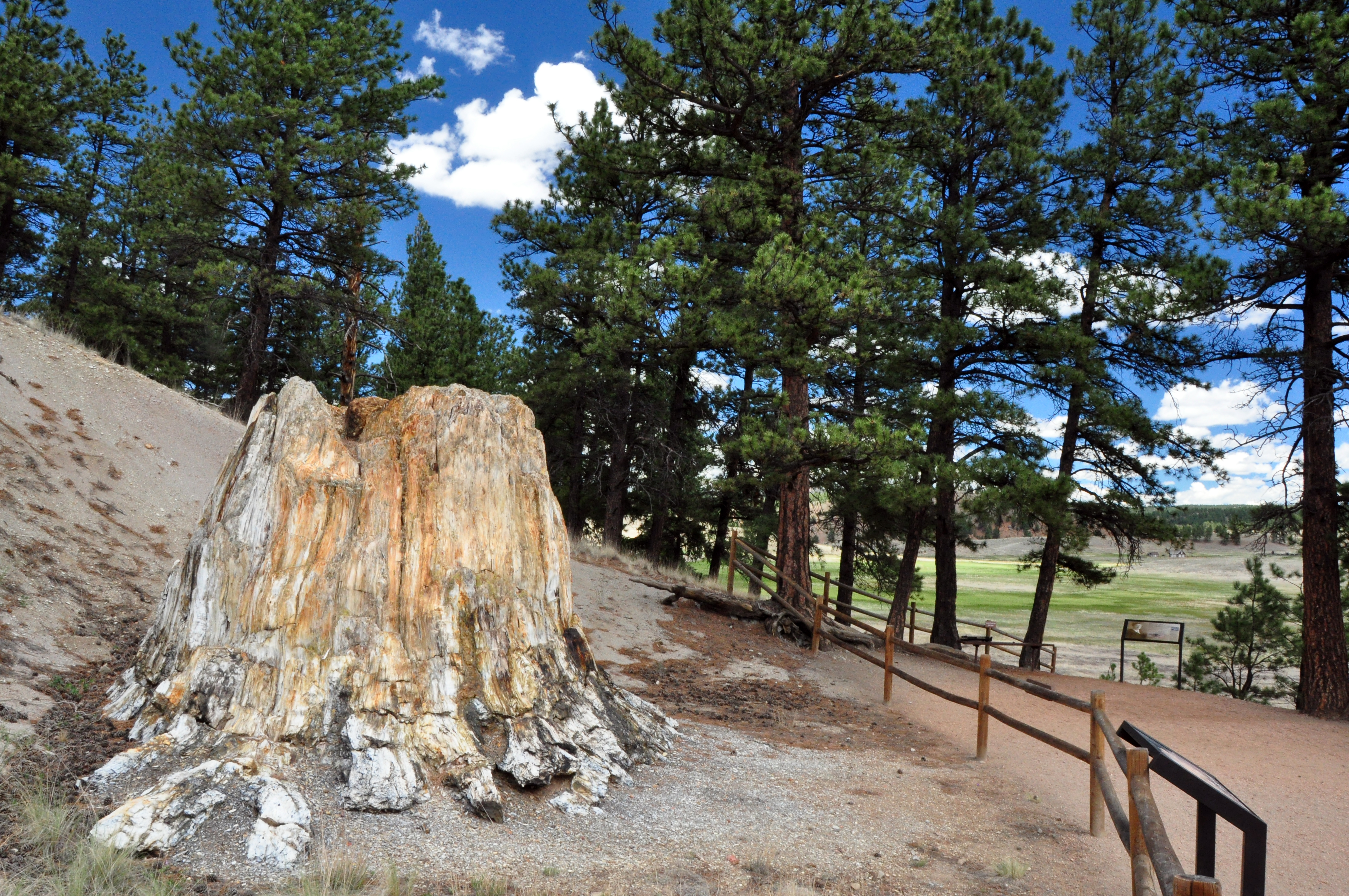
Florissant Fossil Beds National Monument
National Monument
Beneath a grassy mountain valley in central Colorado lies one of the richest and most diverse fossil deposits in the world. Petrified redwood stumps up to 14 feet wide and thousands of detailed fossil...
24 mi from route
~60 min detour
$10
near mile 50.4
Park data from the National Park Service API. Alerts update every 2 hours.
More Details
What kind of drive is this?
Your drive will be a mixed bag, with 54% of it on major highways like I-25 and Ronald Reagan Highway. Expect a comfortable pace for the majority of your trip, including a 36-mile stretch on I-25 where you can maintain steady momentum. While not exclusively a highway grind, the character leans towards efficient travel. You'll experience the typical conditions of major interstates, interspersed with segments on other well-maintained roads as you make your way south. The drive progresses smoothly, offering a consistent driving experience for most of its duration.
54% highway, the rest on surface roads — varied driving throughout.
24 navigation steps total — most of the decisions cluster near the start and finish.
Longest single stretch: 36 mi on I 25.
How Hard Is This Drive?
8/10
This route mixes highway mileage with some local-road sections near the start or finish. This route has several spots where lane changes, forks, or exits need your full attention. The trickiest moment comes around 4.5 miles in near Crowfoot Valley Road.
Driving Effort8/10
Demanding - plan breaks and stay ahead of the key maneuvers
Balances navigation complexity with total wheel time.
This drive requires moderate attention. Across 97.4 miles you will encounter 16 spots where lane choice or exit timing matters. Not difficult for experienced highway drivers, but worth previewing the tricky sections before you go.
Where does it get tricky?
The main spots that need attention: at 4.5 miles (Crowfoot Valley Road): Navigation decision point; at 10.9 miles (I 25): Merge point - match speed before joining. Lane positioning matters here; at 55.8 miles (I 25 / Ronald Reagan Highway): Highway fork - watch signs carefully. Lane positioning matters here.
Pueblo, also known as the Steel City or Home of the Heroes, is a city of about 112,000 people in the Eastern Plains of Colorado. It is on the confluence of the Arkansas River and Fountain Creek.
Doable as a same-day drive at 1h 51m. Total distance: 97.4 miles.
Family Friendly
Moderate complexity with 0 natural rest stops along the way.
Solo Traveler
1h 51m drive, comfortable solo distance.
First-Time Driver
Mostly highway driving (54%). Some complex stretches to watch for.
Scenic Drive
Mixed highway & surface route profile with national parks nearby.
Frequently Asked Questions
The longest stretch is about 36 miles on I 25. The full list of main roads is in the Roads section above.
It helps. This route has a higher-than-average number of complex decision points, which get harder in the dark. If the last hour of the trip is on surface roads or mountain grades, aim to arrive at Pueblo, CO before sunset when you can. Check the Trip Plan for departure windows that land you in daylight.
Yes. At under 2 hours behind the wheel, this works well for families — plan one quick stop if you have younger kids.
The main spots that need attention: at 4.5 miles (Crowfoot Valley Road): Navigation decision point; at 10.9 miles (I 25): Merge point - match speed before joining. Lane positioning matters here; at 55.8 miles (I 25 / Ronald Reagan Highway): Highway fork - watch signs carefully. Lane positioning matters here.
Yes — Florissant Fossil Beds National Monument. See the National Parks section for detour distances and tips on detours.
Yes. A round trip is manageable in a single day if you plan a break at Pueblo, CO before heading back.