St. Petersburg, FL to Isle of Normandy, FL is 262.3 miles and takes about 4h 58m via I 75 and Florida's Turnpike, with a fuel budget near $42 and enough daylight to finish in a day. This trip primarily sticks to major highways across Florida, making it a straightforward, efficient journey. You'll spend most of your time on interstate roads, so expect a consistent pace. With a recommended one-day drive, it's a good option if you're looking to cover ground without a lot of complex navigation. Consider this route for its directness and ease of travel between these two Florida points.
Trip Pace
Same-day drive is realistic
A same-day return is possible, but it will make for a full day on the road.
Break Rhythm
1 planned break
Plan on a short reset every 3 to 4 hours to stay fresh behind the wheel.
Midpoint
131.2 miles from St. Petersburg, FL
A natural place for your longest stop of the day
, about 2h 25m into the drive
.
Main Roads
Road
Distance
Duration
I 75
209.3 mi
3h 44m
Sunshine Skyway Bridge
13.4 mi
15m
Florida's Turnpike
10.4 mi
12m
Port Everglades Expressway
9 mi
10m
I 275
6 mi
8m
I 95
4.5 mi
5m
John F. Kennedy Causeway
1.9 mi
4m
Northeast 79th Street
1.5 mi
3m
Longest stretch:
I 75
— 209.3 mi, about 3h 44m
Traffic on I-75
Hour-of-day weekday pattern from 92 FHWA count stations on your route.
Peak
4 PM
~2,826 veh/hr typical
· worst 3,424
Quietest
2 AM
~185 veh/hr
Peak-to-quiet ratio
15.3×
busier at peak than in the quiet hours
12a6anoon6p11p
Averaged across 52 weeks of 2023 FHWA Travel Monitoring Analysis System data. Weekday hours only (Mon–Fri).
Turn-by-Turn Driving Directions
Step-by-step road directions between St. Petersburg, FL and Isle of Normandy, FL.
1
Start on US 19
48 ft·5 sec·34th Street South
2
Turn right onto CR 150
0.2 mi·50 sec·Central Avenue
3
Turn right onto 31st Street South
0.7 mi·1 min·31st Street South
4
Take the ramp
0.5 mi·1 min
5
Merge onto I 275
4.9 mi·5 min·I 275
Use the straight / slight right lanes.
6
Keep slight left at fork
0.3 mi·17 sec
7
Merge onto I 275; US 19
13 mi·15 min·Sunshine Skyway Bridge
Use the straight / slight right lanes.
8
Keep slight left at fork onto I 275
1.1 mi·2 min·I 275
Toward I 75 South: Naples
9
Merge onto I 75
28 mi·30 min·I 75
Use the straight / slight right lanes.
10
Keep slight left at fork onto I 75
181 mi·3 hr 14 min·I 75
Use the straight / slight right lanes.
11
Keep slight right at fork onto I 595
9.0 mi·10 min·Port Everglades Expressway
Exit 19Toward SR 869 Toll North, I 595 East: Coral Springs, Fort LauderdaleUse the straight / slight right lanes.
12
Take the exit
0.1 mi·18 sec
Exit 8; 9A-BToward US 441: Orlando, Miami, Florida's TurnpikeUse the slight right lane.
13
Turn straight onto SR 84
0.4 mi·37 sec·SR 84
Toward SR 84 East, I 595 East, US 441: Florida's Turnpike, North Orlando, South Miami
14
Take the ramp
0.4 mi·46 sec
Exit 8Toward Florida's Turnpike, Miami South, Orlando NorthUse the straight / right lanes.
15
Keep slight left at fork
0.4 mi·56 sec
Toward Miami, Florida's TurnpikeUse the straight / slight right lanes.
16
Keep slight left at fork
0.3 mi·33 sec
Toward Miami, Florida's Turnpike South
17
Merge onto Florida's Turnpike
10 mi·12 min·Florida's Turnpike
Use the straight / slight right lanes.
18
Take the exit
0.3 mi·42 sec
Toward I 95, US 441, SR 826 West
19
Keep slight left at fork
0.8 mi·1 min
Toward I 95, US 441
20
Keep slight left at fork
0.1 mi·18 sec
Toward I 95 SouthUse the straight / slight left lanes.
21
Merge onto I 95
4.5 mi·5 min·I 95
Use the straight / slight right lanes.
22
Take the exit
0.1 mi·16 sec
Exit 7Toward SR 934: Northwest 79th Street, Northwest 81st StreetUse the straight / slight right lanes.
23
Continue on Northwest 6th Court
0.2 mi·30 sec·Northwest 6th Court
24
Turn left onto SR 934
0.6 mi·1 min·Northwest 79th Street
Use the left lane.
25
Keep slight right at fork onto SR 934
512 ft·14 sec·Northwest 79th Street
26
Continue on SR 934
1.5 mi·3 min·Northeast 79th Street
27
Continue on SR 934
1.9 mi·4 min·John F. Kennedy Causeway
Use the left / uturn lanes.
28
Continue on SR 934
0.5 mi·1 min·71st Street
29
Turn left onto Rue Bordeaux
42 ft·1 sec·Rue Bordeaux
30
Arrive at destination
Rue Bordeaux
Trip Plan
Given the relatively short duration of under 5 hours, this trip is easily manageable in a single day. You can depart St. Petersburg anytime in the morning and still arrive with plenty of daylight. Plan for one stop, perhaps around the halfway point or where services are most convenient along I 75. Keep an eye on your fuel gauge, as the longest stretch without services might be lengthy; ensure you're topped up before embarking on that section. The Sunshine Skyway Bridge is a notable feature, so be aware of potential tolls.
Morning Departure
An early start around 7-8 AM gets you there with plenty of daylight left.
Evening Departure
A late afternoon start means arriving after dark. Morning is better.
You can normally do this drive in one day.
Plan roughly 1 meaningful break for fuel, food, and rest.
The halfway point lands around 131.2 miles from St. Petersburg, FL, or about 2h 25m into the drive.
The longest continuous stretch on this route runs about 209.3 miles.
This is a comfortable same-day trip.
Departure
Before you leave
Start with fuel, water, and navigation already sorted so the first hour feels easy.
First stop
Around 58 miles or 1h 6m in
Use this first pause for coffee, a restroom break, and a quick traffic check ahead.
Halfway reset
Around 131.2 miles or 2h 25m in
This is the best place for your longest stop, a real meal, and a full fuel check.
Final approach
Final hour starts around 3h 55m
Traffic, exits, and arrival timing usually matter more near Isle of Normandy, FL than in the middle of the route.
Before You Leave
+
Open the route before leaving St. Petersburg, FL so your first major turns are already loaded.
+
Leave with enough water and a charging cable within reach, not packed away.
+
Check your fuel range against the first long segment, especially if you are starting outside city service areas.
Day 1
Settle into the route from St. Petersburg, FL
This is one driving day of about 262.3 miles and 4h 58m.
Your first comfortable stop window is around 58 miles from St. Petersburg, FL.
This route can stay practical as a one-day drive if traffic stays reasonable.
Plan about 1 real break rather than only quick fuel stops.
The longest stretch is on I 75 for about 209.3 miles.
Where to Stop
Rest stops, refuel points, and overnight suggestions along this route.
Place data sourced from public business listings. Hours and availability may vary.
Heads-up: tricky spots
5 of 23
5 decision points cluster between mile 230.4 and 257.3 — GPS handles the exact turns, but know they're coming. Your lane choice matters more than the turn itself.
9
230.4 mi into trip|~4h 11m in|I 595 / Port Everglades Expressway
Keep slight right at fork onto I 595 / Port Everglades Expressway toward SR 869 Toll North, I 595 East: Coral Springs, Fort Lauderdale
Highway fork - watch signs carefully. Lane positioning matters here. Multiple destination signs - pick the right one
Use the straight / slight right lanes.
Exit 19
Toward SR 869 Toll North, I 595 East: Coral Spr...
8
239.5 mi into trip|~4h 21m in
Take the exit toward US 441: Orlando, Miami, Florida's Turnpike
Exit ramp - move to the correct lane early. Lane positioning matters here. Multiple destination signs - pick the right one
Use the slight right lane.
Exit 8; 9A-B
Toward US 441: Orlando, Miami, Florida's Turnpi...
7
240 mi into trip|~4h 22m in
Take the ramp toward Florida's Turnpike, Miami South, Orlando North
Lane positioning matters here. Multiple destination signs - pick the right one
Use the straight / right lanes.
Exit 8
Toward Florida's Turnpike, Miami South, Orlando...
8
240.4 mi into trip|~4h 23m in
Keep slight left at fork toward Miami, Florida's Turnpike
Highway fork - watch signs carefully. Lane positioning matters here. Multiple destination signs - pick the right one
Use the straight / slight right lanes.
Toward Miami, Florida's Turnpike
8
257.3 mi into trip|~4h 45m in
Take the exit toward SR 934: Northwest 79th Street, Northwest 81st Street
Exit ramp - move to the correct lane early. Lane positioning matters here. Multiple destination signs - pick the right one
Use the straight / slight right lanes.
Exit 7
Toward SR 934: Northwest 79th Street, Northwest...
Fuel & Cost
Regular Gas
$39.71 one way
$79.41 round trip
$3.85/gal25.4 MPG avg92 kg CO2
Fuel Type
$/gal
One Way
Round Trip
midgrade
$4.22
$43.57
$87.14
premium
$4.55
$46.99
$93.97
diesel
$4.80
$49.53
$99.05
Estimated Tolls: $1.67
Sunshine Skyway Bridge
(13.4 mi)$0.94
Florida's Turnpike
(10.4 mi)$0.73
Toll estimates based on average 2024-2025 rates. EZ-Pass/SunPass discounts may lower the actual cost.
Estimated Trip Cost (one way, 1 person)
Fuel
$40
Tolls
$2
Meals
$25–$50
Total
$66–$91
Rough estimate based on US averages. Hotel $80–$140/night, meals $25–$50/day.
Estimated CO2 emission: 91.8 kg one way.
Prices: EIA weekly data, 2026-07-13.
Driving Electric?
About $28 in charging
· 0 stops
· 66% less CO2
Vehicle Type
kWh
Stops
DC Fast
Home Charge
Average EV
78.7
0
$27.54
$12.59
Efficient EV
65.6
0
$22.95
$10.49
EV Truck/SUV
104.9
1
$36.72
$16.79
Gas CO2
92 kg
EV CO2
31 kg (66% less)
Plan for 0 charging stops, roughly every 270 miles. Allow 25-40 minutes per stop at a DC fast charger.
DC fast charging avg $0.35/kWh. Home charging avg $0.16/kWh. US grid CO2: 0.39 kg/kWh.
Travel Intel
Current conditions at both ends of the drive.
Forecast as of Jul 18, 2026
Origin
St. Petersburg, FL
Late night
in St. Petersburg on Monday
Local time
2:52 AM
EDT
Current temp
77°F
Isolated Showers And Thunderstorms
SE 5 mph21% chanceLive forecast
Rip Current Statement
Rip Current Statement issued July 17 at 3:45AM EDT until July 18 at 4:00AM EDT by NWS Tallahassee FL
Destination
Isle of Normandy, FL
Late night
in Isle of Normandy on Monday
Local time
2:52 AM
EDT
Current temp
82°F
Mostly Cloudy
S 8 mph8% chanceLive forecast
Rip Current Statement
Rip Current Statement issued July 17 at 3:45AM EDT until July 18 at 4:00AM EDT by NWS Tallahassee FL
Seasonal Notes
Summer travel usually means heavier construction, hotter rest stops, and busier weekend traffic around major cities.
Winter travel shortens daylight, so a route that looks manageable on paper can feel much longer after dark.
Holiday weekends tend to make both departure and arrival windows slower than the raw route time suggests.
Time zone
Same local time
Origin and destination are on the same clock, so arrival timing is easier to judge at a glance.
Temperature spread
5 degrees warmer at arrival
A meaningful temperature swing is a good cue to rethink layers, water, and how soon you want to arrive.
Road read
4h 58m on the road
An early start around 7-8 AM gets you there with plenty of daylight left.
Weather data from the National Weather Service. Conditions may change; check closer to your travel date.
National Parks Near This Route
Worth a detour if your schedule allows.
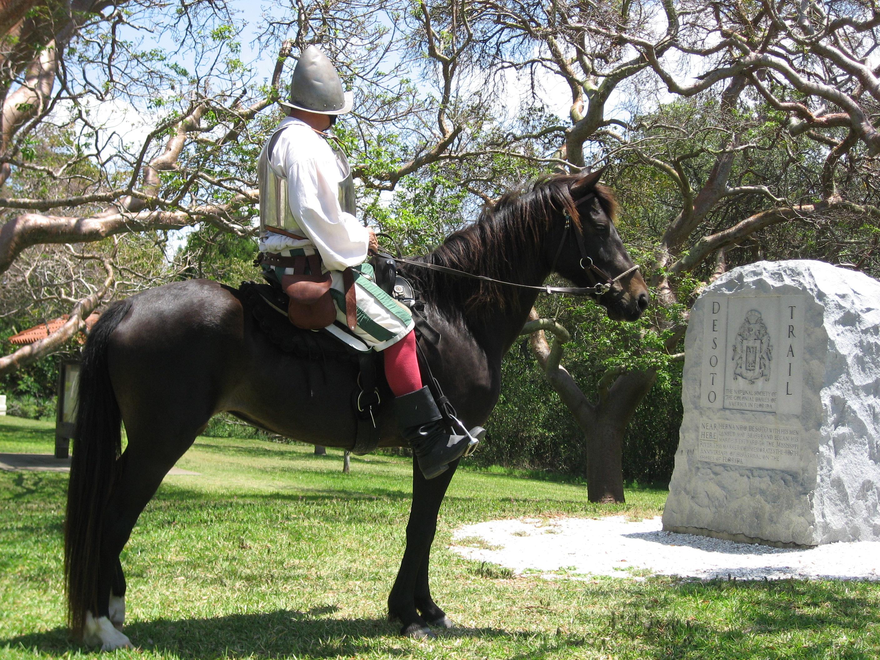
De Soto National Memorial
National Memorial
In May 1539, Conquistador Hernando de Soto’s army of soldiers, hired mercenaries, craftsmen, and clergy made landfall in Tampa Bay. They were met with fierce resistance of indigenous people protecting...
7 mi from route
~16 min detour
Free
near mile 18.1
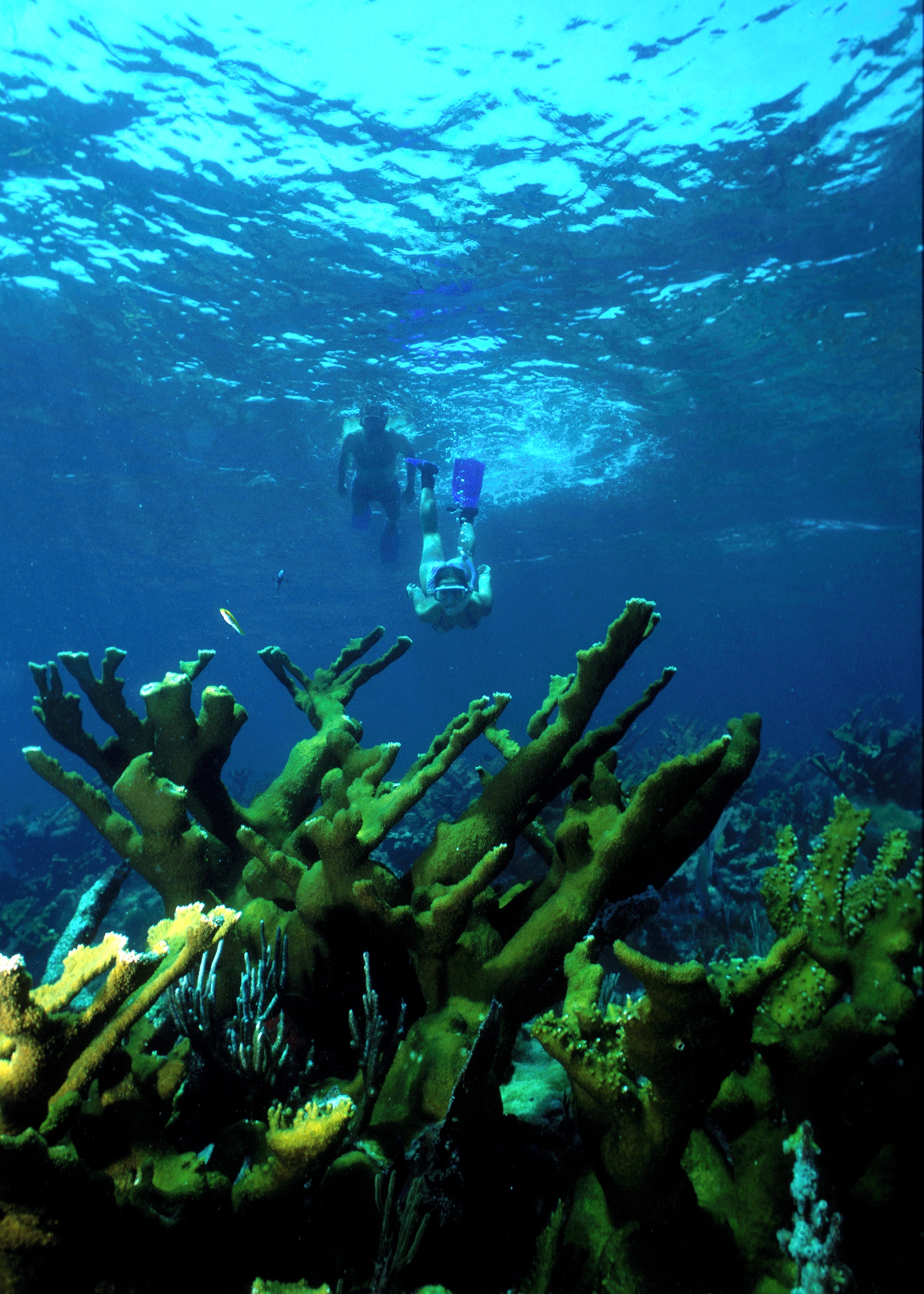
Within sight of Miami, yet worlds away, Biscayne protects a rare combination of aquamarine waters, emerald islands, and fish-bejeweled coral reefs. Evidence of 10,000 years of human history is here to...
25 mi from route
~64 min detour
Free
near mile 262.3
Park data from the National Park Service API. Alerts update every 2 hours.
More Details
What kind of drive is this?
This is a highway-focused drive, with 91% of the route utilizing major interstates. You'll experience a predominantly high-speed journey, especially during the longest stretch of 209.3 miles on I 75. Expect a consistent driving environment as you navigate through Florida's infrastructure. The character of the drive remains largely uniform due to its reliance on major thoroughfares, offering a predictable experience behind the wheel.
91% highway — fuel and pacing are the main things to plan.
30 navigation steps total — most of the decisions cluster near the start and finish.
Longest single stretch: 209.3 mi on I 75.
How Hard Is This Drive?
10/10
This is a straightforward highway drive that stays mostly on I 75 and Sunshine Skyway Bridge. This route has several spots where lane changes, forks, or exits need your full attention. The trickiest moment comes around 230.4 miles in near I 595 / Port Everglades Expressway.
Driving Effort10/10
High effort - long or complex enough to need steady focus all day
Balances navigation complexity with total wheel time.
This is a demanding drive. With 23 significant decision points across 262.3 miles, you will need to stay alert - especially through interchange areas and urban stretches. Consider splitting it into segments if you are not comfortable with fast highway navigation.
Where does it get tricky?
The main spots that need attention: at 230.4 miles (I 595 / Port Everglades Expressway): Highway fork - watch signs carefully. Lane positioning matters here. Multiple destination signs - pick the right one; at 239.5 miles: Exit ramp - move to the correct lane early. Lane positioning matters here. Multiple destination signs - pick the right one; at 240 miles: Lane positioning matters here. Multiple destination signs - pick the right one.
Elevation Profile
Mostly flat terrain
43 ft3 ft
Total Climb
31 ft
Total Descent
71 ft
Highest Point
43 ft
Elevation Range
40 ft
Towns Mentioned on Route Signs
Based on OSRM destination-sign hints, not a full list of every settlement the road passes.
Between St. Petersburg, FL and Isle of Normandy, FL, road signs point toward Fort Lauderdale, Miami, Florida's Turnpike, Orlando, Miami South and Orlando North - among others.
Saint Petersburg sits at the base of the Tampa Bay peninsula in Pinellas County, Florida, and enjoys a more subdued social atmosphere than its larger cousin, Tampa. The city has tried to characterize the downtown as an arts and entertainments destination and you will find no shortage of arts and crafts stores, galleries, and museums along with cafes and boutique food shops all within a couple blocks of the Tampa Bay waterfront. With water on three sides of the city, St. Pete is a superb location for fishing, sailing, and wandering beaches.
Top landmarks
•Salvador Dalí Museum — art museum in St. Petersburg, Florida, United States
•Vinoy Park Hotel — historic hotel in St. Petersburg, Florida, USA
•Museum of Fine Arts, St. Petersburg, Florida, USA — museum in St. Petersburg, Florida
Doable as a same-day drive at 4h 58m. Total distance: 262.3 miles.
Family Friendly
Moderate complexity with 1 natural rest stops along the way.
Solo Traveler
4h 58m drive, comfortable solo distance.
First-Time Driver
Mostly highway driving (91%). Some complex stretches to watch for.
Frequently Asked Questions
The longest stretch is about 209.3 miles on I 75. The full list of main roads is in the Roads section above.
Expect about $1.67 in tolls one way, starting with Sunshine Skyway Bridge. Most Northeast and Midwest toll agencies accept E-ZPass; in the West and Texas, transponders like TxTag or FasTrak apply. If you do not have a transponder, cashless tolling plates will mail a bill to the vehicle's registered address — usually with a surcharge, so a rental-car toll pass is often cheaper than paying by mail.
Yes — we found about 15 rest areas or service plazas within a short detour of the route (from OpenStreetMap). See the Rest Stops tab under Nearby Places for locations and mile markers. Plan to stretch, use the bathroom, and top off fluids every 2–3 hours on longer drives.
It helps. This route has a higher-than-average number of complex decision points, which get harder in the dark. If the last hour of the trip is on surface roads or mountain grades, aim to arrive at Isle of Normandy, FL before sunset when you can. Check the Trip Plan for departure windows that land you in daylight.
Only with planning. This is a long drive for kids — consider splitting it into two days rather than pushing through. Plan at least 1 meaningful breaks. There are 15 rest areas along the route for bathroom stops.
The main spots that need attention: at 230.4 miles (I 595 / Port Everglades Expressway): Highway fork - watch signs carefully. Lane positioning matters here. Multiple destination signs - pick the right one; at 239.5 miles: Exit ramp - move to the correct lane early. Lane positioning matters here. Multiple destination signs - pick the right one; at 240 miles: Lane positioning matters here. Multiple destination signs - pick the right one.
Yes — De Soto National Memorial and Biscayne National Park. See the National Parks section for detour distances and tips on detours.
Possible but tiring. At 5.0 hours each way, an in-and-out day trip would put you behind the wheel for 9.9 hours — manageable with a long break at Isle of Normandy, FL, but most travelers stay overnight.