This straightforward 76.7-mile drive from Sidney to Scottsbluff, Nebraska, is easily manageable in about 1 hour and 33 minutes, making it a perfect day trip. Primarily utilizing US Highway 385 and US 26, this route is almost entirely highway, offering a consistent driving experience. With an estimated fuel cost of $12, it's an economical option for exploring the Great Plains region. You'll find no need to split this journey, allowing for maximum flexibility in your schedule. The direct nature of this drive makes it ideal for those who prefer efficient travel between these two Nebraska communities.
Trip Pace
Same-day drive is realistic
A same-day return is realistic if you keep stops short.
Midpoint
38.3 miles from Sidney, NE
A natural place for your longest stop of the day
, about 45m into the drive
.
Main Roads
Road
Distance
Duration
US Highway 385
30.7 mi
35m
US 26
23.6 mi
27m
US 385
8.1 mi
9m
Highway 26
7.5 mi
9m
Highway L79E
2.1 mi
2m
Illinois Street
1.6 mi
2m
East 20th Street
1.2 mi
3m
Broad Street
0.6 mi
<1m
Longest stretch:
US Highway 385
— 30.7 mi, about 35m
Turn-by-Turn Driving Directions
Step-by-step road directions between Sidney, NE and Scottsbluff, NE.
1
Start on 11th Avenue
26 ft·3 sec·11th Avenue
2
Turn right onto King Street
349 ft·20 sec·King Street
3
Turn left onto 10th Avenue
0.1 mi·18 sec·10th Avenue
4
Turn right onto US 30; I 80 Alt
1.6 mi·2 min·Illinois Street
5
At end of road, turn left onto US 30; I 80 Alt
0.3 mi·33 sec·US Highway 30
6
Continue on US 385
12 mi·13 min·US Highway 385
7
Continue on US 385
0.5 mi·43 sec·Front Street
8
Continue on US 385
5.4 mi·6 min·US Highway 385
9
Continue on US 385
0.6 mi·53 sec·Broad Street
10
Continue on US 385
13 mi·15 min·US Highway 385
11
At end of road, turn left onto US 385; N-92
8.1 mi·9 min·US 385; N-92
12
Turn left onto US 26; N-92
24 mi·27 min·US 26; N-92
13
Turn right onto L-79E
2.1 mi·2 min·Highway L79E
14
Turn left onto US 26
7.5 mi·9 min·Highway 26
15
Turn left onto East 20th Street
1.2 mi·3 min·East 20th Street
16
Continue on West 20th Street
0.2 mi·39 sec·West 20th Street
17
Turn right onto Avenue C
54 ft·2 sec·Avenue C
18
Arrive at destination
Avenue C
Trip Plan
Given its short 1 hour and 33-minute duration, this route offers considerable flexibility; you can depart Sidney whenever it suits you. Plan to fuel up before you leave Sidney, as there are no designated stops on this route and the longest stretch without a change in road is over 30 miles. The estimated fuel cost is a modest $12, so budget accordingly. Keep an eye on your speedometer, especially as you transition between US Highway 385 and US 26, to ensure you're adhering to posted limits. This drive is best enjoyed with minimal interruption, focusing on reaching Scottsbluff efficiently.
Morning Departure
Leave by 9 AM and you'll arrive before lunch.
Evening Departure
Even a 4 PM departure gets you there before dark in summer.
You can normally do this drive in one day.
You may only need one short stretch break if traffic stays light.
The halfway point lands around 38.3 miles from Sidney, NE, or about 45m into the drive.
The longest continuous stretch on this route runs about 30.7 miles.
This is a comfortable same-day trip.
Departure
Before you leave
Start with fuel, water, and navigation already sorted so the first hour feels easy.
First stop
Around 17 miles or 20m in
Use this first pause for coffee, a restroom break, and a quick traffic check ahead.
Halfway reset
Around 38.3 miles or 45m in
This is the best place for your longest stop, a real meal, and a full fuel check.
Final approach
Final hour starts around 1h 17m
Traffic, exits, and arrival timing usually matter more near Scottsbluff, NE than in the middle of the route.
Before You Leave
+
Open the route before leaving Sidney, NE so your first major turns are already loaded.
Day 1
Settle into the route from Sidney, NE
This is one driving day of about 76.7 miles and 1h 33m.
Your first comfortable stop window is around 17 miles from Sidney, NE.
This route can stay practical as a one-day drive if traffic stays reasonable.
The longest stretch is on US Highway 385 for about 30.7 miles.
Where to Stop
Rest stops, refuel points, and overnight suggestions along this route.
Place data sourced from public business listings. Hours and availability may vary.
Heads-up: tricky spots
5 of 8
5 decision points cluster between mile 0 and 76.7 — GPS handles the exact turns, but know they're coming. Your lane choice matters more than the turn itself.
5
0 mi into trip|~0m in|King Street
Turn right onto King Street
Navigation decision point
5
0.1 mi into trip|~0m in|10th Avenue
Turn left onto 10th Avenue
Navigation decision point
5
33.9 mi into trip|~40m in|US 385; N-92
At end of road, turn left onto US 385; N-92
Navigation decision point
4
42.1 mi into trip|~50m in|US 26; N-92
Turn left onto US 26; N-92
Navigation decision point
5
76.7 mi into trip|~1h 33m in|Avenue C
Turn right onto Avenue C
Navigation decision point
Fuel & Cost
Regular Gas
$11.99 one way
$23.98 round trip
$3.97/gal25.4 MPG avg27 kg CO2
Fuel Type
$/gal
One Way
Round Trip
midgrade
$4.36
$13.17
$26.33
premium
$4.89
$14.76
$29.52
diesel
$5.61
$16.93
$33.87
No toll roads detected on this route.
Estimated Trip Cost (one way, 1 person)
Fuel
$12
Meals
$25–$50
Total
$37–$62
Rough estimate based on US averages. Hotel $80–$140/night, meals $25–$50/day.
Estimated CO2 emission: 26.8 kg one way.
Prices: EIA weekly data, 2026-04-13.
Driving Electric?
About $8 in charging
· 0 stops
· 67% less CO2
Vehicle Type
kWh
Stops
DC Fast
Home Charge
Average EV
23
0
$8.05
$3.68
Efficient EV
19.2
0
$6.71
$3.07
EV Truck/SUV
30.7
0
$10.74
$4.91
Gas CO2
27 kg
EV CO2
9 kg (67% less)
This trip is well within single-charge range for most EVs. No charging stops needed if you start fully charged.
DC fast charging avg $0.35/kWh. Home charging avg $0.16/kWh. US grid CO2: 0.39 kg/kWh.
Travel Intel
Current conditions at both ends of the drive.
Forecast as of Apr 15, 2026
Origin
Sidney, NE
Late night
in Sidney on Sunday
Local time
12:02 AM
MDT
Current temp
81°F
Unavailable
Live forecast
Destination
Scottsbluff, NE
Late night
in Scottsbluff on Sunday
Local time
12:02 AM
MDT
Current temp
81°F
Unavailable
Live forecast
81°F
Bridgeport, NE
38 mi in
Seasonal Notes
Summer travel usually means heavier construction, hotter rest stops, and busier weekend traffic around major cities.
Winter travel shortens daylight, so a route that looks manageable on paper can feel much longer after dark.
Holiday weekends tend to make both departure and arrival windows slower than the raw route time suggests.
Time zone
Same local time
Origin and destination are on the same clock, so arrival timing is easier to judge at a glance.
Temperature spread
Very similar conditions
Both ends of the route are sitting at about the same temperature right now.
Road read
1h 33m on the road
Use the two city cards together: check the sky where you start, then compare it with the local time and temperature at arrival.
Weather data from the National Weather Service. Conditions may change; check closer to your travel date.
National Parks Near This Route
Worth a detour if your schedule allows.
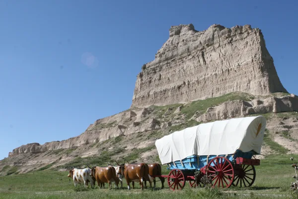
Scotts Bluff National Monument
National Monument
Towering 800 feet above the North Platte River, Scotts Bluff has served as a landmark for peoples from Native Americans to emigrants on the Oregon, California and Mormon Trails to modern travelers. Ri...
Park data from the National Park Service API. Alerts update every 2 hours.
More Details
What kind of drive is this?
Expect a highway-focused experience for 92% of this 76.7-mile journey. You'll spend most of your time on US Highway 385 and US 26, which are well-maintained and conducive to steady travel. The longest uninterrupted stretch you'll encounter is 30.7 miles on US Highway 385, providing a good opportunity to settle into a rhythm. While the profile is largely highway, the landscape of the Great Plains will likely offer a consistent, open-country backdrop. This drive is characterized by its directness and efficiency on the open road.
92% highway — fuel and pacing are the main things to plan.
18 navigation steps total — most of the decisions cluster near the start and finish.
Longest single stretch: 30.7 mi on US Highway 385.
How Hard Is This Drive?
3/10
This is a straightforward highway drive that stays mostly on US Highway 385 and US 26. There are only a few real navigation decisions along the way. The trickiest moment comes early in the drive near King Street.
Driving Effort3/10
Easy - simple navigation with a manageable amount of wheel time
Balances navigation complexity with total wheel time.
This is a straightforward 1h 33m drive. You will face about 8 decision points, but nothing that requires special attention if you follow navigation.
Where does it get tricky?
The main spots that need attention: near the start (King Street): Navigation decision point; at 0.1 miles (10th Avenue): Navigation decision point; at 33.9 miles (US 385; N-92): Navigation decision point.
Elevation Profile
Mostly flat terrain
4,259 ft3,661 ft
Total Climb
432 ft
Total Descent
633 ft
Highest Point
4,259 ft
~11 mi in
Elevation Range
598 ft
Notable High Points
4,259 ft at ~11 miles+2 ft prominence
Who Is This Route For?
Weekend Trip
Doable as a same-day drive at 1h 33m. Total distance: 76.7 miles.
Family Friendly
Moderate complexity with 0 natural rest stops along the way.
The longest stretch is about 30.7 miles on US Highway 385. The full list of main roads is in the Roads section above.
Yes. At under 2 hours behind the wheel, this works well for families — plan one quick stop if you have younger kids.
Mostly yes along the main roads, but rural stretches through NE can have sparse or no coverage. Before you leave, download offline Google Maps or Apple Maps for the route, and consider downloading music or podcasts instead of streaming. If you depend on data for navigation, keep a paper backup of the turn-by-turn directions.
The main spots that need attention: near the start (King Street): Navigation decision point; at 0.1 miles (10th Avenue): Navigation decision point; at 33.9 miles (US 385; N-92): Navigation decision point.
Yes — Scotts Bluff National Monument. See the National Parks section for detour distances and tips on detours.
Yes. A round trip is manageable in a single day if you plan a break at Scottsbluff, NE before heading back.