Traveling from Patoka to Terre Haute covers 77.4 miles and typically takes about 1 hour and 38 minutes. This straightforward journey is best suited as a single-day trip, as it is short enough to navigate without needing an overnight stay. You will primarily utilize US 41, eventually transitioning onto Main Street and North 3rd Street to reach your destination. With an estimated fuel cost of $12, the trip is quite budget-friendly for a quick regional transit. Both locations are situated within the Midwest, keeping the scenery and atmosphere consistent throughout the drive. It is a practical, no-nonsense route that efficiently connects these two Indiana points.
Trip Pace
Same-day drive is realistic
A same-day return is realistic if you keep stops short.
Midpoint
38.7 miles from Patoka, IN
A natural place for your longest stop of the day
, about 47m into the drive
.
Main Roads
Road
Distance
Duration
US 41
76.9 mi
1h 37m
Main Street
0.5 mi
<1m
North 3rd Street
—
—
Some road-level metrics are being recalculated.
Longest stretch:
US 41
— 76.9 mi, about 1h 37m
Turn-by-Turn Driving Directions
Step-by-step road directions between Patoka, IN and Terre Haute, IN.
1
Start on Main Street
0.5 mi·57 sec·Main Street
2
Turn right onto US 41
21 mi·23 min·US 41
3
Take the exit onto US 41; US 150
56 mi·1 hr 13 min·US 41; US 150
Toward US 41 North, US 150: Terre HauteUse the straight lane.
4
Arrive at destination
US 41; US 150
Trip Plan
Since the trip is a manageable 1 hour and 38 minutes, you have significant flexibility regarding your departure time. You can easily complete the entire 77.4-mile trek without needing any scheduled stops, though keeping an eye on your fuel gauge is wise given the $12 estimated cost. Because the route is almost entirely highway-based, ensure your vehicle is ready for sustained speeds on US 41. If you are traveling during peak hours, keep in mind that the transition from the open highway onto North 3rd Street may involve a change in traffic density. Use the simplicity of this direct path to your advantage by planning your arrival to coincide with your specific local appointments in Terre Haute.
Morning Departure
Leave by 9 AM and you'll arrive before lunch.
Evening Departure
Even a 4 PM departure gets you there before dark in summer.
You can normally do this drive in one day.
You may only need one short stretch break if traffic stays light.
The halfway point lands around 38.7 miles from Patoka, IN, or about 47m into the drive.
The longest continuous stretch on this route runs about 76.9 miles.
This is a comfortable same-day trip.
Departure
Before you leave
Start with fuel, water, and navigation already sorted so the first hour feels easy.
First stop
Around 17 miles or 19m in
Use this first pause for coffee, a restroom break, and a quick traffic check ahead.
Halfway reset
Around 38.7 miles or 47m in
This is the best place for your longest stop, a real meal, and a full fuel check.
Final approach
Final hour starts around 1h 23m
Traffic, exits, and arrival timing usually matter more near Terre Haute, IN than in the middle of the route.
Before You Leave
+
Open the route before leaving Patoka, IN so your first major turns are already loaded.
Day 1
Settle into the route from Patoka, IN
This is one driving day of about 77.4 miles and 1h 38m.
Your first comfortable stop window is around 17 miles from Patoka, IN.
This route can stay practical as a one-day drive if traffic stays reasonable.
The longest stretch is on US 41 for about 76.9 miles.
Where to Stop
Rest stops, refuel points, and overnight suggestions along this route.
Place data sourced from public business listings. Hours and availability may vary.
Heads-up: tricky spots
2 of 2
2 decision points cluster between mile 0.5 and 21.5 — GPS handles the exact turns, but know they're coming. Your lane choice matters more than the turn itself.
3
0.5 mi into trip|~0m in|US 41
Turn right onto US 41
Navigation decision point
7
21.5 mi into trip|~24m in|US 41; US 150
Take the exit onto US 41; US 150 toward US 41 North, US 150: Terre Haute
Exit ramp - move to the correct lane early. Lane positioning matters here. Multiple destination signs - pick the right one
Use the straight lane.
Toward US 41 North, US 150: Terre Haute
Fuel & Cost
Regular Gas
$12.10 one way
$24.20 round trip
$3.97/gal25.4 MPG avg27 kg CO2
Fuel Type
$/gal
One Way
Round Trip
midgrade
$4.36
$13.29
$26.57
premium
$4.89
$14.89
$29.79
diesel
$5.61
$17.09
$34.18
No toll roads detected on this route.
Estimated Trip Cost (one way, 1 person)
Fuel
$12
Meals
$25–$50
Total
$37–$62
Rough estimate based on US averages. Hotel $80–$140/night, meals $25–$50/day.
Estimated CO2 emission: 27.1 kg one way.
Prices: EIA weekly data, 2026-04-13.
Driving Electric?
About $8 in charging
· 0 stops
· 67% less CO2
Vehicle Type
kWh
Stops
DC Fast
Home Charge
Average EV
23.2
0
$8.13
$3.72
Efficient EV
19.4
0
$6.77
$3.10
EV Truck/SUV
31
0
$10.84
$4.95
Gas CO2
27 kg
EV CO2
9 kg (67% less)
This trip is well within single-charge range for most EVs. No charging stops needed if you start fully charged.
DC fast charging avg $0.35/kWh. Home charging avg $0.16/kWh. US grid CO2: 0.39 kg/kWh.
Travel Intel
Current conditions at both ends of the drive.
Forecast as of Apr 14, 2026
Origin
Patoka, IN
Late night
in Patoka on Sunday
Local time
5:14 AM
CDT
Current temp
75°F
Unavailable
Live forecast
Destination
Terre Haute, IN
Morning
in Terre Haute on Sunday
Local time
6:14 AM
EDT
Current temp
68°F
Mostly Cloudy
SSW 13 mph12% chanceLive forecast
Flood Warning
Flood Warning issued April 13 at 10:37PM EDT until April 17 at 8:00AM EDT by NWS Northern Indiana
Flood Warning
Flood Warning issued April 13 at 6:31PM CDT until April 15 at 7:00AM CDT by NWS Chicago IL
Seasonal Notes
Summer travel usually means heavier construction, hotter rest stops, and busier weekend traffic around major cities.
Winter travel shortens daylight, so a route that looks manageable on paper can feel much longer after dark.
Holiday weekends tend to make both departure and arrival windows slower than the raw route time suggests.
Time zone
1 hour later
The destination clock does not match departure time, so double-check hotel check-in windows and late arrival plans.
Temperature spread
7 degrees cooler at arrival
A meaningful temperature swing is a good cue to rethink layers, water, and how soon you want to arrive.
Road read
1h 38m on the road
The weather snapshot is not static. If you are leaving later, give both cities one more quick forecast check before departure.
Weather data from the National Weather Service. Conditions may change; check closer to your travel date.
National Parks Near This Route
Worth a detour if your schedule allows.
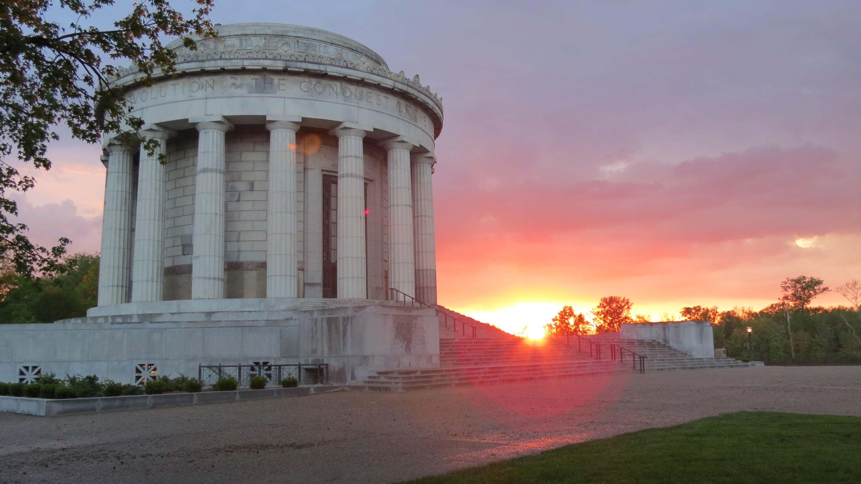
George Rogers Clark National Historical Park
National Historical Park
The British flag would not be raised above Fort Sackville Feb. 25, 1779. At 10 A.M., the garrison surrendered to American Colonel George Rogers Clark. His American army, aided by French residents of t...
Park data from the National Park Service API. Alerts update every 2 hours.
More Details
What kind of drive is this?
Expect a focused, highway-heavy experience, as 99% of this route consists of high-speed transit. You will spend the vast majority of your time on US 41, which accounts for a 76.9-mile stretch of the journey. Because this is a highway-focused drive, the pace remains consistent and predictable from start to finish. You won't encounter many technical turns or winding local roads until you reach the final approach into Terre Haute. Behind the wheel, you should prepare for a steady, direct commute that prioritizes speed and efficiency over secondary road exploration.
99% highway — fuel and pacing are the main things to plan.
4 navigation steps total — most of the decisions cluster near the start and finish.
Longest single stretch: 76.9 mi on US 41.
How Hard Is This Drive?
1/10
This is a straightforward highway drive that stays mostly on US 41 and Main Street. Navigation is very simple - set it and forget it for most of the drive. The trickiest moment comes around 0.5 miles in near US 41.
Driving Effort1/10
Very easy - short and simple to drive
Balances navigation complexity with total wheel time.
The drive from Patoka, IN to Terre Haute, IN is easy. At 1h 38m with 99% highway, most drivers will find it relaxed and low-stress.
Where does it get tricky?
The main spots that need attention: at 0.5 miles (US 41): Navigation decision point; at 21.5 miles (US 41; US 150): Exit ramp - move to the correct lane early. Lane positioning matters here. Multiple destination signs - pick the right one.
Who Is This Route For?
Weekend Trip
Doable as a same-day drive at 1h 38m. Total distance: 77.4 miles.
Family Friendly
Moderate complexity with 0 natural rest stops along the way.
The longest stretch is about 76.9 miles on US 41. The full list of main roads is in the Roads section above.
Yes. At under 2 hours behind the wheel, this works well for families — plan one quick stop if you have younger kids.
The main spots that need attention: at 0.5 miles (US 41): Navigation decision point; at 21.5 miles (US 41; US 150): Exit ramp - move to the correct lane early. Lane positioning matters here. Multiple destination signs - pick the right one.
Yes — George Rogers Clark National Historical Park. See the National Parks section for detour distances and tips on detours.
Yes. A round trip is manageable in a single day if you plan a break at Terre Haute, IN before heading back.