Traveling from Ouray to Denver covers 301.3 miles and takes approximately 5 hours and 28 minutes of drive time. This route stays entirely within the Mountain West region of Colorado, making it a straightforward, single-day journey. You should budget about $46 for fuel to complete the trip. Because the drive is under six hours, you can comfortably finish it in one day without needing an overnight stay. It serves as a practical connection between the high-altitude landscapes of Ouray and the urban center of Denver.
Trip Pace
Same-day drive is realistic
A same-day return is possible, but it will make for a full day on the road.
Break Rhythm
1 planned break
Plan on a short reset every 3 to 4 hours to stay fresh behind the wheel.
Midpoint
166.2 miles from Ouray, CO
A natural place for your longest stop of the day
, about 3h 28m into the drive
.
Main Roads
Road
Distance
Duration
I 70 BUS
226.5 mi
4h 14m
US 50
43.5 mi
52m
Main Street
36.3 mi
49m
West 6th Avenue Freeway
10.1 mi
14m
32 Road
5.4 mi
9m
North Townsend Avenue
3.7 mi
6m
G Road
2.3 mi
4m
G50 Road
2.1 mi
3m
Longest stretch:
I 70 BUS
— 226.5 mi, about 4h 14m
Traffic on I-70
Hour-of-day weekday pattern from 16 FHWA count stations on your route.
Peak
4 PM
~1,405 veh/hr typical
· worst 1,990
Quietest
2 AM
~79 veh/hr
Peak-to-quiet ratio
17.8×
busier at peak than in the quiet hours
12a6anoon6p11p
Averaged across 52 weeks of 2023 FHWA Travel Monitoring Analysis System data. Weekday hours only (Mon–Fri).
Turn-by-Turn Driving Directions
Step-by-step road directions between Ouray, CO and Denver, CO.
1
Start on 6th Avenue
12 ft·2 sec·6th Avenue
2
Turn right onto US 550
36 mi·49 min·Main Street
Use the straight / right lanes.
3
Continue on US 550
3.7 mi·6 min·North Townsend Avenue
Use the straight lane.
4
Continue on US 50
17 mi·20 min·US 50
5
Turn left onto Confluence Drive
0.8 mi·1 min·Confluence Drive
Use the left lane.
6
Turn left onto West 5th Street
0.2 mi·26 sec·West 5th Street
Use the left lane.
7
Continue on G Road
1.6 mi·3 min·G Road
8
Continue on G Road
0.7 mi·1 min·G Road
9
Continue on G50 Road
2.1 mi·3 min·G50 Road
10
At end of road, turn left onto US 50
15 mi·17 min·US 50
11
Continue on US 50
12 mi·14 min·US 50
12
Continue on CO 141
5.4 mi·9 min·32 Road
Use the left / straight lanes.
13
Turn right onto I 70 BUS; US 6
0.3 mi·34 sec·I 70 BUS; US 6
14
Continue on I 70 BUS; US 6
0.8 mi·1 min·I 70 BUS; US 6
15
Keep slight right at fork onto I 70 BUS
225 mi·4 hr 12 min·I 70 BUS
Toward I 70 East: DenverUse the slight right lane.
16
Take the exit
0.3 mi·43 sec
Exit 261Toward US 6 East: 6th Avenue, LakewoodUse the slight right lane.
17
Merge onto US 6
10 mi·14 min·West 6th Avenue Freeway
Use the straight / slight right lanes.
18
Turn left onto North Lincoln Street
0.9 mi·2 min·North Lincoln Street
Use the straight / left lanes.
19
Turn right onto East 14th Avenue
353 ft·17 sec·East 14th Avenue
Use the right lane.
20
Turn left
358 ft·27 sec
Use the straight / left lanes.
21
Arrive at destination
Trip Plan
Planning your departure early in the day is wise to account for the technical, turn-heavy nature of these local roads. Since you only have one recommended stop during the 301.3-mile journey, try to time your break to coincide with a refueling stop to stay within your $46 gas budget. Keep a close eye on your navigation, as the transition between Main Street and Confluence Drive requires steady attention. The flexibility of this one-day trip allows you to adjust your pace based on local traffic conditions. Staying alert is essential, as the lack of highway miles means you will be managing frequent speed changes throughout the entire drive.
Morning Departure
Start early — leave by 6-7 AM to arrive at a reasonable hour.
Evening Departure
This is a long drive — plan for a morning departure or consider splitting it into two days.
You can normally do this drive in one day.
Plan roughly 1 meaningful break for fuel, food, and rest.
The halfway point lands around 166.2 miles from Ouray, CO, or about 3h 28m into the drive.
The longest continuous stretch on this route runs about 226.5 miles.
This is a comfortable same-day trip.
Departure
Before you leave
Start with fuel, water, and navigation already sorted so the first hour feels easy.
First stop
Around 73 miles or 1h 38m in
Use this first pause for coffee, a restroom break, and a quick traffic check ahead.
Halfway reset
Around 166.2 miles or 3h 28m in
This is the best place for your longest stop, a real meal, and a full fuel check.
Final approach
Final hour starts around 5h 28m
Traffic, exits, and arrival timing usually matter more near Denver, CO than in the middle of the route.
Before You Leave
+
Open the route before leaving Ouray, CO so your first major turns are already loaded.
+
Leave with enough water and a charging cable within reach, not packed away.
+
Check your fuel range against the first long segment, especially if you are starting outside city service areas.
Day 1
Settle into the route from Ouray, CO
This is one driving day of about 332.4 miles and 6h 40m.
Your first comfortable stop window is around 73 miles from Ouray, CO.
This route can stay practical as a one-day drive if traffic stays reasonable.
Plan about 1 real break rather than only quick fuel stops.
The longest stretch is on I 70 BUS for about 226.5 miles.
Where to Stop
Rest stops, refuel points, and overnight suggestions along this route.
Place data sourced from public business listings. Hours and availability may vary.
Heads-up: tricky spots
5 of 10
5 decision points cluster between mile 0 and 332.4 — GPS handles the exact turns, but know they're coming. Your lane choice matters more than the turn itself.
6
0 mi into trip|~0m in|US 550 / Main Street
Turn right onto US 550 / Main Street
Lane positioning matters here
Use the straight / right lanes.
6
58 mi into trip|~1h 18m in|West 5th Street
Turn left onto West 5th Street
Lane positioning matters here
Use the left lane.
7
95.6 mi into trip|~2h 9m in|I 70 BUS
Keep slight right at fork onto I 70 BUS toward I 70 East: Denver
Highway fork - watch signs carefully. Lane positioning matters here
Use the slight right lane.
Toward I 70 East: Denver
8
321 mi into trip|~6h 22m in
Take the exit toward US 6 East: 6th Avenue, Lakewood
Exit ramp - move to the correct lane early. Lane positioning matters here. Multiple destination signs - pick the right one
Use the slight right lane.
Exit 261
Toward US 6 East: 6th Avenue, Lakewood
7
332.4 mi into trip|~6h 40m in
Turn left
Lane positioning matters here
Use the straight / left lanes.
Fuel & Cost
Regular Gas
$50.68 one way
$101.37 round trip
$3.87/gal25.4 MPG avg116 kg CO2
Fuel Type
$/gal
One Way
Round Trip
midgrade
$4.12
$53.88
$107.76
premium
$4.45
$58.27
$116.55
diesel
$4.80
$62.76
$125.53
No toll roads detected on this route.
Estimated Trip Cost (one way, 1 person)
Fuel
$51
Meals
$25–$50
Total
$76–$101
Rough estimate based on US averages. Hotel $80–$140/night, meals $25–$50/day.
Estimated CO2 emission: 116.3 kg one way.
Prices: EIA weekly data, 2026-07-13.
Driving Electric?
About $35 in charging
· 1 stop
· 66% less CO2
Vehicle Type
kWh
Stops
DC Fast
Home Charge
Average EV
99.7
1
$34.90
$15.96
Efficient EV
83.1
0
$29.09
$13.30
EV Truck/SUV
133
1
$46.54
$21.27
Gas CO2
116 kg
EV CO2
39 kg (66% less)
Plan for 1 charging stop. A 30-minute DC fast charge mid-route should be enough to complete the trip comfortably.
DC fast charging avg $0.35/kWh. Home charging avg $0.16/kWh. US grid CO2: 0.39 kg/kWh.
Travel Intel
Current conditions at both ends of the drive.
Forecast as of Jul 17, 2026
Origin
Ouray, CO
Evening
in Ouray on Saturday
Local time
7:30 PM
MDT
Current temp
76°F
Showers And Thunderstorms
WNW 0 to 5 mph83% chanceLive forecast
Destination
Denver, CO
Evening
in Denver on Saturday
Local time
7:30 PM
MDT
Current temp
95°F
Sunny
NE 3 to 8 mph2% chanceLive forecast
Seasonal Notes
Summer travel usually means heavier construction, hotter rest stops, and busier weekend traffic around major cities.
Winter travel shortens daylight, so a route that looks manageable on paper can feel much longer after dark.
Holiday weekends tend to make both departure and arrival windows slower than the raw route time suggests.
Time zone
Same local time
Origin and destination are on the same clock, so arrival timing is easier to judge at a glance.
Temperature spread
19 degrees warmer at arrival
A meaningful temperature swing is a good cue to rethink layers, water, and how soon you want to arrive.
Road read
6h 40m on the road
Start early — leave by 6-7 AM to arrive at a reasonable hour.
Weather data from the National Weather Service. Conditions may change; check closer to your travel date.
National Parks Near This Route
Worth a detour if your schedule allows.
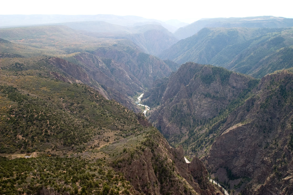
Black Canyon Of The Gunnison National Park
National Park
Big enough to be overwhelming, yet still intimate enough to feel the pulse of time. Come see some of the steepest cliffs, oldest rock, and craggiest spires in North America. Forces of nature and the G...
11 mi from route
~29 min detour
$30
near mile 34.4
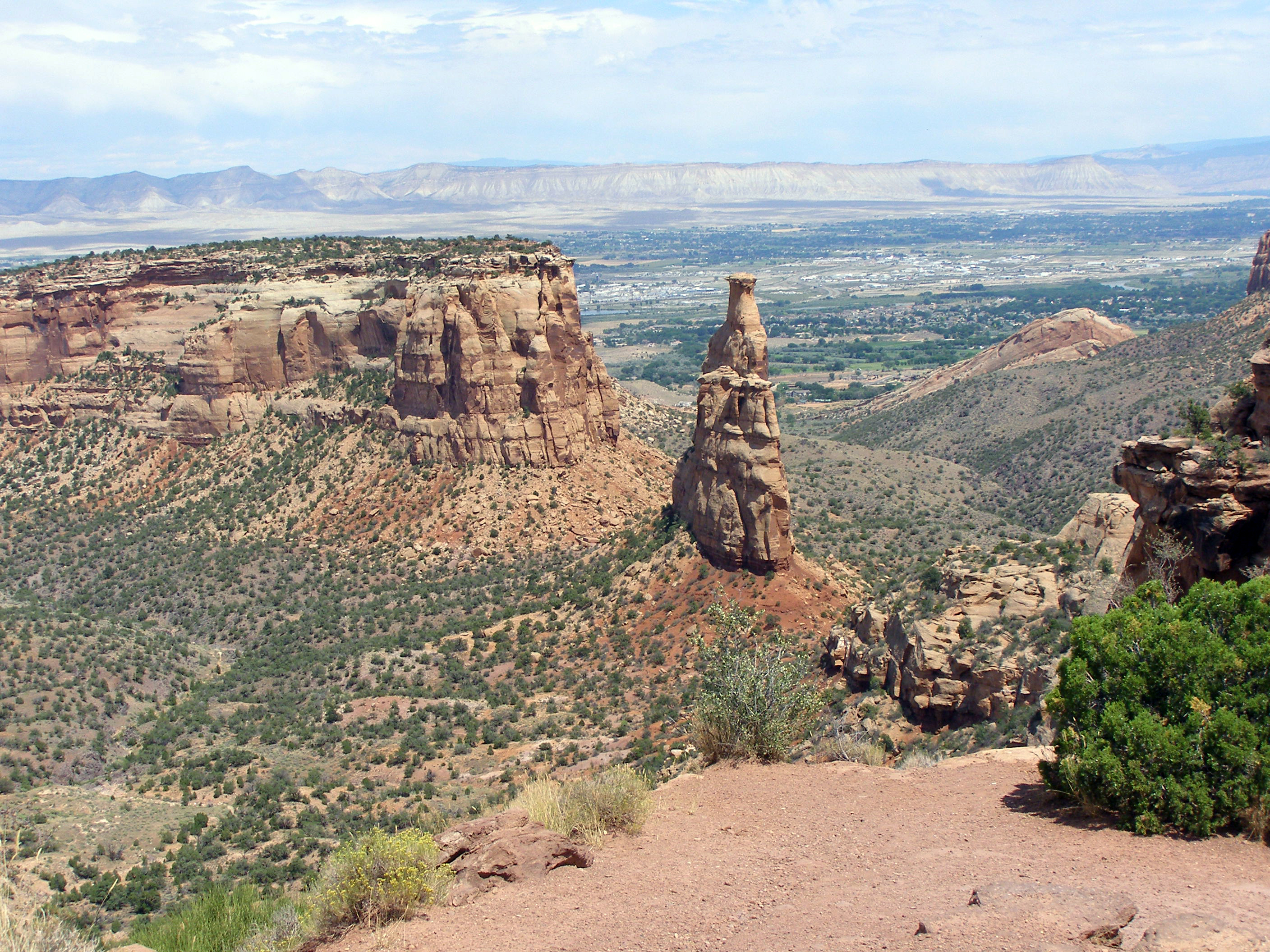
Colorado National Monument preserves one of the grand landscapes of the American West. But this treasure is much more than a monument. Towering monoliths exist within a vast plateau and canyon panoram...
12 mi from route
~31 min detour
$25
near mile 91.7
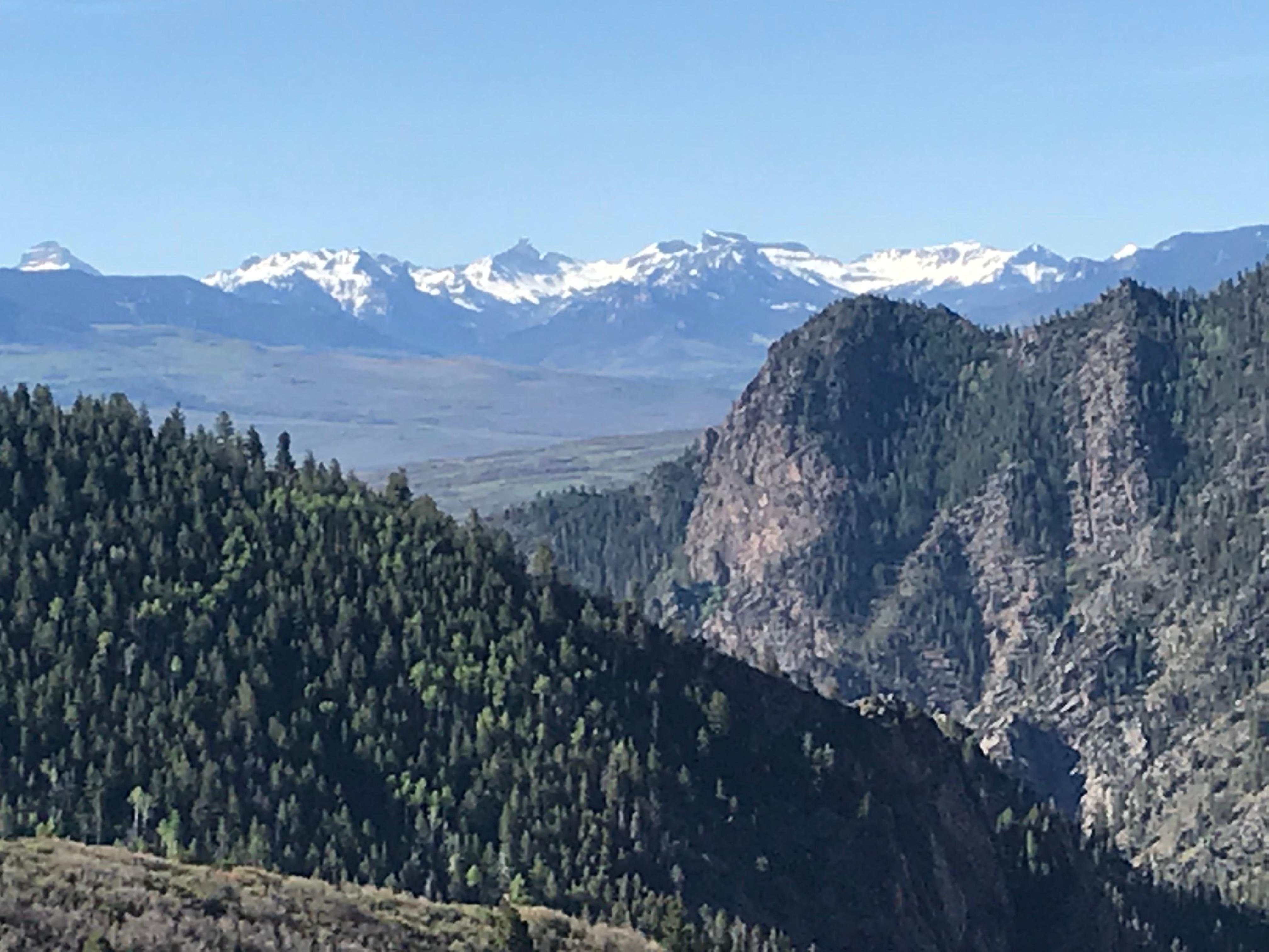
Three reservoirs and surrounding lands make up this recreation area in western Colorado. It is a landscape of tradeoffs; natural and human made features exist together. Geologic wonders are abundant f...
26 mi from route
~66 min detour
Free
near mile 22.9
Park data from the National Park Service API. Alerts update every 2 hours.
More Details
What kind of drive is this?
Expect a turn-heavy local drive rather than a monotonous interstate cruise, as this route features a 0% highway share. You will navigate through local roads like Main Street, North Townsend Avenue, and Confluence Drive, which require your full attention behind the wheel. The road's personality is defined by its winding nature, demanding consistent focus as you transition between towns. This technical layout ensures that the 5-hour and 28-minute duration feels active and engaging, offering a distinct departure from standard highway travel.
84% highway — fuel and pacing are the main things to plan.
21 navigation steps total — most of the decisions cluster near the start and finish.
Longest single stretch: 226.5 mi on I 70 BUS.
How Hard Is This Drive?
5/10
This is a straightforward highway drive that stays mostly on I 70 BUS and US 50. You will hit about 10 points where you need to pay attention to lane position or signs. The trickiest moment comes early in the drive near US 550 / Main Street.
Driving Effort5/10
Moderate - straightforward overall, but long enough or busy enough to require pacing
Balances navigation complexity with total wheel time.
This drive requires moderate attention. Across 332.4 miles you will encounter 10 spots where lane choice or exit timing matters. Not difficult for experienced highway drivers, but worth previewing the tricky sections before you go.
Where does it get tricky?
The main spots that need attention: near the start (US 550 / Main Street): Lane positioning matters here; at 58 miles (West 5th Street): Lane positioning matters here; at 95.6 miles (I 70 BUS): Highway fork - watch signs carefully. Lane positioning matters here.
Elevation Profile
Mountain driving with significant elevation changes
Ouray is a small town in Southwestern Colorado, magnificently situated in the San Juan Mountains and nicknamed "The Switzerland of America" for its scenery and outdoor recreational opportunities.
Denver is the capital of the western U.S. state of Colorado and the dominant city of the Rocky Mountain Region. Founded in 1858 as the placer gold mining camp known as the Cherry Creek Diggings, the "Mile-High City" is today the most populous city within a 560-mile (900 km) radius and the center of the Front Range Urban Corridor of more than five million residents. Denver embraces its cowboy and mining past but also looks toward the future with a vibrant arts and performing arts scene, dozens of great outdoor festivals, and distinct neighborhoods each offering a unique experience. You'll find everything a cosmopolitan city has to offer including a spectacular view of and easy access to the beautiful Rocky Mountains, which arise only 12 miles (19 km) west of the Colorado State Capitol.
Top landmarks
•Denver Art Museum — museum in Denver, Colorado, United States
•Denver Mint — United States Mint branch in Denver, Colorado
•Cathedral Basilica of the Immaculate Conception — church in Colorado, United States
Doable as a same-day drive at 6h 40m. Total distance: 332.4 miles.
Family Friendly
Moderate complexity with 1 natural rest stops along the way.
Solo Traveler
6h 40m drive, plan rest stops for pacing.
First-Time Driver
Mostly highway driving (84%). Some complex stretches to watch for.
Frequently Asked Questions
The longest stretch is about 226.5 miles on I 70 BUS. The full list of main roads is in the Roads section above.
Yes — we found about 13 rest areas or service plazas within a short detour of the route (from OpenStreetMap). See the Rest Stops tab under Nearby Places for locations and mile markers. Plan to stretch, use the bathroom, and top off fluids every 2–3 hours on longer drives.
It helps. This is a long drive, so arriving tired and in the dark compounds. If the last hour of the trip is on surface roads or mountain grades, aim to arrive at Denver, CO before sunset when you can. Check the Trip Plan for departure windows that land you in daylight.
Only with planning. This is a long drive for kids — consider splitting it into two days rather than pushing through. Plan at least 1 meaningful breaks. There are 13 rest areas along the route for bathroom stops.
The main spots that need attention: near the start (US 550 / Main Street): Lane positioning matters here; at 58 miles (West 5th Street): Lane positioning matters here; at 95.6 miles (I 70 BUS): Highway fork - watch signs carefully. Lane positioning matters here.
Yes — Black Canyon Of The Gunnison National Park, Colorado National Monument and Curecanti National Recreation Area. See the National Parks section for detour distances and tips on detours.
Not recommended in a single day. At 6.7 hours each way, a round trip means 13.3 hours of driving — that is an unsafe level of fatigue for most drivers. Plan at least one night at Denver, CO before the return drive.