This 436.8-mile journey from Ontario, OR to Grants Pass, OR will take approximately 10 hours and 37 minutes to complete. With a fuel cost estimated at $87, it's a significant drive that's best split over two days, especially considering its turn-heavy local road profile. The route primarily utilizes Central Oregon Highway and Christmas Valley Highway, with a small portion on US 395, making for a more engaging, less highway-dominated experience. You'll be traveling within the Pacific Coast region for both your origin and destination, suggesting a consistent regional feel throughout the drive. Plan for around three stops to break up the travel time.
Trip Pace
Best split across 2 days
Treat the return leg as its own travel day rather than an afterthought.
Break Rhythm
3 planned breaks
Plan on a short reset every 3 to 4 hours to stay fresh behind the wheel.
Midpoint
218.4 miles from Ontario, OR
A natural place for your longest stop of the day
, about 5h 45m into the drive
.
Main Roads
Road
Distance
Duration
Central Oregon Highway
123.3 mi
3h 42m
Christmas Valley Highway
41.2 mi
56m
US 395
37.1 mi
43m
Silver Lake Road
35.6 mi
48m
Lake of the Woods Highway
32.3 mi
36m
Oregon Avenue
25.8 mi
32m
Rouge Valley Highway #63 - Roadway #2
19.9 mi
23m
The Dalles-California Highway
19.6 mi
22m
Longest stretch:
Central Oregon Highway
— 123.3 mi, about 3h 42m
Turn-by-Turn Driving Directions
Step-by-step road directions between Ontario, OR and Grants Pass, OR.
1
Start on South Oregon Street
28 ft·6 sec·South Oregon Street
2
Turn left onto West Idaho Avenue
0.1 mi·18 sec·West Idaho Avenue
3
Turn left onto Southwest 2nd Street
0.3 mi·24 sec·Southwest 2nd Street
4
Turn right onto Southwest 4th Avenue
1.9 mi·2 min·Southwest 4th Avenue
5
Turn left onto OR 201
2.4 mi·2 min·Olds Ferry–Ontario Highway
6
Enter roundabout onto US 20; US 26
122 ft·1 sec·Central Oregon Highway
7
Continue on US 20; US 26
11 mi·12 min·Central Oregon Highway
8
Continue on US 20; US 26
1.1 mi·1 min·Washington Street East
9
Merge onto US 20
55 mi·1 hr 42 min·Central Oregon Highway
10
Continue on US 20
0.3 mi·1 min·4th Street
11
Continue on US 20
57 mi·1 hr 47 min·Central Oregon Highway
12
Continue on US 20; US 395
0.1 mi·40 sec·North Broadway Avenue
13
Turn right onto West D Street
283 ft·17 sec·West D Street
14
Turn left onto North Alvord Avenue
0.4 mi·1 min·North Alvord Avenue
15
Turn right onto US 20; US 395
0.3 mi·57 sec·West Monroe Street
16
Continue on US 20; US 395
0.6 mi·1 min·Hines Boulevard
17
Continue on US 20; US 395
26 mi·32 min·Oregon Avenue
18
Turn left onto US 395
37 mi·43 min·US 395
19
Turn right onto CR 5-14
41 mi·56 min·Christmas Valley Highway
20
Turn left onto Old Lake Road
15 mi·20 min·Old Lake Road
21
At end of road, turn right onto OR 31
11 mi·18 min·Fremont Highway
22
Turn left onto CR 660 North; CR 4-10
15 mi·20 min·Bear Flat Road
23
Continue on CR 676
36 mi·48 min·Silver Lake Road
24
Turn left onto US 97
20 mi·22 min·The Dalles-California Highway
25
Take the exit
487 ft·13 sec
Toward OR 422: Chiloquin, Crater Lake
26
Turn right onto OR 422
3.0 mi·4 min·Chiloquin Highway
27
Turn right onto OR 62
5.3 mi·7 min·Crater Lake Highway
28
Turn left onto Loosley Road
1.5 mi·2 min·Loosley Road
29
Turn right onto Weed Road East
0.5 mi·57 sec·Weed Road East
30
Turn left onto Sevenmile Road
4.7 mi·6 min·Sevenmile Road
31
Continue on CR 531
15 mi·20 min·Westside Road
32
Continue on West Side Road
1.3 mi·1 min·West Side Road
33
Continue on CR 531
0.5 mi·43 sec·Westside Road
34
At end of road, turn right onto OR 140
11 mi·15 min·Falls Highway
35
Continue on OR 140
30 mi·33 min·Lake of the Woods Highway
36
Keep slight right at fork onto OR 140
0.7 mi·45 sec·Lake of the Woods Highway
37
Enter roundabout onto OR 140
107 ft·1 sec·Lake of the Woods Highway
38
Continue on OR 140
1.7 mi·1 min·Lake of the Woods Highway
39
Continue on OR 140
0.2 mi·21 sec·Leigh Way
40
At end of road, turn right onto OR 140
0.3 mi·32 sec·Agate Road
41
Turn left onto Antelope Road
1.5 mi·2 min·Antelope Road
42
Turn right onto Table Rock Road
0.5 mi·57 sec·Table Rock Road
Use the right lane.
43
Turn left onto OR 140
4.0 mi·5 min·Kirtland Road
44
Continue on OR 140
1.2 mi·1 min·Blackwell Road
45
Take the ramp onto Rouge Valley Highway #63 - Roadway #2
20 mi·23 min·Rouge Valley Highway #63 - Roadway #2
46
Take the exit onto Highway #001CP - East Grants Pass Connection #1
0.3 mi·29 sec·Highway #001CP - East Grants Pass Connection #1
Toward US 199: Redwood Highway, Ocean Beaches, Crescent City
47
Continue on US 199
1.0 mi·1 min·Grants Pass Parkway
48
Turn right onto Northeast F Street
0.1 mi·21 sec·Northeast F Street
Use the right lane.
49
Continue on Northeast E Street
0.5 mi·1 min·Northeast E Street
50
Turn left onto Northeast 9th Street
0.1 mi·25 sec·Northeast 9th Street
51
Turn right onto Southeast G Street
0.2 mi·41 sec·Southeast G Street
52
Continue on Southwest G Street
0.1 mi·27 sec·Southwest G Street
53
Turn left onto Southwest 4th Street
283 ft·9 sec·Southwest 4th Street
54
Turn right onto Southwest H Street
196 ft·8 sec·Southwest H Street
55
Arrive at destination
Southwest H Street
Trip Plan
Given the 10-hour and 37-minute duration and the turn-heavy nature of this route, splitting the 436.8 miles over two days is highly recommended. Aim to leave early to maximize your daylight driving hours. Plan your three stops strategically to include breaks for fuel and rest, as the longest stretch without services could be substantial. Keep an eye on your fuel gauge, especially when on the local highways, as stations may be further apart than on major interstates. A good pacing strategy would be to complete roughly half the journey on day one, making your overnight stop somewhere around the halfway point.
Morning Departure
Start early — leave by 6-7 AM to arrive at a reasonable hour.
Evening Departure
This is a long drive — plan for a morning departure or consider splitting it into two days.
This drive is better paced as a 2-day trip.
Plan roughly 3 meaningful breaks for fuel, food, and rest.
The halfway point lands around 218.4 miles from Ontario, OR, or about 5h 45m into the drive.
The longest continuous stretch on this route runs about 123.3 miles.
Consider an overnight stop or starting very early.
Departure
Before you leave
Start with fuel, water, and navigation already sorted so the first hour feels easy.
First stop
Around 96 miles or 2h 48m in
Use this first pause for coffee, a restroom break, and a quick traffic check ahead.
Halfway reset
Around 218.4 miles or 5h 45m in
This is the best place for your longest stop, a real meal, and a full fuel check.
Overnight split
Day 1 wrap after about 218.4 miles or 5h 45m
Stop before fatigue turns the last few hours into a grind. You want day two to start fresh, not just resumed.
Final approach
Final hour starts around 9h 22m
Traffic, exits, and arrival timing usually matter more near Grants Pass, OR than in the middle of the route.
Before You Leave
+
Open the route before leaving Ontario, OR so your first major turns are already loaded.
+
Leave with enough water and a charging cable within reach, not packed away.
+
Check your fuel range against the first long segment, especially if you are starting outside city service areas.
+
Pick one backup stop option before the midpoint in case traffic changes your pacing.
+
Treat this as a 2-day road trip and book the overnight stop before the busiest arrival window.
Day 1
Settle into the route from Ontario, OR
Aim for roughly 218 miles and 5.3 hours of wheel time on this day.
Day 2
Finish the approach into Grants Pass, OR
Aim for roughly 218 miles and 5.3 hours of wheel time on this day.
Your first comfortable stop window is around 96 miles from Ontario, OR.
This route usually feels better as a 2-day drive than as one long push.
Plan about 3 real breaks rather than only quick fuel stops.
The longest stretch is on Central Oregon Highway for about 123.3 miles.
Where to Stop
Rest stops, refuel points, and overnight suggestions along this route.
Place data sourced from public business listings. Hours and availability may vary.
Heads-up: tricky spots
5 of 33
5 decision points cluster between mile 0 and 331.2 — GPS handles the exact turns, but know they're coming. Your lane choice matters more than the turn itself.
5
0 mi into trip|~0m in|West Idaho Avenue
Turn left onto West Idaho Avenue
Navigation decision point
5
4.8 mi into trip|~6m in|US 20; US 26 / Central Oregon Highway
Enter roundabout onto US 20; US 26 / Central Oregon Highway
Roundabout - know your exit number before entering
5
129.6 mi into trip|~3h 51m in|West D Street
Turn right onto West D Street
Navigation decision point
5
249.9 mi into trip|~6h 28m in|OR 31 / Fremont Highway
At end of road, turn right onto OR 31 / Fremont Highway
Navigation decision point
5
331.2 mi into trip|~8h 18m in
Take the exit toward OR 422: Chiloquin, Crater Lake
Exit ramp - move to the correct lane early. Multiple destination signs - pick the right one
Toward OR 422: Chiloquin, Crater Lake
Fuel & Cost
Regular Gas
$77.40 one way
$154.81 round trip
$4.50/gal25.4 MPG avg153 kg CO2
Fuel Type
$/gal
One Way
Round Trip
midgrade
$4.82
$82.89
$165.78
premium
$5.04
$86.71
$173.41
diesel
$4.80
$82.48
$164.95
No toll roads detected on this route.
Estimated Trip Cost (one way, 1 person)
Fuel
$77
Hotel (1n)
$80–$140
Meals
$50–$100
Total
$207–$317
Rough estimate based on US averages. Hotel $80–$140/night, meals $25–$50/day.
Estimated CO2 emission: 152.8 kg one way.
Prices: EIA weekly data, 2026-07-13.
Driving Electric?
About $46 in charging
· 1 stop
· 67% less CO2
Vehicle Type
kWh
Stops
DC Fast
Home Charge
Average EV
131
1
$45.86
$20.97
Efficient EV
109.2
1
$38.22
$17.47
EV Truck/SUV
174.7
2
$61.15
$27.96
Gas CO2
153 kg
EV CO2
51 kg (67% less)
Plan for 1 charging stop. A 30-minute DC fast charge mid-route should be enough to complete the trip comfortably.
DC fast charging avg $0.35/kWh. Home charging avg $0.16/kWh. US grid CO2: 0.39 kg/kWh.
Travel Intel
Current conditions at both ends of the drive.
Forecast as of Jul 17, 2026
Origin
Ontario, OR
Evening
in Ontario on Saturday
Local time
8:54 PM
MDT
Current temp
69°F
Mostly Clear
N 2 to 7 mph8% chanceLive forecast
Heat Advisory
Heat Advisory issued July 16 at 1:07PM PDT until July 16 at 9:00PM PDT by NWS Pendleton OR
Heat Advisory
Heat Advisory issued July 16 at 1:07PM PDT until July 16 at 9:00PM PDT by NWS Pendleton OR
Destination
Grants Pass, OR
Evening
in Grants Pass on Saturday
Local time
7:54 PM
PDT
Current temp
52°F
Clear
NNW 0 to 12 mph0% chanceLive forecast
Heat Advisory
Heat Advisory issued July 16 at 1:07PM PDT until July 16 at 9:00PM PDT by NWS Pendleton OR
Heat Advisory
Heat Advisory issued July 16 at 1:07PM PDT until July 16 at 9:00PM PDT by NWS Pendleton OR
Seasonal Notes
Summer travel usually means heavier construction, hotter rest stops, and busier weekend traffic around major cities.
Winter travel shortens daylight, so a route that looks manageable on paper can feel much longer after dark.
Holiday weekends tend to make both departure and arrival windows slower than the raw route time suggests.
For long drives, weather on day two can matter just as much as conditions at departure, so check the whole travel window rather than only the first day.
Time zone
1 hour earlier
The destination clock does not match departure time, so double-check hotel check-in windows and late arrival plans.
Temperature spread
17 degrees cooler at arrival
A meaningful temperature swing is a good cue to rethink layers, water, and how soon you want to arrive.
Road read
10h 37m on the road
This is long enough that the arrival forecast matters almost as much as departure conditions. Recheck both ends before you roll.
Weather data from the National Weather Service. Conditions may change; check closer to your travel date.
National Parks Near This Route
Worth a detour if your schedule allows.
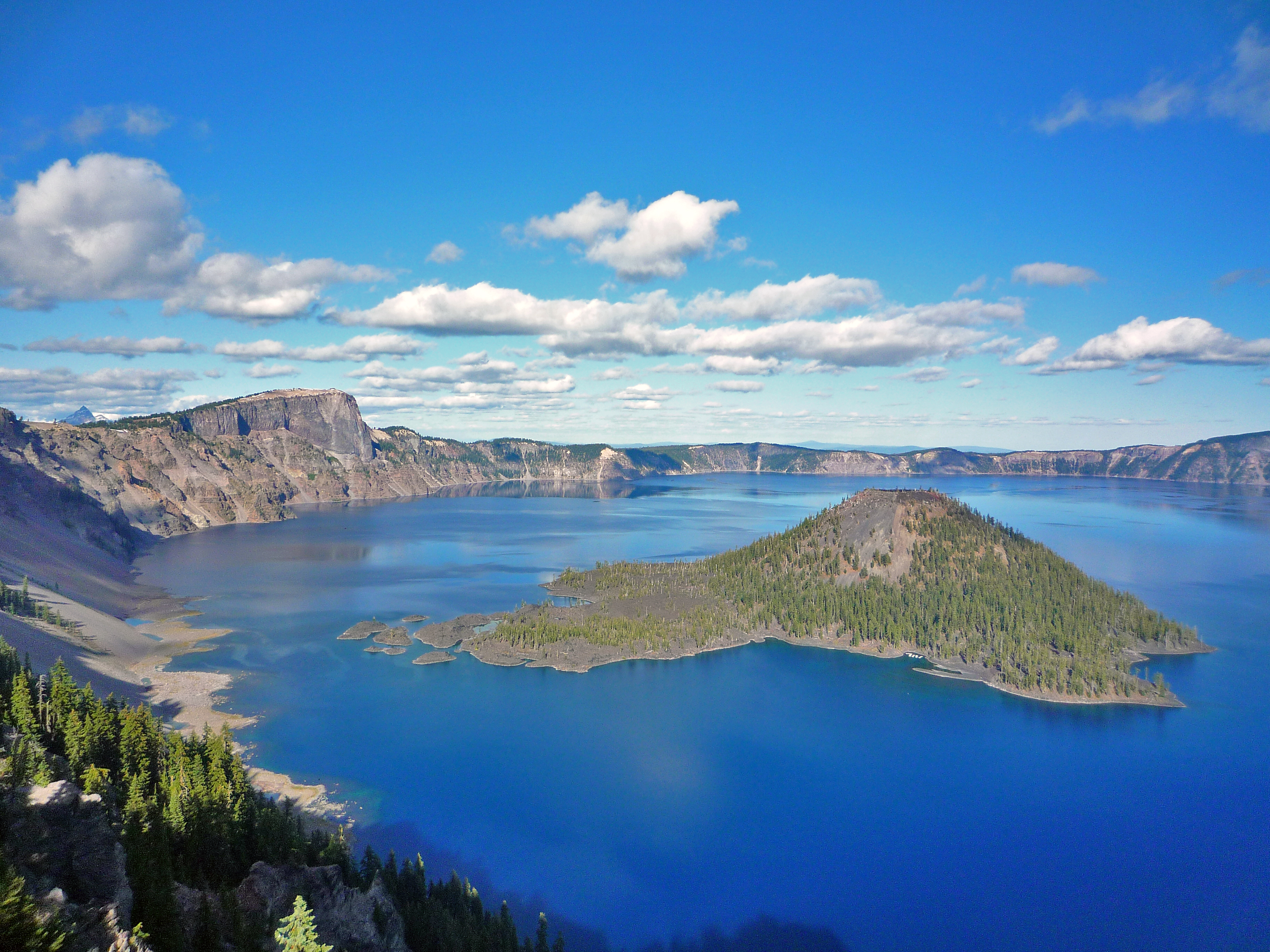
Crater Lake National Park
National Park
Crater Lake inspires awe. Native Americans witnessed its formation 7,700 years ago, when a violent eruption triggered the collapse of a tall peak. Scientists marvel at its purity—fed by rain and snow,...
18 mi from route
~45 min detour
$30
near mile 316.3
Park Closure: Cleetwood Cove Trail is CLOSED for Rehabilitation
Park Closure: North Entrance Road and Rim Drive are CLOSED for the Season
Park data from the National Park Service API. Alerts update every 2 hours.
More Details
What kind of drive is this?
Expect a turn-heavy local drive for this 436.8-mile trip, with only 9% of the route on highways. This means you'll be navigating more local roads, which can offer a different perspective but also require more attention. The longest uninterrupted stretch you'll encounter is 123.3 miles on the Central Oregon Highway. While the entire drive is estimated at 10 hours and 37 minutes, the nature of these local roads suggests a pace that is more about the journey than covering ground quickly. Be prepared for a driving experience that feels less like a freeway cruise and more like exploring the local landscape.
Only 9% highway — the rest is turn-by-turn surface driving.
55 navigation steps total — most of the decisions cluster near the start and finish.
Longest single stretch: 123.3 mi on Central Oregon Highway.
How Hard Is This Drive?
6/10
Expect a hands-on drive with frequent turns and local roads rather than long highway stretches. You will hit about 33 points where you need to pay attention to lane position or signs. The trickiest moment comes early in the drive near West Idaho Avenue.
Driving Effort6/10
Moderate - straightforward overall, but long enough or busy enough to require pacing
Balances navigation complexity with total wheel time.
This drive requires moderate attention. Across 436.8 miles you will encounter 33 spots where lane choice or exit timing matters. Not difficult for experienced highway drivers, but worth previewing the tricky sections before you go.
Where does it get tricky?
The main spots that need attention: near the start (West Idaho Avenue): Navigation decision point; at 4.8 miles (US 20; US 26 / Central Oregon Highway): Roundabout - know your exit number before entering; at 129.6 miles (West D Street): Navigation decision point.
Elevation Profile
High-altitude sections with notable climbs
5,086 ft940 ft
Total Climb
4,201 ft
Total Descent
5,415 ft
Highest Point
5,086 ft
~280.8 mi in
Elevation Range
4,146 ft
Notable High Points
4,716 ft at ~187.2 miles+396 ft prominence
5,086 ft at ~280.8 miles+525 ft prominence
5,032 ft at ~374.4 miles+872 ft prominence
Towns Mentioned on Route Signs
Based on OSRM destination-sign hints, not a full list of every settlement the road passes.
On the drive from Ontario, OR to Grants Pass, OR, road signs begin pointing toward Crater Lake along the way.
Ontario is a city of 12,000 people (2020) in Eastern Oregon along the Snake River at the Idaho border. The city is the largest community in the region of far eastern Oregon, also known as the Western Treasure Valley.
Top landmarks
•Ontario Depot — former railway station in Ontario, Oregon, United States
Grants Pass is a city in Southern Oregon.
The slogan for the city is “It’s the Climate,” and nothing could fit the town better. Grants Pass has been known in the winter to receive sun, rain, and snow all on the same day! Its climate is very similar to that of nearby Medford in Jackson County.
One of Grants Pass’ greatest achievements is being one of the most caffeinated cities in Southern Oregon. It is home to the originators of Dutch Bros. and stickers adorn almost every car’s bumper or window.
Moderate complexity with 3 natural rest stops along the way.
Solo Traveler
10h 37m drive, plan rest stops for pacing.
Scenic Drive
Mostly surface roads route profile with national parks nearby.
Frequently Asked Questions
The longest stretch is about 123.3 miles on Central Oregon Highway. The full list of main roads is in the Roads section above.
Yes — a 2-day pace is more comfortable than one long haul. A sensible stopping point is after roughly 218 miles on day one.
Yes — we found about 6 rest areas or service plazas within a short detour of the route (from OpenStreetMap). See the Rest Stops tab under Nearby Places for locations and mile markers. Plan to stretch, use the bathroom, and top off fluids every 2–3 hours on longer drives.
It helps. This route has a higher-than-average number of complex decision points, which get harder in the dark. If the last hour of the trip is on surface roads or mountain grades, aim to arrive at Grants Pass, OR before sunset when you can. Check the Trip Plan for departure windows that land you in daylight.
Only with planning. This is a long drive for kids — consider splitting it into two days rather than pushing through. Plan at least 3 meaningful breaks. There are 6 rest areas along the route for bathroom stops.
The main spots that need attention: near the start (West Idaho Avenue): Navigation decision point; at 4.8 miles (US 20; US 26 / Central Oregon Highway): Roundabout - know your exit number before entering; at 129.6 miles (West D Street): Navigation decision point.
Yes — Crater Lake National Park. See the National Parks section for detour distances and tips on detours.
Not recommended in a single day. At 10.6 hours each way, a round trip means 21.2 hours of driving — that is an unsafe level of fatigue for most drivers. Plan at least one night at Grants Pass, OR before the return drive.