Traveling from Grants Pass to Seaside covers 316.5 miles and typically takes about 6 hours and 28 minutes of drive time. Because this route relies on local streets like Southwest 4th Street and Northwest Savage Street rather than major interstates, it is best approached as a full-day commitment. You should budget approximately $63 for fuel to complete the trip. While both cities sit within the Pacific Coast region, the transit between them requires navigating a turn-heavy path through local infrastructure. It is a manageable single-day trek if you start early, but be prepared for a steady pace rather than a high-speed cruise.
Trip Pace
Same-day drive is realistic
A same-day return is possible, but it will make for a full day on the road.
Break Rhythm
1 planned break
Plan on a short reset every 3 to 4 hours to stay fresh behind the wheel.
Midpoint
158.2 miles from Grants Pass, OR
A natural place for your longest stop of the day
, about 3h 8m into the drive
.
Main Roads
Road
Distance
Duration
OR 99
233.7 mi
4h 33m
Sunset Highway
34.7 mi
43m
Northwest Sunset Highway
33.2 mi
45m
Beaverton-Tigard Freeway
6.7 mi
9m
South Roosevelt Drive
3.8 mi
7m
OR 217
0.9 mi
2m
Northeast 7th Street
0.8 mi
1m
Southwest 4th Street
0.7 mi
1m
Longest stretch:
OR 99
— 233.7 mi, about 4h 33m
Turn-by-Turn Driving Directions
Step-by-step road directions between Grants Pass, OR and Seaside, OR.
1
Start on Southwest H Street
196 ft·16 sec·Southwest H Street
2
Turn left onto Southwest 4th Street
0.7 mi·1 min·Southwest 4th Street
3
Continue on Northwest Washington Boulevard
0.3 mi·41 sec·Northwest Washington Boulevard
4
Turn right onto Northwest Savage Street
0.1 mi·21 sec·Northwest Savage Street
5
Continue on Northeast Savage Street
504 ft·21 sec·Northeast Savage Street
6
Turn left onto OR 99
0.8 mi·1 min·Northeast 7th Street
7
Take the exit onto OR 99
234 mi·4 hr 33 min·OR 99
Use the straight lane.
8
Take the exit
0.8 mi·1 min
Exit 292AToward OR 217: Tigard, BeavertonUse the straight / slight right lanes.
9
Merge onto OR 217
6.7 mi·9 min·Beaverton-Tigard Freeway
Use the straight / slight right lanes.
10
Take the exit onto OR 217
0.9 mi·2 min·OR 217
Toward US 26 West
11
Merge onto US 26
33 mi·45 min·Northwest Sunset Highway
Use the straight / slight right lanes.
12
Continue on US 26
35 mi·43 min·Sunset Highway
13
Take the exit
0.3 mi·26 sec
Toward US 101 North: Seaside, Astoria
14
Merge onto US 101
0.2 mi·13 sec·Oregon Coast Highway
15
Continue on US 101
3.8 mi·7 min·South Roosevelt Drive
Use the straight / right lanes.
16
Turn left onto Broadway Street
514 ft·10 sec·Broadway Street
17
Arrive at destination
Broadway Street
Trip Plan
Since the journey spans over six hours, plan to make at least one dedicated stop to stretch your legs and refresh. Aim to depart Grants Pass early in the morning to ensure you reach Seaside well before sunset, as navigating local turns is significantly easier in daylight. Keep a close eye on your fuel gauge, as the $63 estimate is a baseline that can fluctuate depending on your vehicle's efficiency and the specific local stations you choose. Because the route is composed entirely of local roads, use a reliable GPS to stay on track through the turns on Northwest Savage Street and surrounding intersections. This flexibility allows you to adjust your pace, but prioritize steady progress to avoid unexpected evening fatigue.
Morning Departure
Start early — leave by 6-7 AM to arrive at a reasonable hour.
Evening Departure
This is a long drive — plan for a morning departure or consider splitting it into two days.
You can normally do this drive in one day.
Plan roughly 1 meaningful break for fuel, food, and rest.
The halfway point lands around 158.2 miles from Grants Pass, OR, or about 3h 8m into the drive.
The longest continuous stretch on this route runs about 233.7 miles.
This is a comfortable same-day trip.
Departure
Before you leave
Start with fuel, water, and navigation already sorted so the first hour feels easy.
First stop
Around 70 miles or 1h 24m in
Use this first pause for coffee, a restroom break, and a quick traffic check ahead.
Halfway reset
Around 158.2 miles or 3h 8m in
This is the best place for your longest stop, a real meal, and a full fuel check.
Final approach
Final hour starts around 5h 12m
Traffic, exits, and arrival timing usually matter more near Seaside, OR than in the middle of the route.
Before You Leave
+
Open the route before leaving Grants Pass, OR so your first major turns are already loaded.
+
Leave with enough water and a charging cable within reach, not packed away.
+
Check your fuel range against the first long segment, especially if you are starting outside city service areas.
Day 1
Settle into the route from Grants Pass, OR
This is one driving day of about 316.5 miles and 6h 28m.
Your first comfortable stop window is around 70 miles from Grants Pass, OR.
This route can stay practical as a one-day drive if traffic stays reasonable.
Plan about 1 real break rather than only quick fuel stops.
The longest stretch is on OR 99 for about 233.7 miles.
Where to Stop
Rest stops, refuel points, and overnight suggestions along this route.
Place data sourced from public business listings. Hours and availability may vary.
Heads-up: tricky spots
5 of 11
5 decision points cluster between mile 1 and 244.2 — GPS handles the exact turns, but know they're coming. Your lane choice matters more than the turn itself.
5
1 mi into trip|~2m in|Northwest Savage Street
Turn right onto Northwest Savage Street
Navigation decision point
5
2 mi into trip|~5m in|OR 99
Take the exit onto OR 99
Exit ramp - move to the correct lane early. Lane positioning matters here
Use the straight lane.
8
235.7 mi into trip|~4h 38m in
Take the exit toward OR 217: Tigard, Beaverton
Exit ramp - move to the correct lane early. Lane positioning matters here. Multiple destination signs - pick the right one
Use the straight / slight right lanes.
Exit 292A
Toward OR 217: Tigard, Beaverton
5
236.5 mi into trip|~4h 40m in|OR 217 / Beaverton-Tigard Freeway
Merge onto OR 217 / Beaverton-Tigard Freeway
Merge point - match speed before joining. Lane positioning matters here
Use the straight / slight right lanes.
5
244.2 mi into trip|~4h 51m in|US 26 / Northwest Sunset Highway
Merge onto US 26 / Northwest Sunset Highway
Merge point - match speed before joining. Lane positioning matters here
Use the straight / slight right lanes.
Fuel & Cost
Regular Gas
$56.09 one way
$112.17 round trip
$4.50/gal25.4 MPG avg111 kg CO2
Fuel Type
$/gal
One Way
Round Trip
midgrade
$4.82
$60.06
$120.12
premium
$5.04
$62.83
$125.65
diesel
$4.80
$59.76
$119.52
No toll roads detected on this route.
Estimated Trip Cost (one way, 1 person)
Fuel
$56
Meals
$25–$50
Total
$81–$106
Rough estimate based on US averages. Hotel $80–$140/night, meals $25–$50/day.
Estimated CO2 emission: 110.7 kg one way.
Prices: EIA weekly data, 2026-07-13.
Driving Electric?
About $33 in charging
· 1 stop
· 67% less CO2
Vehicle Type
kWh
Stops
DC Fast
Home Charge
Average EV
95
1
$33.23
$15.19
Efficient EV
79.1
0
$27.69
$12.66
EV Truck/SUV
126.6
1
$44.31
$20.26
Gas CO2
111 kg
EV CO2
37 kg (67% less)
Plan for 1 charging stop. A 30-minute DC fast charge mid-route should be enough to complete the trip comfortably.
DC fast charging avg $0.35/kWh. Home charging avg $0.16/kWh. US grid CO2: 0.39 kg/kWh.
Travel Intel
Current conditions at both ends of the drive.
Forecast as of Jul 17, 2026
Origin
Grants Pass, OR
Evening
in Grants Pass on Saturday
Local time
6:30 PM
PDT
Current temp
90°F
Patchy Smoke
NW 2 to 12 mph0% chanceLive forecast
Red Flag Warning
Red Flag Warning issued July 17 at 10:23AM PDT until July 18 at 10:00PM PDT by NWS Pendleton OR
Red Flag Warning
Red Flag Warning issued July 17 at 1:44AM PDT until July 17 at 8:00PM PDT by NWS Medford OR
Destination
Seaside, OR
Evening
in Seaside on Saturday
Local time
6:30 PM
PDT
Current temp
64°F
Mostly Sunny
WSW 7 mph1% chanceLive forecast
Red Flag Warning
Red Flag Warning issued July 17 at 10:23AM PDT until July 18 at 10:00PM PDT by NWS Pendleton OR
Red Flag Warning
Red Flag Warning issued July 17 at 1:44AM PDT until July 17 at 8:00PM PDT by NWS Medford OR
90°F
Salem, OR
158 mi in
Seasonal Notes
Summer travel usually means heavier construction, hotter rest stops, and busier weekend traffic around major cities.
Winter travel shortens daylight, so a route that looks manageable on paper can feel much longer after dark.
Holiday weekends tend to make both departure and arrival windows slower than the raw route time suggests.
Time zone
Same local time
Origin and destination are on the same clock, so arrival timing is easier to judge at a glance.
Temperature spread
26 degrees cooler at arrival
A meaningful temperature swing is a good cue to rethink layers, water, and how soon you want to arrive.
Road read
6h 28m on the road
Start early — leave by 6-7 AM to arrive at a reasonable hour.
Weather data from the National Weather Service. Conditions may change; check closer to your travel date.
National Parks Near This Route
Worth a detour if your schedule allows.
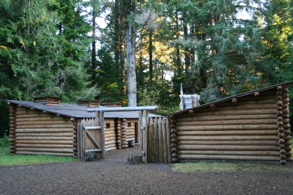
Lewis and Clark National Historical Park
National Historical Park
Explore the timeless rainforests and majestic coastal vistas. Discover the rich heritage of the native people. Unfold the dramatic stories of America's most famous explorers. The park encompasses site...
15 mi from route
~38 min detour
$10
near mile 316.5
Park data from the National Park Service API. Alerts update every 2 hours.
More Details
What kind of drive is this?
Expect a technical and engaging experience behind the wheel, as this route is defined by its turn-heavy local nature. With a 0% highway share, you will spend the entire 316.5 miles navigating local roads such as Northwest Washington Boulevard. This is not a route for cruising on autopilot; it demands your full attention as you transition through various local intersections. The character of the drive remains consistent, favoring precision over speed. You won't find long, monotonous stretches here, making it a unique alternative to standard interstate travel.
76% highway — fuel and pacing are the main things to plan.
17 navigation steps total — most of the decisions cluster near the start and finish.
Longest single stretch: 233.7 mi on OR 99.
How Hard Is This Drive?
5/10
This is a straightforward highway drive that stays mostly on OR 99 and Sunset Highway. You will hit about 11 points where you need to pay attention to lane position or signs. The trickiest moment comes around 1 miles in near Northwest Savage Street.
Driving Effort5/10
Moderate - straightforward overall, but long enough or busy enough to require pacing
Balances navigation complexity with total wheel time.
This drive requires moderate attention. Across 316.5 miles you will encounter 11 spots where lane choice or exit timing matters. Not difficult for experienced highway drivers, but worth previewing the tricky sections before you go.
Where does it get tricky?
The main spots that need attention: at 1 miles (Northwest Savage Street): Navigation decision point; at 2 miles (OR 99): Exit ramp - move to the correct lane early. Lane positioning matters here; at 235.7 miles: Exit ramp - move to the correct lane early. Lane positioning matters here. Multiple destination signs - pick the right one.
Elevation Profile
Gently rolling terrain
1,565 ft18 ft
Total Climb
1,824 ft
Total Descent
2,745 ft
Highest Point
1,565 ft
~22.6 mi in
Elevation Range
1,547 ft
Notable High Points
1,565 ft at ~22.6 miles+625 ft prominence
1,093 ft at ~271.3 miles+581 ft prominence
Towns Mentioned on Route Signs
Based on OSRM destination-sign hints, not a full list of every settlement the road passes.
On the drive from Grants Pass, OR to Seaside, OR, road signs begin pointing toward Beaverton along the way.
Grants Pass is a city in Southern Oregon.
The slogan for the city is “It’s the Climate,” and nothing could fit the town better. Grants Pass has been known in the winter to receive sun, rain, and snow all on the same day! Its climate is very similar to that of nearby Medford in Jackson County.
One of Grants Pass’ greatest achievements is being one of the most caffeinated cities in Southern Oregon. It is home to the originators of Dutch Bros. and stickers adorn almost every car’s bumper or window.
Seaside is a city on the Northern Oregon Coast. Seaside is one of the most popular beach resorts on the Oregon Coast, helped largely by easy access from Portland.
Doable as a same-day drive at 6h 28m. Total distance: 316.5 miles.
Family Friendly
Moderate complexity with 1 natural rest stops along the way.
Solo Traveler
6h 28m drive, plan rest stops for pacing.
First-Time Driver
Mostly highway driving (76%). Some complex stretches to watch for.
Frequently Asked Questions
The longest stretch is about 233.7 miles on OR 99. The full list of main roads is in the Roads section above.
Yes — we found about 29 rest areas or service plazas within a short detour of the route (from OpenStreetMap). See the Rest Stops tab under Nearby Places for locations and mile markers. Plan to stretch, use the bathroom, and top off fluids every 2–3 hours on longer drives.
It helps. This is a long drive, so arriving tired and in the dark compounds. If the last hour of the trip is on surface roads or mountain grades, aim to arrive at Seaside, OR before sunset when you can. Check the Trip Plan for departure windows that land you in daylight.
Only with planning. This is a long drive for kids — consider splitting it into two days rather than pushing through. Plan at least 1 meaningful breaks. There are 29 rest areas along the route for bathroom stops.
The main spots that need attention: at 1 miles (Northwest Savage Street): Navigation decision point; at 2 miles (OR 99): Exit ramp - move to the correct lane early. Lane positioning matters here; at 235.7 miles: Exit ramp - move to the correct lane early. Lane positioning matters here. Multiple destination signs - pick the right one.
Yes — Lewis and Clark National Historical Park. See the National Parks section for detour distances and tips on detours.
Not recommended in a single day. At 6.5 hours each way, a round trip means 13.0 hours of driving — that is an unsafe level of fatigue for most drivers. Plan at least one night at Seaside, OR before the return drive.