If you are planning a journey from Olive Branch to Rosedale, you can expect a manageable 121.9-mile trip that takes approximately 2 hours and 34 minutes. This drive is ideal for a one-day excursion, allowing you to reach your destination without the need for an overnight stay. Your travel path primarily utilizes US 61, Mississippi Highway 1, and segments of I-69. With an estimated fuel cost of $19, the trip is budget-friendly and straightforward for those navigating within the Southeast. Since both cities are located in Mississippi, you will remain within the same region for the duration of your travel. It is a practical, no-nonsense route that gets you from point A to point B efficiently.
Trip Pace
Same-day drive is realistic
A same-day return is realistic if you keep stops short.
Break Rhythm
1 planned break
A short stop every 2 to 3 hours is enough for this drive.
Midpoint
61 miles from Olive Branch, MS
A natural place for your longest stop of the day
, about 1h 13m into the drive
.
Main Roads
Road
Distance
Duration
US 61
67.8 mi
1h 18m
Mississippi Highway 1
15.4 mi
22m
I 69
10.6 mi
11m
I 269
9.6 mi
10m
East Main Street
6.6 mi
11m
Cockrum Road
6.2 mi
11m
MS 304
2.8 mi
2m
Prospect Avenue
1 mi
1m
Longest stretch:
US 61
— 67.8 mi, about 1h 18m
Turn-by-Turn Driving Directions
Step-by-step road directions between Olive Branch, MS and Rosedale, MS.
1
Start on Goodman Road
260 ft·12 sec·Goodman Road
2
Turn left onto MS 305
6.2 mi·11 min·Cockrum Road
3
Take the ramp
0.3 mi·41 sec
Toward Tunica
4
Merge onto I 269; MS 304
9.6 mi·10 min·I 269; MS 304
5
Continue on I 69; MS 304
11 mi·11 min·I 69; MS 304
6
Keep slight left at fork onto MS 304
2.8 mi·2 min·MS 304
7
Keep slight left at fork
0.8 mi·1 min
Toward US 61 South: Tunica
8
Merge onto US 61
68 mi·1 hr 18 min·US 61
9
Turn right onto MS 444
6.6 mi·11 min·East Main Street
10
At end of road, turn left onto MS 1
8.7 mi·12 min·Mississippi Highway 1
11
Continue on MS 1
1.0 mi·1 min·Prospect Avenue
12
Continue on MS 1
6.7 mi·9 min·Mississippi Highway 1
13
Continue on MS 1
0.8 mi·1 min·Main Street
14
Arrive at destination
MS 1
Trip Plan
To make the most of your 121.9-mile trek, consider leaving early in the morning to avoid midday traffic fluctuations. Since the trip takes roughly 2.5 hours, you have the flexibility to complete the entire route in one go or take advantage of the one planned stop to stretch your legs. Keep an eye on your fuel gauge, as the $19 estimate is a good baseline, but it is always wise to top off before hitting the longer 67.8-mile stretch on US 61. Because this is a shorter, high-speed route, use your single stop strategically to ensure you remain alert behind the wheel. Given the reliance on major highways, check for any local road maintenance updates on US 61 before you depart to ensure your commute remains seamless.
Morning Departure
Leave by 9 AM and you'll arrive before lunch.
Evening Departure
Even a 4 PM departure gets you there before dark in summer.
You can normally do this drive in one day.
Plan roughly 1 meaningful break for fuel, food, and rest.
The halfway point lands around 61 miles from Olive Branch, MS, or about 1h 13m into the drive.
The longest continuous stretch on this route runs about 67.8 miles.
This is a comfortable same-day trip.
Departure
Before you leave
Start with fuel, water, and navigation already sorted so the first hour feels easy.
First stop
Around 27 miles or 33m in
Use this first pause for coffee, a restroom break, and a quick traffic check ahead.
Halfway reset
Around 61 miles or 1h 13m in
This is the best place for your longest stop, a real meal, and a full fuel check.
Final approach
Final hour starts around 2h
Traffic, exits, and arrival timing usually matter more near Rosedale, MS than in the middle of the route.
Before You Leave
+
Open the route before leaving Olive Branch, MS so your first major turns are already loaded.
+
Leave with enough water and a charging cable within reach, not packed away.
+
Check your fuel range against the first long segment, especially if you are starting outside city service areas.
Day 1
Settle into the route from Olive Branch, MS
This is one driving day of about 121.9 miles and 2h 34m.
Your first comfortable stop window is around 27 miles from Olive Branch, MS.
This route can stay practical as a one-day drive if traffic stays reasonable.
Plan about 1 real break rather than only quick fuel stops.
The longest stretch is on US 61 for about 67.8 miles.
Where to Stop
Rest stops, refuel points, and overnight suggestions along this route.
Place data sourced from public business listings. Hours and availability may vary.
Heads-up: tricky spots
5 of 7
5 decision points cluster between mile 0 and 104.8 — GPS handles the exact turns, but know they're coming. Your lane choice matters more than the turn itself.
4
0 mi into trip|~0m in|MS 305 / Cockrum Road
Turn left onto MS 305 / Cockrum Road
Navigation decision point
4
6.3 mi into trip|~11m in
Take the ramp toward Tunica
Navigation decision point
Toward Tunica
4
26.8 mi into trip|~33m in|MS 304
Keep slight left at fork onto MS 304
Highway fork - watch signs carefully
5
29.6 mi into trip|~36m in
Keep slight left at fork toward US 61 South: Tunica
Highway fork - watch signs carefully
Toward US 61 South: Tunica
5
104.8 mi into trip|~2h 8m in|MS 1 / Mississippi Highway 1
At end of road, turn left onto MS 1 / Mississippi Highway 1
Navigation decision point
Fuel & Cost
Regular Gas
$18.41 one way
$36.82 round trip
$3.84/gal25.4 MPG avg43 kg CO2
Fuel Type
$/gal
One Way
Round Trip
midgrade
$4.21
$20.21
$40.42
premium
$4.56
$21.88
$43.76
diesel
$5.61
$26.91
$53.83
No toll roads detected on this route.
Estimated Trip Cost (one way, 1 person)
Fuel
$18
Meals
$25–$50
Total
$43–$68
Rough estimate based on US averages. Hotel $80–$140/night, meals $25–$50/day.
Estimated CO2 emission: 42.7 kg one way.
Prices: EIA weekly data, 2026-04-13.
EV Charging Along Route
2 DC fast chargers
· Coverage: good
GATEWAY TIRE STATION 1
Hernando, MS
ChargePoint Network
1 DCFC
GATEWAY TIRE STATION 2- NACS
Hernando, MS
ChargePoint Network
1 DCFC
ChargePoint Network: 2
Station data from NREL Alternative Fuel Stations database.
Driving Electric?
About $13 in charging
· 0 stops
· 67% less CO2
Vehicle Type
kWh
Stops
DC Fast
Home Charge
Average EV
36.6
0
$12.80
$5.85
Efficient EV
30.5
0
$10.67
$4.88
EV Truck/SUV
48.8
0
$17.07
$7.80
Gas CO2
43 kg
EV CO2
14 kg (67% less)
This trip is well within single-charge range for most EVs. No charging stops needed if you start fully charged.
DC fast charging avg $0.35/kWh. Home charging avg $0.16/kWh. US grid CO2: 0.39 kg/kWh.
Travel Intel
Current conditions at both ends of the drive.
Forecast as of Apr 21, 2026
Origin
Olive Branch, MS
Late night
in Olive Branch on Tuesday
Local time
3:47 AM
CDT
Current temp
52°F
Mostly Clear
S 5 mph0% chanceLive forecast
Destination
Rosedale, MS
Late night
in Rosedale on Tuesday
Local time
3:47 AM
CDT
Current temp
53°F
Mostly Clear
S 0 to 5 mph0% chanceLive forecast
Seasonal Notes
Summer travel usually means heavier construction, hotter rest stops, and busier weekend traffic around major cities.
Winter travel shortens daylight, so a route that looks manageable on paper can feel much longer after dark.
Holiday weekends tend to make both departure and arrival windows slower than the raw route time suggests.
Time zone
Same local time
Origin and destination are on the same clock, so arrival timing is easier to judge at a glance.
Temperature spread
1 degrees warmer at arrival
A meaningful temperature swing is a good cue to rethink layers, water, and how soon you want to arrive.
Road read
2h 34m on the road
The weather snapshot is not static. If you are leaving later, give both cities one more quick forecast check before departure.
Weather data from the National Weather Service. Conditions may change; check closer to your travel date.
National Parks Near This Route
Worth a detour if your schedule allows.
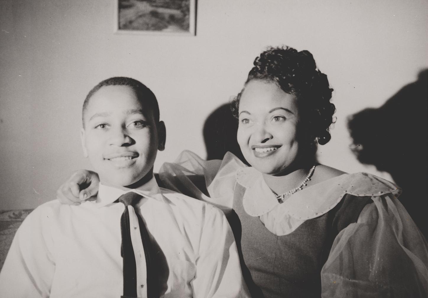
Emmett Till and Mamie Till-Mobley National Monument
National Monument
In 1955, 14-year-old Emmett Till traveled to Money, Mississippi, to visit relatives. He was kidnapped, tortured, and murdered after reportedly whistling at a white woman. His mother, Mamie Till-Mobley...
18 mi from route
~45 min detour
Free
near mile 84.1
Park data from the National Park Service API. Alerts update every 2 hours.
More Details
What kind of drive is this?
This highway-focused drive is characterized by its high percentage of open road, with 87% of the journey consisting of highway travel. You will experience a significant stretch of 67.8 miles on US 61, which serves as the core of your trip. The route offers a consistent pace, transitioning from the interstate connectivity of I-69 into the regional flow of Mississippi Highway 1. Behind the wheel, you can anticipate a steady, highway-dominated experience rather than a technical or winding backcountry drive. The transition between these road types keeps the drive moving at a reliable clip, making it a predictable experience for any driver.
87% highway — fuel and pacing are the main things to plan.
14 navigation steps total — most of the decisions cluster near the start and finish.
Longest single stretch: 67.8 mi on US 61.
How Hard Is This Drive?
4/10
This is a straightforward highway drive that stays mostly on US 61 and Mississippi Highway 1. There are only a few real navigation decisions along the way. The trickiest moment comes early in the drive near MS 305 / Cockrum Road.
Driving Effort4/10
Easy - simple navigation with a manageable amount of wheel time
Balances navigation complexity with total wheel time.
This is a straightforward 2h 34m drive. You will face about 7 decision points, but nothing that requires special attention if you follow navigation.
Where does it get tricky?
The main spots that need attention: near the start (MS 305 / Cockrum Road): Navigation decision point; at 6.3 miles: Navigation decision point; at 26.8 miles (MS 304): Highway fork - watch signs carefully.
Elevation Profile
Mostly flat terrain
384 ft146 ft
Total Climb
23 ft
Total Descent
262 ft
Highest Point
384 ft
Elevation Range
239 ft
Towns Mentioned on Route Signs
Based on OSRM destination-sign hints, not a full list of every settlement the road passes.
On the drive from Olive Branch, MS to Rosedale, MS, road signs begin pointing toward Tunica along the way.
Tunica
6.3 mi in|~11m
Who Is This Route For?
Weekend Trip
Doable as a same-day drive at 2h 34m. Total distance: 121.9 miles.
Family Friendly
Moderate complexity with 1 natural rest stops along the way.
The longest stretch is about 67.8 miles on US 61. The full list of main roads is in the Roads section above.
Yes, with realistic expectations. Build in a stop roughly every 2 hours, have snacks and activities ready, and check the Nearby Places tabs for kid-friendly stops along the way.
The main spots that need attention: near the start (MS 305 / Cockrum Road): Navigation decision point; at 6.3 miles: Navigation decision point; at 26.8 miles (MS 304): Highway fork - watch signs carefully.
Yes — Emmett Till and Mamie Till-Mobley National Monument. See the National Parks section for detour distances and tips on detours.
Yes. A round trip is manageable in a single day if you plan a break at Rosedale, MS before heading back.