Origin
Moriarty, NM
Evening in Moriarty on Saturday
Local time
8:52 PM
MDT
Current temp
39°F
Unavailable
Live forecast
Compiled and reviewed by the US Trip Planner planning team at COD Solutions Oy · Last reviewed Apr 18, 2026 · Editorial standards
Drive Time
3h 46m
Distance
168.3 mi
271 km
Drive Score
9/10
Great drive
Same Day?
Yes, doable
Fuel Cost
$25
one way
EV Charging
Unknown
Estimated drive times based on typical traffic patterns. Actual times may vary with weather, construction, and real-time conditions.

Moriarty, NM
Israyosoy S.

Alamogordo, NM
Wikimedia Commons
Moriarty to Alamogordo is 168.3 miles and takes about 3h 46m via Main Street and NM 42, with a fuel budget near $25 and enough daylight to finish in a day. This trip stays within New Mexico, traversing the Desert Southwest from start to finish. Expect a drive with frequent turns, suggesting you'll be navigating local roads and smaller highways more than interstates. With only one recommended stop and a drive time under four hours, this route is ideal for a single-day excursion, allowing for flexibility in your schedule.
Trip Pace
Same-day drive is realistic
A same-day return is realistic if you keep stops short.
Break Rhythm
1 planned break
A short stop every 2 to 3 hours is enough for this drive.
Midpoint
84.1 miles from Moriarty, NM
A natural place for your longest stop of the day , about 1h 57m into the drive .
| Road | Distance | Duration |
|---|---|---|
| Main Street | 47.3 mi | 1h 6m |
| Central Avenue | 43.8 mi | 51m |
| NM 42 | 35.5 mi | 48m |
| State Road 41 | 26.5 mi | 37m |
| Saint Francis Drive | 9.8 mi | 12m |
| North White Sands Boulevard | 3.1 mi | 5m |
| US 60 | 1.9 mi | 3m |
| Howard Cavazos Boulevard South | 0.3 mi | <1m |
Step-by-step road directions between Moriarty, NM and Alamogordo, NM.
Start on 4th Street
Turn right onto Center Avenue
Turn left onto NM 41
Continue on NM 41
At end of road, turn left onto US 60
Turn right onto NM 42
At end of road, turn right onto US 54
Continue on US 54
Take the ramp onto US 54
Turn straight onto North White Sands Boulevard
Arrive at destination
Given the 3h 46m duration, leaving Moriarty in the morning will give you ample time to reach Alamogordo before evening. Plan for one stop to break up the drive, perhaps around the halfway point or where a good rest area is available. Keep an eye on your fuel gauge, as the $25 budget suggests this isn't a high-consumption route, but it's always wise to top off before heading into longer stretches. Since this is a single-day trip, you have the flexibility to depart later if needed, but be aware of the longest stretch of 47.3 miles on Main Street – ensure you're comfortable with that segment before you begin.
Morning Departure
An early start around 7-8 AM gets you there with plenty of daylight left.
Evening Departure
A late afternoon start means arriving after dark. Morning is better.
This is a comfortable same-day trip.
Departure
Before you leave
Start with fuel, water, and navigation already sorted so the first hour feels easy.
First stop
Around 37 miles or 52m in
Use this first pause for coffee, a restroom break, and a quick traffic check ahead.
Halfway reset
Around 84.1 miles or 1h 57m in
This is the best place for your longest stop, a real meal, and a full fuel check.
Final approach
Final hour starts around 3h 7m
Traffic, exits, and arrival timing usually matter more near Alamogordo, NM than in the middle of the route.
Open the route before leaving Moriarty, NM so your first major turns are already loaded.
Leave with enough water and a charging cable within reach, not packed away.
Check your fuel range against the first long segment, especially if you are starting outside city service areas.
Day 1
Settle into the route from Moriarty, NM
This is one driving day of about 168.3 miles and 3h 46m.
Rest stops, refuel points, and overnight suggestions along this route.

Mid-route town
Meal stop
84 mi into the route
Best for: Lunch, fuel, and a longer reset
This sits close to the middle of the route, so it works well for the longest stop of the day.
A short stop after about 37 miles helps settle the day before fatigue starts building.
The midpoint is around 84.1 miles from Moriarty, NM, which is a good place for a longer meal and fuel stop.
These stop ideas are pacing suggestions — the exact town or exit can change with traffic, hotel plans, and fuel range.
5 decision points cluster between mile 0 and 64.3 — GPS handles the exact turns, but know they're coming. Your lane choice matters more than the turn itself.
Turn right onto Center Avenue
Navigation decision point
Turn left onto NM 41 / Howard Cavazos Boulevard South
Navigation decision point
At end of road, turn left onto US 60
Navigation decision point
Turn right onto NM 42
Navigation decision point
At end of road, turn right onto US 54 / Main Street
Navigation decision point
Regular Gas
$25.42 one way
$50.83 round trip
| Fuel Type | $/gal | One Way | Round Trip |
|---|---|---|---|
| midgrade | $4.21 | $27.90 | $55.80 |
| premium | $4.56 | $30.21 | $60.42 |
| diesel | $5.61 | $37.16 | $74.32 |
No toll roads detected on this route.
Estimated Trip Cost (one way, 1 person)
Fuel
$25
Meals
$25–$50
Total
$50–$75
Rough estimate based on US averages. Hotel $80–$140/night, meals $25–$50/day.
Estimated CO2 emission: 58.9 kg one way. Prices: EIA weekly data, 2026-04-13.
Driving Electric?
About $18 in charging · 0 stops · 66% less CO2
| Vehicle Type | kWh | Stops | DC Fast | Home Charge |
|---|---|---|---|---|
| Average EV | 50.5 | 0 | $17.67 | $8.08 |
| Efficient EV | 42.1 | 0 | $14.73 | $6.73 |
| EV Truck/SUV | 67.3 | 0 | $23.56 | $10.77 |
Gas CO2
59 kg
EV CO2
20 kg (66% less)
This trip is well within single-charge range for most EVs. No charging stops needed if you start fully charged.
DC fast charging avg $0.35/kWh. Home charging avg $0.16/kWh. US grid CO2: 0.39 kg/kWh.
Current conditions at both ends of the drive.
Origin
Evening in Moriarty on Saturday
Local time
8:52 PM
MDT
Current temp
39°F
Unavailable
Destination
Evening in Alamogordo on Saturday
Local time
8:52 PM
MDT
Current temp
52°F
Unavailable
Seasonal Notes
Summer travel usually means heavier construction, hotter rest stops, and busier weekend traffic around major cities.
Winter travel shortens daylight, so a route that looks manageable on paper can feel much longer after dark.
Holiday weekends tend to make both departure and arrival windows slower than the raw route time suggests.
Time zone
Origin and destination are on the same clock, so arrival timing is easier to judge at a glance.
Temperature spread
A meaningful temperature swing is a good cue to rethink layers, water, and how soon you want to arrive.
Road read
Use the two city cards together: check the sky where you start, then compare it with the local time and temperature at arrival.
Weather data from the National Weather Service. Conditions may change; check closer to your travel date.
Worth a detour if your schedule allows.
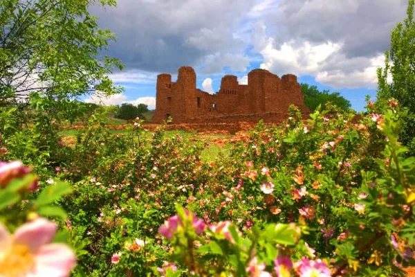
National Monument
Tucked away in the middle of New Mexico you’ll find Salinas Pueblo Missions National Monument. Its three distinct sites offer a glimpse into a unique time in history—a time entrenched with cultural bo...

National Park
Rising from the heart of the Tularosa Basin is one of the world's great natural wonders - the glistening white sands of New Mexico. Great wave-like dunes of gypsum sand have engulfed 275 square miles...
Park data from the National Park Service API. Alerts update every 2 hours.
This drive has a 'turn-heavy local drive' profile, meaning you'll likely encounter more intersections and changes in direction than you would on a straight interstate. With only 22% of the route on highways, most of your time will be spent on local roads. The longest stretch without a turn is 47.3 miles on Main Street, which offers a solid period of consistent travel before you need to navigate again. Be prepared for a varied driving experience as you transition between different road types.
Expect a hands-on drive with frequent turns and local roads rather than long highway stretches. Navigation is very simple - set it and forget it for most of the drive. The trickiest moment comes early in the drive near Center Avenue.
Very easy - short and simple to drive
Balances navigation complexity with total wheel time.
The drive from Moriarty, NM to Alamogordo, NM is easy. At 3h 46m with 22% highway, most drivers will find it relaxed and low-stress.
Where does it get tricky?
The main spots that need attention: near the start (Center Avenue): Navigation decision point; at 0.1 miles (NM 41 / Howard Cavazos Boulevard South): Navigation decision point; at 26.9 miles (US 60): Navigation decision point.
Weekend Trip
Doable as a same-day drive at 3h 46m. Total distance: 168.3 miles.
Family Friendly
Moderate complexity with 1 natural rest stops along the way.
Solo Traveler
3h 46m drive, comfortable solo distance.
First-Time Driver
Mostly highway driving (22%). Straightforward navigation.
Scenic Drive
Mostly surface roads route profile with national parks nearby.
Compiled by the US Trip Planner planning team at COD Solutions Oy from open government datasets — OSRM over OpenStreetMap for geometry, EIA for fuel prices, and NPS for national parks. See our methodology for refresh cadence and limitations.
Was this helpful?
Thanks for your feedback!
Your tip has been submitted. Thanks!
/500
Recent Tips
·
Explore more options from Moriarty, NM or browse trips ending in Alamogordo, NM.
Looking for more statewide routes? Browse NM road trips.