Quartzite River Access
0 mi from route
Compiled and reviewed by the US Trip Planner planning team at COD Solutions Oy · Last reviewed Jul 19, 2026 · Editorial standards
Drive Time
6h 45m
Distance
296.6 mi
477 km
Drive Score
9/10
Great drive
Same Day?
Yes, doable
Fuel Cost
$41
one way
EV Charging
Unknown
Estimated drive times based on typical traffic patterns. Actual times may vary with weather, construction, and real-time conditions.

Alamogordo, NM
Wikimedia Commons

Arroyo Seco, NM
Patagonia Savage
Alamogordo, NM to Arroyo Seco, NM is 296.6 miles and takes about 6h 45m via US 54 and NM 68, with a fuel budget near $45 and enough daylight to finish in a day. This trip stays within the Desert Southwest region, offering a straightforward, highway-focused experience. You'll find it's a manageable drive for a single day, with most of your time spent on main roads. Consider this route if you're looking for an efficient way to travel between these two New Mexico points without excessive detours.
Trip Pace
Same-day drive is realistic
A same-day return is possible, but it will make for a full day on the road.
Break Rhythm
1 planned break
Plan on a short reset every 3 to 4 hours to stay fresh behind the wheel.
Midpoint
148.3 miles from Alamogordo, NM
A natural place for your longest stop of the day , about 3h 19m into the drive .
| Road | Distance | Duration |
|---|---|---|
| US 54 | 110.2 mi | 2h 27m |
| Shenrick Street | 68.6 mi | 1h 21m |
| New Mexico State Highway 68 | 38.6 mi | 53m |
| NM 3 | 14.5 mi | 21m |
| Taos Highway | 12.2 mi | 14m |
| US 54,70 | 9.8 mi | 12m |
| Santa Fe Highway | 8.7 mi | 13m |
| I 25 | 5.9 mi | 5m |
Hour-of-day weekday pattern from 4 FHWA count stations on your route.
Peak
4 PM
~1,079 veh/hr typical · worst 1,327
Quietest
2 AM
~43 veh/hr
Peak-to-quiet ratio
25.1×
busier at peak than in the quiet hours
Averaged across 42 weeks of 2023 FHWA Travel Monitoring Analysis System data. Weekday hours only (Mon–Fri).
Step-by-step road directions between Alamogordo, NM and Arroyo Seco, NM.
Start on North White Sands Boulevard
Continue on US 54; US 70
Turn left onto US 54
Turn left onto NM 3
Turn left onto US 60; US 285
Turn left onto US 285
Merge onto I 25
Take the exit
Keep slight right at fork
Turn straight onto NM 466
Keep slight right at fork onto Old Pecos Trail
Continue on Old Santa Fe Trail
Turn left onto East Alameda Street
Turn right onto North Guadalupe Street
Take the ramp
Merge onto US 84; US 285
Continue on US 84; US 285
Continue on US 84; US 285
Continue on US 84; US 285
Continue on NM 68
Continue on NM 68
Continue on NM 68
Turn left onto NM 240
Continue on NM 240
Continue on NM 240
Continue on NM 240
Turn left onto CR BA007
Keep slight left at fork onto CR BA007
Turn right onto US 64
Turn straight
Turn left onto NM 522
Turn right onto Valencia Road
At end of road, turn left onto NM 230
Turn right onto Hondo Seco Road
Turn left onto Holy Trinity Road
Continue on Holy Trinity Road
Continue on Holy Trinity Road
Turn sharp left
Turn right
Arrive at destination
Aim to start your journey in Alamogordo early to make the most of the 6h 45m driving time, especially since it's a one-day trip. With a single recommended stop, plan your break strategically to cover the longest stretch of 110.2 miles on US 54. Fuel costs are estimated at $45, so ensure your tank is full before departing Alamogordo, as services might be less frequent during that longer segment. The total distance of 296.6 miles is very achievable in a single day, offering flexibility in your timing.
Morning Departure
Start early — leave by 6-7 AM to arrive at a reasonable hour.
Evening Departure
This is a long drive — plan for a morning departure or consider splitting it into two days.
This is a comfortable same-day trip.
Departure
Before you leave
Start with fuel, water, and navigation already sorted so the first hour feels easy.
First stop
Around 65 miles or 1h 27m in
Use this first pause for coffee, a restroom break, and a quick traffic check ahead.
Halfway reset
Around 148.3 miles or 3h 19m in
This is the best place for your longest stop, a real meal, and a full fuel check.
Final approach
Final hour starts around 5h 21m
Traffic, exits, and arrival timing usually matter more near Arroyo Seco, NM than in the middle of the route.
Open the route before leaving Alamogordo, NM so your first major turns are already loaded.
Leave with enough water and a charging cable within reach, not packed away.
Check your fuel range against the first long segment, especially if you are starting outside city service areas.
Day 1
Settle into the route from Alamogordo, NM
This is one driving day of about 296.6 miles and 6h 45m.
Rest stops, refuel points, and overnight suggestions along this route.

Mid-route town
Meal stop
148 mi into the route
Best for: Lunch, fuel, and a longer reset
This sits close to the middle of the route, so it works well for the longest stop of the day.
A short stop after about 65 miles helps settle the day before fatigue starts building.
The midpoint is around 148.3 miles from Alamogordo, NM, which is a good place for a longer meal and fuel stop.
Before the longest stretch
Fuel checkTop up before US 54 if your tank is already low. That segment runs about 110.2 miles.
These stop ideas are pacing suggestions — the exact town or exit can change with traffic, hotel plans, and fuel range.
Picked by where they fit in your drive — first break, midpoint reset, final stretch.
Near the start, right off the route
Alamogordo, New Mexico
Hours: 9 am–5 pm
+15754394290
Visit websiteNear the start, right off the route
Alamogordo, New Mexico
Hours: 10 am–4 pm
+15754344438
Visit websiteNear the start, right off the route
Alamogordo, New Mexico
Hours: 10 am–1 pm
+15753080083
Visit websiteNear the start, right off the route
Alamogordo, New Mexico
Near the start, short detour
Alamogordo, New Mexico
Hours: Open 24 hours
+15754394100
Visit websiteLater in the drive, short detour
Santa Fe, New Mexico
Hours: 10 am–5 pm
+15054761204
Visit websiteLater in the drive, short detour
Santa Fe, New Mexico
Hours: 10 am–5 pm
+15054761269
Visit websiteNear the start, short detour
Alamogordo, New Mexico
Hours: 1–5 pm
+15754155206
Visit websitePlace data sourced from public business listings. Hours and availability may vary.
5 decision points cluster between mile 212.5 and 296.6 — GPS handles the exact turns, but know they're coming. Your lane choice matters more than the turn itself.
Keep slight right at fork
Highway fork - watch signs carefully
Turn right onto North Guadalupe Street
Lane positioning matters here
At end of road, turn left onto NM 230
Navigation decision point
Turn sharp left
Sharp turn - reduce speed on approach
Turn right
Navigation decision point
Regular Gas
$41.17 one way
$82.35 round trip
| Fuel Type | $/gal | One Way | Round Trip |
|---|---|---|---|
| midgrade | $3.95 | $46.07 | $92.13 |
| premium | $4.29 | $50.08 | $100.17 |
| diesel | $4.80 | $56.00 | $112.01 |
No toll roads detected on this route.
Estimated Trip Cost (one way, 1 person)
Fuel
$41
Meals
$25–$50
Total
$66–$91
Rough estimate based on US averages. Hotel $80–$140/night, meals $25–$50/day.
Estimated CO2 emission: 103.8 kg one way. Prices: EIA weekly data, 2026-07-13.
Driving Electric?
About $31 in charging · 1 stop · 66% less CO2
| Vehicle Type | kWh | Stops | DC Fast | Home Charge |
|---|---|---|---|---|
| Average EV | 89 | 1 | $31.14 | $14.24 |
| Efficient EV | 74.2 | 0 | $25.95 | $11.86 |
| EV Truck/SUV | 118.6 | 1 | $41.52 | $18.98 |
Gas CO2
104 kg
EV CO2
35 kg (66% less)
Plan for 1 charging stop. A 30-minute DC fast charge mid-route should be enough to complete the trip comfortably.
DC fast charging avg $0.35/kWh. Home charging avg $0.16/kWh. US grid CO2: 0.39 kg/kWh.
Current conditions at both ends of the drive.
Origin
Late night in Alamogordo on Sunday
Local time
12:45 AM
MDT
Current temp
88°F
Chance Showers And Thunderstorms
Special Weather Statement
Special Weather Statement issued July 17 at 3:53PM MDT by NWS El Paso Tx/Santa Teresa NM
Flash Flood Warning
Flash Flood Warning issued July 17 at 3:50PM MDT until July 17 at 6:00PM MDT by NWS Albuquerque NM
Destination
Late night in Arroyo Seco on Sunday
Local time
12:45 AM
MDT
Current temp
79°F
Showers And Thunderstorms Likely
Special Weather Statement
Special Weather Statement issued July 17 at 3:53PM MDT by NWS El Paso Tx/Santa Teresa NM
Flash Flood Warning
Flash Flood Warning issued July 17 at 3:50PM MDT until July 17 at 6:00PM MDT by NWS Albuquerque NM
92°F
Santa Fe, NM
148 mi in
Seasonal Notes
Summer travel usually means heavier construction, hotter rest stops, and busier weekend traffic around major cities.
Winter travel shortens daylight, so a route that looks manageable on paper can feel much longer after dark.
Holiday weekends tend to make both departure and arrival windows slower than the raw route time suggests.
Time zone
Origin and destination are on the same clock, so arrival timing is easier to judge at a glance.
Temperature spread
A meaningful temperature swing is a good cue to rethink layers, water, and how soon you want to arrive.
Road read
Start early — leave by 6-7 AM to arrive at a reasonable hour.
Weather data from the National Weather Service. Conditions may change; check closer to your travel date.
Worth a detour if your schedule allows.
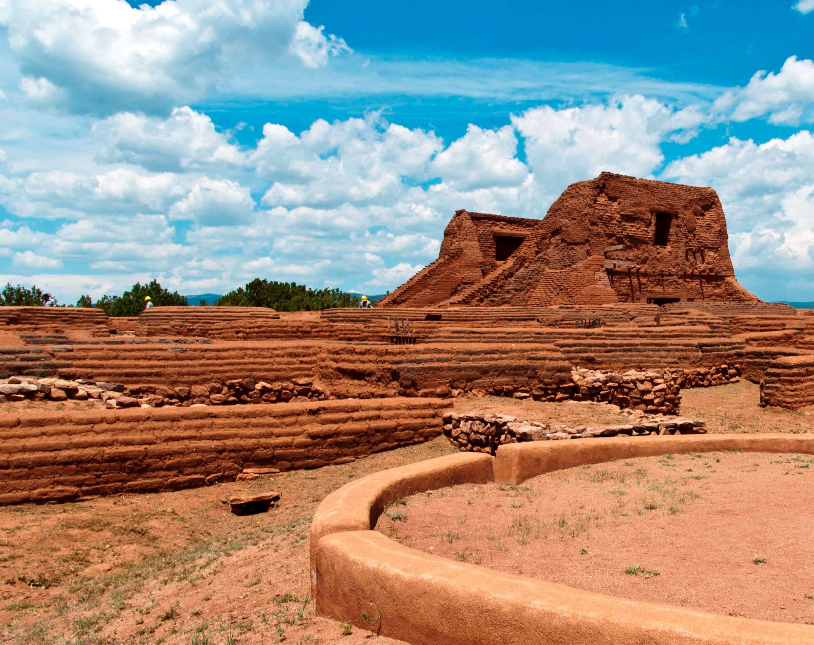
National Historical Park
Pecos is a natural and cultural crossroads through which hunters, gatherers, traders, missionaries, immigrants, soldiers, ranchers, and other travelers passed and lived. Follow in their footsteps and...
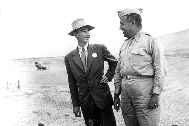
National Historical Park
The Manhattan Project is one of the most transformative events of the 20th century. It ushered in the nuclear age with the development of the world’s first atomic bombs. Most of this development took...
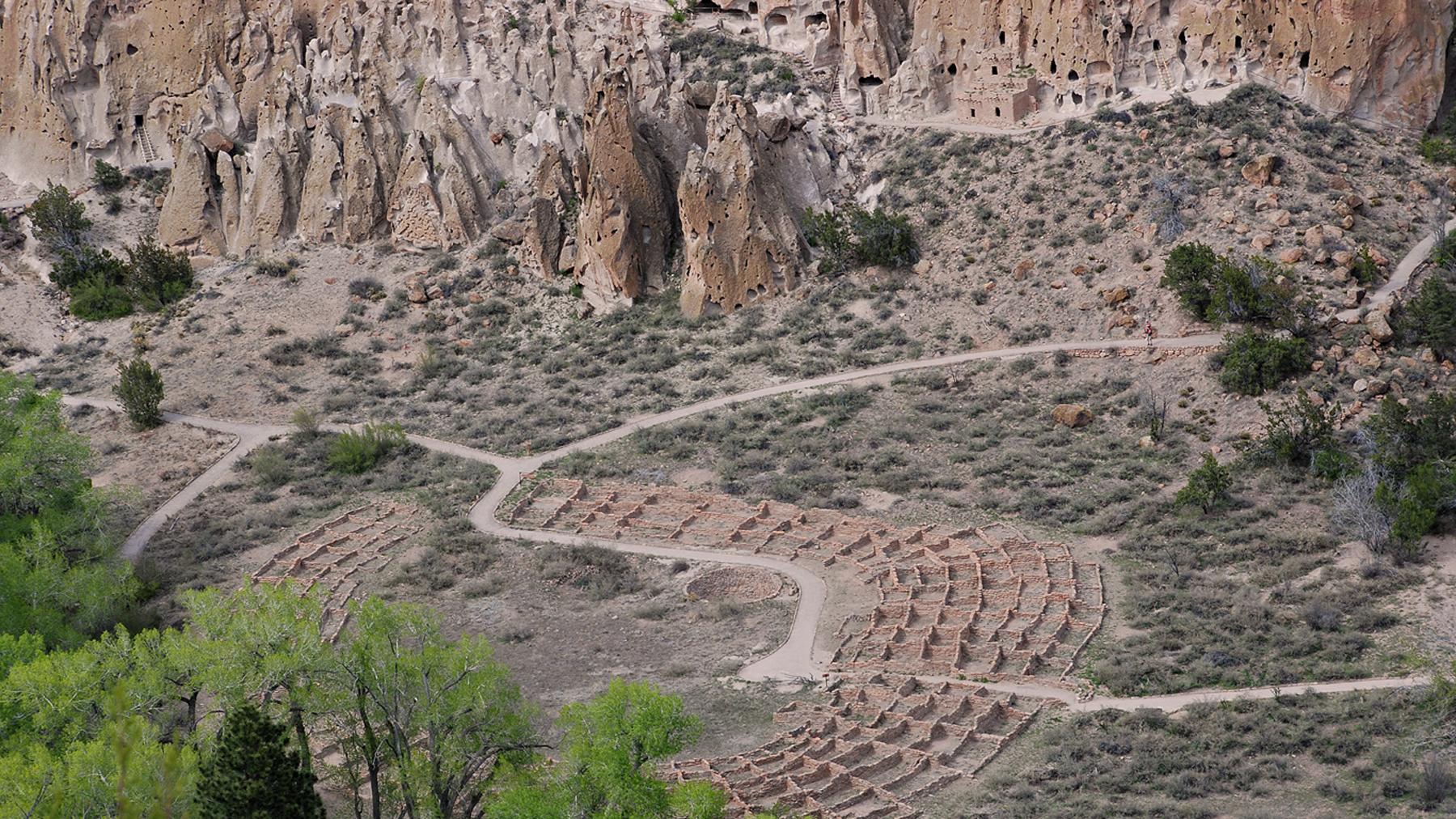
National Monument
Bandelier National Monument protects over 33,000 acres of ruggedly beautiful canyon and mesa country. Petroglyphs, dwellings carved into the soft rock cliffs, and standing masonry walls pay tribute to...
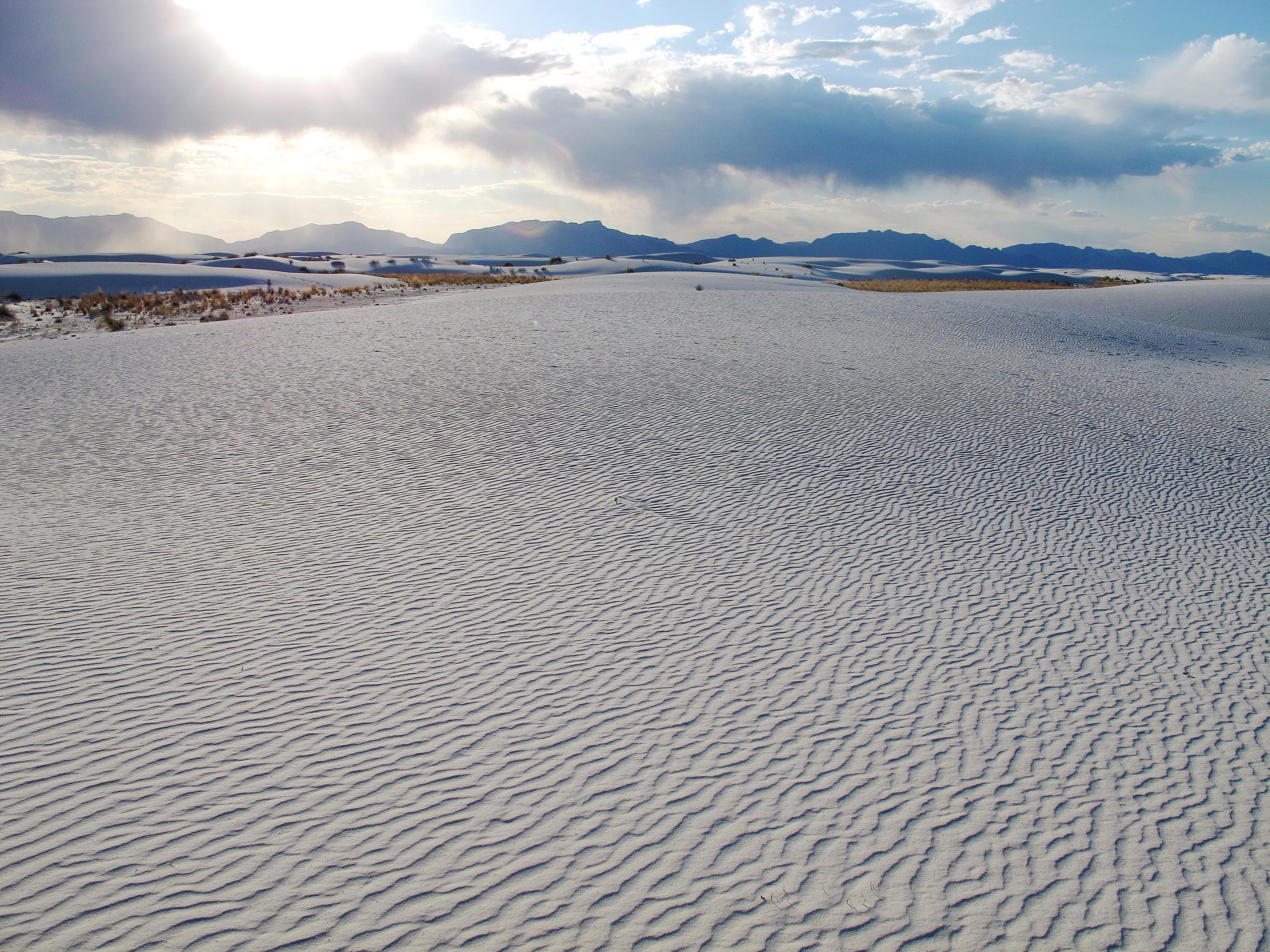
National Park
Rising from the heart of the Tularosa Basin is one of the world's great natural wonders - the glistening white sands of New Mexico. Great wave-like dunes of gypsum sand have engulfed 275 square miles...
Park data from the National Park Service API. Alerts update every 2 hours.
This drive is primarily highway-focused, with 62% of the journey on major roads like US 54 and New Mexico State Highway 68. You'll encounter a substantial uninterrupted stretch of 110.2 miles on US 54, which will likely be your longest continuous driving segment. While the highway component dominates, there are moments where you'll transition to local streets, such as Shenrick Street, as you approach your destination. Expect a generally consistent driving pace with opportunities to cover ground efficiently.
This is a straightforward highway drive that stays mostly on US 54 and Shenrick Street. This route has several spots where lane changes, forks, or exits need your full attention. The trickiest moment comes around 212.5 miles in.
Demanding - plan breaks and stay ahead of the key maneuvers
Balances navigation complexity with total wheel time.
This is a demanding drive. With 23 significant decision points across 296.6 miles, you will need to stay alert - especially through interchange areas and urban stretches. Consider splitting it into segments if you are not comfortable with fast highway navigation.
Where does it get tricky?
The main spots that need attention: at 212.5 miles: Highway fork - watch signs carefully; at 216.5 miles (North Guadalupe Street): Lane positioning matters here; at 293.2 miles (NM 230): Navigation decision point.
High-altitude sections with notable climbs
Total Climb
5,589 ft
Total Descent
2,286 ft
Highest Point
7,638 ft
~296.6 mi in
Elevation Range
3,302 ft
Notable High Points
Founded 1898
Alamogordo is a small city in southeastern New Mexico. The town is the county seat for Otero County and supports two major nearby military installations, Holloman Air Force Base and the White Sands Missile Range.
Top landmarks
City content from Wikivoyage (CC BY-SA 4.0) and Wikidata (CC0).
Weekend Trip
Doable as a same-day drive at 6h 45m. Total distance: 296.6 miles.
Family Friendly
Moderate complexity with 1 natural rest stops along the way.
Solo Traveler
6h 45m drive, plan rest stops for pacing.
Compiled by the US Trip Planner planning team at COD Solutions Oy from open government datasets — OSRM over OpenStreetMap for geometry, EIA for fuel prices, USGS 3DEP for elevation, NPS for national parks, and FHWA TMAS for hourly traffic volumes. See our methodology for refresh cadence and limitations.
Was this helpful?
Thanks for your feedback!
Your tip has been submitted. Thanks!
/500
Recent Tips
·
Explore more options from Alamogordo, NM or browse trips ending in Arroyo Seco, NM.
Looking for more statewide routes? Browse NM road trips.