This 131.3-mile drive from Las Vegas, New Mexico, to South Valley, New Mexico, is easily manageable as a single-day trip, taking approximately 2 hours and 25 minutes. The route is primarily highway-focused, with 95% of the journey utilizing major roads like I-25 and local arteries such as Rio Bravo Boulevard Southeast and Isleta Boulevard Southwest. Given its relatively short length and the estimated $20 fuel cost, it’s a straightforward option for a quick transition between two points within the Desert Southwest region. No overnight stops are necessary, making it perfect for a day trip.
Trip Pace
Same-day drive is realistic
A same-day return is realistic if you keep stops short.
Midpoint
65.6 miles from Las Vegas, NM
A natural place for your longest stop of the day
, about 1h 8m into the drive
.
Main Roads
Road
Distance
Duration
I 25
124.7 mi
2h 7m
Rio Bravo Boulevard Southeast
2.3 mi
3m
Isleta Boulevard Southwest
1.7 mi
3m
National Avenue
0.6 mi
1m
East University
0.2 mi
<1m
4th Street
<0.1 mi
<1m
Grand Avenue
<0.1 mi
<1m
Bridge Street
<0.1 mi
<1m
Longest stretch:
I 25
— 124.7 mi, about 2h 7m
Turn-by-Turn Driving Directions
Step-by-step road directions between Las Vegas, NM and South Valley, NM.
1
Start on Bridge Street
91 ft·1 sec·Bridge Street
2
Continue on National Avenue
0.6 mi·1 min·National Avenue
3
Turn right onto 4th Street
284 ft·12 sec·4th Street
4
Turn right onto I 25 Bus
218 ft·11 sec·Grand Avenue
5
Turn left onto NM 104
0.2 mi·20 sec·East University
6
Take the ramp
0.3 mi·40 sec
7
Merge onto I 25
125 mi·2 hr 7 min·I 25
Use the straight / slight right lanes.
8
Take the exit
0.4 mi·48 sec
Exit 220Toward NM 500: Rio Bravo BoulevardUse the slight right lane.
9
Keep slight right at fork
0.1 mi·16 sec
Toward Rail Runner StationUse the slight right lane.
10
Turn straight onto NM 500
2.3 mi·3 min·Rio Bravo Boulevard Southeast
11
Turn left onto Isleta Boulevard Southwest
1.7 mi·3 min·Isleta Boulevard Southwest
12
Turn left
0.1 mi·50 sec
13
Turn left
0.7 mi·7 min
14
Arrive at destination
Trip Plan
With a total duration of just 2 hours and 25 minutes, this route offers plenty of flexibility for departure times. You can leave Las Vegas, NM, in the morning and arrive in South Valley, NM, with ample daylight remaining. Consider departing mid-morning to avoid early rush hour traffic, though the drive is unlikely to be heavily congested. The longest stretch without a major change in road type is over 124 miles on I-25, so plan your fuel and rest stops accordingly before embarking on that segment. Keep an eye on your fuel gauge, as the estimated $20 cost suggests it's a cost-effective trip where you won't need frequent fill-ups.
Morning Departure
Leave by 9 AM and you'll arrive before lunch.
Evening Departure
Even a 4 PM departure gets you there before dark in summer.
You can normally do this drive in one day.
You may only need one short stretch break if traffic stays light.
The halfway point lands around 65.6 miles from Las Vegas, NM, or about 1h 8m into the drive.
The longest continuous stretch on this route runs about 124.7 miles.
This is a comfortable same-day trip.
Departure
Before you leave
Start with fuel, water, and navigation already sorted so the first hour feels easy.
First stop
Around 29 miles or 30m in
Use this first pause for coffee, a restroom break, and a quick traffic check ahead.
Halfway reset
Around 65.6 miles or 1h 8m in
This is the best place for your longest stop, a real meal, and a full fuel check.
Final approach
Final hour starts around 1h 51m
Traffic, exits, and arrival timing usually matter more near South Valley, NM than in the middle of the route.
Before You Leave
+
Open the route before leaving Las Vegas, NM so your first major turns are already loaded.
+
Leave with enough water and a charging cable within reach, not packed away.
+
Check your fuel range against the first long segment, especially if you are starting outside city service areas.
Day 1
Settle into the route from Las Vegas, NM
This is one driving day of about 131.3 miles and 2h 25m.
Your first comfortable stop window is around 29 miles from Las Vegas, NM.
This route can stay practical as a one-day drive if traffic stays reasonable.
The longest stretch is on I 25 for about 124.7 miles.
Where to Stop
Rest stops, refuel points, and overnight suggestions along this route.
Place data sourced from public business listings. Hours and availability may vary.
Heads-up: tricky spots
5 of 8
5 decision points cluster between mile 0.6 and 126.3 — GPS handles the exact turns, but know they're coming. Your lane choice matters more than the turn itself.
4
0.6 mi into trip|~1m in|4th Street
Turn right onto 4th Street
Navigation decision point
5
0.7 mi into trip|~1m in|NM 104 / East University
Turn left onto NM 104 / East University
Navigation decision point
5
1.3 mi into trip|~2m in|I 25
Merge onto I 25
Merge point - match speed before joining. Lane positioning matters here
Use the straight / slight right lanes.
7
126 mi into trip|~2h 9m in
Take the exit toward NM 500: Rio Bravo Boulevard
Exit ramp - move to the correct lane early. Lane positioning matters here
Use the slight right lane.
Exit 220
Toward NM 500: Rio Bravo Boulevard
7
126.3 mi into trip|~2h 10m in
Keep slight right at fork toward Rail Runner Station
Highway fork - watch signs carefully. Lane positioning matters here
Use the slight right lane.
Toward Rail Runner Station
Fuel & Cost
Regular Gas
$19.83 one way
$39.66 round trip
$3.84/gal25.4 MPG avg46 kg CO2
Fuel Type
$/gal
One Way
Round Trip
midgrade
$4.21
$21.77
$43.54
premium
$4.56
$23.57
$47.13
diesel
$5.61
$28.99
$57.98
No toll roads detected on this route.
Estimated Trip Cost (one way, 1 person)
Fuel
$20
Meals
$25–$50
Total
$45–$70
Rough estimate based on US averages. Hotel $80–$140/night, meals $25–$50/day.
Estimated CO2 emission: 45.9 kg one way.
Prices: EIA weekly data, 2026-04-13.
Driving Electric?
About $14 in charging
· 0 stops
· 67% less CO2
Vehicle Type
kWh
Stops
DC Fast
Home Charge
Average EV
39.4
0
$13.79
$6.30
Efficient EV
32.8
0
$11.49
$5.25
EV Truck/SUV
52.5
0
$18.38
$8.40
Gas CO2
46 kg
EV CO2
15 kg (67% less)
This trip is well within single-charge range for most EVs. No charging stops needed if you start fully charged.
DC fast charging avg $0.35/kWh. Home charging avg $0.16/kWh. US grid CO2: 0.39 kg/kWh.
Travel Intel
Current conditions at both ends of the drive.
Forecast as of Apr 15, 2026
Origin
Las Vegas, NM
Morning
in Las Vegas on Sunday
Local time
6:05 AM
MDT
Current temp
73°F
Unavailable
Live forecast
Destination
South Valley, NM
Morning
in South Valley on Sunday
Local time
6:05 AM
MDT
Current temp
82°F
Unavailable
Live forecast
72°F
Santa Fe, NM
66 mi in
Seasonal Notes
Summer travel usually means heavier construction, hotter rest stops, and busier weekend traffic around major cities.
Winter travel shortens daylight, so a route that looks manageable on paper can feel much longer after dark.
Holiday weekends tend to make both departure and arrival windows slower than the raw route time suggests.
Time zone
Same local time
Origin and destination are on the same clock, so arrival timing is easier to judge at a glance.
Temperature spread
9 degrees warmer at arrival
A meaningful temperature swing is a good cue to rethink layers, water, and how soon you want to arrive.
Road read
2h 25m on the road
Use the two city cards together: check the sky where you start, then compare it with the local time and temperature at arrival.
Weather data from the National Weather Service. Conditions may change; check closer to your travel date.
National Parks Near This Route
Worth a detour if your schedule allows.
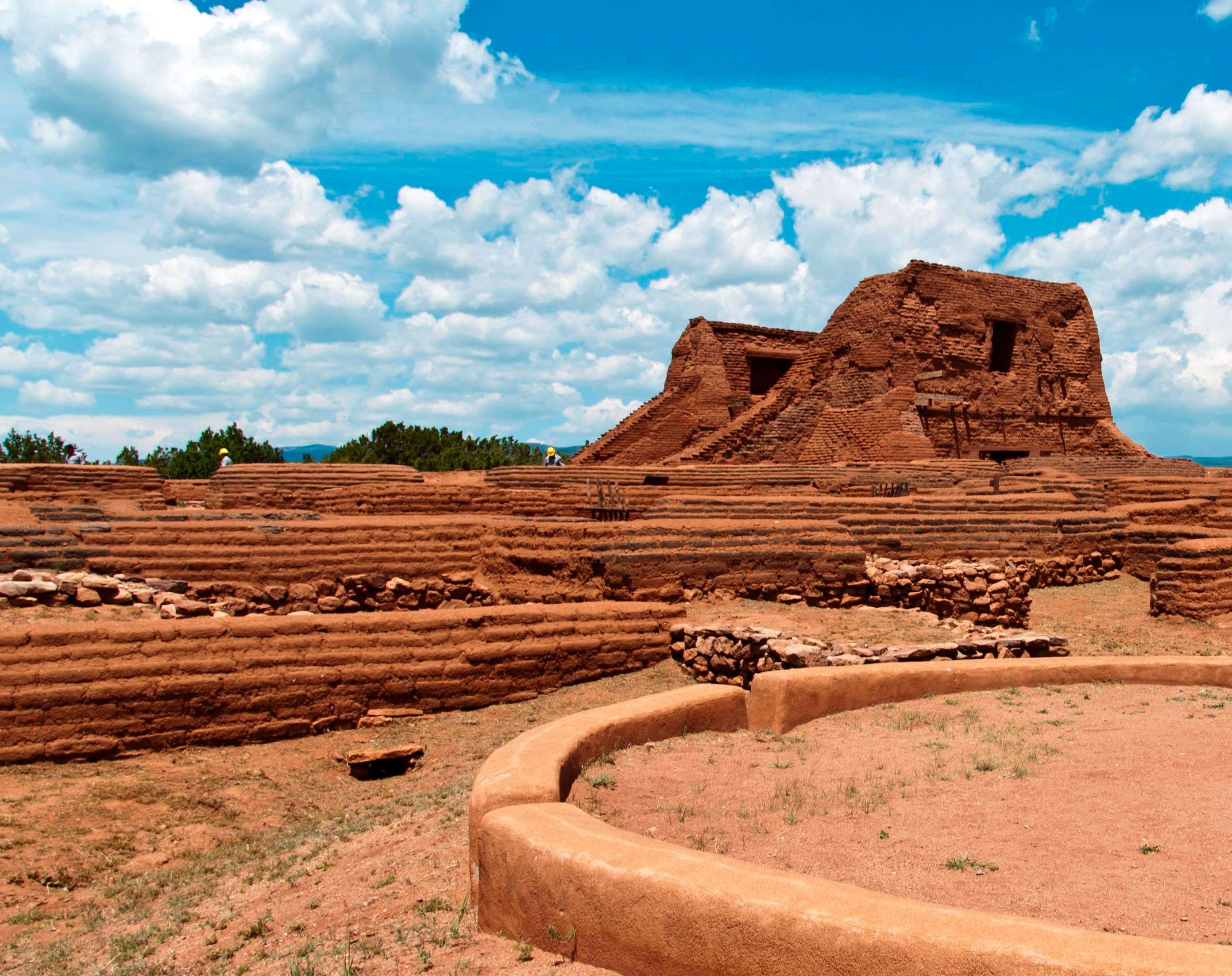
Pecos National Historical Park
National Historical Park
Pecos is a natural and cultural crossroads through which hunters, gatherers, traders, missionaries, immigrants, soldiers, ranchers, and other travelers passed and lived. Follow in their footsteps and...
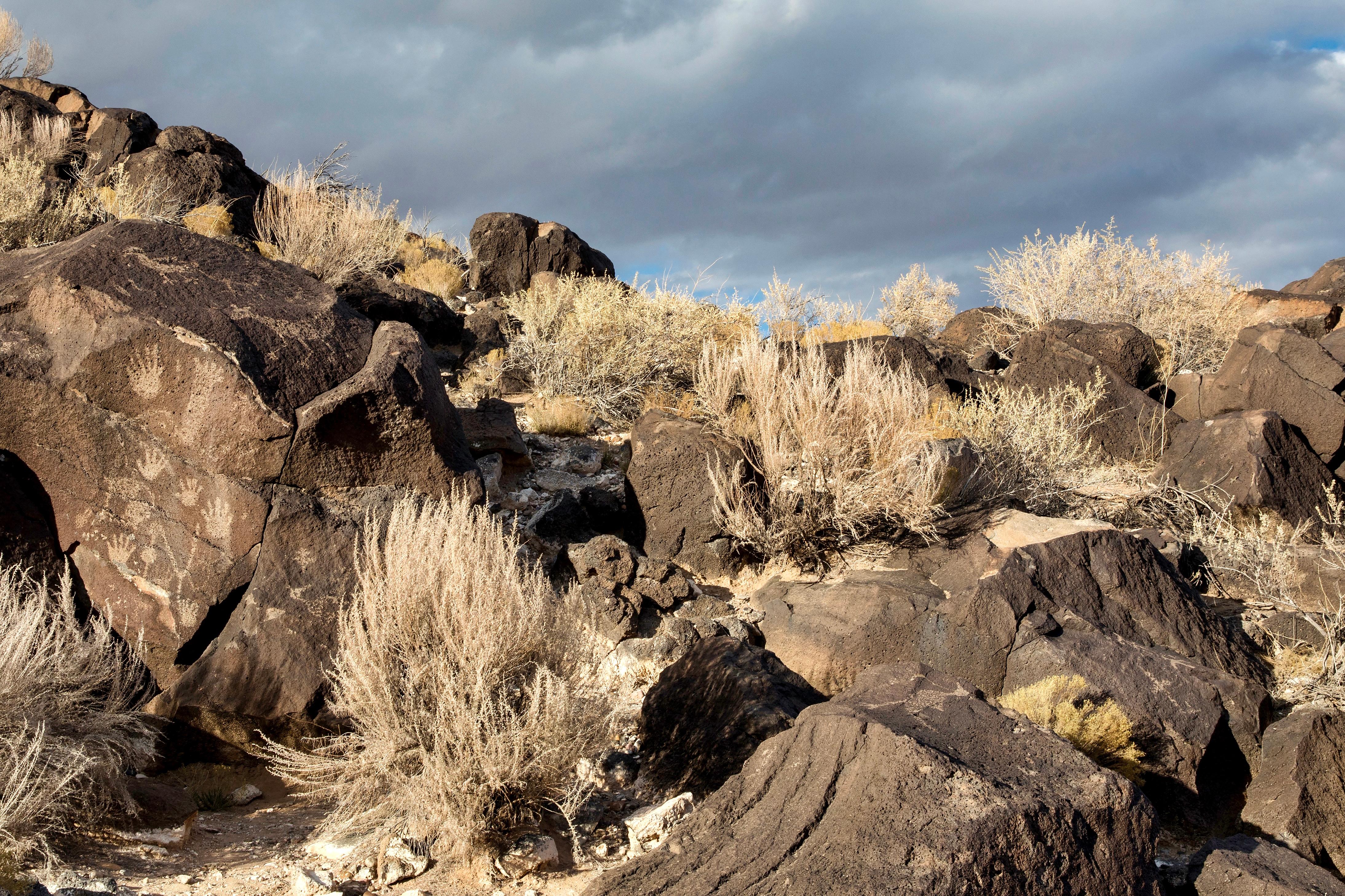
Petroglyph National Monument protects one of the largest petroglyph sites in North America, featuring designs and symbols carved onto volcanic rocks by Native Americans and Spanish settlers 400 to 700...
7 mi from route
~19 min detour
Free
near mile 122.2
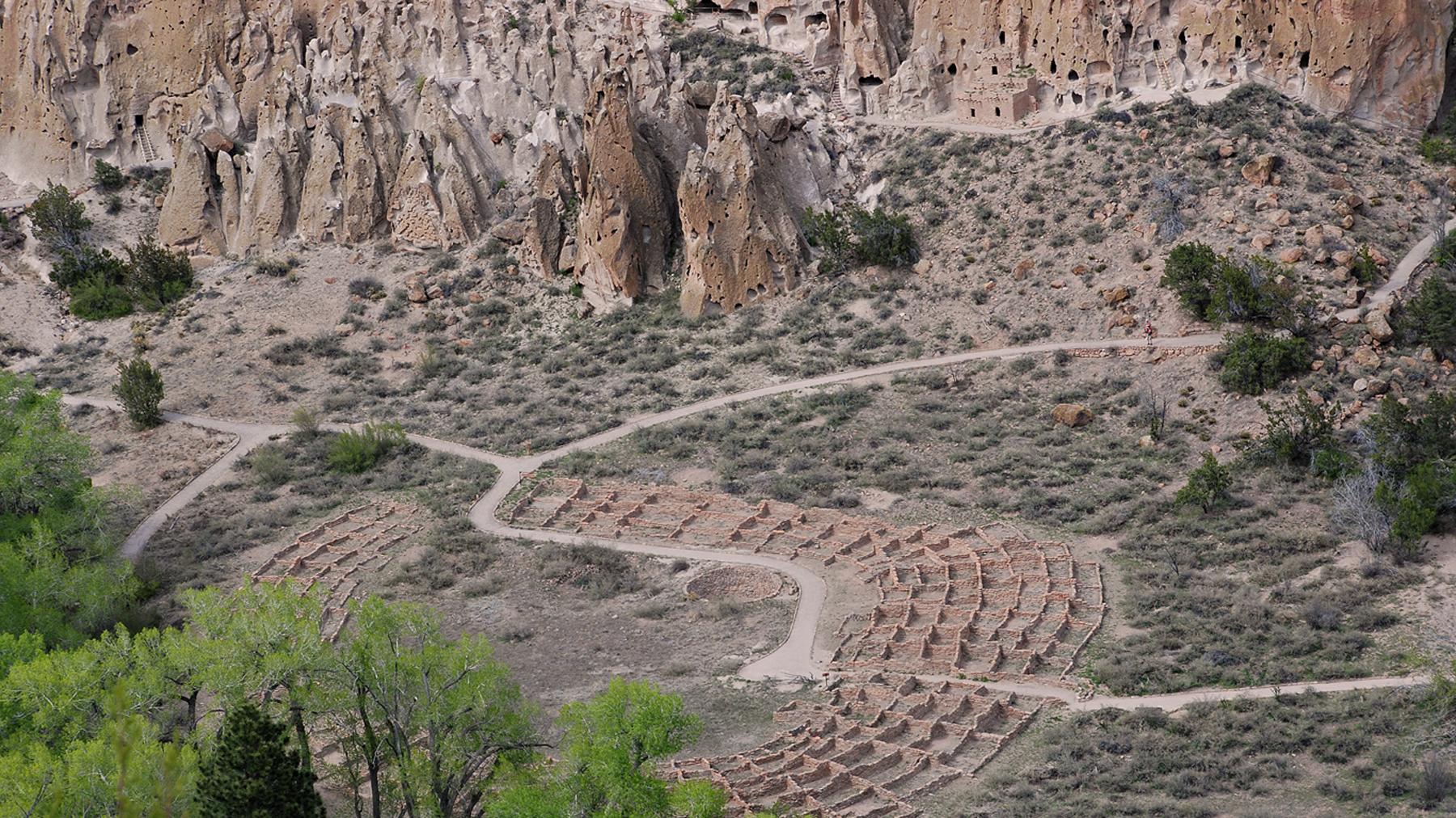
Bandelier National Monument protects over 33,000 acres of ruggedly beautiful canyon and mesa country. Petroglyphs, dwellings carved into the soft rock cliffs, and standing masonry walls pay tribute to...
19 mi from route
~48 min detour
$25
near mile 81.5
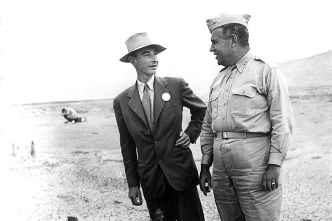
The Manhattan Project is one of the most transformative events of the 20th century. It ushered in the nuclear age with the development of the world’s first atomic bombs. Most of this development took...
24 mi from route
~61 min detour
Free
near mile 72.4
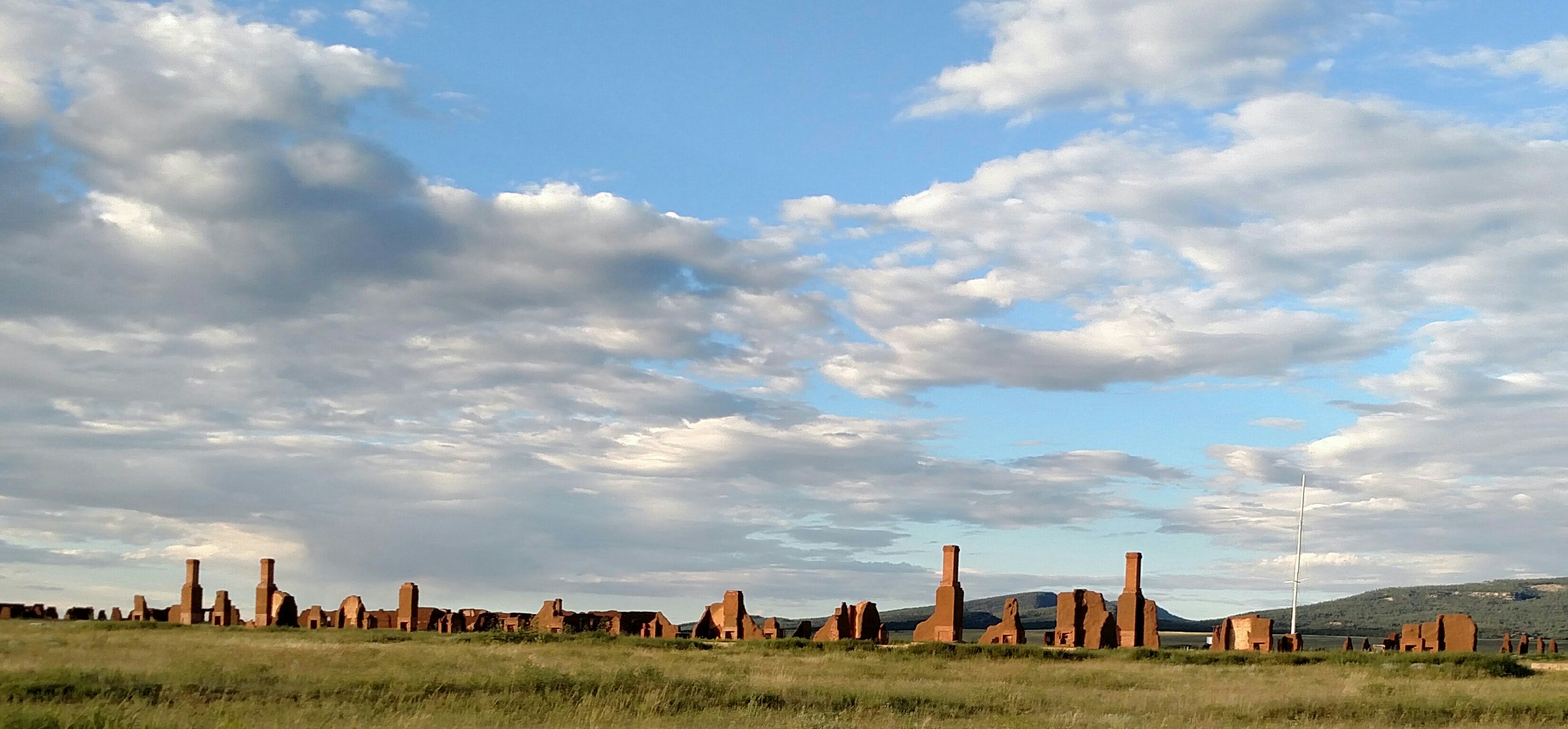
Exposed to the wind, within a sweeping valley of short grass prairie, and along the eroded Santa Fe Trail, lie the adobe walled ruins of the largest 19th century military fort in the region. From 1851...
Park data from the National Park Service API. Alerts update every 2 hours.
More Details
What kind of drive is this?
Expect a predominantly highway-focused experience on this route, with a substantial 95% of the drive on major roads. The longest uninterrupted stretch is an impressive 124.7 miles along I-25, offering a consistent pace for a significant portion of your journey. While the majority is interstate, you’ll transition onto Rio Bravo Boulevard Southeast and Isleta Boulevard Southwest towards the end, introducing local road elements as you approach your destination. This blend means you’ll experience both open highway cruising and more urban driving as the trip progresses.
95% highway — fuel and pacing are the main things to plan.
14 navigation steps total — most of the decisions cluster near the start and finish.
Longest single stretch: 124.7 mi on I 25.
How Hard Is This Drive?
4/10
This is a straightforward highway drive that stays mostly on I 25 and Rio Bravo Boulevard Southeast. There are only a few real navigation decisions along the way. The trickiest moment comes around 0.6 miles in near 4th Street.
Driving Effort4/10
Easy - simple navigation with a manageable amount of wheel time
Balances navigation complexity with total wheel time.
This is a straightforward 2h 25m drive. You will face about 8 decision points, but nothing that requires special attention if you follow navigation.
Where does it get tricky?
The main spots that need attention: at 0.6 miles (4th Street): Navigation decision point; at 0.7 miles (NM 104 / East University): Navigation decision point; at 1.3 miles (I 25): Merge point - match speed before joining. Lane positioning matters here.
Las Vegas is a lovely town in New Mexico in the United States of America. It is an under appreciated gem and a far cry from the Southwestern chic of nearby Santa Fe, with a large collection of historic Victorian homes and other remnants from when Las Vegas was a roaring railroad town. Other attractions include the Montezuma Castle, Storrie Lake, and the New Mexico Highlands University.
The longest stretch is about 124.7 miles on I 25. The full list of main roads is in the Roads section above.
Yes, with realistic expectations. Build in a stop roughly every 2 hours, have snacks and activities ready, and check the Nearby Places tabs for kid-friendly stops along the way.
Mostly yes along the main roads, but rural stretches through NM can have sparse or no coverage. Before you leave, download offline Google Maps or Apple Maps for the route, and consider downloading music or podcasts instead of streaming. If you depend on data for navigation, keep a paper backup of the turn-by-turn directions.
The main spots that need attention: at 0.6 miles (4th Street): Navigation decision point; at 0.7 miles (NM 104 / East University): Navigation decision point; at 1.3 miles (I 25): Merge point - match speed before joining. Lane positioning matters here.
Yes — Pecos National Historical Park, Petroglyph National Monument and Bandelier National Monument (5 total within detour distance). See the National Parks section for detour distances and tips on detours.
Yes. A round trip is manageable in a single day if you plan a break at South Valley, NM before heading back.