Spanning 268.6 miles across the Desert Southwest, this journey from Las Vegas to Farmington typically takes about 4 hours and 7 minutes behind the wheel. Because this route is a turn-heavy local drive rather than a straight interstate shot, it is best approached as a single-day commitment. You should budget approximately $40 for fuel to complete the trip comfortably. While it is certainly feasible to finish in one day, the winding nature of the roads means you will spend more time actively navigating than you would on a highway. It is a straightforward trip between two distinct New Mexico hubs, perfect for travelers who prefer local roads over the monotony of major freeways.
Trip Pace
Same-day drive is realistic
A same-day return is possible, but it will make for a full day on the road.
Break Rhythm
1 planned break
Plan on a short reset every 3 to 4 hours to stay fresh behind the wheel.
Midpoint
134.9 miles from Las Vegas, NM
A natural place for your longest stop of the day
, about 2h 21m into the drive
.
Main Roads
Road
Distance
Duration
US 550
151.5 mi
2h 50m
I 25
103.1 mi
1h 43m
West Broadway Boulevard
11.3 mi
15m
East Broadway Avenue
1.7 mi
2m
West Broadway Street
0.7 mi
1m
National Avenue
0.6 mi
1m
East University
0.2 mi
<1m
4th Street
<0.1 mi
<1m
Longest stretch:
US 550
— 151.5 mi, about 2h 50m
Traffic on I-25
Hour-of-day weekday pattern from 12 FHWA count stations on your route.
Peak
4 PM
~1,079 veh/hr typical
· worst 1,327
Quietest
2 AM
~43 veh/hr
Peak-to-quiet ratio
25.1×
busier at peak than in the quiet hours
12a6anoon6p11p
Averaged across 42 weeks of 2023 FHWA Travel Monitoring Analysis System data. Weekday hours only (Mon–Fri).
Turn-by-Turn Driving Directions
Step-by-step road directions between Las Vegas, NM and Farmington, NM.
1
Start on Bridge Street
91 ft·1 sec·Bridge Street
2
Continue on National Avenue
0.6 mi·1 min·National Avenue
3
Turn right onto 4th Street
284 ft·12 sec·4th Street
4
Turn right onto I 25 Bus
218 ft·11 sec·Grand Avenue
5
Turn left onto NM 104
0.2 mi·20 sec·East University
6
Take the ramp
0.3 mi·40 sec
7
Merge onto I 25
103 mi·1 hr 43 min·I 25
8
Take the exit
0.3 mi·33 sec
Toward NM 165 East, US 550 North: Placitas, Bernalillo
9
Keep slight right at fork
240 ft·5 sec
10
Merge onto US 550
1.7 mi·3 min·US 550
Use the right lane.
11
Continue on US 550
150 mi·2 hr 47 min·US 550
12
Turn left onto US 64
11 mi·15 min·West Broadway Boulevard
13
Turn slight right onto US 64 Business
1.7 mi·2 min·East Broadway Avenue
14
Continue on US 64 Business
0.7 mi·1 min·West Broadway Street
15
Arrive at destination
US 64 Business
Trip Plan
Given the turn-heavy nature of this 4-hour and 7-minute trip, try to depart early in the morning to avoid fatigue while navigating local roads. You should plan for at least one dedicated stop to stretch your legs and refuel, keeping that $40 fuel estimate in mind as you manage your vehicle's efficiency. Because you are avoiding major highways, remain mindful of changing speed limits as you move between different local thoroughfares. Since this is a localized route, the primary advantage is your flexibility; if you feel tired, you can easily adjust your pace without the pressure of merging into fast-moving highway traffic. Keep a close eye on your GPS, as the lack of long, straight stretches makes navigation through town centers a critical part of your journey.
Morning Departure
An early start around 7-8 AM gets you there with plenty of daylight left.
Evening Departure
A late afternoon start means arriving after dark. Morning is better.
You can normally do this drive in one day.
Plan roughly 1 meaningful break for fuel, food, and rest.
The halfway point lands around 134.9 miles from Las Vegas, NM, or about 2h 21m into the drive.
The longest continuous stretch on this route runs about 151.5 miles.
This is a comfortable same-day trip.
Departure
Before you leave
Start with fuel, water, and navigation already sorted so the first hour feels easy.
First stop
Around 59 miles or 1h in
Use this first pause for coffee, a restroom break, and a quick traffic check ahead.
Halfway reset
Around 134.9 miles or 2h 21m in
This is the best place for your longest stop, a real meal, and a full fuel check.
Final approach
Final hour starts around 3h 58m
Traffic, exits, and arrival timing usually matter more near Farmington, NM than in the middle of the route.
Before You Leave
+
Open the route before leaving Las Vegas, NM so your first major turns are already loaded.
+
Leave with enough water and a charging cable within reach, not packed away.
+
Check your fuel range against the first long segment, especially if you are starting outside city service areas.
Day 1
Settle into the route from Las Vegas, NM
This is one driving day of about 269.8 miles and 4h 56m.
Your first comfortable stop window is around 59 miles from Las Vegas, NM.
This route can stay practical as a one-day drive if traffic stays reasonable.
Plan about 1 real break rather than only quick fuel stops.
The longest stretch is on US 550 for about 151.5 miles.
Where to Stop
Rest stops, refuel points, and overnight suggestions along this route.
Place data sourced from public business listings. Hours and availability may vary.
Heads-up: tricky spots
5 of 7
5 decision points cluster between mile 0.6 and 104.7 — GPS handles the exact turns, but know they're coming. Your lane choice matters more than the turn itself.
4
0.6 mi into trip|~1m in|4th Street
Turn right onto 4th Street
Navigation decision point
5
0.7 mi into trip|~1m in|NM 104 / East University
Turn left onto NM 104 / East University
Navigation decision point
5
104.4 mi into trip|~1h 45m in
Take the exit toward NM 165 East, US 550 North: Placitas, Bernalillo
Exit ramp - move to the correct lane early. Multiple destination signs - pick the right one
Toward NM 165 East, US 550 North: Placitas, Ber...
5
104.6 mi into trip|~1h 46m in
Keep slight right at fork
Highway fork - watch signs carefully
5
104.7 mi into trip|~1h 46m in|US 550
Merge onto US 550
Merge point - match speed before joining. Lane positioning matters here
Use the right lane.
Fuel & Cost
Regular Gas
$37.45 one way
$74.91 round trip
$3.53/gal25.4 MPG avg94 kg CO2
Fuel Type
$/gal
One Way
Round Trip
midgrade
$3.95
$41.90
$83.81
premium
$4.29
$45.56
$91.12
diesel
$4.80
$50.94
$101.89
No toll roads detected on this route.
Estimated Trip Cost (one way, 1 person)
Fuel
$37
Meals
$25–$50
Total
$62–$87
Rough estimate based on US averages. Hotel $80–$140/night, meals $25–$50/day.
Estimated CO2 emission: 94.4 kg one way.
Prices: EIA weekly data, 2026-07-13.
Driving Electric?
About $28 in charging
· 0 stops
· 66% less CO2
Vehicle Type
kWh
Stops
DC Fast
Home Charge
Average EV
80.9
0
$28.33
$12.95
Efficient EV
67.5
0
$23.61
$10.79
EV Truck/SUV
107.9
1
$37.77
$17.27
Gas CO2
94 kg
EV CO2
32 kg (66% less)
Plan for 0 charging stops, roughly every 270 miles. Allow 25-40 minutes per stop at a DC fast charger.
DC fast charging avg $0.35/kWh. Home charging avg $0.16/kWh. US grid CO2: 0.39 kg/kWh.
Travel Intel
Current conditions at both ends of the drive.
Forecast as of Jul 18, 2026
Origin
Las Vegas, NM
Late night
in Las Vegas on Sunday
Local time
12:25 AM
MDT
Current temp
53°F
Partly Cloudy
SW 5 mph9% chanceLive forecast
Flood Watch
Flood Watch issued July 17 at 8:50PM MDT until July 18 at 6:00PM MDT by NWS Albuquerque NM
Destination
Farmington, NM
Late night
in Farmington on Sunday
Local time
12:25 AM
MDT
Current temp
63°F
Chance Showers And Thunderstorms then Mostly Cloudy
E 5 mph31% chanceLive forecast
Flood Watch
Flood Watch issued July 17 at 8:50PM MDT until July 18 at 6:00PM MDT by NWS Albuquerque NM
Seasonal Notes
Summer travel usually means heavier construction, hotter rest stops, and busier weekend traffic around major cities.
Winter travel shortens daylight, so a route that looks manageable on paper can feel much longer after dark.
Holiday weekends tend to make both departure and arrival windows slower than the raw route time suggests.
Time zone
Same local time
Origin and destination are on the same clock, so arrival timing is easier to judge at a glance.
Temperature spread
10 degrees warmer at arrival
A meaningful temperature swing is a good cue to rethink layers, water, and how soon you want to arrive.
Road read
4h 56m on the road
An early start around 7-8 AM gets you there with plenty of daylight left.
Weather data from the National Weather Service. Conditions may change; check closer to your travel date.
National Parks Near This Route
Worth a detour if your schedule allows.
Pecos National Historical Park
National Historical Park
Pecos is a natural and cultural crossroads through which hunters, gatherers, traders, missionaries, immigrants, soldiers, ranchers, and other travelers passed and lived. Follow in their footsteps and...
5 mi from route
~11 min detour
Free
near mile 46.5
Aztec Ruins has some of the best-preserved Chacoan structures of its kind. Learn more about the ancestral Pueblo people in the park's museum and explore the Aztec West great house to see exceptionally...
10 mi from route
~25 min detour
Free
near mile 260.5
Petroglyph National Monument protects one of the largest petroglyph sites in North America, featuring designs and symbols carved onto volcanic rocks by Native Americans and Spanish settlers 400 to 700...
17 mi from route
~43 min detour
Free
near mile 111.7
Bandelier National Monument protects over 33,000 acres of ruggedly beautiful canyon and mesa country. Petroglyphs, dwellings carved into the soft rock cliffs, and standing masonry walls pay tribute to...
20 mi from route
~49 min detour
$25
near mile 74.4
Explore the monumental structures and breathtaking landscape at Chaco, a thriving regional center for the ancestral Pueblo people from 850 to 1250 CE (Common Era), through hiking & biking trails, rang...
21 mi from route
~53 min detour
$25
near mile 223.3
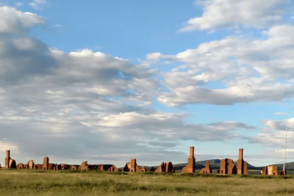
Exposed to the wind, within a sweeping valley of short grass prairie, and along the eroded Santa Fe Trail, lie the adobe walled ruins of the largest 19th century military fort in the region. From 1851...
Park data from the National Park Service API. Alerts update every 2 hours.
More Details
What kind of drive is this?
Expect a technical driving experience as you navigate through local streets like National Avenue, 4th Street, and Grand Avenue. Unlike standard cross-state transit, this route features a 0% highway share, meaning you will be managing turns and shifts in pace throughout the entire 268.6-mile trek. There are no long, uninterrupted stretches here; in fact, the longest stretch on National Avenue is 0 miles, keeping you constantly engaged with your surroundings. You will feel the true character of the New Mexico landscape as you transition away from high-speed transit toward a more hands-on, local driving profile.
94% highway — fuel and pacing are the main things to plan.
15 navigation steps total — most of the decisions cluster near the start and finish.
Longest single stretch: 151.5 mi on US 550.
How Hard Is This Drive?
3/10
This is a straightforward highway drive that stays mostly on US 550 and I 25. There are only a few real navigation decisions along the way. The trickiest moment comes around 0.6 miles in near 4th Street.
Driving Effort3/10
Easy - simple navigation with a manageable amount of wheel time
Balances navigation complexity with total wheel time.
This is a straightforward 4h 56m drive. You will face about 7 decision points, but nothing that requires special attention if you follow navigation.
Where does it get tricky?
The main spots that need attention: at 0.6 miles (4th Street): Navigation decision point; at 0.7 miles (NM 104 / East University): Navigation decision point; at 104.4 miles: Exit ramp - move to the correct lane early. Multiple destination signs - pick the right one.
Elevation Profile
High-altitude sections with notable climbs
7,210 ft5,205 ft
Total Climb
2,928 ft
Total Descent
4,056 ft
Highest Point
7,210 ft
~57.8 mi in
Elevation Range
2,005 ft
Notable High Points
7,210 ft at ~57.8 miles+407 ft prominence
7,155 ft at ~173.5 miles+385 ft prominence
6,964 ft at ~212 miles+163 ft prominence
Towns Mentioned on Route Signs
Based on OSRM destination-sign hints, not a full list of every settlement the road passes.
On the drive from Las Vegas, NM to Farmington, NM, road signs begin pointing toward Bernalillo along the way.
Las Vegas is a lovely town in New Mexico in the United States of America. It is an under appreciated gem and a far cry from the Southwestern chic of nearby Santa Fe, with a large collection of historic Victorian homes and other remnants from when Las Vegas was a roaring railroad town. Other attractions include the Montezuma Castle, Storrie Lake, and the New Mexico Highlands University.
Top landmarks
•Plaza Hotel (New Mexico) — Historic hotel in Las Vegas, New Mexico
•Castañeda Hotel — hotel in Las Vegas, New Mexico, USA
•Las Vegas Plaza — plaza and historic district in Las Vegas, New Mexico
Farmington is a town in the northwest region of the state of New Mexico. It is notable as a gateway to Navajo Nation and the Four Corners area, and as a center for folk art, particularly Navajo weavings. Attractions associated with the nearby towns of Aztec, Bloomfield, Kirtland and Shiprock, about the nearest things that highly rural northwestern New Mexico has to "suburbs," are also covered in this article.
Top landmarks
•Farmington Historic Downtown Commercial District — historic district in Farmington, New Mexico, United States
The longest stretch is about 151.5 miles on US 550. The full list of main roads is in the Roads section above.
We did not find dedicated rest areas on this route. For a drive this long, plan bathroom and stretch breaks around gas stations, fast-food stops, or small-town downtowns — check the Nearby Places section for options.
Yes, with realistic expectations. Build in a stop roughly every 2 hours, have snacks and activities ready, and check the Nearby Places tabs for kid-friendly stops along the way.
Mostly yes along the main roads, but rural stretches through NM can have sparse or no coverage. Before you leave, download offline Google Maps or Apple Maps for the route, and consider downloading music or podcasts instead of streaming. If you depend on data for navigation, keep a paper backup of the turn-by-turn directions.
The main spots that need attention: at 0.6 miles (4th Street): Navigation decision point; at 0.7 miles (NM 104 / East University): Navigation decision point; at 104.4 miles: Exit ramp - move to the correct lane early. Multiple destination signs - pick the right one.
Yes — Pecos National Historical Park, Aztec Ruins National Monument and Petroglyph National Monument (6 total within detour distance). See the National Parks section for detour distances and tips on detours.
Possible but tiring. At 4.9 hours each way, an in-and-out day trip would put you behind the wheel for 9.9 hours — manageable with a long break at Farmington, NM, but most travelers stay overnight.