Las Cruces to McIntosh is 241.6 miles and takes about 4h 47m via I 25 and US 60, with a fuel budget near $36 and enough daylight to finish in a day. This journey primarily sticks to major highways, making it a straightforward drive across New Mexico's Desert Southwest region. You'll spend most of your time on the interstate, so don't expect many detours or slow scenic byways. It's a practical route if you need to get from point A to point B efficiently, with most of your travel time concentrated on a single long stretch of I 25. Consider this if your priority is covering ground quickly within the state.
Trip Pace
Same-day drive is realistic
A same-day return is possible, but it will make for a full day on the road.
Break Rhythm
1 planned break
Plan on a short reset every 3 to 4 hours to stay fresh behind the wheel.
Midpoint
120.8 miles from Las Cruces, NM
A natural place for your longest stop of the day
, about 2h 6m into the drive
.
Main Roads
Road
Distance
Duration
I 25
168.7 mi
2h 50m
US 60
51.2 mi
1h 22m
NM 41
18.1 mi
25m
North Main Street
2.6 mi
5m
Salt Mission Trail
0.1 mi
<1m
North Church Street
0.1 mi
<1m
Longest stretch:
I 25
— 168.7 mi, about 2h 50m
Traffic on I-25
Hour-of-day weekday pattern from 8 FHWA count stations on your route.
Peak
4 PM
~352 veh/hr typical
· worst 405
Quietest
2 AM
~36 veh/hr
Peak-to-quiet ratio
9.8×
busier at peak than in the quiet hours
12a6anoon6p11p
Averaged across 22 weeks of 2023 FHWA Travel Monitoring Analysis System data. Weekday hours only (Mon–Fri).
Turn-by-Turn Driving Directions
Step-by-step road directions between Las Cruces, NM and McIntosh, NM.
1
Start on this road
284 ft·22 sec·this road
2
At end of road, turn right
65 ft·10 sec
3
Turn left onto North Church Street
0.1 mi·17 sec·North Church Street
4
Enter roundabout onto NM 478
48 ft·1 sec·North Main Street
5
Continue on NM 478
2.6 mi·5 min·North Main Street
6
Take the exit
0.2 mi·28 sec
Toward I 25 North: Albuquerque
7
Merge onto I 25
20 mi·21 min·I 25
8
Take the exit
0.4 mi·49 sec
9
Merge onto I 25
149 mi·2 hr 28 min·I 25
10
Take the exit onto US 60
51 mi·1 hr 22 min·US 60
Toward US 60 East: Bernardo, Mountainair
11
Turn left onto NM 41
18 mi·25 min·NM 41
12
Turn right
334 ft·20 sec
13
Turn left onto Salt Mission Trail
0.1 mi·29 sec·Salt Mission Trail
14
Arrive at destination
Salt Mission Trail
Trip Plan
Given the 4h 47m duration, you can comfortably complete this trip in a single day. Leaving Las Cruces in the morning will give you ample daylight to reach McIntosh, with the longest stretch on I 25 being over 168 miles. Plan your fuel stops strategically; while the total fuel cost is estimated at $36, it's wise to fill up before embarking on that long segment of I 25. There's only one recommended stop, so factor in a brief break to stretch your legs and stay alert. The flexibility of a single-day drive means you can adjust your departure time based on weather or traffic conditions.
Morning Departure
An early start around 7-8 AM gets you there with plenty of daylight left.
Evening Departure
A late afternoon start means arriving after dark. Morning is better.
You can normally do this drive in one day.
Plan roughly 1 meaningful break for fuel, food, and rest.
The halfway point lands around 120.8 miles from Las Cruces, NM, or about 2h 6m into the drive.
The longest continuous stretch on this route runs about 168.7 miles.
This is a comfortable same-day trip.
Departure
Before you leave
Start with fuel, water, and navigation already sorted so the first hour feels easy.
First stop
Around 53 miles or 58m in
Use this first pause for coffee, a restroom break, and a quick traffic check ahead.
Halfway reset
Around 120.8 miles or 2h 6m in
This is the best place for your longest stop, a real meal, and a full fuel check.
Final approach
Final hour starts around 3h 39m
Traffic, exits, and arrival timing usually matter more near McIntosh, NM than in the middle of the route.
Before You Leave
+
Open the route before leaving Las Cruces, NM so your first major turns are already loaded.
+
Leave with enough water and a charging cable within reach, not packed away.
+
Check your fuel range against the first long segment, especially if you are starting outside city service areas.
Day 1
Settle into the route from Las Cruces, NM
This is one driving day of about 241.6 miles and 4h 47m.
Your first comfortable stop window is around 53 miles from Las Cruces, NM.
This route can stay practical as a one-day drive if traffic stays reasonable.
Plan about 1 real break rather than only quick fuel stops.
The longest stretch is on I 25 for about 168.7 miles.
Where to Stop
Rest stops, refuel points, and overnight suggestions along this route.
Place data sourced from public business listings. Hours and availability may vary.
Heads-up: tricky spots
5 of 11
5 decision points cluster between mile 0.1 and 241.4 — GPS handles the exact turns, but know they're coming. Your lane choice matters more than the turn itself.
5
0.1 mi into trip|~0m in
At end of road, turn right
Navigation decision point
5
0.1 mi into trip|~0m in|North Church Street
Turn left onto North Church Street
Navigation decision point
5
0.2 mi into trip|~0m in|NM 478 / North Main Street
Enter roundabout onto NM 478 / North Main Street
Roundabout - know your exit number before entering
5
172.1 mi into trip|~2h 57m in|US 60
Take the exit onto US 60 toward US 60 East: Bernardo, Mountainair
Exit ramp - move to the correct lane early. Multiple destination signs - pick the right one
Toward US 60 East: Bernardo, Mountainair
5
241.4 mi into trip|~4h 46m in|Salt Mission Trail
Turn left onto Salt Mission Trail
Navigation decision point
Fuel & Cost
Regular Gas
$33.54 one way
$67.08 round trip
$3.53/gal25.4 MPG avg85 kg CO2
Fuel Type
$/gal
One Way
Round Trip
midgrade
$3.95
$37.52
$75.05
premium
$4.29
$40.80
$81.59
diesel
$4.80
$45.62
$91.24
No toll roads detected on this route.
Estimated Trip Cost (one way, 1 person)
Fuel
$34
Meals
$25–$50
Total
$59–$84
Rough estimate based on US averages. Hotel $80–$140/night, meals $25–$50/day.
Estimated CO2 emission: 84.5 kg one way.
Prices: EIA weekly data, 2026-07-13.
Driving Electric?
About $25 in charging
· 0 stops
· 67% less CO2
Vehicle Type
kWh
Stops
DC Fast
Home Charge
Average EV
72.5
0
$25.37
$11.60
Efficient EV
60.4
0
$21.14
$9.66
EV Truck/SUV
96.6
1
$33.82
$15.46
Gas CO2
85 kg
EV CO2
28 kg (67% less)
Plan for 0 charging stops, roughly every 270 miles. Allow 25-40 minutes per stop at a DC fast charger.
DC fast charging avg $0.35/kWh. Home charging avg $0.16/kWh. US grid CO2: 0.39 kg/kWh.
Travel Intel
Current conditions at both ends of the drive.
Forecast as of Jul 18, 2026
Origin
Las Cruces, NM
Late night
in Las Cruces on Sunday
Local time
12:24 AM
MDT
Current temp
93°F
Mostly Sunny then Chance Showers And Thunderstorms
SW 2 to 6 mph40% chanceLive forecast
Flood Watch
Flood Watch issued July 18 at 3:13AM MDT until July 18 at 6:00PM MDT by NWS Albuquerque NM
Destination
McIntosh, NM
Late night
in McIntosh on Sunday
Local time
12:24 AM
MDT
Current temp
88°F
Mostly Sunny then Chance Showers And Thunderstorms
N 0 to 5 mph44% chanceLive forecast
Flood Watch
Flood Watch issued July 18 at 3:13AM MDT until July 18 at 6:00PM MDT by NWS Albuquerque NM
101°F
Socorro, NM
121 mi in
Seasonal Notes
Summer travel usually means heavier construction, hotter rest stops, and busier weekend traffic around major cities.
Winter travel shortens daylight, so a route that looks manageable on paper can feel much longer after dark.
Holiday weekends tend to make both departure and arrival windows slower than the raw route time suggests.
Time zone
Same local time
Origin and destination are on the same clock, so arrival timing is easier to judge at a glance.
Temperature spread
5 degrees cooler at arrival
A meaningful temperature swing is a good cue to rethink layers, water, and how soon you want to arrive.
Road read
4h 47m on the road
An early start around 7-8 AM gets you there with plenty of daylight left.
Weather data from the National Weather Service. Conditions may change; check closer to your travel date.
National Parks Near This Route
Worth a detour if your schedule allows.
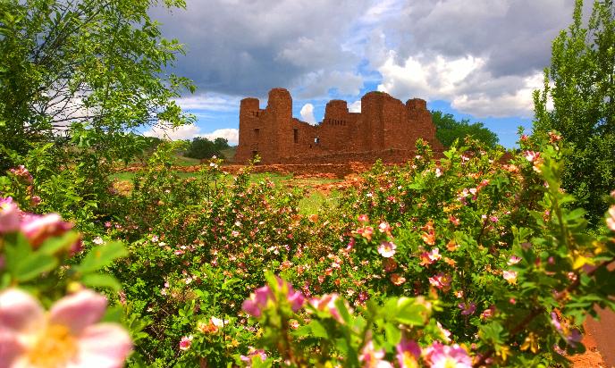
Salinas Pueblo Missions National Monument
National Monument
Tucked away in the middle of New Mexico you’ll find Salinas Pueblo Missions National Monument. Its three distinct sites offer a glimpse into a unique time in history—a time entrenched with cultural bo...
11 mi from route
~27 min detour
Free
near mile 208.3
Park data from the National Park Service API. Alerts update every 2 hours.
More Details
What kind of drive is this?
This is a highway-focused drive, with a 99% highway share, meaning you'll be on interstates and major US highways for nearly the entire 241.6-mile trip. The longest uninterrupted stretch is a significant 168.7 miles on I 25, so be prepared for extended periods of consistent speed limits. While the route uses a mix of I 25, US 60, and NM 41, the overall feel is one of efficient travel rather than winding backroads. Expect a consistent driving experience for most of the journey, punctuated by transitions between these main arteries.
99% highway — fuel and pacing are the main things to plan.
14 navigation steps total — most of the decisions cluster near the start and finish.
Longest single stretch: 168.7 mi on I 25.
How Hard Is This Drive?
4/10
This is a straightforward highway drive that stays mostly on I 25 and US 60. There are only a few real navigation decisions along the way. The trickiest moment comes around 0.1 miles in.
Driving Effort4/10
Easy - simple navigation with a manageable amount of wheel time
Balances navigation complexity with total wheel time.
This is a straightforward 4h 47m drive. You will face about 11 decision points, but nothing that requires special attention if you follow navigation.
Where does it get tricky?
The main spots that need attention: at 0.1 miles: Navigation decision point; at 0.1 miles (North Church Street): Navigation decision point; at 0.2 miles (NM 478 / North Main Street): Roundabout - know your exit number before entering.
Elevation Profile
High-altitude sections with notable climbs
6,285 ft3,910 ft
Total Climb
2,849 ft
Total Descent
612 ft
Highest Point
6,285 ft
~207.1 mi in
Elevation Range
2,376 ft
Notable High Points
4,214 ft at ~17.3 miles+112 ft prominence
5,016 ft at ~103.5 miles+78 ft prominence
6,285 ft at ~207.1 miles+164 ft prominence
Towns Mentioned on Route Signs
Based on OSRM destination-sign hints, not a full list of every settlement the road passes.
On the drive from Las Cruces, NM to McIntosh, NM, road signs begin pointing toward Mountainair along the way.
Las Cruces is a city in New Mexico. The name means "the crosses" in Spanish. It is the state's second largest city, with a population of over 111,000 (in 2020), and is the site of New Mexico State University.
Top landmarks
•Rio Grande Theatre — movie theater in Las Cruces, New Mexico, United States
•Mesilla Park Elementary School — school building in Las Cruces, New Mexico
•Mesilla Park Historic District — historic district in Las Cruces, New Mexico
The longest stretch is about 168.7 miles on I 25. The full list of main roads is in the Roads section above.
Yes — we found about 6 rest areas or service plazas within a short detour of the route (from OpenStreetMap). See the Rest Stops tab under Nearby Places for locations and mile markers. Plan to stretch, use the bathroom, and top off fluids every 2–3 hours on longer drives.
Yes, with realistic expectations. Build in a stop roughly every 2 hours, have snacks and activities ready, and check the Nearby Places tabs for kid-friendly stops along the way.
Mostly yes along the main roads, but rural stretches through NM can have sparse or no coverage. Before you leave, download offline Google Maps or Apple Maps for the route, and consider downloading music or podcasts instead of streaming. If you depend on data for navigation, keep a paper backup of the turn-by-turn directions.
The main spots that need attention: at 0.1 miles: Navigation decision point; at 0.1 miles (North Church Street): Navigation decision point; at 0.2 miles (NM 478 / North Main Street): Roundabout - know your exit number before entering.
Yes — Salinas Pueblo Missions National Monument. See the National Parks section for detour distances and tips on detours.
Possible but tiring. At 4.8 hours each way, an in-and-out day trip would put you behind the wheel for 9.6 hours — manageable with a long break at McIntosh, NM, but most travelers stay overnight.