Origin
John Day, OR
Night in John Day on Saturday
Local time
9:22 PM
PDT
Current temp
52°F
Unavailable
Live forecast
Compiled and reviewed by the US Trip Planner planning team at COD Solutions Oy · Last reviewed Apr 18, 2026 · Editorial standards
Drive Time
3h 17m
Distance
136.2 mi
219 km
Drive Score
8/10
Great drive
Same Day?
Yes, doable
Fuel Cost
$27
one way
EV Charging
Unknown
Estimated drive times based on typical traffic patterns. Actual times may vary with weather, construction, and real-time conditions.

John Day, OR
Photo Collections

Terrebonne, OR
Wikimedia Commons
John Day to Terrebonne is 136.2 miles and takes about 3 hours 17 minutes via Ochoco Highway and John Day Highway, with a fuel budget near $27 and enough daylight to finish in a day. This trip stays within Oregon, making it a straightforward drive between the Pacific Coast region's interior. Expect a turn-heavy local drive, so it's not a route for simply cruising. Plan for a single recommended day, offering flexibility for exploration or a relaxed pace.
Trip Pace
Same-day drive is realistic
A same-day return is realistic if you keep stops short.
Break Rhythm
1 planned break
A short stop every 2 to 3 hours is enough for this drive.
Midpoint
68.1 miles from John Day, OR
A natural place for your longest stop of the day , about 1h 38m into the drive .
| Road | Distance | Duration |
|---|---|---|
| Ochoco Highway | 69.1 mi | 1h 37m |
| John Day Highway | 34.8 mi | 50m |
| O'Neil Highway | 12.7 mi | 17m |
| Northeast Ochoco Highway | 7.1 mi | 10m |
| Northeast Smith Rock Way | 3.2 mi | 4m |
| Northeast 3rd Street | 2.5 mi | 4m |
| West Main Street | 1.7 mi | 2m |
| Northwest Smith Rock Way | 1.6 mi | 3m |
Step-by-step road directions between John Day, OR and Terrebonne, OR.
Start on US 26; US 395
Continue on US 26; US 395
Continue on US 26; US 395
Continue on US 26
Continue on US 26
Continue on US 26
Continue on US 26
Continue on US 26
Continue on US 26
Continue on US 26
Continue on US 26
Turn straight onto OR 126
Merge onto OR 126
Turn right onto OR 370
Turn right onto Lone Pine Road
Turn left onto Northwest Smith Rock Way
Continue on Northeast Smith Rock Way
Continue on Northwest Smith Rock Way
Turn right onto 11th Street
Arrive at destination
Given the 3 hour 17 minute duration, you can easily complete this drive in a single day. Departing in the morning will give you ample time to reach Terrebonne with daylight to spare. Since this is a shorter, turn-heavy route, flexibility is key; you can depart when you're ready. Keep an eye on your fuel gauge, as the $27 estimated cost is based on the 136.2 miles, and there's only one recommended stop, so plan accordingly, especially before the longest 69.1-mile stretch on Ochoco Highway.
Morning Departure
An early start around 7-8 AM gets you there with plenty of daylight left.
Evening Departure
A late afternoon start means arriving after dark. Morning is better.
This is a comfortable same-day trip.
Departure
Before you leave
Start with fuel, water, and navigation already sorted so the first hour feels easy.
First stop
Around 30 miles or 43m in
Use this first pause for coffee, a restroom break, and a quick traffic check ahead.
Halfway reset
Around 68.1 miles or 1h 38m in
This is the best place for your longest stop, a real meal, and a full fuel check.
Final approach
Final hour starts around 2h 40m
Traffic, exits, and arrival timing usually matter more near Terrebonne, OR than in the middle of the route.
Open the route before leaving John Day, OR so your first major turns are already loaded.
Leave with enough water and a charging cable within reach, not packed away.
Check your fuel range against the first long segment, especially if you are starting outside city service areas.
Day 1
Settle into the route from John Day, OR
This is one driving day of about 136.2 miles and 3h 17m.
Rest stops, refuel points, and overnight suggestions along this route.

Mid-route town
Meal stop
68 mi into the route
Best for: Lunch, fuel, and a longer reset
This sits close to the middle of the route, so it works well for the longest stop of the day.
A short stop after about 30 miles helps settle the day before fatigue starts building.
The midpoint is around 68.1 miles from John Day, OR, which is a good place for a longer meal and fuel stop.
Before the longest stretch
Fuel checkTop up before Ochoco Highway if your tank is already low. That segment runs about 69.1 miles.
These stop ideas are pacing suggestions — the exact town or exit can change with traffic, hotel plans, and fuel range.
5 decision points cluster between mile 117.3 and 136.1 — GPS handles the exact turns, but know they're coming. Your lane choice matters more than the turn itself.
Merge onto OR 126 / Ochoco Highway
Merge point - match speed before joining
Turn right onto OR 370 / O'Neil Highway
Navigation decision point
Turn right onto Lone Pine Road
Navigation decision point
Turn left onto Northwest Smith Rock Way
Navigation decision point
Turn right onto 11th Street
Navigation decision point
Regular Gas
$27.13 one way
$54.27 round trip
| Fuel Type | $/gal | One Way | Round Trip |
|---|---|---|---|
| midgrade | $5.36 | $28.71 | $57.43 |
| premium | $5.59 | $29.98 | $59.96 |
| diesel | $5.61 | $30.07 | $60.14 |
No toll roads detected on this route.
Estimated Trip Cost (one way, 1 person)
Fuel
$27
Meals
$25–$50
Total
$52–$77
Rough estimate based on US averages. Hotel $80–$140/night, meals $25–$50/day.
Estimated CO2 emission: 47.7 kg one way. Prices: EIA weekly data, 2026-04-13.
Driving Electric?
About $14 in charging · 0 stops · 67% less CO2
| Vehicle Type | kWh | Stops | DC Fast | Home Charge |
|---|---|---|---|---|
| Average EV | 40.9 | 0 | $14.30 | $6.54 |
| Efficient EV | 34.1 | 0 | $11.92 | $5.45 |
| EV Truck/SUV | 54.5 | 0 | $19.07 | $8.72 |
Gas CO2
48 kg
EV CO2
16 kg (67% less)
This trip is well within single-charge range for most EVs. No charging stops needed if you start fully charged.
DC fast charging avg $0.35/kWh. Home charging avg $0.16/kWh. US grid CO2: 0.39 kg/kWh.
Current conditions at both ends of the drive.
Origin
Night in John Day on Saturday
Local time
9:22 PM
PDT
Current temp
52°F
Unavailable
Destination
Night in Terrebonne on Saturday
Local time
9:22 PM
PDT
Current temp
34°F
Unavailable
Seasonal Notes
Summer travel usually means heavier construction, hotter rest stops, and busier weekend traffic around major cities.
Winter travel shortens daylight, so a route that looks manageable on paper can feel much longer after dark.
Holiday weekends tend to make both departure and arrival windows slower than the raw route time suggests.
Time zone
Origin and destination are on the same clock, so arrival timing is easier to judge at a glance.
Temperature spread
A meaningful temperature swing is a good cue to rethink layers, water, and how soon you want to arrive.
Road read
Use the two city cards together: check the sky where you start, then compare it with the local time and temperature at arrival.
Weather data from the National Weather Service. Conditions may change; check closer to your travel date.
Worth a detour if your schedule allows.
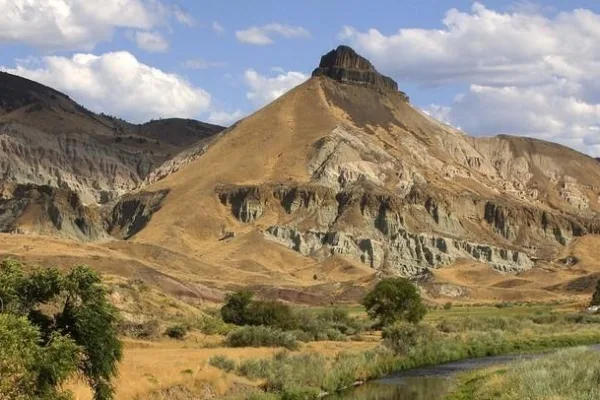
National Monument
Large rhino-like brontotheres roam a semitropical forest. Dog-sized, three-toed horses dart between the trees. The cat-like nimravid and bear dogs stalk their prey. The climate cools and forests alter...
Park data from the National Park Service API. Alerts update every 2 hours.
This route is characterized by its frequent turns, offering a dynamic driving experience rather than a monotonous interstate journey. With a 0% highway share, you'll primarily be on local roads, including stretches of Ochoco Highway and John Day Highway. The longest uninterrupted stretch spans 69.1 miles on Ochoco Highway, providing a good opportunity to settle into the drive before encountering more turns. The 'turn-heavy local drive' profile suggests you'll be actively navigating for much of the trip.
Expect a hands-on drive with frequent turns and local roads rather than long highway stretches. Navigation is very simple - set it and forget it for most of the drive. The trickiest moment comes around 117.3 miles in near OR 126 / Ochoco Highway.
Very easy - short and simple to drive
Balances navigation complexity with total wheel time.
The drive from John Day, OR to Terrebonne, OR is easy. At 3h 17m with 0% highway, most drivers will find it relaxed and low-stress.
Where does it get tricky?
The main spots that need attention: at 117.3 miles (OR 126 / Ochoco Highway): Merge point - match speed before joining; at 117.3 miles (OR 370 / O'Neil Highway): Navigation decision point; at 130.1 miles (Lone Pine Road): Navigation decision point.
Weekend Trip
Doable as a same-day drive at 3h 17m. Total distance: 136.2 miles.
Family Friendly
Moderate complexity with 1 natural rest stops along the way.
Solo Traveler
3h 17m drive, comfortable solo distance.
First-Time Driver
Mostly highway driving (0%). Straightforward navigation.
Scenic Drive
Mostly surface roads route profile with national parks nearby.
Compiled by the US Trip Planner planning team at COD Solutions Oy from open government datasets — OSRM over OpenStreetMap for geometry, EIA for fuel prices, and NPS for national parks. See our methodology for refresh cadence and limitations.
Was this helpful?
Thanks for your feedback!
Your tip has been submitted. Thanks!
/500
Recent Tips
·
Explore more options from John Day, OR or browse trips ending in Terrebonne, OR.
Looking for more statewide routes? Browse OR road trips.