This 248-mile journey from John Day, OR to Gresham, OR will take you approximately 6 hours of driving time. Planned as a single-day trip, it covers the Ochoco Highway, Warm Springs Highway, and Mount Hood Highway. The estimated fuel cost for this drive is around $49. Given its duration and the nature of the roads, it's a manageable day trip for most drivers. You'll be traveling entirely within the Pacific Coast region, staying within Oregon for the entire route.
Trip Pace
Same-day drive is realistic
A same-day return is possible, but it will make for a full day on the road.
Break Rhythm
1 planned break
Plan on a short reset every 3 to 4 hours to stay fresh behind the wheel.
Midpoint
124 miles from John Day, OR
A natural place for your longest stop of the day
, about 2h 58m into the drive
.
Main Roads
Road
Distance
Duration
Ochoco Highway
68.8 mi
1h 36m
Warm Springs Highway
46.7 mi
1h 4m
Mount Hood Highway
39.7 mi
57m
John Day Highway
34.8 mi
50m
Madras-Prineville Highway
26.2 mi
38m
Northwest Warm Springs Highway
13.3 mi
19m
Northeast Ochoco Highway
7.1 mi
10m
Northeast 3rd Street
2.5 mi
4m
Longest stretch:
Ochoco Highway
— 68.8 mi, about 1h 36m
Turn-by-Turn Driving Directions
Step-by-step road directions between John Day, OR and Gresham, OR.
1
Start on US 26; US 395
1.7 mi·2 min·West Main Street
2
Continue on US 26; US 395
6.3 mi·9 min·John Day Highway
3
Continue on US 26; US 395
0.4 mi·39 sec·East Main Street
4
Continue on US 26
22 mi·32 min·John Day Highway
5
Continue on US 26
1.1 mi·2 min·Franklin Street
6
Continue on US 26
6.3 mi·9 min·John Day Highway
7
Continue on US 26
69 mi·1 hr 36 min·Ochoco Highway
8
Continue on US 26
7.1 mi·10 min·Northeast Ochoco Highway
9
Continue on US 26
2.5 mi·4 min·Northeast 3rd Street
10
Continue on US 26
0.5 mi·43 sec·Northwest 3rd Street
11
Continue on US 26
373 ft·4 sec·Madras-Prineville Highway
12
Continue on US 26
26 mi·38 min·Madras-Prineville Highway
13
Turn right onto US 26; US 97
1.4 mi·3 min·The Dalles-California Highway
14
Continue on US 26; US 97
0.9 mi·2 min·5th Street
15
Continue on US 26
13 mi·19 min·Northwest Warm Springs Highway
Use the straight / right lanes.
16
Continue on US 26
47 mi·1 hr 4 min·Warm Springs Highway
17
Continue on US 26
31 mi·43 min·Mount Hood Highway
18
Continue on US 26
0.7 mi·2 min·Proctor Boulevard
19
Continue on US 26
9.1 mi·13 min·Mount Hood Highway
20
Continue on US 26
0.6 mi·58 sec·Southeast Mount Hood Highway
21
Turn slight left onto US 26
1.4 mi·3 min·East Powell Boulevard
Use the left lane.
22
Turn right
118 ft·8 sec
23
Arrive at destination
Trip Plan
To make the most of this 6-hour drive, consider an early morning departure from John Day to maximize daylight and allow for a leisurely pace. With only one recommended stop, you have flexibility in choosing where and when to rest. Keep an eye on your fuel levels, especially as you approach the longer 68.8-mile stretch on the Ochoco Highway, as services may be less frequent in some areas. This route is well-suited for a single day, so you can adjust your schedule as needed.
Morning Departure
Start early — leave by 6-7 AM to arrive at a reasonable hour.
Evening Departure
This is a long drive — plan for a morning departure or consider splitting it into two days.
You can normally do this drive in one day.
Plan roughly 1 meaningful break for fuel, food, and rest.
The halfway point lands around 124 miles from John Day, OR, or about 2h 58m into the drive.
The longest continuous stretch on this route runs about 68.8 miles.
This is a comfortable same-day trip.
Departure
Before you leave
Start with fuel, water, and navigation already sorted so the first hour feels easy.
First stop
Around 55 miles or 1h 20m in
Use this first pause for coffee, a restroom break, and a quick traffic check ahead.
Halfway reset
Around 124 miles or 2h 58m in
This is the best place for your longest stop, a real meal, and a full fuel check.
Final approach
Final hour starts around 4h 54m
Traffic, exits, and arrival timing usually matter more near Gresham, OR than in the middle of the route.
Before You Leave
+
Open the route before leaving John Day, OR so your first major turns are already loaded.
+
Leave with enough water and a charging cable within reach, not packed away.
+
Check your fuel range against the first long segment, especially if you are starting outside city service areas.
Day 1
Settle into the route from John Day, OR
This is one driving day of about 248 miles and 6h 1m.
Your first comfortable stop window is around 55 miles from John Day, OR.
This route can stay practical as a one-day drive if traffic stays reasonable.
Plan about 1 real break rather than only quick fuel stops.
The longest stretch is on Ochoco Highway for about 68.8 miles.
Where to Stop
Rest stops, refuel points, and overnight suggestions along this route.
Place data sourced from public business listings. Hours and availability may vary.
Heads-up: tricky spots
3 of 3
3 decision points cluster between mile 143.2 and 248 — GPS handles the exact turns, but know they're coming. Your lane choice matters more than the turn itself.
3
143.2 mi into trip|~3h 27m in|US 26; US 97 / The Dalles-California Highway
Turn right onto US 26; US 97 / The Dalles-California Highway
Navigation decision point
3
246.6 mi into trip|~5h 57m in|US 26 / East Powell Boulevard
Turn slight left onto US 26 / East Powell Boulevard
Lane positioning matters here
Use the left lane.
4
248 mi into trip|~6h 1m in
Turn right
Navigation decision point
Fuel & Cost
Regular Gas
$43.95 one way
$87.89 round trip
$4.50/gal25.4 MPG avg87 kg CO2
Fuel Type
$/gal
One Way
Round Trip
midgrade
$4.82
$47.06
$94.12
premium
$5.04
$49.23
$98.46
diesel
$4.80
$46.83
$93.65
No toll roads detected on this route.
Estimated Trip Cost (one way, 1 person)
Fuel
$44
Meals
$25–$50
Total
$69–$94
Rough estimate based on US averages. Hotel $80–$140/night, meals $25–$50/day.
Estimated CO2 emission: 86.8 kg one way.
Prices: EIA weekly data, 2026-07-13.
Driving Electric?
About $26 in charging
· 0 stops
· 67% less CO2
Vehicle Type
kWh
Stops
DC Fast
Home Charge
Average EV
74.4
0
$26.04
$11.90
Efficient EV
62
0
$21.70
$9.92
EV Truck/SUV
99.2
1
$34.72
$15.87
Gas CO2
87 kg
EV CO2
29 kg (67% less)
Plan for 0 charging stops, roughly every 270 miles. Allow 25-40 minutes per stop at a DC fast charger.
DC fast charging avg $0.35/kWh. Home charging avg $0.16/kWh. US grid CO2: 0.39 kg/kWh.
Travel Intel
Current conditions at both ends of the drive.
Forecast as of Jul 18, 2026
Origin
John Day, OR
Late night
in John Day on Sunday
Local time
1:19 AM
PDT
Current temp
53°F
Areas Of Smoke
SE 2 mph0% chanceLive forecast
Red Flag Warning
Red Flag Warning issued July 18 at 4:30AM PDT until July 18 at 10:00PM PDT by NWS Pendleton OR
Destination
Gresham, OR
Late night
in Gresham on Sunday
Local time
1:19 AM
PDT
Current temp
54°F
Mostly Clear
NW 2 mph0% chanceLive forecast
Red Flag Warning
Red Flag Warning issued July 18 at 4:30AM PDT until July 18 at 10:00PM PDT by NWS Pendleton OR
90°F
Redmond, OR
124 mi in
Seasonal Notes
Summer travel usually means heavier construction, hotter rest stops, and busier weekend traffic around major cities.
Winter travel shortens daylight, so a route that looks manageable on paper can feel much longer after dark.
Holiday weekends tend to make both departure and arrival windows slower than the raw route time suggests.
Time zone
Same local time
Origin and destination are on the same clock, so arrival timing is easier to judge at a glance.
Temperature spread
1 degrees warmer at arrival
A meaningful temperature swing is a good cue to rethink layers, water, and how soon you want to arrive.
Road read
6h 1m on the road
Start early — leave by 6-7 AM to arrive at a reasonable hour.
Weather data from the National Weather Service. Conditions may change; check closer to your travel date.
National Parks Near This Route
Worth a detour if your schedule allows.
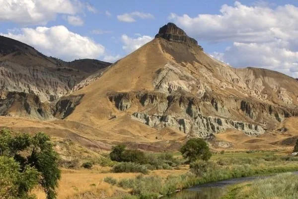
John Day Fossil Beds National Monument
National Monument
Large rhino-like brontotheres roam a semitropical forest. Dog-sized, three-toed horses dart between the trees. The cat-like nimravid and bear dogs stalk their prey. The climate cools and forests alter...
5 mi from route
~12 min detour
Free
near mile 51.3
Park data from the National Park Service API. Alerts update every 2 hours.
More Details
What kind of drive is this?
Expect a turn-heavy local drive on this route, with no highway mileage. The longest continuous stretch you'll encounter is 68.8 miles on the Ochoco Highway. This road profile suggests a more engaging driving experience, likely involving winding sections and potentially varying speed limits as you navigate local roads. You'll experience a dynamic route that keeps you actively involved behind the wheel.
Only 0% highway — the rest is turn-by-turn surface driving.
23 navigation steps total — most of the decisions cluster near the start and finish.
Longest single stretch: 68.8 mi on Ochoco Highway.
How Hard Is This Drive?
3/10
Expect a hands-on drive with frequent turns and local roads rather than long highway stretches. There are only a few real navigation decisions along the way. The trickiest moment comes around 143.2 miles in near US 26; US 97 / The Dalles-California Highway.
Driving Effort3/10
Easy - simple navigation with a manageable amount of wheel time
Balances navigation complexity with total wheel time.
The route itself is not hard, but at 6h 1m, endurance matters. Plan breaks every 2-3 hours. The 3 decision points are all manageable with basic attention.
Where does it get tricky?
The main spots that need attention: at 143.2 miles (US 26; US 97 / The Dalles-California Highway): Navigation decision point; at 246.6 miles (US 26 / East Powell Boulevard): Lane positioning matters here; at 248 miles: Navigation decision point.
Gresham is the fourth largest city within the state of Oregon, with a population of 114,000 in 2020. It's the home of an annual jazz festival. It is a part of the Portland Metropolitan Area and is generally considered a Portland suburb.
The downtown area of Gresham can be easily missed by those driving along W Powell Blvd, but has a handful of restaurants and shops to offer, as well as Main City Park.
Top landmarks
•Charles and Fae Olson House — historic house in Gresham, Oregon, USA
•Dr. Herbert H. Hughes House — historic house in Gresham, Oregon, USA
•Emanuel and Christina Anderson House — historic house in Gresham, Oregon, USA
Mostly surface roads route profile with national parks nearby.
Frequently Asked Questions
The longest stretch is about 68.8 miles on Ochoco Highway. The full list of main roads is in the Roads section above.
Yes — we found about 4 rest areas or service plazas within a short detour of the route (from OpenStreetMap). See the Rest Stops tab under Nearby Places for locations and mile markers. Plan to stretch, use the bathroom, and top off fluids every 2–3 hours on longer drives.
It helps. This is a long drive, so arriving tired and in the dark compounds. If the last hour of the trip is on surface roads or mountain grades, aim to arrive at Gresham, OR before sunset when you can. Check the Trip Plan for departure windows that land you in daylight.
Only with planning. This is a long drive for kids — consider splitting it into two days rather than pushing through. Plan at least 1 meaningful breaks. There are 4 rest areas along the route for bathroom stops.
The main spots that need attention: at 143.2 miles (US 26; US 97 / The Dalles-California Highway): Navigation decision point; at 246.6 miles (US 26 / East Powell Boulevard): Lane positioning matters here; at 248 miles: Navigation decision point.
Yes — John Day Fossil Beds National Monument. See the National Parks section for detour distances and tips on detours.
Not recommended in a single day. At 6.0 hours each way, a round trip means 12.0 hours of driving — that is an unsafe level of fatigue for most drivers. Plan at least one night at Gresham, OR before the return drive.