Traveling from Jacksonville to Magnolia, Arkansas, covers a 153.1-mile stretch that typically takes about 3 hours and 5 minutes behind the wheel. Because this is a relatively straightforward drive through the state’s Southeast region, it is perfectly suited for a single-day trip without the need for an overnight stay. You can expect to spend roughly $23 on fuel for the journey, making it a budget-friendly option for your itinerary. The route relies primarily on a combination of I-30, US 278, and US 371 to get you to your destination efficiently. Whether you are heading out for business or a quick getaway, this drive offers a reliable path across the Arkansas landscape.
Trip Pace
Same-day drive is realistic
A same-day return is realistic if you keep stops short.
Break Rhythm
1 planned break
A short stop every 2 to 3 hours is enough for this drive.
Midpoint
76.5 miles from Jacksonville, AR
A natural place for your longest stop of the day
, about 1h 25m into the drive
.
Main Roads
Road
Distance
Duration
I 30
91.7 mi
1h 34m
US 278
17.9 mi
26m
US 371
17 mi
25m
I 57
8.8 mi
9m
East McKissack
7.2 mi
10m
US 167
4.9 mi
6m
Delight Highway
2.4 mi
4m
West Main Street
1.1 mi
3m
Longest stretch:
I 30
— 91.7 mi, about 1h 34m
Turn-by-Turn Driving Directions
Step-by-step road directions between Jacksonville, AR and Magnolia, AR.
1
Start on AR 161
188 ft·7 sec·North 1st Street
2
Turn left onto West Hickory Street
333 ft·20 sec·West Hickory Street
3
Turn left onto North 2nd Street
362 ft·20 sec·North 2nd Street
4
Turn right onto West Main Street
1.0 mi·3 min·West Main Street
5
Take the ramp
0.2 mi·24 sec
6
Merge onto I 57; US 167
8.8 mi·9 min·I 57; US 167
7
Merge onto I 40; US 167
0.9 mi·1 min·I 40; US 167
8
Take the exit onto US 167
4.9 mi·6 min·US 167
Toward I 30 West, US 65 South, US 67 South, US 167 South: Little Rock
9
Keep slight right at fork onto I 30; US 67
24 mi·26 min·I 30; US 67
Exit 138Toward TexarkanaUse the slight left / slight right lanes.
10
Continue on I 30; US 70
68 mi·1 hr 7 min·I 30; US 70
11
Take the exit
0.3 mi·38 sec
Toward AR 19: Prescott
12
Turn left onto AR 19
2.4 mi·4 min·Delight Highway
13
Turn right onto US 67; US 371
0.4 mi·39 sec·West 1st Street South
14
Turn right onto US 371
17 mi·25 min·US 371
15
At end of road, turn left onto US 278; US 371
18 mi·26 min·US 278; US 371
16
Turn left onto US 371
7.2 mi·10 min·East McKissack
17
Turn left onto West Main Street
0.1 mi·12 sec·West Main Street
18
Enter roundabout onto East Main Street
443 ft·10 sec·East Main Street
19
Continue on East Main Street
326 ft·9 sec·East Main Street
20
Turn right onto US 79B; AR 19
10 ft·0 sec·Jackson Street
21
Arrive at destination
US 79B; AR 19
Trip Plan
To make the most of your 3-hour journey, plan for at least one dedicated stop to stretch your legs and refresh. Since this is a manageable drive, you have the flexibility to depart whenever fits your schedule best, though leaving mid-morning can help you avoid any potential peak traffic on the interstate segments. Keep a close eye on your fuel gauge during the final leg on US 371, as services may become less frequent compared to the I-30 corridor. Having your $23 fuel budget set aside before you start will keep your travel logistics simple. Use the longest stretch on I-30 to settle into a comfortable rhythm, but stay alert for the transition onto the secondary highways as you approach Magnolia.
Morning Departure
An early start around 7-8 AM gets you there with plenty of daylight left.
Evening Departure
A late afternoon start means arriving after dark. Morning is better.
You can normally do this drive in one day.
Plan roughly 1 meaningful break for fuel, food, and rest.
The halfway point lands around 76.5 miles from Jacksonville, AR, or about 1h 25m into the drive.
The longest continuous stretch on this route runs about 91.7 miles.
This is a comfortable same-day trip.
Departure
Before you leave
Start with fuel, water, and navigation already sorted so the first hour feels easy.
First stop
Around 34 miles or 41m in
Use this first pause for coffee, a restroom break, and a quick traffic check ahead.
Halfway reset
Around 76.5 miles or 1h 25m in
This is the best place for your longest stop, a real meal, and a full fuel check.
Final approach
Final hour starts around 2h 23m
Traffic, exits, and arrival timing usually matter more near Magnolia, AR than in the middle of the route.
Before You Leave
+
Open the route before leaving Jacksonville, AR so your first major turns are already loaded.
+
Leave with enough water and a charging cable within reach, not packed away.
+
Check your fuel range against the first long segment, especially if you are starting outside city service areas.
Day 1
Settle into the route from Jacksonville, AR
This is one driving day of about 153.1 miles and 3h 5m.
Your first comfortable stop window is around 34 miles from Jacksonville, AR.
This route can stay practical as a one-day drive if traffic stays reasonable.
Plan about 1 real break rather than only quick fuel stops.
The longest stretch is on I 30 for about 91.7 miles.
Where to Stop
Rest stops, refuel points, and overnight suggestions along this route.
Place data sourced from public business listings. Hours and availability may vary.
Heads-up: tricky spots
5 of 18
5 decision points cluster between mile 0 and 152.9 — GPS handles the exact turns, but know they're coming. Your lane choice matters more than the turn itself.
4
0 mi into trip|~0m in|West Hickory Street
Turn left onto West Hickory Street
Navigation decision point
5
0.1 mi into trip|~0m in|North 2nd Street
Turn left onto North 2nd Street
Navigation decision point
5
11.1 mi into trip|~15m in|US 167
Take the exit onto US 167 toward I 30 West, US 65 South, US 67 South, US 167 South: Little Rock
Exit ramp - move to the correct lane early. Multiple destination signs - pick the right one
Toward I 30 West, US 65 South, US 67 South, US...
8
16 mi into trip|~21m in|I 30; US 67
Keep slight right at fork onto I 30; US 67 toward Texarkana
Highway fork - watch signs carefully. Lane positioning matters here
Use the slight left / slight right lanes.
Exit 138
Toward Texarkana
7
152.9 mi into trip|~3h 4m in|East Main Street
Enter roundabout onto East Main Street
Roundabout - know your exit number before entering
Fuel & Cost
Regular Gas
$23.12 one way
$46.24 round trip
$3.84/gal25.4 MPG avg54 kg CO2
Fuel Type
$/gal
One Way
Round Trip
midgrade
$4.21
$25.38
$50.76
premium
$4.56
$27.48
$54.96
diesel
$5.61
$33.80
$67.61
No toll roads detected on this route.
Estimated Trip Cost (one way, 1 person)
Fuel
$23
Meals
$25–$50
Total
$48–$73
Rough estimate based on US averages. Hotel $80–$140/night, meals $25–$50/day.
Estimated CO2 emission: 53.6 kg one way.
Prices: EIA weekly data, 2026-04-13.
Driving Electric?
About $16 in charging
· 0 stops
· 67% less CO2
Vehicle Type
kWh
Stops
DC Fast
Home Charge
Average EV
45.9
0
$16.08
$7.35
Efficient EV
38.3
0
$13.40
$6.12
EV Truck/SUV
61.2
0
$21.43
$9.80
Gas CO2
54 kg
EV CO2
18 kg (67% less)
This trip is well within single-charge range for most EVs. No charging stops needed if you start fully charged.
DC fast charging avg $0.35/kWh. Home charging avg $0.16/kWh. US grid CO2: 0.39 kg/kWh.
Travel Intel
Current conditions at both ends of the drive.
Forecast as of Apr 15, 2026
Origin
Jacksonville, AR
Night
in Jacksonville on Saturday
Local time
11:37 PM
CDT
Current temp
77°F
Unavailable
Live forecast
Destination
Magnolia, AR
Night
in Magnolia on Saturday
Local time
11:37 PM
CDT
Current temp
76°F
Unavailable
Live forecast
Seasonal Notes
Summer travel usually means heavier construction, hotter rest stops, and busier weekend traffic around major cities.
Winter travel shortens daylight, so a route that looks manageable on paper can feel much longer after dark.
Holiday weekends tend to make both departure and arrival windows slower than the raw route time suggests.
Time zone
Same local time
Origin and destination are on the same clock, so arrival timing is easier to judge at a glance.
Temperature spread
1 degrees cooler at arrival
A meaningful temperature swing is a good cue to rethink layers, water, and how soon you want to arrive.
Road read
3h 5m on the road
Use the two city cards together: check the sky where you start, then compare it with the local time and temperature at arrival.
Weather data from the National Weather Service. Conditions may change; check closer to your travel date.
National Parks Near This Route
Worth a detour if your schedule allows.
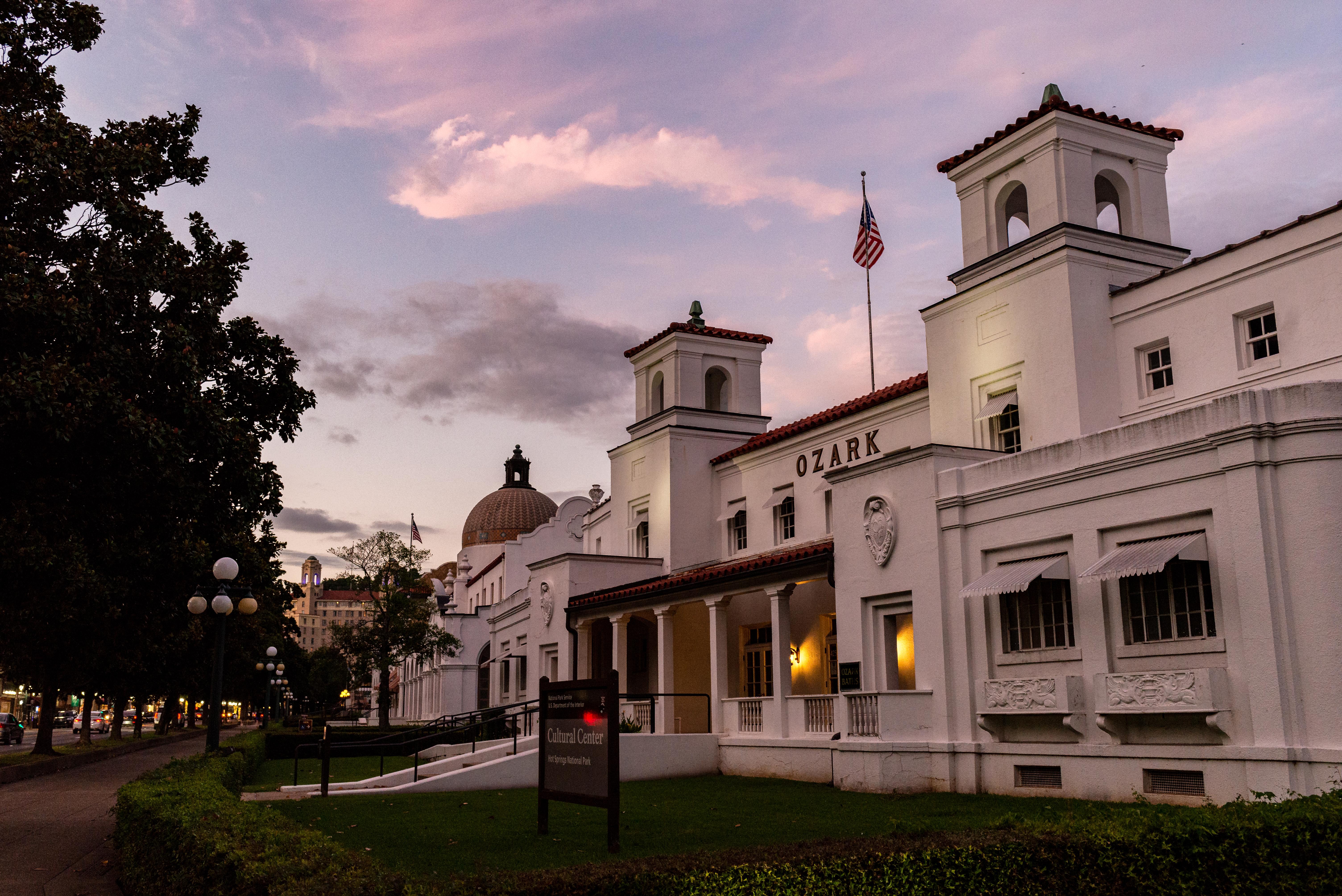
Hot Springs National Park
National Park
Hot Springs National Park has a rich cultural past. The grand architecture of our historic bathhouses is equally matched by the natural curiosities that have been drawing people here for hundreds of y...
16 mi from route
~39 min detour
Free
near mile 63.3
Park data from the National Park Service API. Alerts update every 2 hours.
More Details
What kind of drive is this?
This trip is heavily highway-focused, with 92% of your travel occurring on major thoroughfares. You will spend the bulk of your time on I-30, which accounts for a 91.7-mile stretch of the journey. Expect a steady, high-speed pace for the majority of the drive as you navigate these primary arteries. Transitioning from the interstate onto US 278 and US 371 will shift the driving experience from a wide-lane grind to a more standard regional highway feel. While the interstate portion allows for consistent cruising, remain attentive as the road transitions through the final segments of the route.
92% highway — fuel and pacing are the main things to plan.
21 navigation steps total — most of the decisions cluster near the start and finish.
Longest single stretch: 91.7 mi on I 30.
How Hard Is This Drive?
4/10
This is a straightforward highway drive that stays mostly on I 30 and US 278. There are only a few real navigation decisions along the way. The trickiest moment comes early in the drive near West Hickory Street.
Driving Effort4/10
Easy - simple navigation with a manageable amount of wheel time
Balances navigation complexity with total wheel time.
This is a straightforward 3h 5m drive. You will face about 18 decision points, but nothing that requires special attention if you follow navigation.
Where does it get tricky?
The main spots that need attention: near the start (West Hickory Street): Navigation decision point; at 0.1 miles (North 2nd Street): Navigation decision point; at 11.1 miles (US 167): Exit ramp - move to the correct lane early. Multiple destination signs - pick the right one.
Elevation Profile
Mostly flat terrain
446 ft238 ft
Total Climb
381 ft
Total Descent
331 ft
Highest Point
446 ft
~43.7 mi in
Elevation Range
208 ft
Towns Mentioned on Route Signs
Based on OSRM destination-sign hints, not a full list of every settlement the road passes.
On the drive from Jacksonville, AR to Magnolia, AR, road signs begin pointing toward Texarkana along the way.
The longest stretch is about 91.7 miles on I 30. The full list of main roads is in the Roads section above.
We did not find dedicated rest areas on this route. For a drive this long, plan bathroom and stretch breaks around gas stations, fast-food stops, or small-town downtowns — check the Nearby Places section for options.
Yes, with realistic expectations. Build in a stop roughly every 2 hours, have snacks and activities ready, and check the Nearby Places tabs for kid-friendly stops along the way.
The main spots that need attention: near the start (West Hickory Street): Navigation decision point; at 0.1 miles (North 2nd Street): Navigation decision point; at 11.1 miles (US 167): Exit ramp - move to the correct lane early. Multiple destination signs - pick the right one.
Yes — Hot Springs National Park. See the National Parks section for detour distances and tips on detours.
Possible but tiring. At 3.1 hours each way, an in-and-out day trip would put you behind the wheel for 6.2 hours — manageable with a long break at Magnolia, AR, but most travelers stay overnight.