Jackson, MS to Arnold Line, MS is 90.2 miles and takes about 1h 54m via Highway 49 South, with a fuel budget near $14 and enough daylight to finish in a day. This trip stays entirely within Mississippi, traversing the Southeast region. It's a straightforward drive primarily on a major highway, making it a convenient option if you need to cover this distance efficiently. You'll find it to be a practical route for a single-day journey, with minimal fuss and a predictable travel time.
Trip Pace
Same-day drive is realistic
A same-day return is realistic if you keep stops short.
Midpoint
45.1 miles from Jackson, MS
A natural place for your longest stop of the day
, about 57m into the drive
.
Main Roads
Road
Distance
Duration
Highway 49 South
80.3 mi
1h 37m
US 49
2.2 mi
3m
Lance Corporal Roy M Wheat Memorial Highway
1.9 mi
1m
West 4th Street
1 mi
2m
Westover Drive
0.9 mi
2m
I 55
0.8 mi
1m
East Pascagoula Street
0.5 mi
1m
East Pearl Street
<0.1 mi
<1m
Longest stretch:
Highway 49 South
— 80.3 mi, about 1h 37m
Turn-by-Turn Driving Directions
Step-by-step road directions between Jackson, MS and Arnold Line, MS.
1
Start on East Pearl Street
443 ft·15 sec·East Pearl Street
2
Turn left onto South Lamar Street
372 ft·17 sec·South Lamar Street
3
Turn left onto East Pascagoula Street
0.5 mi·1 min·East Pascagoula Street
4
Take the ramp
0.5 mi·1 min
5
Keep slight right at fork
0.3 mi·44 sec
6
Merge onto I 55
0.8 mi·1 min·I 55
7
Take the exit
0.9 mi·1 min
Toward I 20 East, US 49 South: Meridian, Hattiesburg
8
Keep slight right at fork onto US 49
0.7 mi·1 min·US 49
Toward Richland, Hattiesburg
9
Merge onto US 49
80 mi·1 hr 37 min·Highway 49 South
Use the straight lane.
10
Continue on US 49; MS 42
0.4 mi·35 sec·US 49; MS 42
Use the straight lane.
11
Continue on US 49; MS 42
1.1 mi·1 min·US 49; MS 42
Use the straight lane.
12
Take the exit
0.4 mi·36 sec
Toward I 59 South: New Orleans, Gulf CoastUse the slight right lane.
13
Merge onto I 59
1.9 mi·1 min·Lance Corporal Roy M Wheat Memorial Highway
Toward Mississippi Gulf Coast
14
Take the exit
0.2 mi·21 sec
Toward US 98 West: Columbia, Hardy StreetUse the slight right lane.
15
Keep slight right at fork
0.1 mi·13 sec
Toward North Westover Drive
16
Merge onto US 98
341 ft·6 sec·Hardy Street
17
Turn right onto Westover Drive
0.9 mi·2 min·Westover Drive
18
Turn left onto West 4th Street
1.0 mi·2 min·West 4th Street
19
Turn right onto Brand Lane
113 ft·4 sec·Brand Lane
20
Arrive at destination
Brand Lane
Trip Plan
Given the relatively short duration of 1 hour and 54 minutes, this trip is easily completed in a single day, allowing for flexibility in your departure time. With only 90.2 miles to cover, you can afford to leave later in the morning or early afternoon. The longest stretch without a break is over 80 miles, so consider a brief stop for fuel or a stretch before you begin if you prefer not to drive that far continuously. Keep an eye on your fuel gauge, as services can sometimes be spread out on these longer highway segments.
Morning Departure
Leave by 9 AM and you'll arrive before lunch.
Evening Departure
Even a 4 PM departure gets you there before dark in summer.
You can normally do this drive in one day.
You may only need one short stretch break if traffic stays light.
The halfway point lands around 45.1 miles from Jackson, MS, or about 57m into the drive.
The longest continuous stretch on this route runs about 80.3 miles.
This is a comfortable same-day trip.
Departure
Before you leave
Start with fuel, water, and navigation already sorted so the first hour feels easy.
First stop
Around 20 miles or 26m in
Use this first pause for coffee, a restroom break, and a quick traffic check ahead.
Halfway reset
Around 45.1 miles or 57m in
This is the best place for your longest stop, a real meal, and a full fuel check.
Final approach
Final hour starts around 1h 32m
Traffic, exits, and arrival timing usually matter more near Arnold Line, MS than in the middle of the route.
Before You Leave
+
Open the route before leaving Jackson, MS so your first major turns are already loaded.
Day 1
Settle into the route from Jackson, MS
This is one driving day of about 90.2 miles and 1h 54m.
Your first comfortable stop window is around 20 miles from Jackson, MS.
This route can stay practical as a one-day drive if traffic stays reasonable.
The longest stretch is on Highway 49 South for about 80.3 miles.
Where to Stop
Rest stops, refuel points, and overnight suggestions along this route.
Place data sourced from public business listings. Hours and availability may vary.
Heads-up: tricky spots
5 of 15
5 decision points cluster between mile 2.3 and 88.1 — GPS handles the exact turns, but know they're coming. Your lane choice matters more than the turn itself.
5
2.3 mi into trip|~4m in
Take the exit toward I 20 East, US 49 South: Meridian, Hattiesburg
Exit ramp - move to the correct lane early. Multiple destination signs - pick the right one
Toward I 20 East, US 49 South: Meridian, Hattie...
6
3.2 mi into trip|~5m in|US 49
Keep slight right at fork onto US 49 toward Richland, Hattiesburg
Highway fork - watch signs carefully. Multiple destination signs - pick the right one
Toward Richland, Hattiesburg
7
85.7 mi into trip|~1h 46m in
Take the exit toward I 59 South: New Orleans, Gulf Coast
Exit ramp - move to the correct lane early. Lane positioning matters here. Multiple destination signs - pick the right one
Use the slight right lane.
Toward I 59 South: New Orleans, Gulf Coast
7
87.9 mi into trip|~1h 49m in
Take the exit toward US 98 West: Columbia, Hardy Street
Exit ramp - move to the correct lane early. Lane positioning matters here. Multiple destination signs - pick the right one
Use the slight right lane.
Toward US 98 West: Columbia, Hardy Street
6
88.1 mi into trip|~1h 49m in
Keep slight right at fork toward North Westover Drive
Highway fork - watch signs carefully
Toward North Westover Drive
Fuel & Cost
Regular Gas
$13.62 one way
$27.24 round trip
$3.84/gal25.4 MPG avg32 kg CO2
Fuel Type
$/gal
One Way
Round Trip
midgrade
$4.21
$14.95
$29.91
premium
$4.56
$16.19
$32.38
diesel
$5.61
$19.92
$39.83
No toll roads detected on this route.
Estimated Trip Cost (one way, 1 person)
Fuel
$14
Meals
$25–$50
Total
$39–$64
Rough estimate based on US averages. Hotel $80–$140/night, meals $25–$50/day.
Estimated CO2 emission: 31.6 kg one way.
Prices: EIA weekly data, 2026-04-13.
Driving Electric?
About $9 in charging
· 0 stops
· 66% less CO2
Vehicle Type
kWh
Stops
DC Fast
Home Charge
Average EV
27.1
0
$9.47
$4.33
Efficient EV
22.6
0
$7.89
$3.61
EV Truck/SUV
36.1
0
$12.63
$5.77
Gas CO2
32 kg
EV CO2
11 kg (66% less)
This trip is well within single-charge range for most EVs. No charging stops needed if you start fully charged.
DC fast charging avg $0.35/kWh. Home charging avg $0.16/kWh. US grid CO2: 0.39 kg/kWh.
Travel Intel
Current conditions at both ends of the drive.
Forecast as of Apr 18, 2026
Origin
Jackson, MS
Late night
in Jackson on Sunday
Local time
2:54 AM
CDT
Current temp
63°F
Partly Cloudy
SSW 5 mph0% chanceLive forecast
Destination
Arnold Line, MS
Late night
in Arnold Line on Sunday
Local time
2:54 AM
CDT
Current temp
59°F
Unavailable
Live forecast
Seasonal Notes
Summer travel usually means heavier construction, hotter rest stops, and busier weekend traffic around major cities.
Winter travel shortens daylight, so a route that looks manageable on paper can feel much longer after dark.
Holiday weekends tend to make both departure and arrival windows slower than the raw route time suggests.
Time zone
Same local time
Origin and destination are on the same clock, so arrival timing is easier to judge at a glance.
Temperature spread
4 degrees cooler at arrival
A meaningful temperature swing is a good cue to rethink layers, water, and how soon you want to arrive.
Road read
1h 54m on the road
The weather snapshot is not static. If you are leaving later, give both cities one more quick forecast check before departure.
Weather data from the National Weather Service. Conditions may change; check closer to your travel date.
National Parks Near This Route
Worth a detour if your schedule allows.
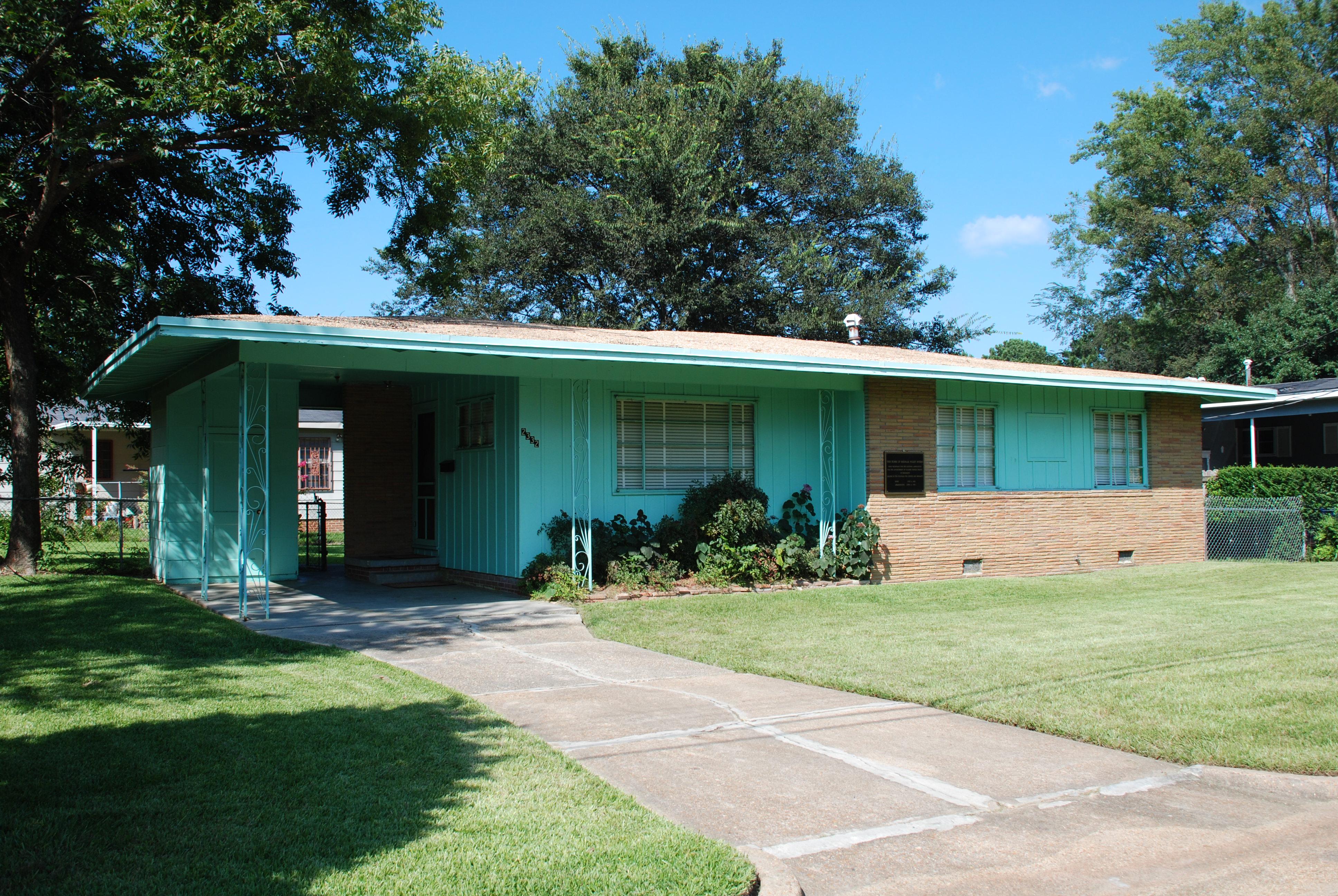
Medgar and Myrlie Evers Home National Monument
National Monument
Medgar and Myrlie Evers were partners in the civil rights struggle. The assassination of Medgar Evers in the carport of their home on June 12, 1963, was the first murder of a nationally significant le...
Park data from the National Park Service API. Alerts update every 2 hours.
More Details
What kind of drive is this?
This route is predominantly a highway-focused drive, with 92% of the journey on major roadways. Expect long stretches of consistent speed, including an uninterrupted segment of 80.3 miles on Highway 49 South. The Lance Corporal Roy M Wheat Memorial Highway is also part of this route, offering a familiar highway experience. The character of the drive is largely defined by these main arteries, providing a predictable and steady pace for most of your travel time.
92% highway — fuel and pacing are the main things to plan.
20 navigation steps total — most of the decisions cluster near the start and finish.
Longest single stretch: 80.3 mi on Highway 49 South.
How Hard Is This Drive?
10/10
This is a straightforward highway drive that stays mostly on Highway 49 South and US 49. This route has several spots where lane changes, forks, or exits need your full attention. The trickiest moment comes around 2.3 miles in.
Driving Effort10/10
Demanding - stay alert through the decision-heavy sections
Balances navigation complexity with total wheel time.
This drive requires moderate attention. Across 90.2 miles you will encounter 15 spots where lane choice or exit timing matters. Not difficult for experienced highway drivers, but worth previewing the tricky sections before you go.
Where does it get tricky?
The main spots that need attention: at 2.3 miles: Exit ramp - move to the correct lane early. Multiple destination signs - pick the right one; at 3.2 miles (US 49): Highway fork - watch signs carefully. Multiple destination signs - pick the right one; at 85.7 miles: Exit ramp - move to the correct lane early. Lane positioning matters here. Multiple destination signs - pick the right one.
Who Is This Route For?
Weekend Trip
Doable as a same-day drive at 1h 54m. Total distance: 90.2 miles.
Family Friendly
Moderate complexity with 0 natural rest stops along the way.
Solo Traveler
1h 54m drive, comfortable solo distance.
First-Time Driver
Mostly highway driving (92%). Some complex stretches to watch for.
Frequently Asked Questions
The longest stretch is about 80.3 miles on Highway 49 South. The full list of main roads is in the Roads section above.
It helps. This route has a higher-than-average number of complex decision points, which get harder in the dark. If the last hour of the trip is on surface roads or mountain grades, aim to arrive at Arnold Line, MS before sunset when you can. Check the Trip Plan for departure windows that land you in daylight.
Yes. At under 2 hours behind the wheel, this works well for families — plan one quick stop if you have younger kids.
The main spots that need attention: at 2.3 miles: Exit ramp - move to the correct lane early. Multiple destination signs - pick the right one; at 3.2 miles (US 49): Highway fork - watch signs carefully. Multiple destination signs - pick the right one; at 85.7 miles: Exit ramp - move to the correct lane early. Lane positioning matters here. Multiple destination signs - pick the right one.
Yes — Medgar and Myrlie Evers Home National Monument. See the National Parks section for detour distances and tips on detours.
Yes. A round trip is manageable in a single day if you plan a break at Arnold Line, MS before heading back.