This 292.8-mile drive from Helper, UT to Saint George, UT is a solid day trip, estimated to take about 5 hours and 22 minutes. It's a mixed drive, meaning you'll experience a variety of road types along the way. With a fuel cost estimated at $46, this route offers a straightforward journey across Utah's diverse landscapes. Given the manageable duration and distance, you can comfortably complete this trip in one day, allowing for flexibility in your schedule. The route stays within the Mountain West region, offering a consistent feel throughout.
Trip Pace
Same-day drive is realistic
A same-day return is possible, but it will make for a full day on the road.
Break Rhythm
1 planned break
Plan on a short reset every 3 to 4 hours to stay fresh behind the wheel.
Midpoint
146.4 miles from Helper, UT
A natural place for your longest stop of the day
, about 2h 57m into the drive
.
Main Roads
Road
Distance
Duration
Veterans Memorial Highway
122.6 mi
1h 56m
I 70
90.4 mi
1h 27m
South Carbon Avenue
67.7 mi
1h 38m
Dinosaur Diamond Prehistoric Highway
7.4 mi
8m
Trailblazer Boulevard
0.9 mi
2m
I 15 BUS
0.8 mi
2m
University Avenue
0.5 mi
1m
Poplar Street
0.2 mi
<1m
Longest stretch:
Veterans Memorial Highway
— 122.6 mi, about 1h 56m
Turn-by-Turn Driving Directions
Step-by-step road directions between Helper, UT and Saint George, UT.
1
Start on US 6 BUS; US 191 BUS
0.1 mi·12 sec·South Main Street
2
Turn right onto SR 157; US 6 BUS; US 191 BUS
0.2 mi·20 sec·Poplar Street
3
Take the ramp
0.2 mi·22 sec
Toward US 6, US 191
4
Merge onto US 6; US 191
7.4 mi·8 min·Dinosaur Diamond Prehistoric Highway
5
Take the exit
0.4 mi·54 sec
6
Turn right onto SR 10
68 mi·1 hr 38 min·South Carbon Avenue
7
Take the ramp
0.5 mi·1 min
Toward I 70 West: Salina
8
Merge onto I 70; US 50
90 mi·1 hr 27 min·I 70; US 50
9
Keep slight left at fork
1.2 mi·2 min
Toward I 15 South: Las Vegas
10
Merge onto I 15
123 mi·1 hr 56 min·Veterans Memorial Highway
11
Take the exit onto I 15 BUS
0.8 mi·2 min·I 15 BUS
Exit 8Toward SR 34: Saint George BoulevardUse the slight right lane.
12
Turn left onto University Avenue
0.5 mi·1 min·University Avenue
Use the left lane.
13
Turn right onto Trailblazer Boulevard
0.9 mi·2 min·Trailblazer Boulevard
14
Turn right onto 100 West
230 ft·12 sec·100 West
15
Turn right
510 ft·37 sec
16
Arrive at destination
Trip Plan
For this 5-hour and 22-minute drive, consider an early morning departure from Helper, UT to maximize your daylight hours. While this route is well-suited for a single day, plan for one stop to stretch your legs and refuel. Keep an eye on your fuel gauge, as the longest stretch without services could be substantial. The estimated fuel cost of $46 should be factored into your budget. A practical tip: check road conditions before you leave, especially if traveling during seasons with potential weather impacts on I-70.
Morning Departure
An early start around 7-8 AM gets you there with plenty of daylight left.
Evening Departure
A late afternoon start means arriving after dark. Morning is better.
You can normally do this drive in one day.
Plan roughly 1 meaningful break for fuel, food, and rest.
The halfway point lands around 146.4 miles from Helper, UT, or about 2h 57m into the drive.
The longest continuous stretch on this route runs about 122.6 miles.
This is a comfortable same-day trip.
Departure
Before you leave
Start with fuel, water, and navigation already sorted so the first hour feels easy.
First stop
Around 64 miles or 1h 31m in
Use this first pause for coffee, a restroom break, and a quick traffic check ahead.
Halfway reset
Around 146.4 miles or 2h 57m in
This is the best place for your longest stop, a real meal, and a full fuel check.
Final approach
Final hour starts around 4h 27m
Traffic, exits, and arrival timing usually matter more near Saint George, UT than in the middle of the route.
Before You Leave
+
Open the route before leaving Helper, UT so your first major turns are already loaded.
+
Leave with enough water and a charging cable within reach, not packed away.
+
Check your fuel range against the first long segment, especially if you are starting outside city service areas.
Day 1
Settle into the route from Helper, UT
This is one driving day of about 292.8 miles and 5h 22m.
Your first comfortable stop window is around 64 miles from Helper, UT.
This route can stay practical as a one-day drive if traffic stays reasonable.
Plan about 1 real break rather than only quick fuel stops.
The longest stretch is on Veterans Memorial Highway for about 122.6 miles.
Where to Stop
Rest stops, refuel points, and overnight suggestions along this route.
Place data sourced from public business listings. Hours and availability may vary.
Heads-up: tricky spots
5 of 14
5 decision points cluster between mile 0.3 and 292.7 — GPS handles the exact turns, but know they're coming. Your lane choice matters more than the turn itself.
5
0.3 mi into trip|~0m in
Take the ramp toward US 6, US 191
Multiple destination signs - pick the right one
Toward US 6, US 191
5
166.8 mi into trip|~3h 16m in
Keep slight left at fork toward I 15 South: Las Vegas
Highway fork - watch signs carefully
Toward I 15 South: Las Vegas
7
290.5 mi into trip|~5h 15m in|I 15 BUS
Take the exit onto I 15 BUS toward SR 34: Saint George Boulevard
Exit ramp - move to the correct lane early. Lane positioning matters here
Use the slight right lane.
Exit 8
Toward SR 34: Saint George Boulevard
5
291.3 mi into trip|~5h 17m in|University Avenue
Turn left onto University Avenue
Lane positioning matters here
Use the left lane.
5
292.7 mi into trip|~5h 21m in
Turn right
Navigation decision point
Fuel & Cost
Regular Gas
$46.40 one way
$92.80 round trip
$4.03/gal25.4 MPG avg102 kg CO2
Fuel Type
$/gal
One Way
Round Trip
midgrade
$4.22
$48.63
$97.27
premium
$4.53
$52.23
$104.46
diesel
$5.61
$64.65
$129.29
No toll roads detected on this route.
Estimated Trip Cost (one way, 1 person)
Fuel
$46
Meals
$25–$50
Total
$71–$96
Rough estimate based on US averages. Hotel $80–$140/night, meals $25–$50/day.
Estimated CO2 emission: 102.4 kg one way.
Prices: EIA weekly data, 2026-04-13.
Driving Electric?
About $31 in charging
· 1 stop
· 67% less CO2
Vehicle Type
kWh
Stops
DC Fast
Home Charge
Average EV
87.8
1
$30.74
$14.05
Efficient EV
73.2
0
$25.62
$11.71
EV Truck/SUV
117.1
1
$40.99
$18.74
Gas CO2
102 kg
EV CO2
34 kg (67% less)
Plan for 1 charging stop. A 30-minute DC fast charge mid-route should be enough to complete the trip comfortably.
DC fast charging avg $0.35/kWh. Home charging avg $0.16/kWh. US grid CO2: 0.39 kg/kWh.
Travel Intel
Current conditions at both ends of the drive.
Forecast as of Apr 17, 2026
Origin
Helper, UT
Evening
in Helper on Saturday
Local time
7:26 PM
MDT
Current temp
68°F
Unavailable
Live forecast
Destination
Saint George, UT
Evening
in Saint George on Saturday
Local time
7:26 PM
MDT
Current temp
44°F
Partly Cloudy
ESE 10 mph0% chanceLive forecast
63°F
Richfield, UT
146 mi in
Seasonal Notes
Summer travel usually means heavier construction, hotter rest stops, and busier weekend traffic around major cities.
Winter travel shortens daylight, so a route that looks manageable on paper can feel much longer after dark.
Holiday weekends tend to make both departure and arrival windows slower than the raw route time suggests.
Time zone
Same local time
Origin and destination are on the same clock, so arrival timing is easier to judge at a glance.
Temperature spread
24 degrees cooler at arrival
A meaningful temperature swing is a good cue to rethink layers, water, and how soon you want to arrive.
Road read
5h 22m on the road
An early start around 7-8 AM gets you there with plenty of daylight left.
Weather data from the National Weather Service. Conditions may change; check closer to your travel date.
National Parks Near This Route
Worth a detour if your schedule allows.
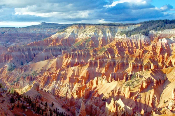
Cedar Breaks National Monument
National Monument
Crowning the Grand Staircase, Cedar Breaks sits at over 10,000 feet and looks down into a half-mile deep geologic amphitheater. Come wander among timeless bristlecone pines, stand in lush meadows of w...
13 mi from route
~32 min detour
$10
near mile 232.2
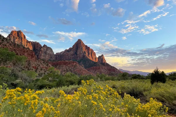
Danger: State Route 148 Closed Through Cedar Breaks National Monument
Follow the paths where people have walked for thousands of years. Gaze up at massive sandstone cliffs of cream, pink, and red that soar into a brilliant blue sky. Experience the tall, stretching walls...
14 mi from route
~35 min detour
$35
near mile 262.5
Park data from the National Park Service API. Alerts update every 2 hours.
More Details
What kind of drive is this?
You'll spend about 31% of this 292.8-mile journey on highways, with the bulk of your travel on Veterans Memorial Highway and I-70. The longest uninterrupted stretch you'll encounter is 122.6 miles, so be prepared for extended periods of driving. This route offers a mixed drive profile, suggesting a blend of faster highway speeds and potentially more varied road conditions as you progress. Expect a dynamic driving experience as you navigate through different terrains.
31% highway, the rest on surface roads — varied driving throughout.
16 navigation steps total — most of the decisions cluster near the start and finish.
Longest single stretch: 122.6 mi on Veterans Memorial Highway.
How Hard Is This Drive?
4/10
This route mixes highway mileage with some local-road sections near the start or finish. There are only a few real navigation decisions along the way. The trickiest moment comes around 0.3 miles in.
Driving Effort4/10
Easy - simple navigation with a manageable amount of wheel time
Balances navigation complexity with total wheel time.
This is a straightforward 5h 22m drive. You will face about 14 decision points, but nothing that requires special attention if you follow navigation.
Where does it get tricky?
The main spots that need attention: at 0.3 miles: Multiple destination signs - pick the right one; at 166.8 miles: Highway fork - watch signs carefully; at 290.5 miles (I 15 BUS): Exit ramp - move to the correct lane early. Lane positioning matters here.
St. George is a city in southwestern Utah, on the Utah-Arizona border, known regionally as "Utah's Dixie" (a nickname given to the area for its warm southern Utah climate which was used to grow cotton by early settlers). The city is nestled in a scenic valley of desert vistas in the northeastern Mojave Desert, adjacent to the majestic Pine Valley Mountains.
Mixed highway & surface route profile with national parks nearby.
Frequently Asked Questions
The longest stretch is about 122.6 miles on Veterans Memorial Highway. The full list of main roads is in the Roads section above.
We did not find dedicated rest areas on this route. For a drive this long, plan bathroom and stretch breaks around gas stations, fast-food stops, or small-town downtowns — check the Nearby Places section for options.
Only with planning. This is a long drive for kids — consider splitting it into two days rather than pushing through. Plan at least 1 meaningful breaks. Dedicated rest areas are limited, so plan gas or food stops as your bathroom breaks.
The main spots that need attention: at 0.3 miles: Multiple destination signs - pick the right one; at 166.8 miles: Highway fork - watch signs carefully; at 290.5 miles (I 15 BUS): Exit ramp - move to the correct lane early. Lane positioning matters here.
Yes — Cedar Breaks National Monument and Zion National Park. See the National Parks section for detour distances and tips on detours.
Not recommended in a single day. At 5.4 hours each way, a round trip means 10.7 hours of driving — that is an unsafe level of fatigue for most drivers. Plan at least one night at Saint George, UT before the return drive.