Havre to Columbia Falls is 245.8 miles and takes about 4h 47m via 1st Street and US 2, with a fuel budget near $39 and enough daylight to finish in a day. This trip stays within the Mountain West region, offering a straightforward drive across Montana. Expect a mixed driving profile rather than a pure interstate experience. With a recommended one-day travel time, it's a manageable journey for most travelers looking to cover ground efficiently.
Trip Pace
Same-day drive is realistic
A same-day return is possible, but it will make for a full day on the road.
Break Rhythm
1 planned break
Plan on a short reset every 3 to 4 hours to stay fresh behind the wheel.
Midpoint
122.9 miles from Havre, MT
A natural place for your longest stop of the day
, about 2h 22m into the drive
.
Main Roads
Road
Distance
Duration
1st Street
102 mi
1h 54m
US 2
75.3 mi
1h 24m
West Roosevelt Highway
58 mi
1h 8m
US Route 2
7.5 mi
10m
Main Street
0.8 mi
2m
East Central Avenue
0.6 mi
1m
Old US 2
0.4 mi
1m
2nd Avenue
0.3 mi
1m
Longest stretch:
1st Street
— 102 mi, about 1h 54m
Turn-by-Turn Driving Directions
Step-by-step road directions between Havre, MT and Columbia Falls, MT.
1
Start on Montana Avenue
161 ft·11 sec·Montana Avenue
2
Turn left onto 5th Street
0.1 mi·39 sec·5th Street
3
Turn left onto 2nd Avenue
0.3 mi·1 min·2nd Avenue
4
Turn left onto US 2
102 mi·1 hr 54 min·1st Street
Use the straight lane.
5
Continue on US 2
0.8 mi·2 min·Main Street
6
Turn right onto I 15 Bus; US 2
453 ft·16 sec·5th Avenue North
7
Continue on I 15 Bus; US 2
58 mi·1 hr 8 min·West Roosevelt Highway
8
Continue on US 2; US 89
0.6 mi·1 min·East Central Avenue
9
Enter roundabout onto US 2
246 ft·3 sec·US 2
10
Continue on US 2
72 mi·1 hr 19 min·US 2
11
Turn right
0.2 mi·1 min
12
At end of road, turn left onto Old US 2
0.4 mi·1 min·Old US 2
13
Turn right onto US 2
7.5 mi·10 min·US Route 2
14
Continue on US 2
3.0 mi·4 min·US 2
Use the straight lane.
15
Continue on US 2
0.3 mi·52 sec·9th Street
16
Turn right onto MT 486
0.1 mi·32 sec·Nucleus Avenue
17
Turn left onto 7th Street West
102 ft·4 sec·7th Street West
18
Arrive at destination
7th Street West
Trip Plan
Consider starting your drive from Havre in the morning to make the most of daylight for the 4h 47m trip. With only one recommended stop, you have flexibility to pause as needed, perhaps around the halfway mark. Keep an eye on your fuel levels, especially during the 102-mile stretch on 1st Street, as services might be less frequent. This is a well-paced one-day drive, so you can afford to be flexible with your timing.
Morning Departure
An early start around 7-8 AM gets you there with plenty of daylight left.
Evening Departure
A late afternoon start means arriving after dark. Morning is better.
You can normally do this drive in one day.
Plan roughly 1 meaningful break for fuel, food, and rest.
The halfway point lands around 122.9 miles from Havre, MT, or about 2h 22m into the drive.
The longest continuous stretch on this route runs about 102 miles.
This is a comfortable same-day trip.
Departure
Before you leave
Start with fuel, water, and navigation already sorted so the first hour feels easy.
First stop
Around 54 miles or 1h 2m in
Use this first pause for coffee, a restroom break, and a quick traffic check ahead.
Halfway reset
Around 122.9 miles or 2h 22m in
This is the best place for your longest stop, a real meal, and a full fuel check.
Final approach
Final hour starts around 3h 52m
Traffic, exits, and arrival timing usually matter more near Columbia Falls, MT than in the middle of the route.
Before You Leave
+
Open the route before leaving Havre, MT so your first major turns are already loaded.
+
Leave with enough water and a charging cable within reach, not packed away.
+
Check your fuel range against the first long segment, especially if you are starting outside city service areas.
Day 1
Settle into the route from Havre, MT
This is one driving day of about 245.8 miles and 4h 47m.
Your first comfortable stop window is around 54 miles from Havre, MT.
This route can stay practical as a one-day drive if traffic stays reasonable.
Plan about 1 real break rather than only quick fuel stops.
The longest stretch is on 1st Street for about 102 miles.
Where to Stop
Rest stops, refuel points, and overnight suggestions along this route.
Home stretch
0.9 mi from route
~2 min detour
$10 to $20
Columbia Falls, Montana
+14068972212
Place data sourced from public business listings. Hours and availability may vary.
Heads-up: tricky spots
5 of 10
5 decision points cluster between mile 0 and 245.8 — GPS handles the exact turns, but know they're coming. Your lane choice matters more than the turn itself.
4
0 mi into trip|~0m in|5th Street
Turn left onto 5th Street
Navigation decision point
6
0.5 mi into trip|~2m in|US 2 / 1st Street
Turn left onto US 2 / 1st Street
Lane positioning matters here
Use the straight lane.
4
162 mi into trip|~3h 9m in|US 2
Enter roundabout onto US 2
Roundabout - know your exit number before entering
5
234.5 mi into trip|~4h 30m in|Old US 2
At end of road, turn left onto Old US 2
Navigation decision point
5
245.8 mi into trip|~4h 47m in|7th Street West
Turn left onto 7th Street West
Navigation decision point
Fuel & Cost
Regular Gas
$38.31 one way
$76.62 round trip
$3.96/gal25.4 MPG avg86 kg CO2
Fuel Type
$/gal
One Way
Round Trip
midgrade
$4.17
$40.38
$80.77
premium
$4.47
$43.30
$86.59
diesel
$4.80
$46.41
$92.82
No toll roads detected on this route.
Estimated Trip Cost (one way, 1 person)
Fuel
$38
Meals
$25–$50
Total
$63–$88
Rough estimate based on US averages. Hotel $80–$140/night, meals $25–$50/day.
Estimated CO2 emission: 86 kg one way.
Prices: EIA weekly data, 2026-07-13.
Driving Electric?
About $26 in charging
· 0 stops
· 66% less CO2
Vehicle Type
kWh
Stops
DC Fast
Home Charge
Average EV
73.7
0
$25.81
$11.80
Efficient EV
61.5
0
$21.51
$9.83
EV Truck/SUV
98.3
1
$34.41
$15.73
Gas CO2
86 kg
EV CO2
29 kg (66% less)
Plan for 0 charging stops, roughly every 270 miles. Allow 25-40 minutes per stop at a DC fast charger.
DC fast charging avg $0.35/kWh. Home charging avg $0.16/kWh. US grid CO2: 0.39 kg/kWh.
Travel Intel
Current conditions at both ends of the drive.
Forecast as of Jul 18, 2026
Origin
Havre, MT
Night
in Havre on Saturday
Local time
9:57 PM
MDT
Current temp
96°F
Slight Chance Rain Showers then Chance Showers And Thunderstorms
SW 2 to 8 mph27% chanceLive forecast
Destination
Columbia Falls, MT
Night
in Columbia Falls on Saturday
Local time
9:57 PM
MDT
Current temp
89°F
Sunny
SSW 0 to 9 mph5% chanceLive forecast
Seasonal Notes
Summer travel usually means heavier construction, hotter rest stops, and busier weekend traffic around major cities.
Winter travel shortens daylight, so a route that looks manageable on paper can feel much longer after dark.
Holiday weekends tend to make both departure and arrival windows slower than the raw route time suggests.
Time zone
Same local time
Origin and destination are on the same clock, so arrival timing is easier to judge at a glance.
Temperature spread
7 degrees cooler at arrival
A meaningful temperature swing is a good cue to rethink layers, water, and how soon you want to arrive.
Road read
4h 47m on the road
An early start around 7-8 AM gets you there with plenty of daylight left.
Weather data from the National Weather Service. Conditions may change; check closer to your travel date.
National Parks Near This Route
Worth a detour if your schedule allows.
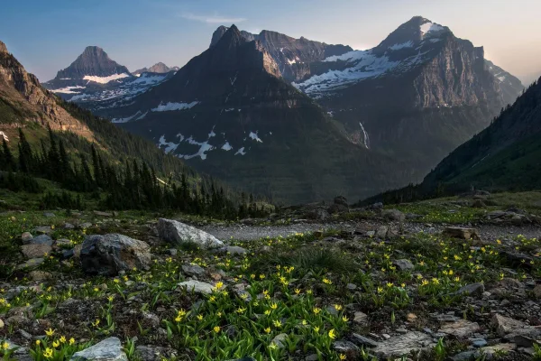
Glacier National Park
National Park
A showcase of melting glaciers, alpine meadows, carved valleys, and spectacular lakes. With over 700 miles of trails, Glacier is a paradise for adventurous visitors seeking a landscape steeped in huma...
15 mi from route
~38 min detour
$35
near mile 228.9
Park Closure: Going-to-the-Sun Road Seasonal Closure
Park data from the National Park Service API. Alerts update every 2 hours.
More Details
What kind of drive is this?
This route offers a mixed driving experience, with 34% on highways. You'll encounter stretches on 1st Street and US 2, including your longest continuous segment of 102 miles. The drive transitions between different road types, so be prepared for variations in speed and road conditions. It's not a monotonous interstate cruise, but rather a journey that requires attention as the landscape and road characteristics evolve.
34% highway, the rest on surface roads — varied driving throughout.
18 navigation steps total — most of the decisions cluster near the start and finish.
Longest single stretch: 102 mi on 1st Street.
How Hard Is This Drive?
3/10
This route mixes highway mileage with some local-road sections near the start or finish. There are only a few real navigation decisions along the way. The trickiest moment comes early in the drive near 5th Street.
Driving Effort3/10
Easy - simple navigation with a manageable amount of wheel time
Balances navigation complexity with total wheel time.
This is a straightforward 4h 47m drive. You will face about 10 decision points, but nothing that requires special attention if you follow navigation.
Where does it get tricky?
The main spots that need attention: near the start (5th Street): Navigation decision point; at 0.5 miles (US 2 / 1st Street): Lane positioning matters here; at 162 miles (US 2): Roundabout - know your exit number before entering.
Mixed highway & surface route profile with national parks nearby.
Frequently Asked Questions
The longest stretch is about 102 miles on 1st Street. The full list of main roads is in the Roads section above.
Yes — we found about 1 rest area or service plaza within a short detour of the route (from OpenStreetMap). See the Rest Stops tab under Nearby Places for locations and mile markers. Plan to stretch, use the bathroom, and top off fluids every 2–3 hours on longer drives.
Yes, with realistic expectations. Build in a stop roughly every 2 hours, have snacks and activities ready, and check the Nearby Places tabs for kid-friendly stops along the way.
Mostly yes along the main roads, but rural stretches through MT can have sparse or no coverage. Before you leave, download offline Google Maps or Apple Maps for the route, and consider downloading music or podcasts instead of streaming. If you depend on data for navigation, keep a paper backup of the turn-by-turn directions.
The main spots that need attention: near the start (5th Street): Navigation decision point; at 0.5 miles (US 2 / 1st Street): Lane positioning matters here; at 162 miles (US 2): Roundabout - know your exit number before entering.
Yes — Glacier National Park. See the National Parks section for detour distances and tips on detours.
Possible but tiring. At 4.8 hours each way, an in-and-out day trip would put you behind the wheel for 9.6 hours — manageable with a long break at Columbia Falls, MT, but most travelers stay overnight.