Origin
Gulfport, MS
Night in Gulfport on Saturday
Local time
11:34 PM
CDT
Current temp
60°F
Unavailable
Live forecast
Compiled and reviewed by the US Trip Planner planning team at COD Solutions Oy · Last reviewed Apr 19, 2026 · Editorial standards
Drive Time
4h 4m
Distance
197.7 mi
318 km
Drive Score
9/10
Great drive
Same Day?
Yes, doable
Fuel Cost
$30
one way
EV Charging
Unknown
Estimated drive times based on typical traffic patterns. Actual times may vary with weather, construction, and real-time conditions.

Gulfport, MS
Wikimedia Commons

Beechwood, MS
大 董
Gulfport, MS to Beechwood, MS is 197.7 miles and takes about 4h 4m via US 49 and I 20, with a fuel budget near $30 and enough daylight to finish in a day. This drive stays within the Southeast region, primarily in Mississippi. It's a largely highway-focused trip, making it a straightforward option for a single-day journey. With a recommended single day for completion, you won't need to worry about overnight accommodations, and the estimated fuel cost is quite manageable. Consider this route if you're looking for an efficient way to travel between these two points without extensive planning.
Trip Pace
Same-day drive is realistic
A same-day return is possible, but it will make for a full day on the road.
Break Rhythm
1 planned break
Plan on a short reset every 3 to 4 hours to stay fresh behind the wheel.
Midpoint
98.8 miles from Gulfport, MS
A natural place for your longest stop of the day , about 2h 4m into the drive .
| Road | Distance | Duration |
|---|---|---|
| US 49 | 95.3 mi | 2h |
| 25th Avenue | 60.1 mi | 1h 14m |
| I 20 | 40.5 mi | 45m |
| MS 27 | 0.8 mi | 1m |
| Paxton Road | 0.7 mi | 2m |
Step-by-step road directions between Gulfport, MS and Beechwood, MS.
Start on US 49
Continue on US 49
Turn straight onto US 49
Continue on US 49; MS 42
Continue on US 49
Continue on US 49
Continue on US 49
Continue on US 49
Take the exit onto US 49
Keep slight left at fork onto US 49
Keep slight left at fork onto US 49
Merge onto I 20; I 55; US 49
Keep slight right at fork onto I 20; US 49
Take the exit
Merge onto MS 27
Turn straight onto MS 27
Turn right
Turn left onto Paxton Road
Turn right
Arrive at destination
Given the 4h 4m estimated drive time and 197.7 miles, starting your trip in the morning is ideal for completing it within daylight hours. With only one recommended stop, you have flexibility in planning your break, perhaps around the halfway point or where you feel the need to stretch. Keep an eye on your fuel gauge, especially during the 95.3-mile stretch on US 49, as services might be more spaced out. The estimated fuel cost of $30 suggests that fuel stops should be affordable. Since this is a single-day trip, you can depart at your leisure, but an earlier start ensures a relaxed pace.
Morning Departure
An early start around 7-8 AM gets you there with plenty of daylight left.
Evening Departure
A late afternoon start means arriving after dark. Morning is better.
This is a comfortable same-day trip.
Departure
Before you leave
Start with fuel, water, and navigation already sorted so the first hour feels easy.
First stop
Around 43 miles or 53m in
Use this first pause for coffee, a restroom break, and a quick traffic check ahead.
Halfway reset
Around 98.8 miles or 2h 4m in
This is the best place for your longest stop, a real meal, and a full fuel check.
Final approach
Final hour starts around 3h 22m
Traffic, exits, and arrival timing usually matter more near Beechwood, MS than in the middle of the route.
Open the route before leaving Gulfport, MS so your first major turns are already loaded.
Leave with enough water and a charging cable within reach, not packed away.
Check your fuel range against the first long segment, especially if you are starting outside city service areas.
Day 1
Settle into the route from Gulfport, MS
This is one driving day of about 197.7 miles and 4h 4m.
Rest stops, refuel points, and overnight suggestions along this route.

Mid-route town
Meal stop
99 mi into the route
Best for: Lunch, fuel, and a longer reset
This sits close to the middle of the route, so it works well for the longest stop of the day.
A short stop after about 43 miles helps settle the day before fatigue starts building.
The midpoint is around 98.8 miles from Gulfport, MS, which is a good place for a longer meal and fuel stop.
Before the longest stretch
Fuel checkTop up before US 49 if your tank is already low. That segment runs about 95.3 miles.
These stop ideas are pacing suggestions — the exact town or exit can change with traffic, hotel plans, and fuel range.
5 decision points cluster between mile 153.7 and 196.1 — GPS handles the exact turns, but know they're coming. Your lane choice matters more than the turn itself.
Keep slight left at fork onto US 49 toward Jackson
Highway fork - watch signs carefully
Keep slight left at fork onto US 49
Highway fork - watch signs carefully
Keep slight right at fork onto I 20; US 49 toward I 20 West, US 49 North: Vicksburg, Yazoo City
Highway fork - watch signs carefully. Multiple destination signs - pick the right one
Take the exit toward MS 27: Utica
Exit ramp - move to the correct lane early
Merge onto MS 27
Merge point - match speed before joining
Regular Gas
$29.86 one way
$59.71 round trip
| Fuel Type | $/gal | One Way | Round Trip |
|---|---|---|---|
| midgrade | $4.21 | $32.78 | $65.55 |
| premium | $4.56 | $35.48 | $70.97 |
| diesel | $5.61 | $43.65 | $87.30 |
No toll roads detected on this route.
Estimated Trip Cost (one way, 1 person)
Fuel
$30
Meals
$25–$50
Total
$55–$80
Rough estimate based on US averages. Hotel $80–$140/night, meals $25–$50/day.
Estimated CO2 emission: 69.2 kg one way. Prices: EIA weekly data, 2026-04-13.
Driving Electric?
About $21 in charging · 0 stops · 67% less CO2
| Vehicle Type | kWh | Stops | DC Fast | Home Charge |
|---|---|---|---|---|
| Average EV | 59.3 | 0 | $20.76 | $9.49 |
| Efficient EV | 49.4 | 0 | $17.30 | $7.91 |
| EV Truck/SUV | 79.1 | 0 | $27.68 | $12.65 |
Gas CO2
69 kg
EV CO2
23 kg (67% less)
This trip is well within single-charge range for most EVs. No charging stops needed if you start fully charged.
DC fast charging avg $0.35/kWh. Home charging avg $0.16/kWh. US grid CO2: 0.39 kg/kWh.
Current conditions at both ends of the drive.
Origin
Night in Gulfport on Saturday
Local time
11:34 PM
CDT
Current temp
60°F
Unavailable
Destination
Night in Beechwood on Saturday
Local time
11:34 PM
CDT
Current temp
84°F
Unavailable
58°F
Sumrall, MS
99 mi in
Seasonal Notes
Summer travel usually means heavier construction, hotter rest stops, and busier weekend traffic around major cities.
Winter travel shortens daylight, so a route that looks manageable on paper can feel much longer after dark.
Holiday weekends tend to make both departure and arrival windows slower than the raw route time suggests.
Time zone
Origin and destination are on the same clock, so arrival timing is easier to judge at a glance.
Temperature spread
A meaningful temperature swing is a good cue to rethink layers, water, and how soon you want to arrive.
Road read
An early start around 7-8 AM gets you there with plenty of daylight left.
Weather data from the National Weather Service. Conditions may change; check closer to your travel date.
Worth a detour if your schedule allows.
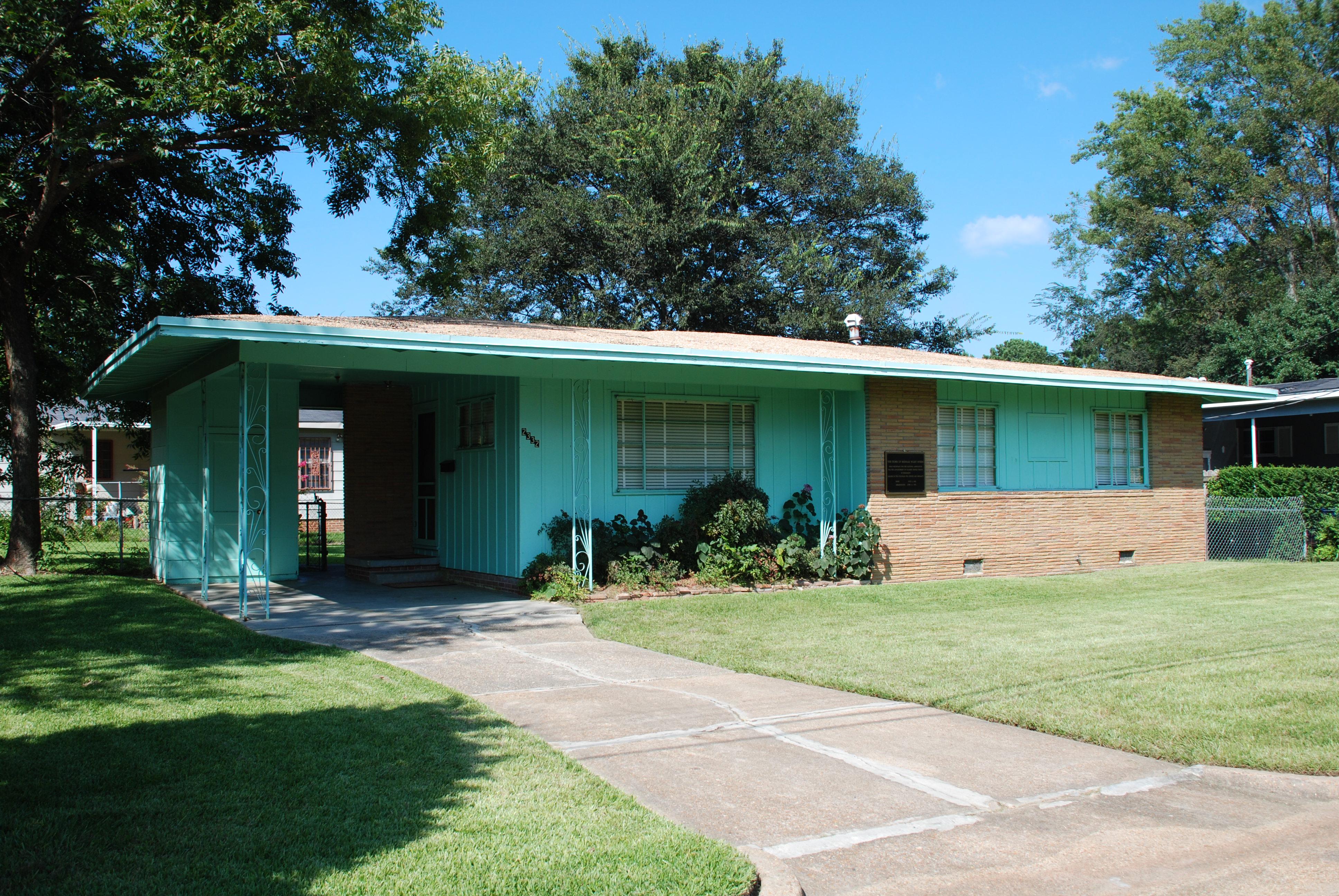
National Monument
Medgar and Myrlie Evers were partners in the civil rights struggle. The assassination of Medgar Evers in the carport of their home on June 12, 1963, was the first murder of a nationally significant le...
Park data from the National Park Service API. Alerts update every 2 hours.
This drive is predominantly highway-focused, with 69% of the route utilizing major roads like US 49 and I 20. You'll experience a long, uninterrupted stretch of 95.3 miles on US 49, which forms the backbone of the initial part of your journey. As you progress, the route transitions to interstate driving, offering a different pace and feel. Expect a mix of steady highway travel that allows for consistent speed, punctuated by sections on main roads that might offer a slightly different driving experience. The overall character is one of efficient travel designed for covering distance.
This is a straightforward highway drive that stays mostly on US 49 and 25th Avenue. This route has several spots where lane changes, forks, or exits need your full attention. The trickiest moment comes around 153.7 miles in near US 49.
Demanding - plan breaks and stay ahead of the key maneuvers
Balances navigation complexity with total wheel time.
This is a demanding drive. With 11 significant decision points across 197.7 miles, you will need to stay alert - especially through interchange areas and urban stretches. Consider splitting it into segments if you are not comfortable with fast highway navigation.
Where does it get tricky?
The main spots that need attention: at 153.7 miles (US 49): Highway fork - watch signs carefully; at 154.4 miles (US 49): Highway fork - watch signs carefully; at 157.1 miles (I 20; US 49): Highway fork - watch signs carefully. Multiple destination signs - pick the right one.
Based on OSRM destination-sign hints, not a full list of every settlement the road passes.
Between Gulfport, MS and Beechwood, MS, road signs point toward Jackson and Yazoo City.
Jackson
Yazoo City
Weekend Trip
Doable as a same-day drive at 4h 4m. Total distance: 197.7 miles.
Family Friendly
Moderate complexity with 1 natural rest stops along the way.
Solo Traveler
4h 4m drive, comfortable solo distance.
Compiled by the US Trip Planner planning team at COD Solutions Oy from open government datasets — OSRM over OpenStreetMap for geometry, EIA for fuel prices, and NPS for national parks. See our methodology for refresh cadence and limitations.
Was this helpful?
Thanks for your feedback!
Your tip has been submitted. Thanks!
/500
Recent Tips
·
Explore more options from Gulfport, MS or browse trips ending in Beechwood, MS.
Looking for more statewide routes? Browse MS road trips.