Olive Branch, MS to Beechwood, MS is 239.3 miles and takes about 4h 30m via I 55 and I 20, with a fuel budget near $36 and enough daylight to finish in a day. This trip stays within Mississippi, traversing the Southeast region. It's a highway-focused drive that makes for a straightforward, single-day journey. You'll be spending most of your time on major interstates, so expect a consistent pace. If you're looking for a simple transit between these two points, this route delivers.
Trip Pace
Same-day drive is realistic
A same-day return is possible, but it will make for a full day on the road.
Break Rhythm
1 planned break
Plan on a short reset every 3 to 4 hours to stay fresh behind the wheel.
Midpoint
119.7 miles from Olive Branch, MS
A natural place for your longest stop of the day
, about 2h 14m into the drive
.
Main Roads
Road
Distance
Duration
I 55
176.5 mi
3h 9m
I 20
28.7 mi
30m
I 269
9.2 mi
9m
Natchez Trace Parkway
6.4 mi
9m
Cockrum Road
6.2 mi
11m
I 220
5.9 mi
6m
Medgar Evers Boulevard
2 mi
2m
MS 27
0.8 mi
1m
Longest stretch:
I 55
— 176.5 mi, about 3h 9m
Traffic on I-55
Hour-of-day weekday pattern from 20 FHWA count stations on your route.
Peak
4 PM
~1,069 veh/hr typical
· worst 1,314
Quietest
2 AM
~101 veh/hr
Peak-to-quiet ratio
10.6×
busier at peak than in the quiet hours
12a6anoon6p11p
Averaged across 52 weeks of 2023 FHWA Travel Monitoring Analysis System data. Weekday hours only (Mon–Fri).
Turn-by-Turn Driving Directions
Step-by-step road directions between Olive Branch, MS and Beechwood, MS.
1
Start on Goodman Road
260 ft·12 sec·Goodman Road
2
Turn left onto MS 305
6.2 mi·11 min·Cockrum Road
3
Take the ramp
0.3 mi·41 sec
Toward Tunica
4
Merge onto I 269; MS 304
9.2 mi·9 min·I 269; MS 304
5
Take the exit
0.3 mi·44 sec
Toward I 55 South: Jackson
6
Keep slight left at fork
0.7 mi·1 min
Toward I 55 South: Jackson
7
Merge onto I 55
176 mi·3 hr 9 min·I 55
8
Take the exit
0.4 mi·45 sec
Toward I 220 South: West Jackson
9
Continue on I 220
5.9 mi·6 min·I 220
10
Take the exit
0.3 mi·40 sec
Toward US 49 North: Yazoo City
11
Keep slight right at fork
301 ft·8 sec
Toward US 49 North: Yazoo City
12
Merge onto US 49
2.0 mi·2 min·Medgar Evers Boulevard
13
Take the exit
0.3 mi·43 sec
Toward NTP
14
Turn right onto Natchez Trace Parkway
6.4 mi·9 min·Natchez Trace Parkway
15
Take the ramp
0.2 mi·30 sec
Toward 20
16
Merge onto I 20; US 80
29 mi·30 min·I 20; US 80
17
Take the exit
0.2 mi·27 sec
Toward MS 27: Utica
18
Merge onto MS 27
0.1 mi·11 sec·MS 27
19
Turn straight onto MS 27
0.7 mi·1 min·MS 27
20
Turn right
125 ft·10 sec
21
Turn left onto Paxton Road
0.7 mi·2 min·Paxton Road
22
Turn right
88 ft·6 sec
23
Arrive at destination
Trip Plan
Given the 4h 30m duration, starting your drive in Olive Branch in the morning will allow you to reach Beechwood with plenty of daylight to spare. While there's only one recommended stop, the longest stretch without a major exit is 176.5 miles on I 55, so plan your fuel and restroom breaks accordingly before embarking on this segment. With a fuel cost estimated at $36, it's a relatively economical trip. Take advantage of the single-day nature of this route by leaving when you feel most rested.
Morning Departure
An early start around 7-8 AM gets you there with plenty of daylight left.
Evening Departure
A late afternoon start means arriving after dark. Morning is better.
You can normally do this drive in one day.
Plan roughly 1 meaningful break for fuel, food, and rest.
The halfway point lands around 119.7 miles from Olive Branch, MS, or about 2h 14m into the drive.
The longest continuous stretch on this route runs about 176.5 miles.
This is a comfortable same-day trip.
Departure
Before you leave
Start with fuel, water, and navigation already sorted so the first hour feels easy.
First stop
Around 53 miles or 1h 2m in
Use this first pause for coffee, a restroom break, and a quick traffic check ahead.
Halfway reset
Around 119.7 miles or 2h 14m in
This is the best place for your longest stop, a real meal, and a full fuel check.
Final approach
Final hour starts around 3h 36m
Traffic, exits, and arrival timing usually matter more near Beechwood, MS than in the middle of the route.
Before You Leave
+
Open the route before leaving Olive Branch, MS so your first major turns are already loaded.
+
Leave with enough water and a charging cable within reach, not packed away.
+
Check your fuel range against the first long segment, especially if you are starting outside city service areas.
Day 1
Settle into the route from Olive Branch, MS
This is one driving day of about 239.3 miles and 4h 30m.
Your first comfortable stop window is around 53 miles from Olive Branch, MS.
This route can stay practical as a one-day drive if traffic stays reasonable.
Plan about 1 real break rather than only quick fuel stops.
The longest stretch is on I 55 for about 176.5 miles.
Where to Stop
Rest stops, refuel points, and overnight suggestions along this route.
Place data sourced from public business listings. Hours and availability may vary.
Heads-up: tricky spots
5 of 19
5 decision points cluster between mile 0 and 208.6 — GPS handles the exact turns, but know they're coming. Your lane choice matters more than the turn itself.
4
0 mi into trip|~0m in|MS 305 / Cockrum Road
Turn left onto MS 305 / Cockrum Road
Navigation decision point
4
6.3 mi into trip|~11m in
Take the ramp toward Tunica
Navigation decision point
Toward Tunica
5
16.1 mi into trip|~22m in
Keep slight left at fork toward I 55 South: Jackson
Highway fork - watch signs carefully
Toward I 55 South: Jackson
5
199.9 mi into trip|~3h 41m in
Keep slight right at fork toward US 49 North: Yazoo City
Highway fork - watch signs carefully
Toward US 49 North: Yazoo City
5
208.6 mi into trip|~3h 54m in
Take the ramp toward 20
Navigation decision point
Toward 20
Fuel & Cost
Regular Gas
$33.22 one way
$66.44 round trip
$3.53/gal25.4 MPG avg84 kg CO2
Fuel Type
$/gal
One Way
Round Trip
midgrade
$3.95
$37.17
$74.33
premium
$4.29
$40.41
$80.82
diesel
$4.80
$45.18
$90.37
No toll roads detected on this route.
Estimated Trip Cost (one way, 1 person)
Fuel
$33
Meals
$25–$50
Total
$58–$83
Rough estimate based on US averages. Hotel $80–$140/night, meals $25–$50/day.
Estimated CO2 emission: 83.7 kg one way.
Prices: EIA weekly data, 2026-07-13.
Driving Electric?
About $25 in charging
· 0 stops
· 67% less CO2
Vehicle Type
kWh
Stops
DC Fast
Home Charge
Average EV
71.8
0
$25.13
$11.49
Efficient EV
59.8
0
$20.94
$9.57
EV Truck/SUV
95.7
1
$33.50
$15.32
Gas CO2
84 kg
EV CO2
28 kg (67% less)
Plan for 0 charging stops, roughly every 270 miles. Allow 25-40 minutes per stop at a DC fast charger.
DC fast charging avg $0.35/kWh. Home charging avg $0.16/kWh. US grid CO2: 0.39 kg/kWh.
Travel Intel
Current conditions at both ends of the drive.
Forecast as of Jul 18, 2026
Origin
Olive Branch, MS
Late night
in Olive Branch on Sunday
Local time
4:38 AM
CDT
Current temp
94°F
Sunny
W 5 to 10 mph6% chanceLive forecast
Heat Advisory
Heat Advisory issued July 18 at 4:25AM CDT until July 18 at 8:00PM CDT by NWS Memphis TN
Heat Advisory
Heat Advisory issued July 18 at 1:20AM CDT until July 18 at 6:00PM CDT by NWS New Orleans LA
Destination
Beechwood, MS
Late night
in Beechwood on Sunday
Local time
4:38 AM
CDT
Current temp
96°F
Sunny
WNW 0 to 5 mph2% chanceLive forecast
Heat Advisory
Heat Advisory issued July 18 at 4:25AM CDT until July 18 at 8:00PM CDT by NWS Memphis TN
Heat Advisory
Heat Advisory issued July 18 at 1:20AM CDT until July 18 at 6:00PM CDT by NWS New Orleans LA
Seasonal Notes
Summer travel usually means heavier construction, hotter rest stops, and busier weekend traffic around major cities.
Winter travel shortens daylight, so a route that looks manageable on paper can feel much longer after dark.
Holiday weekends tend to make both departure and arrival windows slower than the raw route time suggests.
Time zone
Same local time
Origin and destination are on the same clock, so arrival timing is easier to judge at a glance.
Temperature spread
2 degrees warmer at arrival
A meaningful temperature swing is a good cue to rethink layers, water, and how soon you want to arrive.
Road read
4h 30m on the road
An early start around 7-8 AM gets you there with plenty of daylight left.
Weather data from the National Weather Service. Conditions may change; check closer to your travel date.
National Parks Near This Route
Worth a detour if your schedule allows.
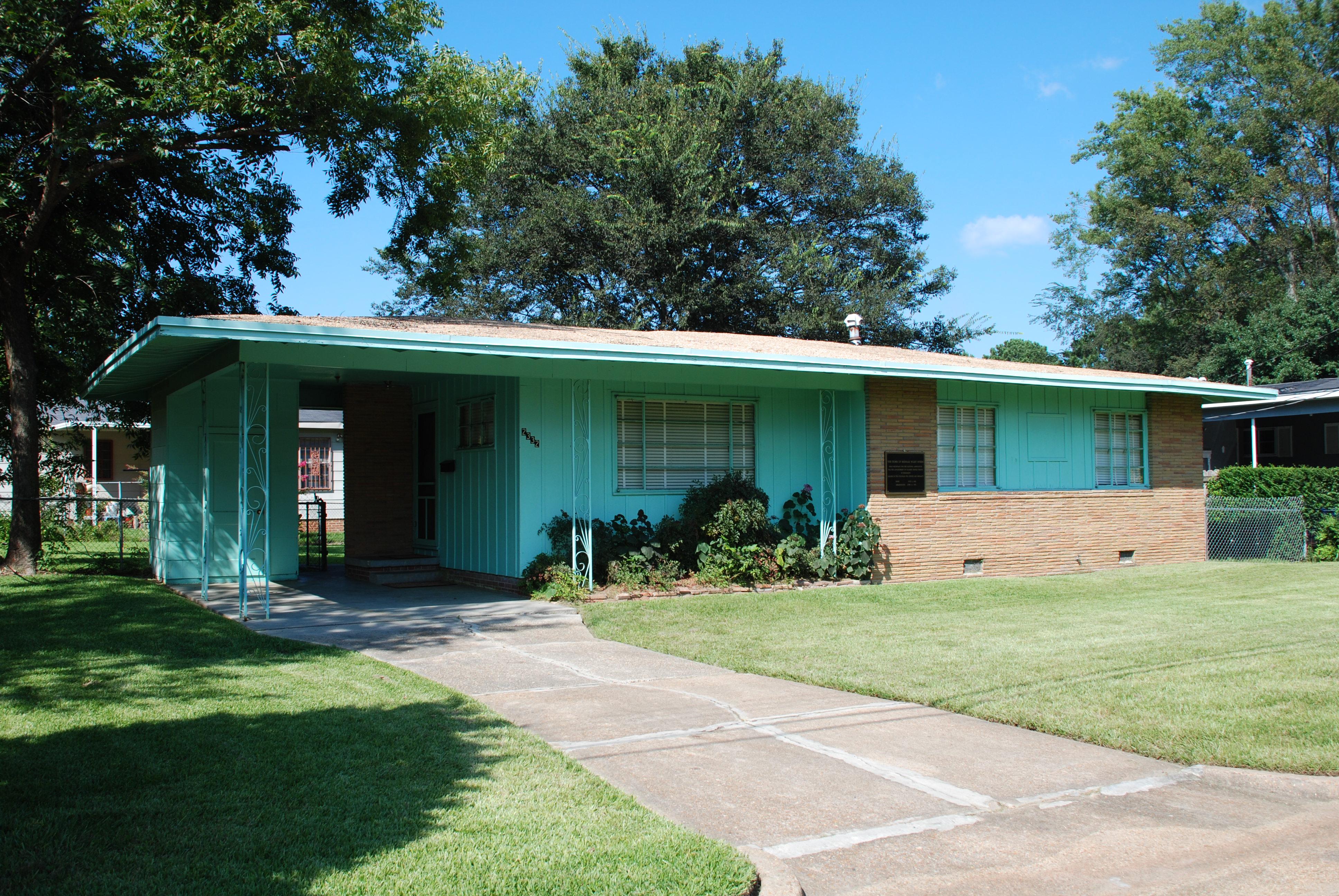
Medgar and Myrlie Evers Home National Monument
National Monument
Medgar and Myrlie Evers were partners in the civil rights struggle. The assassination of Medgar Evers in the carport of their home on June 12, 1963, was the first murder of a nationally significant le...
3 mi from route
~6 min detour
Free
near mile 198.1
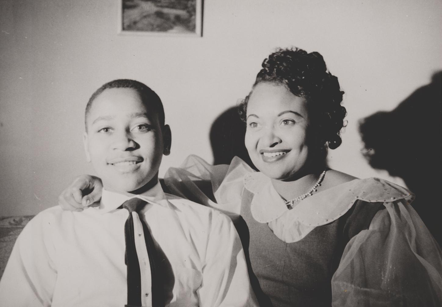
Emmett Till and Mamie Till-Mobley National Monument
National Monument
In 1955, 14-year-old Emmett Till traveled to Money, Mississippi, to visit relatives. He was kidnapped, tortured, and murdered after reportedly whistling at a white woman. His mother, Mamie Till-Mobley...
28 mi from route
~71 min detour
Free
near mile 74.3
Park data from the National Park Service API. Alerts update every 2 hours.
More Details
What kind of drive is this?
This is primarily a highway-focused drive, with 95% of the journey on interstates. You'll spend a significant portion on I 55, including an uninterrupted stretch of 176.5 miles, so be prepared for a substantial period of consistent driving. The route utilizes I 55, I 20, and I 269, indicating a network of high-speed roads. Expect a steady, functional drive with minimal deviations from the interstate system.
95% highway — fuel and pacing are the main things to plan.
23 navigation steps total — most of the decisions cluster near the start and finish.
Longest single stretch: 176.5 mi on I 55.
How Hard Is This Drive?
7/10
This is a straightforward highway drive that stays mostly on I 55 and I 20. This route has several spots where lane changes, forks, or exits need your full attention. The trickiest moment comes early in the drive near MS 305 / Cockrum Road.
Driving Effort7/10
Demanding - plan breaks and stay ahead of the key maneuvers
Balances navigation complexity with total wheel time.
This is a demanding drive. With 19 significant decision points across 239.3 miles, you will need to stay alert - especially through interchange areas and urban stretches. Consider splitting it into segments if you are not comfortable with fast highway navigation.
Where does it get tricky?
The main spots that need attention: near the start (MS 305 / Cockrum Road): Navigation decision point; at 6.3 miles: Navigation decision point; at 16.1 miles: Highway fork - watch signs carefully.
Elevation Profile
Mostly flat terrain
384 ft203 ft
Total Climb
244 ft
Total Descent
419 ft
Highest Point
384 ft
Elevation Range
181 ft
Towns Mentioned on Route Signs
Based on OSRM destination-sign hints, not a full list of every settlement the road passes.
On the drive from Olive Branch, MS to Beechwood, MS, road signs begin pointing toward Ntp along the way.
Doable as a same-day drive at 4h 30m. Total distance: 239.3 miles.
Family Friendly
Moderate complexity with 1 natural rest stops along the way.
Solo Traveler
4h 30m drive, comfortable solo distance.
First-Time Driver
Mostly highway driving (95%). Some complex stretches to watch for.
Frequently Asked Questions
The longest stretch is about 176.5 miles on I 55. The full list of main roads is in the Roads section above.
Yes — we found about 11 rest areas or service plazas within a short detour of the route (from OpenStreetMap). See the Rest Stops tab under Nearby Places for locations and mile markers. Plan to stretch, use the bathroom, and top off fluids every 2–3 hours on longer drives.
It helps. This route has a higher-than-average number of complex decision points, which get harder in the dark. If the last hour of the trip is on surface roads or mountain grades, aim to arrive at Beechwood, MS before sunset when you can. Check the Trip Plan for departure windows that land you in daylight.
Only with planning. This is a long drive for kids — consider splitting it into two days rather than pushing through. Plan at least 1 meaningful breaks. There are 11 rest areas along the route for bathroom stops.
The main spots that need attention: near the start (MS 305 / Cockrum Road): Navigation decision point; at 6.3 miles: Navigation decision point; at 16.1 miles: Highway fork - watch signs carefully.
Yes — Medgar and Myrlie Evers Home National Monument and Emmett Till and Mamie Till-Mobley National Monument. See the National Parks section for detour distances and tips on detours.
Possible but tiring. At 4.5 hours each way, an in-and-out day trip would put you behind the wheel for 9.0 hours — manageable with a long break at Beechwood, MS, but most travelers stay overnight.