Green River, WY to Sundance, WY is 428.1 miles and takes about 7h 43m via Dwight D. Eisenhower Highway and I 90, with a fuel budget near $76 and enough daylight to finish in a day. This trip stays within the Mountain West region, offering a consistent feel throughout. You'll be spending a good portion of your time on major highways, making for relatively straightforward travel. With only two planned stops and a single day recommended, this route is ideal for those looking to cover ground efficiently. Consider this a solid option if you need to get from point A to point B across Wyoming with minimal fuss.
Trip Pace
Same-day drive is realistic
A same-day return is possible, but it will make for a full day on the road.
Break Rhythm
2 planned breaks
Plan on a short reset every 3 to 4 hours to stay fresh behind the wheel.
Midpoint
214 miles from Green River, WY
A natural place for your longest stop of the day
, about 3h 47m into the drive
.
Main Roads
Road
Distance
Duration
Dwight D. Eisenhower Highway
119.3 mi
1h 55m
WY 220
63.7 mi
1h 12m
I 90
56.5 mi
56m
WY 387
51.3 mi
58m
3rd Street
44.1 mi
50m
State Highway 59 South
32.8 mi
35m
I 25
20.1 mi
18m
Horseshoe Road
17.9 mi
20m
Longest stretch:
Dwight D. Eisenhower Highway
— 119.3 mi, about 1h 55m
Traffic on I-80
Hour-of-day weekday pattern from 12 FHWA count stations on your route.
Peak
4 PM
~664 veh/hr typical
· worst 902
Quietest
2 AM
~94 veh/hr
Peak-to-quiet ratio
7.1×
busier at peak than in the quiet hours
12a6anoon6p11p
Averaged across 52 weeks of 2023 FHWA Travel Monitoring Analysis System data. Weekday hours only (Mon–Fri).
Turn-by-Turn Driving Directions
Step-by-step road directions between Green River, WY and Sundance, WY.
1
Start on North 1st East
35 ft·6 sec·North 1st East
2
Turn left onto I 80 Bus; US 30 Bus
1.1 mi·2 min·East Flaming Gorge Way
3
Take the ramp onto I 80 Bus; US 30 Bus
0.7 mi·1 min·I 80 Bus; US 30 Bus
Toward I 80 East, US 30 East: Rock Springs
4
Merge onto I 80; US 30
119 mi·1 hr 55 min·Dwight D. Eisenhower Highway
5
Take the exit onto WY 789
0.4 mi·52 sec·WY 789
Toward I 80 Business East, WY 789 North: Rawlins
6
Turn left onto I 80 Bus; US 30 Bus; WY 789
1.7 mi·2 min·West Spruce Street
7
Turn left onto US 287; WY 789
44 mi·50 min·3rd Street
8
Continue on WY 220
64 mi·1 hr 12 min·WY 220
9
Turn left onto WY 257
7.3 mi·8 min·Casper West Belt
10
Continue on US 20; US 26
3.0 mi·3 min·US 20; US 26
11
Turn left
0.4 mi·50 sec
Toward I 25 North, US 87 North: Midwest
12
Merge onto I 25; US 87
20 mi·18 min·I 25; US 87
13
Take the exit
0.4 mi·50 sec
Toward Horse Ranch Creek Road
14
Turn right onto WY 259
18 mi·20 min·Horseshoe Road
15
Turn right onto WY 387
51 mi·58 min·WY 387
16
Turn left onto WY 59
33 mi·35 min·State Highway 59 South
17
Continue on WY 59
1.7 mi·2 min·South Douglas Highway
18
Take the exit
436 ft·13 sec
19
Turn straight onto South Garner Lake Road
4.0 mi·6 min·South Garner Lake Road
20
Take the ramp onto I 90; US 14; US 16
57 mi·56 min·I 90; US 14; US 16
21
Take the exit onto I 90 Business
0.3 mi·33 sec·I 90 Business
22
Turn right onto I 90 Business; US 14
0.7 mi·1 min·US Highway 14
23
Continue on I 90 Business; US 14
0.5 mi·44 sec·South West Street
24
Continue on I 90 Business; US 14
0.3 mi·30 sec·East Cleveland Street
25
Arrive at destination
I 90 Business; US 14
Trip Plan
Given the 7h 43m estimated drive time, leaving Green River in the morning is your best bet to arrive in Sundance with daylight to spare. The route has two recommended stops, so plan to stretch your legs and refuel accordingly. Keep an eye on your fuel gauge, especially during the 119.3-mile stretch on the Dwight D. Eisenhower Highway, as services can be spread out. The estimated fuel cost of $76 is a helpful budget point, but always factor in a buffer. Since this is a single-day drive, you have flexibility, but being prepared for Wyoming's variable weather is always wise.
Morning Departure
Start early — leave by 6-7 AM to arrive at a reasonable hour.
Evening Departure
This is a long drive — plan for a morning departure or consider splitting it into two days.
You can normally do this drive in one day.
Plan roughly 2 meaningful breaks for fuel, food, and rest.
The halfway point lands around 214 miles from Green River, WY, or about 3h 47m into the drive.
The longest continuous stretch on this route runs about 119.3 miles.
This is a comfortable same-day trip.
Departure
Before you leave
Start with fuel, water, and navigation already sorted so the first hour feels easy.
First stop
Around 94 miles or 1h 33m in
Use this first pause for coffee, a restroom break, and a quick traffic check ahead.
Halfway reset
Around 214 miles or 3h 47m in
This is the best place for your longest stop, a real meal, and a full fuel check.
Final approach
Final hour starts around 6h 41m
Traffic, exits, and arrival timing usually matter more near Sundance, WY than in the middle of the route.
Before You Leave
+
Open the route before leaving Green River, WY so your first major turns are already loaded.
+
Leave with enough water and a charging cable within reach, not packed away.
+
Check your fuel range against the first long segment, especially if you are starting outside city service areas.
+
Pick one backup stop option before the midpoint in case traffic changes your pacing.
Day 1
Settle into the route from Green River, WY
This is one driving day of about 428.1 miles and 7h 43m.
Your first comfortable stop window is around 94 miles from Green River, WY.
This route can stay practical as a one-day drive if traffic stays reasonable.
Plan about 2 real breaks rather than only quick fuel stops.
The longest stretch is on Dwight D. Eisenhower Highway for about 119.3 miles.
Where to Stop
Rest stops, refuel points, and overnight suggestions along this route.
Place data sourced from public business listings. Hours and availability may vary.
Heads-up: tricky spots
5 of 17
5 decision points cluster between mile 0 and 261.6 — GPS handles the exact turns, but know they're coming. Your lane choice matters more than the turn itself.
4
0 mi into trip|~0m in|I 80 Bus; US 30 Bus / East Flaming Gorge Way
Turn left onto I 80 Bus; US 30 Bus / East Flaming Gorge Way
Navigation decision point
4
1.1 mi into trip|~2m in|I 80 Bus; US 30 Bus
Take the ramp onto I 80 Bus; US 30 Bus toward I 80 East, US 30 East: Rock Springs
Multiple destination signs - pick the right one
Toward I 80 East, US 30 East: Rock Springs
5
121 mi into trip|~2h in|WY 789
Take the exit onto WY 789 toward I 80 Business East, WY 789 North: Rawlins
Exit ramp - move to the correct lane early. Multiple destination signs - pick the right one
Toward I 80 Business East, WY 789 North: Rawlin...
5
241.1 mi into trip|~4h 19m in
Turn left toward I 25 North, US 87 North: Midwest
Multiple destination signs - pick the right one
Toward I 25 North, US 87 North: Midwest
4
261.6 mi into trip|~4h 39m in
Take the exit toward Horse Ranch Creek Road
Exit ramp - move to the correct lane early
Toward Horse Ranch Creek Road
Fuel & Cost
Regular Gas
$66.73 one way
$133.45 round trip
$3.96/gal25.4 MPG avg150 kg CO2
Fuel Type
$/gal
One Way
Round Trip
midgrade
$4.17
$70.33
$140.67
premium
$4.47
$75.41
$150.81
diesel
$4.80
$80.83
$161.67
No toll roads detected on this route.
Estimated Trip Cost (one way, 1 person)
Fuel
$67
Meals
$25–$50
Total
$92–$117
Rough estimate based on US averages. Hotel $80–$140/night, meals $25–$50/day.
Estimated CO2 emission: 149.8 kg one way.
Prices: EIA weekly data, 2026-07-13.
Driving Electric?
About $45 in charging
· 1 stop
· 67% less CO2
Vehicle Type
kWh
Stops
DC Fast
Home Charge
Average EV
128.4
1
$44.95
$20.55
Efficient EV
107
1
$37.46
$17.12
EV Truck/SUV
171.2
2
$59.93
$27.40
Gas CO2
150 kg
EV CO2
50 kg (67% less)
Plan for 1 charging stop. A 30-minute DC fast charge mid-route should be enough to complete the trip comfortably.
DC fast charging avg $0.35/kWh. Home charging avg $0.16/kWh. US grid CO2: 0.39 kg/kWh.
Travel Intel
Current conditions at both ends of the drive.
Forecast as of Jul 17, 2026
Origin
Green River, WY
Evening
in Green River on Saturday
Local time
7:32 PM
MDT
Current temp
58°F
Chance Showers And Thunderstorms then Mostly Cloudy
NNE 2 to 9 mph33% chanceLive forecast
Heat Advisory
Heat Advisory issued July 16 at 7:09PM MDT until July 19 at 9:00PM MDT by NWS Rapid City SD
Flash Flood Warning
Flash Flood Warning issued July 16 at 6:32PM MDT until July 16 at 7:30PM MDT by NWS Riverton WY
Destination
Sundance, WY
Evening
in Sundance on Saturday
Local time
7:32 PM
MDT
Current temp
63°F
Partly Cloudy
NE 5 mph13% chanceLive forecast
Heat Advisory
Heat Advisory issued July 16 at 7:09PM MDT until July 19 at 9:00PM MDT by NWS Rapid City SD
Flash Flood Warning
Flash Flood Warning issued July 16 at 6:32PM MDT until July 16 at 7:30PM MDT by NWS Riverton WY
Seasonal Notes
Summer travel usually means heavier construction, hotter rest stops, and busier weekend traffic around major cities.
Winter travel shortens daylight, so a route that looks manageable on paper can feel much longer after dark.
Holiday weekends tend to make both departure and arrival windows slower than the raw route time suggests.
Time zone
Same local time
Origin and destination are on the same clock, so arrival timing is easier to judge at a glance.
Temperature spread
5 degrees warmer at arrival
A meaningful temperature swing is a good cue to rethink layers, water, and how soon you want to arrive.
Road read
7h 43m on the road
Start early — leave by 6-7 AM to arrive at a reasonable hour.
Weather data from the National Weather Service. Conditions may change; check closer to your travel date.
National Parks Near This Route
Worth a detour if your schedule allows.
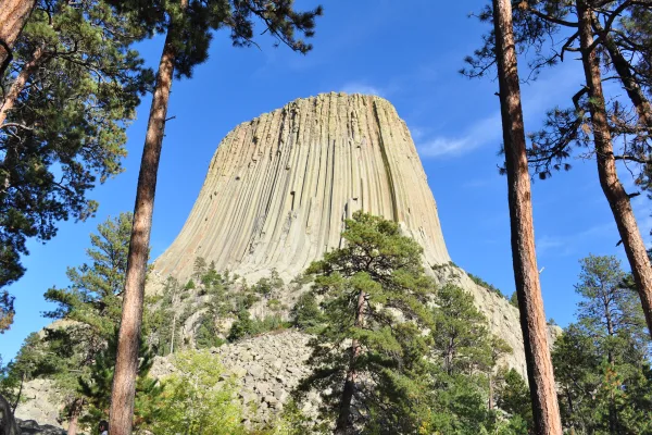
Devils Tower National Monument
National Monument
The Tower is an astounding geologic feature that protrudes out of the prairie surrounding the Black Hills. It is considered sacred by Northern Plains Indians and indigenous people. Hundreds of paralle...
20 mi from route
~49 min detour
$25
near mile 413.3
Park Closure: Temporary closure of some rock climbing routes to protect falcon nesting sites.
Park Closure: The campground is closed for the season.
Park data from the National Park Service API. Alerts update every 2 hours.
More Details
What kind of drive is this?
You'll spend 54% of your 428.1 miles on the highway, which means a significant portion will be high-speed cruising. The longest continuous stretch on the Dwight D. Eisenhower Highway is 119.3 miles. After the highway segments, you'll transition to surface roads for the remainder of the trip. Expect to notice a change in the surrounding landscape and potentially a decrease in exit frequency as you move from interstate to state routes.
54% highway, the rest on surface roads — varied driving throughout.
25 navigation steps total — most of the decisions cluster near the start and finish.
Longest single stretch: 119.3 mi on Dwight D. Eisenhower Highway.
How Hard Is This Drive?
4/10
This route mixes highway mileage with some local-road sections near the start or finish. There are only a few real navigation decisions along the way. The trickiest moment comes early in the drive near I 80 Bus; US 30 Bus / East Flaming Gorge Way.
Driving Effort4/10
Easy - simple navigation with a manageable amount of wheel time
Balances navigation complexity with total wheel time.
The route itself is not hard, but at 7h 43m, endurance matters. Plan breaks every 2-3 hours. The 17 decision points are all manageable with basic attention.
Where does it get tricky?
The main spots that need attention: near the start (I 80 Bus; US 30 Bus / East Flaming Gorge Way): Navigation decision point; at 1.1 miles (I 80 Bus; US 30 Bus): Multiple destination signs - pick the right one; at 121 miles (WY 789): Exit ramp - move to the correct lane early. Multiple destination signs - pick the right one.
Elevation Profile
High-altitude sections with notable climbs
6,947 ft4,323 ft
Total Climb
1,521 ft
Total Descent
2,884 ft
Highest Point
6,947 ft
~91.7 mi in
Elevation Range
2,624 ft
Notable High Points
6,947 ft at ~91.7 miles+128 ft prominence
5,395 ft at ~305.8 miles+260 ft prominence
Detours Along the Way
Tagged by where each one fits in your drive — first break, midpoint, final stretch.
Mixed highway & surface route profile with national parks nearby.
Frequently Asked Questions
The longest stretch is about 119.3 miles on Dwight D. Eisenhower Highway. The full list of main roads is in the Roads section above.
Yes — we found about 9 rest areas or service plazas within a short detour of the route (from OpenStreetMap). See the Rest Stops tab under Nearby Places for locations and mile markers. Plan to stretch, use the bathroom, and top off fluids every 2–3 hours on longer drives.
It helps. This is a long drive, so arriving tired and in the dark compounds. If the last hour of the trip is on surface roads or mountain grades, aim to arrive at Sundance, WY before sunset when you can. Check the Trip Plan for departure windows that land you in daylight.
Only with planning. This is a long drive for kids — consider splitting it into two days rather than pushing through. Plan at least 2 meaningful breaks. There are 9 rest areas along the route for bathroom stops.
Mostly yes along the main roads, but rural stretches through WY can have sparse or no coverage. Before you leave, download offline Google Maps or Apple Maps for the route, and consider downloading music or podcasts instead of streaming. If you depend on data for navigation, keep a paper backup of the turn-by-turn directions.
The main spots that need attention: near the start (I 80 Bus; US 30 Bus / East Flaming Gorge Way): Navigation decision point; at 1.1 miles (I 80 Bus; US 30 Bus): Multiple destination signs - pick the right one; at 121 miles (WY 789): Exit ramp - move to the correct lane early. Multiple destination signs - pick the right one.
Yes — Devils Tower National Monument. See the National Parks section for detour distances and tips on detours.
Not recommended in a single day. At 7.7 hours each way, a round trip means 15.4 hours of driving — that is an unsafe level of fatigue for most drivers. Plan at least one night at Sundance, WY before the return drive.