This 250.2-mile journey from Gilbert, AZ to the Grand Canyon, AZ is achievable in about 4 hours and 41 minutes, making it a feasible day trip. The drive will cost an estimated $50 in fuel. You'll primarily navigate the Arizona Veterans Highway, Williams–Grand Canyon–Cameron Highway, and Black Canyon Freeway. While much of the route involves local roads, it's a straightforward path through the Desert Southwest. Given the manageable distance and duration, you can comfortably complete this drive in a single day, allowing for flexibility in your schedule.
Trip Pace
Same-day drive is realistic
A same-day return is possible, but it will make for a full day on the road.
Break Rhythm
1 planned break
Plan on a short reset every 3 to 4 hours to stay fresh behind the wheel.
Midpoint
125.1 miles from Gilbert, AZ
A natural place for your longest stop of the day
, about 2h 17m into the drive
.
To maximize your time at the Grand Canyon, consider an early morning departure from Gilbert, AZ. This 250.2-mile trip is well-suited for a single-day excursion, so you have the flexibility to stop as needed. With a total duration of 4 hours and 41 minutes, you can easily incorporate a brief rest stop or two. Keep an eye on your fuel gauge, especially during the longer 90.9-mile stretch on Arizona Veterans Highway, as services may be more spread out in this region.
Morning Departure
An early start around 7-8 AM gets you there with plenty of daylight left.
Evening Departure
A late afternoon start means arriving after dark. Morning is better.
You can normally do this drive in one day.
Plan roughly 1 meaningful break for fuel, food, and rest.
The halfway point lands around 125.1 miles from Gilbert, AZ, or about 2h 17m into the drive.
The longest continuous stretch on this route runs about 90.9 miles.
This is a comfortable same-day trip.
Departure
Before you leave
Start with fuel, water, and navigation already sorted so the first hour feels easy.
First stop
Around 55 miles or 1h 5m in
Use this first pause for coffee, a restroom break, and a quick traffic check ahead.
Halfway reset
Around 125.1 miles or 2h 17m in
This is the best place for your longest stop, a real meal, and a full fuel check.
Final approach
Final hour starts around 3h 41m
Traffic, exits, and arrival timing usually matter more near Grand Canyon, AZ than in the middle of the route.
Before You Leave
+
Open the route before leaving Gilbert, AZ so your first major turns are already loaded.
+
Leave with enough water and a charging cable within reach, not packed away.
+
Check your fuel range against the first long segment, especially if you are starting outside city service areas.
Day 1
Settle into the route from Gilbert, AZ
This is one driving day of about 250.2 miles and 4h 41m.
Your first comfortable stop window is around 55 miles from Gilbert, AZ.
This route can stay practical as a one-day drive if traffic stays reasonable.
Plan about 1 real break rather than only quick fuel stops.
The longest stretch is on Arizona Veterans Highway for about 90.9 miles.
Where to Stop
Rest stops, refuel points, and overnight suggestions along this route.
Place data sourced from public business listings. Hours and availability may vary.
Heads-up: tricky spots
5 of 18
5 decision points cluster between mile 0.3 and 18 — GPS handles the exact turns, but know they're coming. Your lane choice matters more than the turn itself.
6
0.3 mi into trip|~1m in|East Vaughn Avenue
At end of road, turn left onto East Vaughn Avenue
Complex interchange - multiple decisions in a short stretch
7
2.5 mi into trip|~5m in
Turn left toward US 60 West: Phoenix
Lane positioning matters here
Use the left lane.
Toward US 60 West: Phoenix
5
2.8 mi into trip|~6m in|US 60 / Superstition Freeway
Merge onto US 60 / Superstition Freeway
Merge point - match speed before joining. Lane positioning matters here
Use the straight / slight right lanes.
5
12.6 mi into trip|~18m in|US 60
Keep slight left at fork onto US 60 toward I 10 North
Highway fork - watch signs carefully
Toward I 10 North
8
18 mi into trip|~24m in|US 60 / Maricopa Freeway
Keep slight right at fork onto US 60 / Maricopa Freeway toward I-17 North, US-60 West: Flagstaff
Highway fork - watch signs carefully. Lane positioning matters here. Multiple destination signs - pick the right one
Use the slight right lane.
Toward I-17 North, US-60 West: Flagstaff
Fuel & Cost
Regular Gas
$44.34 one way
$88.67 round trip
$4.50/gal25.4 MPG avg88 kg CO2
Fuel Type
$/gal
One Way
Round Trip
midgrade
$4.82
$47.48
$94.96
premium
$5.04
$49.67
$99.33
diesel
$4.80
$47.24
$94.48
No toll roads detected on this route.
Estimated Trip Cost (one way, 1 person)
Fuel
$44
Meals
$25–$50
Total
$69–$94
Rough estimate based on US averages. Hotel $80–$140/night, meals $25–$50/day.
Estimated CO2 emission: 87.5 kg one way.
Prices: EIA weekly data, 2026-07-13.
Driving Electric?
About $26 in charging
· 0 stops
· 67% less CO2
Vehicle Type
kWh
Stops
DC Fast
Home Charge
Average EV
75.1
0
$26.27
$12.01
Efficient EV
62.6
0
$21.89
$10.01
EV Truck/SUV
100.1
1
$35.03
$16.01
Gas CO2
88 kg
EV CO2
29 kg (67% less)
Plan for 0 charging stops, roughly every 270 miles. Allow 25-40 minutes per stop at a DC fast charger.
DC fast charging avg $0.35/kWh. Home charging avg $0.16/kWh. US grid CO2: 0.39 kg/kWh.
Travel Intel
Current conditions at both ends of the drive.
Forecast as of Jul 18, 2026
Origin
Gilbert, AZ
Late night
in Gilbert on Sunday
Local time
2:38 AM
MST
Current temp
78°F
Chance Showers And Thunderstorms
NE 0 to 5 mph32% chanceLive forecast
Destination
Grand Canyon, AZ
Late night
in Grand Canyon on Sunday
Local time
2:38 AM
MST
Current temp
62°F
Partly Cloudy
W 6 mph10% chanceLive forecast
Seasonal Notes
Summer travel usually means heavier construction, hotter rest stops, and busier weekend traffic around major cities.
Winter travel shortens daylight, so a route that looks manageable on paper can feel much longer after dark.
Holiday weekends tend to make both departure and arrival windows slower than the raw route time suggests.
Time zone
Same local time
Origin and destination are on the same clock, so arrival timing is easier to judge at a glance.
Temperature spread
16 degrees cooler at arrival
A meaningful temperature swing is a good cue to rethink layers, water, and how soon you want to arrive.
Road read
4h 41m on the road
An early start around 7-8 AM gets you there with plenty of daylight left.
Weather data from the National Weather Service. Conditions may change; check closer to your travel date.
National Parks Near This Route
Worth a detour if your schedule allows.
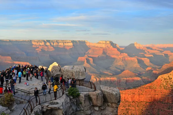
Grand Canyon National Park
National Park
Entirely within the state of Arizona, the park encompasses 278 miles (447 km) of the Colorado River and adjacent uplands. Located on the ancestral homelands of 11 present day Tribal Communities, Grand...
4 mi from route
~10 min detour
$35
near mile 250.2
Park Closure: Water Conservation Measures in Effect for South Rim
Park Closure: Critical Backcountry Updates/Closures
Established December 8, 1906, Montezuma Castle is the third National Monument dedicated to preserving Native American culture. This 20 room high-rise apartment, nestled into a towering limestone cliff...
4 mi from route
~10 min detour
$10
near mile 112.2
Since time immemorial, Indigenous Peoples have lived and traveled throughout Walnut Canyon’s dynamic landscape. Vibrant communities built their homes in the cliffs and farmed along the canyon’s rim. T...
9 mi from route
~23 min detour
$25
near mile 163.9
Water flows under and through this landscape, feeding the growth of people and towns. The Verde Valley is watered by snowmelt, summer monsoons, and springs that well up from the ancient sedimentary ro...
15 mi from route
~38 min detour
$10
near mile 112.2
The lava flow lies on the land like a dream, a wonderland of rock. A thousand years ago the ground was torn open and lava erupted into the sky, forever changing the landscape and the lives of the peop...
16 mi from route
~40 min detour
$25
near mile 163.9
An Ancestral Sonoran Desert People's farming community and "Great House" are preserved at Casa Grande Ruins. Whether a gathering place for people or simply a waypoint marker in an extensive system of...
Park data from the National Park Service API. Alerts update every 2 hours.
More Details
What kind of drive is this?
Expect a turn-heavy local drive with a 24% highway share. The longest uninterrupted stretch you'll encounter is 90.9 miles along the Arizona Veterans Highway. This route offers a mix of driving experiences, transitioning from potentially faster highway segments to more winding local roads as you approach your destination. The character of the drive changes, requiring your attention as you navigate these varied road types.
Only 24% highway — the rest is turn-by-turn surface driving.
30 navigation steps total — most of the decisions cluster near the start and finish.
Longest single stretch: 90.9 mi on Arizona Veterans Highway.
How Hard Is This Drive?
8/10
Expect a hands-on drive with frequent turns and local roads rather than long highway stretches. This route has several spots where lane changes, forks, or exits need your full attention. The trickiest moment comes around 0.3 miles in near East Vaughn Avenue.
Driving Effort8/10
Demanding - plan breaks and stay ahead of the key maneuvers
Balances navigation complexity with total wheel time.
This is a demanding drive. With 18 significant decision points across 250.2 miles, you will need to stay alert - especially through interchange areas and urban stretches. Consider splitting it into segments if you are not comfortable with fast highway navigation.
Where does it get tricky?
The main spots that need attention: at 0.3 miles (East Vaughn Avenue): Complex interchange - multiple decisions in a short stretch; at 2.5 miles: Lane positioning matters here; at 2.8 miles (US 60 / Superstition Freeway): Merge point - match speed before joining. Lane positioning matters here.
Elevation Profile
High-altitude sections with notable climbs
7,211 ft1,125 ft
Total Climb
6,838 ft
Total Descent
1,190 ft
Highest Point
7,211 ft
~178.7 mi in
Elevation Range
6,086 ft
Notable High Points
7,211 ft at ~178.7 miles+248 ft prominence
Towns Mentioned on Route Signs
Based on OSRM destination-sign hints, not a full list of every settlement the road passes.
On the drive from Gilbert, AZ to Grand Canyon, AZ, road signs begin pointing toward Los Angeles along the way.
Gilbert is in the southeast valley of the Greater Phoenix region of Arizona. With a population of 270,000 (2021 est.) it is the largest town in the US. people. Once a railway town and the "Hay Capital of the World", Gilbert is now a diverse suburban center, retaining its agricultural and railroad history and celebrating its "small town" feel.
The Grand Canyon is in northern Arizona, and is one of the great tourist attractions in the United States as well as one of the seven natural wonders of the world. The massive canyon encompasses several distinct areas, most famous of which is Grand Canyon National Park, a national park and a UNESCO World Heritage Site. Visitors to the national park have many options, including: the remote North Rim; the more accessible (and therefore more crowded) South Rim; parts of the canyon, such as Phantom Ranch or the Colorado River, upon which many boating trips are made. In addition, parts of the southwestern end of the canyon are within the borders of two Indian reservations: the Havasupai Indian Reservation and the Hualapai Indian Reservation (which includes the development known as Grand Canyon West).
Doable as a same-day drive at 4h 41m. Total distance: 250.2 miles.
Family Friendly
Moderate complexity with 1 natural rest stops along the way.
Solo Traveler
4h 41m drive, comfortable solo distance.
Scenic Drive
Mostly surface roads route profile with national parks nearby.
Frequently Asked Questions
The longest stretch is about 90.9 miles on Arizona Veterans Highway. The full list of main roads is in the Roads section above.
Yes — we found about 12 rest areas or service plazas within a short detour of the route (from OpenStreetMap). See the Rest Stops tab under Nearby Places for locations and mile markers. Plan to stretch, use the bathroom, and top off fluids every 2–3 hours on longer drives.
It helps. This route has a higher-than-average number of complex decision points, which get harder in the dark. If the last hour of the trip is on surface roads or mountain grades, aim to arrive at Grand Canyon, AZ before sunset when you can. Check the Trip Plan for departure windows that land you in daylight.
Only with planning. This is a long drive for kids — consider splitting it into two days rather than pushing through. Plan at least 1 meaningful breaks. There are 12 rest areas along the route for bathroom stops.
The main spots that need attention: at 0.3 miles (East Vaughn Avenue): Complex interchange - multiple decisions in a short stretch; at 2.5 miles: Lane positioning matters here; at 2.8 miles (US 60 / Superstition Freeway): Merge point - match speed before joining. Lane positioning matters here.
Yes — Grand Canyon National Park, Montezuma Castle National Monument and Walnut Canyon National Monument (6 total within detour distance). See the National Parks section for detour distances and tips on detours.
Possible but tiring. At 4.7 hours each way, an in-and-out day trip would put you behind the wheel for 9.4 hours — manageable with a long break at Grand Canyon, AZ, but most travelers stay overnight.