This 131-mile journey from Gallup to Lee Acres, New Mexico, is a straightforward drive that can easily be completed in a single day, taking approximately 2 hours and 43 minutes. Primarily utilizing US 491 and US 64, with a portion on Bloomfield Highway, this route is almost entirely highway driving at 93%. With an estimated fuel cost of around $20, it's an economical option for a quick trip. The drive remains within the Desert Southwest region, offering a consistent landscape. You'll find this route is well-suited for a day trip, allowing for flexibility without the need for an overnight stay.
Trip Pace
Same-day drive is realistic
A same-day return is realistic if you keep stops short.
Break Rhythm
1 planned break
A short stop every 2 to 3 hours is enough for this drive.
Midpoint
65.5 miles from Gallup, NM
A natural place for your longest stop of the day
, about 1h 18m into the drive
.
Main Roads
Road
Distance
Duration
US 491
92.3 mi
1h 48m
US 64
29.2 mi
40m
Bloomfield Highway
8.3 mi
12m
West Maloney Avenue
0.9 mi
1m
South 2nd Street
0.2 mi
<1m
East Historic Highway 66
<0.1 mi
<1m
Longest stretch:
US 491
— 92.3 mi, about 1h 48m
Turn-by-Turn Driving Directions
Step-by-step road directions between Gallup, NM and Lee Acres, NM.
1
Start on I 40 BUS; NM 118; US 66 Hist
68 ft·6 sec·East Historic Highway 66
2
Turn right onto NM 610
0.2 mi·27 sec·South 2nd Street
3
Turn left onto NM 609
0.9 mi·1 min·West Maloney Avenue
4
Turn right onto US 491
7.0 mi·9 min·US 491
5
Take the exit onto US 491
85 mi·1 hr 39 min·US 491
6
Continue on US 64
29 mi·40 min·US 64
7
Turn left onto US 64
8.3 mi·12 min·Bloomfield Highway
8
Arrive at destination
US 64
Trip Plan
Given the relatively short duration of about 2 hours and 43 minutes, this drive offers considerable flexibility. Aim to depart in the morning to maximize daylight and take advantage of potentially lighter traffic. With only one designated stop, you can easily manage your breaks, perhaps planning one around the halfway point or near a town for fuel and a quick stretch. Keep an eye on your fuel gauge, especially during the longest stretch of 92.3 miles on US 491, as services might be spaced out. The estimated fuel cost of $20 makes this a budget-friendly option for a single-day excursion.
Morning Departure
Leave by 9 AM and you'll arrive before lunch.
Evening Departure
Even a 4 PM departure gets you there before dark in summer.
You can normally do this drive in one day.
Plan roughly 1 meaningful break for fuel, food, and rest.
The halfway point lands around 65.5 miles from Gallup, NM, or about 1h 18m into the drive.
The longest continuous stretch on this route runs about 92.3 miles.
This is a comfortable same-day trip.
Departure
Before you leave
Start with fuel, water, and navigation already sorted so the first hour feels easy.
First stop
Around 29 miles or 35m in
Use this first pause for coffee, a restroom break, and a quick traffic check ahead.
Halfway reset
Around 65.5 miles or 1h 18m in
This is the best place for your longest stop, a real meal, and a full fuel check.
Final approach
Final hour starts around 2h 9m
Traffic, exits, and arrival timing usually matter more near Lee Acres, NM than in the middle of the route.
Before You Leave
+
Open the route before leaving Gallup, NM so your first major turns are already loaded.
+
Leave with enough water and a charging cable within reach, not packed away.
+
Check your fuel range against the first long segment, especially if you are starting outside city service areas.
Day 1
Settle into the route from Gallup, NM
This is one driving day of about 131 miles and 2h 43m.
Your first comfortable stop window is around 29 miles from Gallup, NM.
This route can stay practical as a one-day drive if traffic stays reasonable.
Plan about 1 real break rather than only quick fuel stops.
The longest stretch is on US 491 for about 92.3 miles.
Where to Stop
Rest stops, refuel points, and overnight suggestions along this route.
Place data sourced from public business listings. Hours and availability may vary.
Heads-up: tricky spots
4 of 4
4 decision points cluster between mile 0 and 8.2 — GPS handles the exact turns, but know they're coming. Your lane choice matters more than the turn itself.
5
0 mi into trip|~0m in|NM 610 / South 2nd Street
Turn right onto NM 610 / South 2nd Street
Navigation decision point
4
0.2 mi into trip|~0m in|NM 609 / West Maloney Avenue
Turn left onto NM 609 / West Maloney Avenue
Navigation decision point
3
1.2 mi into trip|~2m in|US 491
Turn right onto US 491
Navigation decision point
3
8.2 mi into trip|~11m in|US 491
Take the exit onto US 491
Exit ramp - move to the correct lane early
Fuel & Cost
Regular Gas
$19.78 one way
$39.57 round trip
$3.84/gal25.4 MPG avg46 kg CO2
Fuel Type
$/gal
One Way
Round Trip
midgrade
$4.21
$21.72
$43.44
premium
$4.56
$23.51
$47.03
diesel
$5.61
$28.92
$57.85
No toll roads detected on this route.
Estimated Trip Cost (one way, 1 person)
Fuel
$20
Meals
$25–$50
Total
$45–$70
Rough estimate based on US averages. Hotel $80–$140/night, meals $25–$50/day.
Estimated CO2 emission: 45.8 kg one way.
Prices: EIA weekly data, 2026-04-13.
Driving Electric?
About $14 in charging
· 0 stops
· 67% less CO2
Vehicle Type
kWh
Stops
DC Fast
Home Charge
Average EV
39.3
0
$13.75
$6.29
Efficient EV
32.8
0
$11.46
$5.24
EV Truck/SUV
52.4
0
$18.34
$8.38
Gas CO2
46 kg
EV CO2
15 kg (67% less)
This trip is well within single-charge range for most EVs. No charging stops needed if you start fully charged.
DC fast charging avg $0.35/kWh. Home charging avg $0.16/kWh. US grid CO2: 0.39 kg/kWh.
Travel Intel
Current conditions at both ends of the drive.
Forecast as of Apr 17, 2026
Origin
Gallup, NM
Late night
in Gallup on Sunday
Local time
2:06 AM
MDT
Current temp
70°F
Unavailable
Live forecast
Destination
Lee Acres, NM
Late night
in Lee Acres on Sunday
Local time
2:06 AM
MDT
Current temp
54°F
Sunny
W 15 to 25 mph1% chanceLive forecast
Seasonal Notes
Summer travel usually means heavier construction, hotter rest stops, and busier weekend traffic around major cities.
Winter travel shortens daylight, so a route that looks manageable on paper can feel much longer after dark.
Holiday weekends tend to make both departure and arrival windows slower than the raw route time suggests.
Time zone
Same local time
Origin and destination are on the same clock, so arrival timing is easier to judge at a glance.
Temperature spread
16 degrees cooler at arrival
A meaningful temperature swing is a good cue to rethink layers, water, and how soon you want to arrive.
Road read
2h 43m on the road
The weather snapshot is not static. If you are leaving later, give both cities one more quick forecast check before departure.
Weather data from the National Weather Service. Conditions may change; check closer to your travel date.
National Parks Near This Route
Worth a detour if your schedule allows.
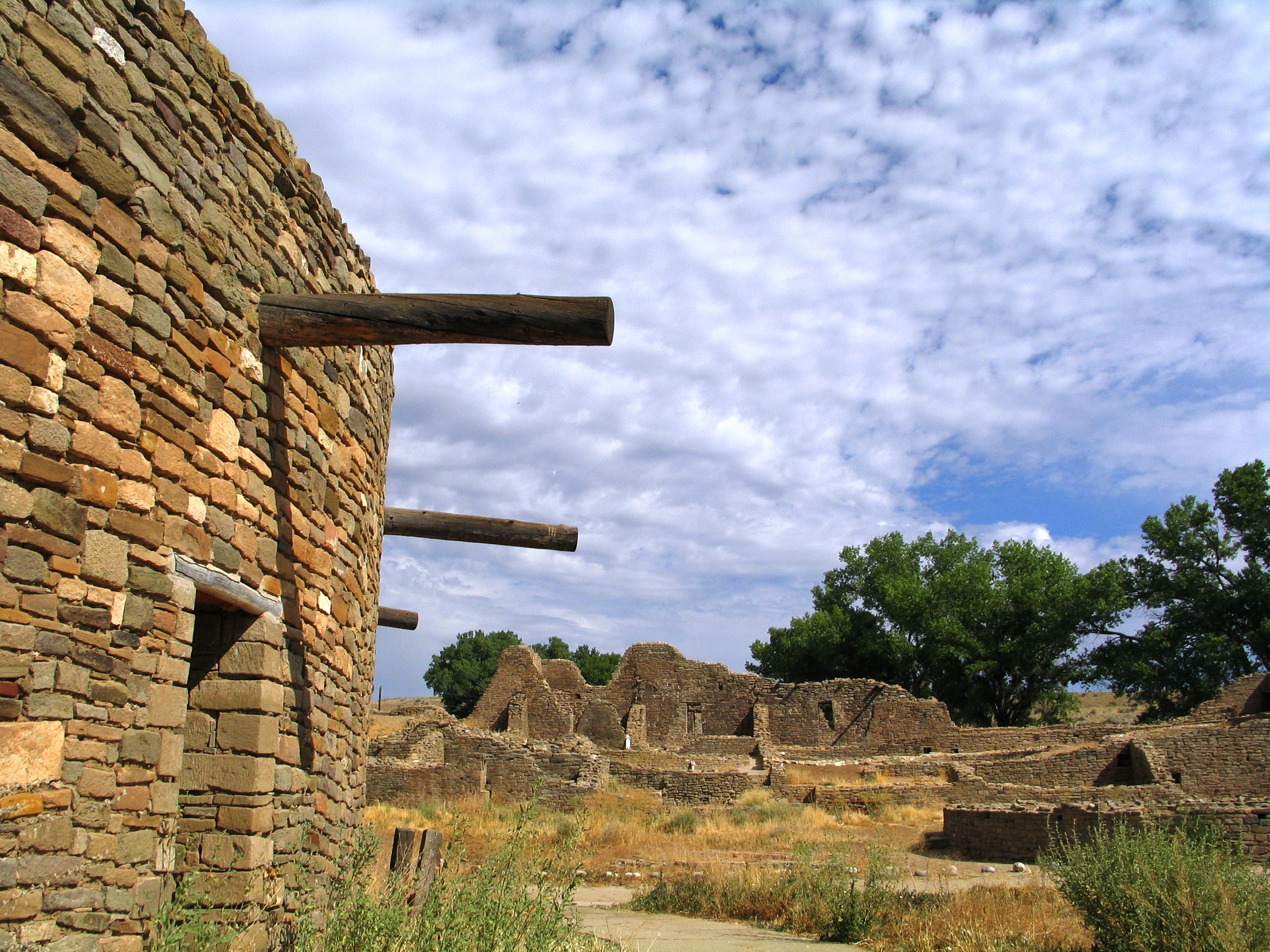
Aztec Ruins National Monument
National Monument
Aztec Ruins has some of the best-preserved Chacoan structures of its kind. Learn more about the ancestral Pueblo people in the park's museum and explore the Aztec West great house to see exceptionally...
10 mi from route
~24 min detour
Free
near mile 131
Park data from the National Park Service API. Alerts update every 2 hours.
More Details
What kind of drive is this?
Expect a highway-focused experience for the vast majority of this 131-mile trip, with 93% of the drive on main roads like US 491 and US 64. You'll encounter one substantial stretch of uninterrupted driving, covering 92.3 miles on US 491, so plan your breaks accordingly. The roads are designed for steady travel, making for a predictable and efficient journey. This isn't a route known for winding scenic byways, but rather for covering ground effectively.
93% highway — fuel and pacing are the main things to plan.
8 navigation steps total — most of the decisions cluster near the start and finish.
Longest single stretch: 92.3 mi on US 491.
How Hard Is This Drive?
1/10
This is a straightforward highway drive that stays mostly on US 491 and US 64. Navigation is very simple - set it and forget it for most of the drive. The trickiest moment comes early in the drive near NM 610 / South 2nd Street.
Driving Effort1/10
Very easy - short and simple to drive
Balances navigation complexity with total wheel time.
The drive from Gallup, NM to Lee Acres, NM is easy. At 2h 43m with 93% highway, most drivers will find it relaxed and low-stress.
Where does it get tricky?
The main spots that need attention: near the start (NM 610 / South 2nd Street): Navigation decision point; at 0.2 miles (NM 609 / West Maloney Avenue): Navigation decision point; at 1.2 miles (US 491): Navigation decision point.
Gallup is an important gateway to the Navajo Nation and other nearby attractions in the state of New Mexico. Gallup has numerous trading posts and Indian-themed gift shops, and an abundance of natural scenery surrounding town. In 2020, it was home to 22,000 people.
The longest stretch is about 92.3 miles on US 491. The full list of main roads is in the Roads section above.
Yes, with realistic expectations. Build in a stop roughly every 2 hours, have snacks and activities ready, and check the Nearby Places tabs for kid-friendly stops along the way.
Mostly yes along the main roads, but rural stretches through NM can have sparse or no coverage. Before you leave, download offline Google Maps or Apple Maps for the route, and consider downloading music or podcasts instead of streaming. If you depend on data for navigation, keep a paper backup of the turn-by-turn directions.
The main spots that need attention: near the start (NM 610 / South 2nd Street): Navigation decision point; at 0.2 miles (NM 609 / West Maloney Avenue): Navigation decision point; at 1.2 miles (US 491): Navigation decision point.
Yes — Aztec Ruins National Monument. See the National Parks section for detour distances and tips on detours.
Yes. A round trip is manageable in a single day if you plan a break at Lee Acres, NM before heading back.