Enchanted Hills, NM to Berino, NM is 264 miles and takes about 4h 40m via I 25 and US 550, with a fuel budget near $40 and enough daylight to finish in a day. This drive keeps you within the Desert Southwest, traversing New Mexico for its entirety. It's a straightforward trip primarily on major highways, making it a solid choice for a single-day journey. You'll find yourself on a highway-focused path for most of the 264 miles, so expect efficient travel. Consider this route if you're looking for a direct connection between these two points with minimal fuss.
Trip Pace
Same-day drive is realistic
A same-day return is possible, but it will make for a full day on the road.
Break Rhythm
1 planned break
Plan on a short reset every 3 to 4 hours to stay fresh behind the wheel.
Midpoint
132 miles from Enchanted Hills, NM
A natural place for your longest stop of the day
, about 2h 19m into the drive
.
Main Roads
Road
Distance
Duration
I 25
243.4 mi
4h 9m
Pearl Harbor Memorial Highway
9.4 mi
9m
US 550
2.8 mi
4m
Camino Real Street
2.3 mi
3m
Vado Road
1.5 mi
2m
Highway 478
1.4 mi
2m
Berino Road
0.8 mi
2m
Enchanted Hills Boulevard Northeast
0.6 mi
1m
Longest stretch:
I 25
— 243.4 mi, about 4h 9m
Traffic on I-25
Hour-of-day weekday pattern from 32 FHWA count stations on your route.
Peak
4 PM
~704 veh/hr typical
· worst 861
Quietest
2 AM
~57 veh/hr
Peak-to-quiet ratio
12.4×
busier at peak than in the quiet hours
12a6anoon6p11p
Averaged across 50 weeks of 2023 FHWA Travel Monitoring Analysis System data. Weekday hours only (Mon–Fri).
Turn-by-Turn Driving Directions
Step-by-step road directions between Enchanted Hills, NM and Berino, NM.
1
Start on Albany Hills Drive Northeast
247 ft·16 sec·Albany Hills Drive Northeast
2
Turn left onto Bismark Hills Way
253 ft·13 sec·Bismark Hills Way
3
Turn right onto Enchanted Hills Boulevard Northeast
0.6 mi·1 min·Enchanted Hills Boulevard Northeast
4
Turn left onto Safelite Road Northeast
0.3 mi·47 sec·Safelite Road Northeast
5
Continue on Safelite Boulevard Northeast
0.2 mi·34 sec·Safelite Boulevard Northeast
6
Turn right onto US 550
1.8 mi·3 min·US 550
7
Continue on US 550
0.1 mi·12 sec·US 550
Use the left lane.
8
Continue on US 550
0.9 mi·1 min·US 550
Use the right lane.
9
Take the exit
0.4 mi·46 sec
Toward I 25 South
10
Merge onto I 25
243 mi·4 hr 9 min·I 25
Use the straight / slight right lanes.
11
Merge onto I 10
9.4 mi·9 min·Pearl Harbor Memorial Highway
12
Take the exit
0.3 mi·36 sec
Toward Vado
13
Enter roundabout onto NM 227
156 ft·3 sec·Vado Road
14
Continue on NM 227
1.5 mi·2 min·Vado Road
15
Turn left onto Holguin Road
0.3 mi·49 sec·Holguin Road
16
Turn left onto NM 478
1.4 mi·2 min·Highway 478
17
Continue on NM 478
2.3 mi·3 min·Camino Real Street
18
Turn left onto Berino Road
0.8 mi·2 min·Berino Road
19
Turn left onto San Benito
0.2 mi·44 sec·San Benito
20
Arrive at destination
San Benito
Trip Plan
Given the 4h 40m duration, starting your drive in Enchanted Hills, NM, in the morning is recommended to allow ample time. With only one recommended stop, you can be strategic about when and where you choose to refuel or take a break. Keep an eye on your fuel levels, especially during the longest stretch on I 25, as services can sometimes be spread out in this region. The estimated fuel cost of $40 should be factored into your budget. Since this is a single-day trip, you have flexibility, but planning your departure time ensures you arrive in Berino, NM, with daylight to spare.
Morning Departure
An early start around 7-8 AM gets you there with plenty of daylight left.
Evening Departure
A late afternoon start means arriving after dark. Morning is better.
You can normally do this drive in one day.
Plan roughly 1 meaningful break for fuel, food, and rest.
The halfway point lands around 132 miles from Enchanted Hills, NM, or about 2h 19m into the drive.
The longest continuous stretch on this route runs about 243.4 miles.
This is a comfortable same-day trip.
Departure
Before you leave
Start with fuel, water, and navigation already sorted so the first hour feels easy.
First stop
Around 58 miles or 1h 3m in
Use this first pause for coffee, a restroom break, and a quick traffic check ahead.
Halfway reset
Around 132 miles or 2h 19m in
This is the best place for your longest stop, a real meal, and a full fuel check.
Final approach
Final hour starts around 3h 46m
Traffic, exits, and arrival timing usually matter more near Berino, NM than in the middle of the route.
Before You Leave
+
Open the route before leaving Enchanted Hills, NM so your first major turns are already loaded.
+
Leave with enough water and a charging cable within reach, not packed away.
+
Check your fuel range against the first long segment, especially if you are starting outside city service areas.
Day 1
Settle into the route from Enchanted Hills, NM
This is one driving day of about 264 miles and 4h 40m.
Your first comfortable stop window is around 58 miles from Enchanted Hills, NM.
This route can stay practical as a one-day drive if traffic stays reasonable.
Plan about 1 real break rather than only quick fuel stops.
The longest stretch is on I 25 for about 243.4 miles.
Where to Stop
Rest stops, refuel points, and overnight suggestions along this route.
Place data sourced from public business listings. Hours and availability may vary.
Heads-up: tricky spots
5 of 12
5 decision points cluster between mile 0 and 257.4 — GPS handles the exact turns, but know they're coming. Your lane choice matters more than the turn itself.
5
0 mi into trip|~0m in|Bismark Hills Way
Turn left onto Bismark Hills Way
Navigation decision point
4
0.1 mi into trip|~0m in|Enchanted Hills Boulevard Northeast
Turn right onto Enchanted Hills Boulevard Northeast
Navigation decision point
4
1.2 mi into trip|~3m in|US 550
Turn right onto US 550
Navigation decision point
5
4.4 mi into trip|~8m in|I 25
Merge onto I 25
Merge point - match speed before joining. Lane positioning matters here
Use the straight / slight right lanes.
5
257.4 mi into trip|~4h 28m in|NM 227 / Vado Road
Enter roundabout onto NM 227 / Vado Road
Roundabout - know your exit number before entering
Fuel & Cost
Regular Gas
$36.65 one way
$73.30 round trip
$3.53/gal25.4 MPG avg92 kg CO2
Fuel Type
$/gal
One Way
Round Trip
midgrade
$3.95
$41.00
$82.01
premium
$4.29
$44.58
$89.16
diesel
$4.80
$49.85
$99.70
No toll roads detected on this route.
Estimated Trip Cost (one way, 1 person)
Fuel
$37
Meals
$25–$50
Total
$62–$87
Rough estimate based on US averages. Hotel $80–$140/night, meals $25–$50/day.
Estimated CO2 emission: 92.4 kg one way.
Prices: EIA weekly data, 2026-07-13.
Driving Electric?
About $28 in charging
· 0 stops
· 66% less CO2
Vehicle Type
kWh
Stops
DC Fast
Home Charge
Average EV
79.2
0
$27.72
$12.67
Efficient EV
66
0
$23.10
$10.56
EV Truck/SUV
105.6
1
$36.96
$16.90
Gas CO2
92 kg
EV CO2
31 kg (66% less)
Plan for 0 charging stops, roughly every 270 miles. Allow 25-40 minutes per stop at a DC fast charger.
DC fast charging avg $0.35/kWh. Home charging avg $0.16/kWh. US grid CO2: 0.39 kg/kWh.
Travel Intel
Current conditions at both ends of the drive.
Forecast as of Jul 18, 2026
Origin
Enchanted Hills, NM
Late night
in Enchanted Hills on Sunday
Local time
4:09 AM
MDT
Current temp
64°F
Partly Cloudy
NW 5 mph7% chanceLive forecast
Flood Watch
Flood Watch issued July 17 at 8:50PM MDT until July 18 at 6:00PM MDT by NWS Albuquerque NM
Destination
Berino, NM
Late night
in Berino on Sunday
Local time
4:09 AM
MDT
Current temp
68°F
Chance Showers And Thunderstorms
W 3 mph39% chanceLive forecast
Flood Watch
Flood Watch issued July 17 at 8:50PM MDT until July 18 at 6:00PM MDT by NWS Albuquerque NM
Seasonal Notes
Summer travel usually means heavier construction, hotter rest stops, and busier weekend traffic around major cities.
Winter travel shortens daylight, so a route that looks manageable on paper can feel much longer after dark.
Holiday weekends tend to make both departure and arrival windows slower than the raw route time suggests.
Time zone
Same local time
Origin and destination are on the same clock, so arrival timing is easier to judge at a glance.
Temperature spread
4 degrees warmer at arrival
A meaningful temperature swing is a good cue to rethink layers, water, and how soon you want to arrive.
Road read
4h 40m on the road
An early start around 7-8 AM gets you there with plenty of daylight left.
Weather data from the National Weather Service. Conditions may change; check closer to your travel date.
National Parks Near This Route
Worth a detour if your schedule allows.
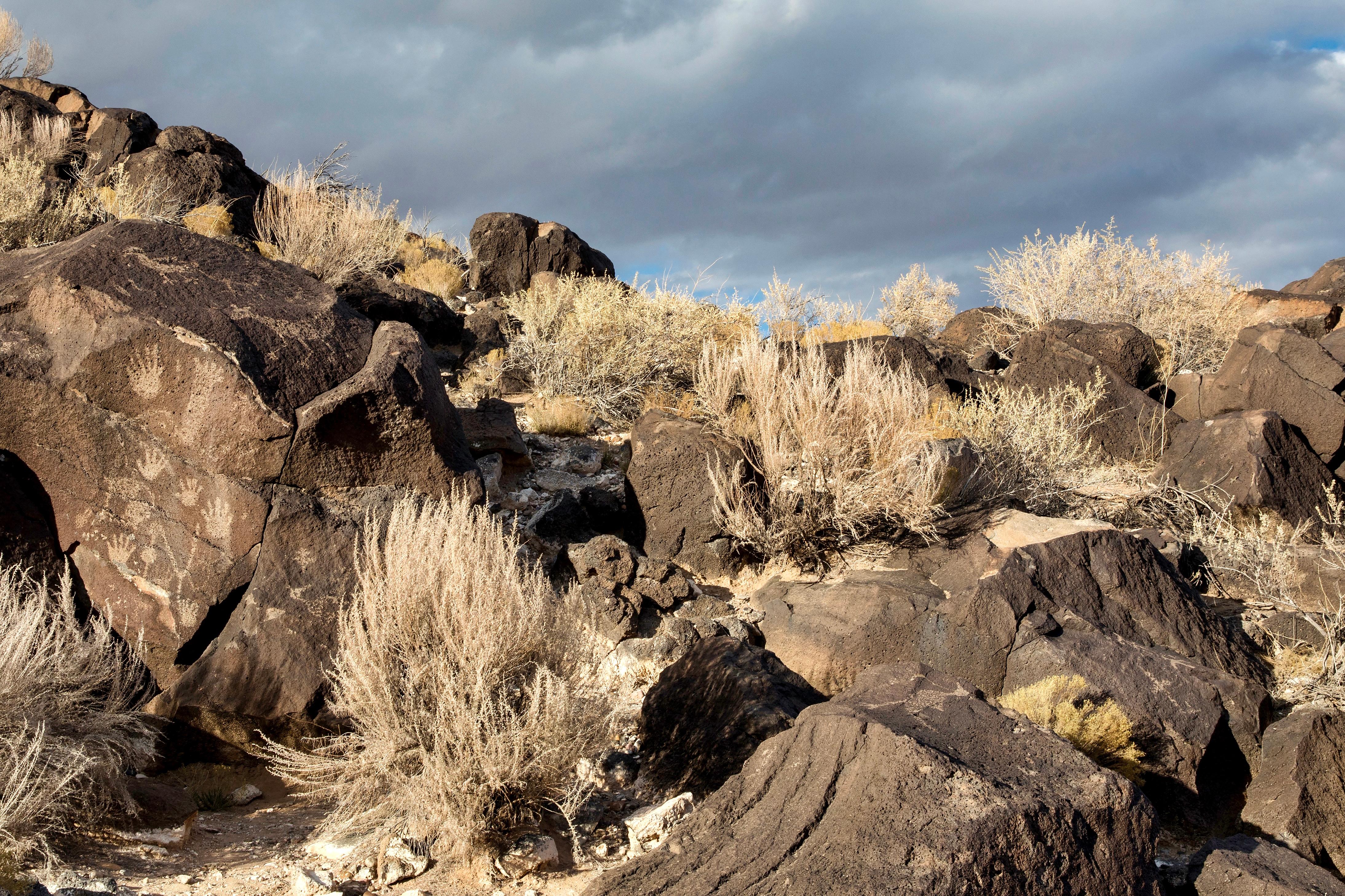
Petroglyph National Monument
National Monument
Petroglyph National Monument protects one of the largest petroglyph sites in North America, featuring designs and symbols carved onto volcanic rocks by Native Americans and Spanish settlers 400 to 700...
8 mi from route
~19 min detour
Free
near mile 18.2
Caution: Be City Smart: Take precautions to secure your vehicle and valuables.
Park data from the National Park Service API. Alerts update every 2 hours.
More Details
What kind of drive is this?
This route is overwhelmingly a highway-focused drive, with a 94% highway share. For the most part, you'll be on I 25, experiencing a long, uninterrupted stretch of 243.4 miles. This means consistent speeds and a predictable driving experience for the majority of your journey. While the primary roads include I 25 and US 550, the sheer length of time on the interstate defines the character of this drive. Expect open road conditions for extended periods, making it ideal for covering ground quickly.
94% highway — fuel and pacing are the main things to plan.
20 navigation steps total — most of the decisions cluster near the start and finish.
Longest single stretch: 243.4 mi on I 25.
How Hard Is This Drive?
4/10
This is a straightforward highway drive that stays mostly on I 25 and Pearl Harbor Memorial Highway. There are only a few real navigation decisions along the way. The trickiest moment comes early in the drive near Bismark Hills Way.
Driving Effort4/10
Easy - simple navigation with a manageable amount of wheel time
Balances navigation complexity with total wheel time.
This is a straightforward 4h 40m drive. You will face about 12 decision points, but nothing that requires special attention if you follow navigation.
Where does it get tricky?
The main spots that need attention: near the start (Bismark Hills Way): Navigation decision point; at 0.1 miles (Enchanted Hills Boulevard Northeast): Navigation decision point; at 1.2 miles (US 550): Navigation decision point.
The longest stretch is about 243.4 miles on I 25. The full list of main roads is in the Roads section above.
Yes — we found about 11 rest areas or service plazas within a short detour of the route (from OpenStreetMap). See the Rest Stops tab under Nearby Places for locations and mile markers. Plan to stretch, use the bathroom, and top off fluids every 2–3 hours on longer drives.
Yes, with realistic expectations. Build in a stop roughly every 2 hours, have snacks and activities ready, and check the Nearby Places tabs for kid-friendly stops along the way.
Mostly yes along the main roads, but rural stretches through NM can have sparse or no coverage. Before you leave, download offline Google Maps or Apple Maps for the route, and consider downloading music or podcasts instead of streaming. If you depend on data for navigation, keep a paper backup of the turn-by-turn directions.
The main spots that need attention: near the start (Bismark Hills Way): Navigation decision point; at 0.1 miles (Enchanted Hills Boulevard Northeast): Navigation decision point; at 1.2 miles (US 550): Navigation decision point.
Yes — Petroglyph National Monument. See the National Parks section for detour distances and tips on detours.
Possible but tiring. At 4.7 hours each way, an in-and-out day trip would put you behind the wheel for 9.3 hours — manageable with a long break at Berino, NM, but most travelers stay overnight.