Origin
Chinle, AZ
Evening in Chinle on Saturday
Local time
5:46 PM
MDT
Current temp
37°F
Unavailable
Live forecast
Compiled and reviewed by the US Trip Planner planning team at COD Solutions Oy · Last reviewed Apr 25, 2026 · Editorial standards
Drive Time
3h
Distance
135 mi
217 km
Drive Score
9/10
Great drive
Same Day?
Yes, doable
Fuel Cost
$27
one way
EV Charging
Unknown
Estimated drive times based on typical traffic patterns. Actual times may vary with weather, construction, and real-time conditions.

Chinle, AZ
Wikimedia Commons

Saint Johns, AZ
SHAHBAZ ZAMAN
Chinle, AZ to Saint Johns, AZ is 135 miles and takes about 3 hours via St. Johns-Sanders Highway and US 191, with a fuel budget near $27 and enough daylight to finish in a day. This trip stays within the Desert Southwest, offering a single-day excursion between two points in Arizona. You'll experience a mix of highway driving and surface roads, making it a straightforward but varied drive. Given its manageable length and duration, this route is ideal for a day trip, allowing for flexibility in your schedule.
Trip Pace
Same-day drive is realistic
A same-day return is realistic if you keep stops short.
Break Rhythm
1 planned break
A short stop every 2 to 3 hours is enough for this drive.
Midpoint
67.5 miles from Chinle, AZ
A natural place for your longest stop of the day , about 1h 39m into the drive .
| Road | Distance | Duration |
|---|---|---|
| St. Johns-Sanders Highway | 52.6 mi | 1h |
| US 191 | 44.1 mi | 1h 3m |
| Chambers-Mexican Water Highway | 30.9 mi | 46m |
| Purple Heart Trail | 5.3 mi | 5m |
| Navajo Route 7 | 1.6 mi | 2m |
| Cleveland Street | 0.3 mi | <1m |
| Main Street | 0.2 mi | <1m |
| 4th Avenue | <0.1 mi | <1m |
Step-by-step road directions between Chinle, AZ and Saint Johns, AZ.
Start on 4th Avenue
Turn left onto Main Street
At end of road, turn right onto N7
At end of road, turn left onto US 191
Enter roundabout onto US 191
Continue on US 191
Turn right onto US 191
Continue on US 191
Take the ramp onto US 191
Merge onto I 40; US 191
Take the exit onto US 191
Turn right onto US 191
Continue on US 191; AZ 61
Turn left onto US 180; US 191
Arrive at destination
Starting from Chinle, AZ, aim to depart in the morning to take advantage of the full day for your 135-mile drive, which should take around 3 hours. With only one recommended stop, you have flexibility in pacing your journey. Keep an eye on your fuel gauge, as the estimated cost is $27, and plan your refueling accordingly, especially since you'll be on surface roads for a significant portion. The longest stretch without a stop is over 50 miles, so ensure you're comfortable with that before setting off.
Morning Departure
An early start around 7-8 AM gets you there with plenty of daylight left.
Evening Departure
A late afternoon start means arriving after dark. Morning is better.
This is a comfortable same-day trip.
Departure
Before you leave
Start with fuel, water, and navigation already sorted so the first hour feels easy.
First stop
Around 30 miles or 45m in
Use this first pause for coffee, a restroom break, and a quick traffic check ahead.
Halfway reset
Around 67.5 miles or 1h 39m in
This is the best place for your longest stop, a real meal, and a full fuel check.
Final approach
Final hour starts around 2h 31m
Traffic, exits, and arrival timing usually matter more near Saint Johns, AZ than in the middle of the route.
Open the route before leaving Chinle, AZ so your first major turns are already loaded.
Leave with enough water and a charging cable within reach, not packed away.
Check your fuel range against the first long segment, especially if you are starting outside city service areas.
Day 1
Settle into the route from Chinle, AZ
This is one driving day of about 135 miles and 3h.
Rest stops, refuel points, and overnight suggestions along this route.

Mid-route town
Meal stop
68 mi into the route
Best for: Lunch, fuel, and a longer reset
This sits close to the middle of the route, so it works well for the longest stop of the day.
A short stop after about 30 miles helps settle the day before fatigue starts building.
The midpoint is around 67.5 miles from Chinle, AZ, which is a good place for a longer meal and fuel stop.
These stop ideas are pacing suggestions — the exact town or exit can change with traffic, hotel plans, and fuel range.
5 decision points cluster between mile 0 and 135 — GPS handles the exact turns, but know they're coming. Your lane choice matters more than the turn itself.
Turn left onto Main Street
Navigation decision point
At end of road, turn right onto N7 / Navajo Route 7
Navigation decision point
At end of road, turn left onto US 191 / Chambers-Mexican Water Highway
Lane positioning matters here
Enter roundabout onto US 191
Roundabout - know your exit number before entering
Turn left onto US 180; US 191 / White Mountain Drive
Navigation decision point
Regular Gas
$26.75 one way
$53.50 round trip
| Fuel Type | $/gal | One Way | Round Trip |
|---|---|---|---|
| midgrade | $5.33 | $28.35 | $56.70 |
| premium | $5.56 | $29.55 | $59.10 |
| diesel | $5.40 | $28.72 | $57.43 |
No toll roads detected on this route.
Estimated Trip Cost (one way, 1 person)
Fuel
$27
Meals
$25–$50
Total
$52–$77
Rough estimate based on US averages. Hotel $80–$140/night, meals $25–$50/day.
Estimated CO2 emission: 47.2 kg one way. Prices: EIA weekly data, 2026-04-20.
Driving Electric?
About $14 in charging · 0 stops · 66% less CO2
| Vehicle Type | kWh | Stops | DC Fast | Home Charge |
|---|---|---|---|---|
| Average EV | 40.5 | 0 | $14.17 | $6.48 |
| Efficient EV | 33.8 | 0 | $11.81 | $5.40 |
| EV Truck/SUV | 54 | 0 | $18.90 | $8.64 |
Gas CO2
47 kg
EV CO2
16 kg (66% less)
This trip is well within single-charge range for most EVs. No charging stops needed if you start fully charged.
DC fast charging avg $0.35/kWh. Home charging avg $0.16/kWh. US grid CO2: 0.39 kg/kWh.
Current conditions at both ends of the drive.
Origin
Evening in Chinle on Saturday
Local time
5:46 PM
MDT
Current temp
37°F
Unavailable
Destination
Afternoon in Saint Johns on Saturday
Local time
4:46 PM
MST
Current temp
70°F
Unavailable
Seasonal Notes
Summer travel usually means heavier construction, hotter rest stops, and busier weekend traffic around major cities.
Winter travel shortens daylight, so a route that looks manageable on paper can feel much longer after dark.
Holiday weekends tend to make both departure and arrival windows slower than the raw route time suggests.
Time zone
The destination clock does not match departure time, so double-check hotel check-in windows and late arrival plans.
Temperature spread
A meaningful temperature swing is a good cue to rethink layers, water, and how soon you want to arrive.
Road read
Use the two city cards together: check the sky where you start, then compare it with the local time and temperature at arrival.
Weather data from the National Weather Service. Conditions may change; check closer to your travel date.
Worth a detour if your schedule allows.
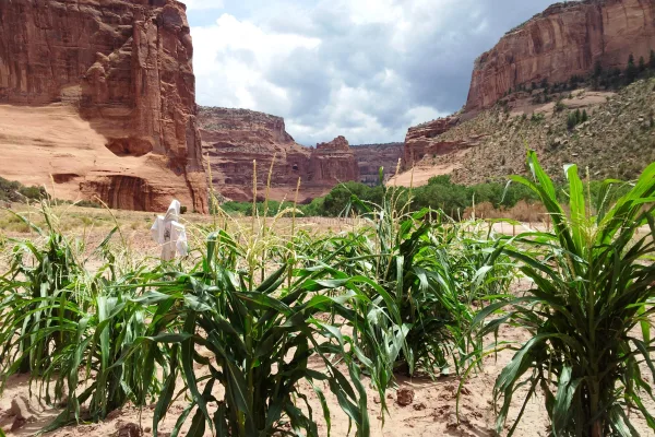
National Monument
This canyon is home to Diné families who raise livestock, grow crops and live here. People have lived in these canyons for nearly 5,000 years, which is longer than anyone has lived continuously on the...

National Park
A landscape where deep time lies fully on display, Petrified Forest National Park blends colorful badlands, vast grasslands, and one of the world’s largest and most vivid collections of petrified wood...
Park data from the National Park Service API. Alerts update every 2 hours.
This drive is about 34% highway, with the longest continuous stretch on the St. Johns-Sanders Highway covering 52.6 miles. The remaining portion of your trip will be on surface roads, indicating a shift from faster-paced driving to more rural cruising. You'll notice the change in road type as you transition between these sections. The mix means you'll have periods of steady travel followed by sections that require more attention to speed and surroundings.
This route mixes highway mileage with some local-road sections near the start or finish. Navigation is very simple - set it and forget it for most of the drive. The trickiest moment comes early in the drive near Main Street.
Very easy - short and simple to drive
Balances navigation complexity with total wheel time.
The drive from Chinle, AZ to Saint Johns, AZ is easy. At 3h with 34% highway, most drivers will find it relaxed and low-stress.
Where does it get tricky?
The main spots that need attention: near the start (Main Street): Navigation decision point; at 0.3 miles (N7 / Navajo Route 7): Navigation decision point; at 1.9 miles (US 191 / Chambers-Mexican Water Highway): Lane positioning matters here.
Canyon de Chelly National Monument (duh-SHAY) is a national monument within the Navajo Nation in Northern Arizona. The park preserves ruins of the indigenous tribes that lived in the area, from the Ancestral Puebloans (formerly known as Anasazi) to the Navajo, and reflects one of the longest continuously inhabited landscapes of North America.
City content from Wikivoyage (CC BY-SA 4.0) and Wikidata (CC0).
Weekend Trip
Doable as a same-day drive at 3h. Total distance: 135 miles.
Family Friendly
Moderate complexity with 1 natural rest stops along the way.
Solo Traveler
3h drive, comfortable solo distance.
First-Time Driver
Mostly highway driving (34%). Straightforward navigation.
Scenic Drive
Mixed highway & surface route profile with national parks nearby.
Compiled by the US Trip Planner planning team at COD Solutions Oy from open government datasets — OSRM over OpenStreetMap for geometry, EIA for fuel prices, and NPS for national parks. See our methodology for refresh cadence and limitations.
Was this helpful?
Thanks for your feedback!
Your tip has been submitted. Thanks!
/500
Recent Tips
·
Explore more options from Chinle, AZ or browse trips ending in Saint Johns, AZ.
Looking for more statewide routes? Browse AZ road trips.