If you are planning a journey from Cabool to Independence, Missouri, expect a straightforward trip covering 238.8 miles. You should budget approximately 4 hours and 51 minutes of driving time, making this a manageable excursion for a single day. With a fuel cost of roughly $36, it is an affordable route to navigate across the Midwest. While you could easily complete the drive in one go, you might consider a single strategic stop to break up the time behind the wheel. Given the duration, this route is ideal for those who prefer an efficient, highway-focused path rather than a scenic, winding detour.
Trip Pace
Same-day drive is realistic
A same-day return is possible, but it will make for a full day on the road.
Break Rhythm
1 planned break
Plan on a short reset every 3 to 4 hours to stay fresh behind the wheel.
Midpoint
119.4 miles from Cabool, MO
A natural place for your longest stop of the day
, about 2h 22m into the drive
.
Main Roads
Road
Distance
Duration
North Kansas Expressway
87.2 mi
1h 42m
US 60
66.6 mi
1h 17m
MO 7
39.2 mi
43m
South Noland Road
8.9 mi
15m
MO 58
8.5 mi
11m
MO 291
8.3 mi
12m
Schoolcraft Freeway
8.1 mi
10m
Payne Stewart Highway
4.1 mi
5m
Longest stretch:
North Kansas Expressway
— 87.2 mi, about 1h 42m
Turn-by-Turn Driving Directions
Step-by-step road directions between Cabool, MO and Independence, MO.
1
Start on this road
120 ft·10 sec·this road
2
Turn right onto US 60 Business
0.1 mi·20 sec·Ozark Street
3
Turn left onto MO 181
0.2 mi·20 sec·South Elm Street
4
Continue on MO 181
0.3 mi·36 sec·Peabody Avenue
5
Take the ramp
0.2 mi·20 sec
Toward US 60 West: Mountain Grove
6
Merge onto US 60
67 mi·1 hr 17 min·US 60
7
Take the exit
0.3 mi·32 sec
Toward US 65 North: Sedalia
8
Merge onto US 65
8.1 mi·10 min·Schoolcraft Freeway
9
Take the exit
0.8 mi·1 min
Toward I 44 West: Joplin
10
Merge onto I 44
4.1 mi·5 min·Payne Stewart Highway
11
Take the exit
0.1 mi·14 sec
Exit 77Toward MO 13: Bolivar
12
Keep slight left at fork
150 ft·3 sec
Exit 77Toward MO 13: Bolivar
13
Keep slight right at fork
209 ft·7 sec
Exit 77Toward MO 13 North: Bolivar
14
Merge onto MO 13
87 mi·1 hr 42 min·North Kansas Expressway
Use the left / straight lanes.
15
Continue on MO 7
36 mi·39 min·MO 7
16
Take the exit onto MO 7
3.3 mi·3 min·MO 7
Toward I 49 North, US 71 North, MO 7 North: Kansas City
17
Take the exit
0.2 mi·17 sec
Exit 160Toward MO 291 North: Lee's Summit
18
Keep slight right at fork
243 ft·6 sec
Toward MO 291 North: Lee's Summit
19
Merge onto MO 291
8.3 mi·12 min·MO 291
20
Turn slight left onto MO 58; MO 291
8.5 mi·11 min·MO 58; MO 291
21
Continue on Southwest Jefferson Street
0.2 mi·23 sec·Southwest Jefferson Street
22
Take the exit
0.2 mi·20 sec
Toward US 50 West: Kansas City
23
Merge onto US 50
2.7 mi·3 min·US 50
24
Continue on MO 350
2.5 mi·3 min·Blue Parkway
25
Turn right onto MO V
5.9 mi·9 min·South Noland Road
26
Continue on South Noland Road
3.1 mi·5 min·South Noland Road
27
Turn left onto East Walnut Street
466 ft·22 sec·East Walnut Street
28
Turn right onto South Lynn Street
394 ft·22 sec·South Lynn Street
29
Turn left onto East Kansas Avenue
145 ft·6 sec·East Kansas Avenue
30
Arrive at destination
East Kansas Avenue
Trip Plan
For the smoothest experience, plan to depart early in the day to navigate the 238.8-mile distance without feeling rushed. Since the route includes one recommended stop, look for a convenient location midway to stretch your legs and refuel your vehicle. Keep the $36 fuel budget in mind as you plan your stops, and ensure your tank is topped off before hitting the longer highway sections. Because the route is compact enough for a single day, you have the flexibility to adjust your departure time based on local traffic patterns. Utilizing the North Kansas Expressway effectively is key to maintaining your pace, so stay alert for merging traffic during that 87.2-mile stretch.
Morning Departure
An early start around 7-8 AM gets you there with plenty of daylight left.
Evening Departure
A late afternoon start means arriving after dark. Morning is better.
You can normally do this drive in one day.
Plan roughly 1 meaningful break for fuel, food, and rest.
The halfway point lands around 119.4 miles from Cabool, MO, or about 2h 22m into the drive.
The longest continuous stretch on this route runs about 87.2 miles.
This is a comfortable same-day trip.
Departure
Before you leave
Start with fuel, water, and navigation already sorted so the first hour feels easy.
First stop
Around 53 miles or 1h 2m in
Use this first pause for coffee, a restroom break, and a quick traffic check ahead.
Halfway reset
Around 119.4 miles or 2h 22m in
This is the best place for your longest stop, a real meal, and a full fuel check.
Final approach
Final hour starts around 3h 50m
Traffic, exits, and arrival timing usually matter more near Independence, MO than in the middle of the route.
Before You Leave
+
Open the route before leaving Cabool, MO so your first major turns are already loaded.
+
Leave with enough water and a charging cable within reach, not packed away.
+
Check your fuel range against the first long segment, especially if you are starting outside city service areas.
Day 1
Settle into the route from Cabool, MO
This is one driving day of about 238.8 miles and 4h 51m.
Your first comfortable stop window is around 53 miles from Cabool, MO.
This route can stay practical as a one-day drive if traffic stays reasonable.
Plan about 1 real break rather than only quick fuel stops.
The longest stretch is on North Kansas Expressway for about 87.2 miles.
Where to Stop
Rest stops, refuel points, and overnight suggestions along this route.
First break
4.3 mi from route
~11 min detour
$20 to $30
Mountain Grove, Missouri
Hours: 4–9 pm
+14179269954
Place data sourced from public business listings. Hours and availability may vary.
Heads-up: tricky spots
5 of 21
5 decision points cluster between mile 0 and 207.3 — GPS handles the exact turns, but know they're coming. Your lane choice matters more than the turn itself.
5
0 mi into trip|~0m in|US 60 Business / Ozark Street
Turn right onto US 60 Business / Ozark Street
Navigation decision point
6
0.7 mi into trip|~1m in
Take the ramp toward US 60 West: Mountain Grove
Complex interchange - multiple decisions in a short stretch
Toward US 60 West: Mountain Grove
7
80.7 mi into trip|~1h 37m in
Keep slight left at fork toward MO 13: Bolivar
Highway fork - watch signs carefully
Exit 77
Toward MO 13: Bolivar
7
80.8 mi into trip|~1h 37m in
Keep slight right at fork toward MO 13 North: Bolivar
Highway fork - watch signs carefully
Exit 77
Toward MO 13 North: Bolivar
6
207.3 mi into trip|~4h 3m in
Keep slight right at fork toward MO 291 North: Lee's Summit
Highway fork - watch signs carefully
Toward MO 291 North: Lee's Summit
Fuel & Cost
Regular Gas
$35.27 one way
$70.53 round trip
$3.75/gal25.4 MPG avg84 kg CO2
Fuel Type
$/gal
One Way
Round Trip
midgrade
$4.14
$38.93
$77.86
premium
$4.72
$44.34
$88.68
diesel
$4.80
$45.09
$90.18
No toll roads detected on this route.
Estimated Trip Cost (one way, 1 person)
Fuel
$35
Meals
$25–$50
Total
$60–$85
Rough estimate based on US averages. Hotel $80–$140/night, meals $25–$50/day.
Estimated CO2 emission: 83.6 kg one way.
Prices: EIA weekly data, 2026-07-13.
Driving Electric?
About $25 in charging
· 0 stops
· 67% less CO2
Vehicle Type
kWh
Stops
DC Fast
Home Charge
Average EV
71.6
0
$25.07
$11.46
Efficient EV
59.7
0
$20.90
$9.55
EV Truck/SUV
95.5
1
$33.43
$15.28
Gas CO2
84 kg
EV CO2
28 kg (67% less)
Plan for 0 charging stops, roughly every 270 miles. Allow 25-40 minutes per stop at a DC fast charger.
DC fast charging avg $0.35/kWh. Home charging avg $0.16/kWh. US grid CO2: 0.39 kg/kWh.
Travel Intel
Current conditions at both ends of the drive.
Forecast as of Jul 18, 2026
Origin
Cabool, MO
Late night
in Cabool on Sunday
Local time
1:41 AM
CDT
Current temp
89°F
Slight Chance Showers And Thunderstorms
W 5 to 9 mph19% chanceLive forecast
Heat Advisory
Heat Advisory issued July 18 at 4:25AM CDT until July 18 at 8:00PM CDT by NWS Memphis TN
Heat Advisory
Heat Advisory issued July 18 at 3:04AM CDT until July 21 at 7:00PM CDT by NWS St Louis MO
Destination
Independence, MO
Late night
in Independence on Sunday
Local time
1:41 AM
CDT
Current temp
92°F
Slight Chance Rain Showers then Slight Chance Showers And Thunderstorms
SW 5 to 8 mph20% chanceLive forecast
Heat Advisory
Heat Advisory issued July 18 at 4:25AM CDT until July 18 at 8:00PM CDT by NWS Memphis TN
Heat Advisory
Heat Advisory issued July 18 at 3:04AM CDT until July 21 at 7:00PM CDT by NWS St Louis MO
Seasonal Notes
Summer travel usually means heavier construction, hotter rest stops, and busier weekend traffic around major cities.
Winter travel shortens daylight, so a route that looks manageable on paper can feel much longer after dark.
Holiday weekends tend to make both departure and arrival windows slower than the raw route time suggests.
Time zone
Same local time
Origin and destination are on the same clock, so arrival timing is easier to judge at a glance.
Temperature spread
3 degrees warmer at arrival
A meaningful temperature swing is a good cue to rethink layers, water, and how soon you want to arrive.
Road read
4h 51m on the road
An early start around 7-8 AM gets you there with plenty of daylight left.
Weather data from the National Weather Service. Conditions may change; check closer to your travel date.
National Parks Near This Route
Worth a detour if your schedule allows.
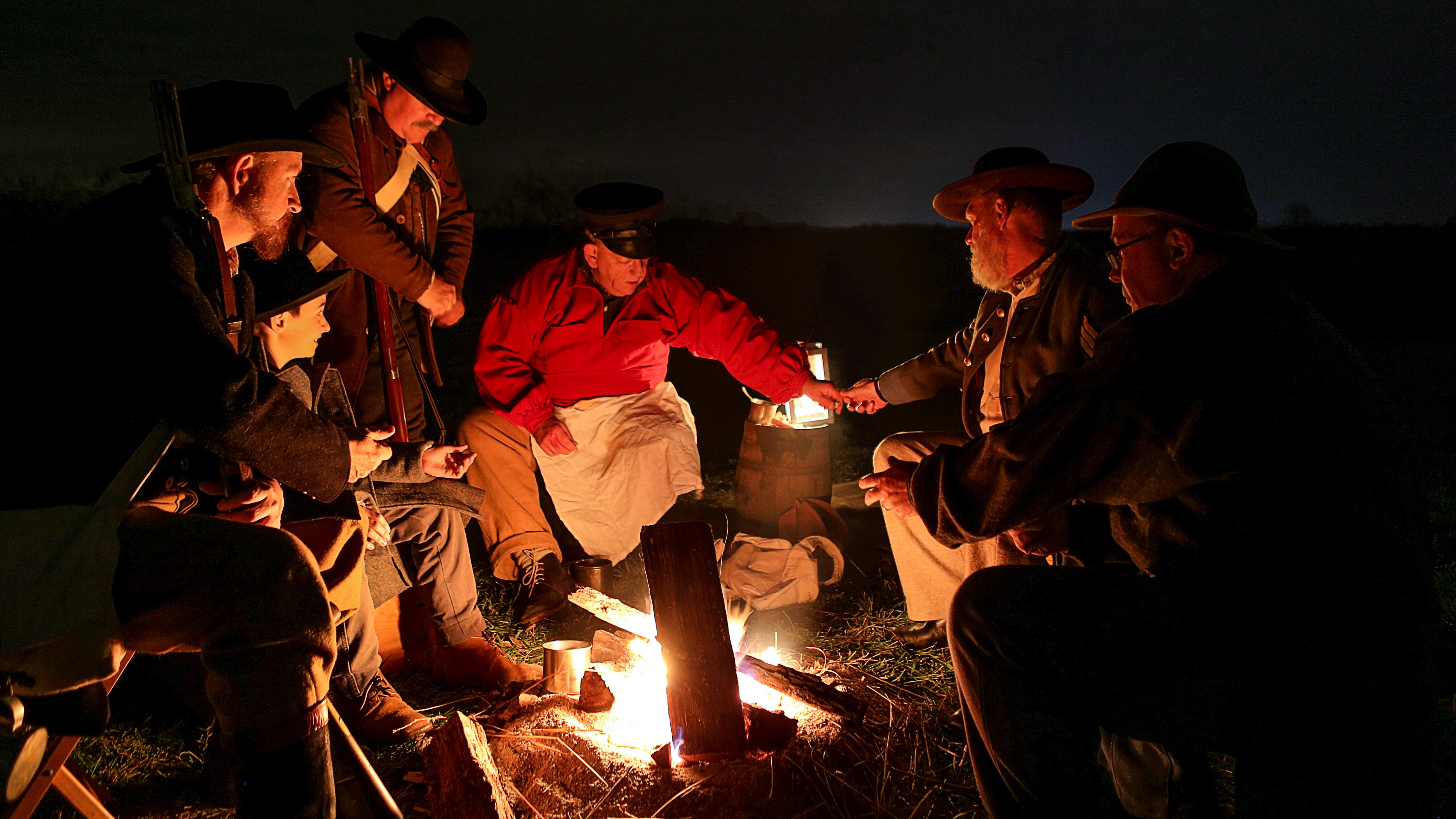
Wilson's Creek National Battlefield
National Battlefield
Wilson's Creek was the first major Civil War battle fought west of the Mississippi River, and where the first Union general was killed in action. The costly Southern victory on August 10, 1861, focuse...
11 mi from route
~28 min detour
Free
near mile 65.9
Park data from the National Park Service API. Alerts update every 2 hours.
More Details
What kind of drive is this?
This trip is heavily highway-focused, with 93% of the journey taking place on major thoroughfares. You will navigate via the North Kansas Expressway, US 60, and MO 7, experiencing a consistent rhythm throughout the drive. Be prepared for the longest uninterrupted stretch, which spans 87.2 miles along the North Kansas Expressway. The road character remains relatively uniform as you transition between these key routes, offering a reliable surface for most of your travel. You can expect a steady, predictable pace that prioritizes speed and directness over technical maneuvers.
93% highway — fuel and pacing are the main things to plan.
30 navigation steps total — most of the decisions cluster near the start and finish.
Longest single stretch: 87.2 mi on North Kansas Expressway.
How Hard Is This Drive?
9/10
This is a straightforward highway drive that stays mostly on North Kansas Expressway and US 60. This route has several spots where lane changes, forks, or exits need your full attention. The trickiest moment comes early in the drive near US 60 Business / Ozark Street.
Driving Effort9/10
High effort - long or complex enough to need steady focus all day
Balances navigation complexity with total wheel time.
This is a demanding drive. With 21 significant decision points across 238.8 miles, you will need to stay alert - especially through interchange areas and urban stretches. Consider splitting it into segments if you are not comfortable with fast highway navigation.
Where does it get tricky?
The main spots that need attention: near the start (US 60 Business / Ozark Street): Navigation decision point; at 0.7 miles: Complex interchange - multiple decisions in a short stretch; at 80.7 miles: Highway fork - watch signs carefully.
Independence, known as the Queen City of the Trails, is a city in western Missouri just east of Kansas City with a population of approximately 110,000. Independence's founding predates that of Kansas City, and it was home to U.S. President Harry S. Truman and the legendary actress Ginger Rogers, as well as the starting point of three of America's great Westward Trails: the Santa Fe Trail, the California Trail, and the Oregon Trail. The city also hosts numerous historical sites related to the Community of Christ (formerly RLDS), Church of Jesus Christ of Latter-day Saints (the "Mormons"), American Civil War and Western history.
While offering a full range of entertainment and lodging options for visitors, Independence generally tends to be more "quiet" than its larger neighbor to the west.
Top landmarks
•Harry S. Truman Presidential Library and Museum — presidential library and museum for U.S. President Harry S. Truman, located in I...
•Temple Lot — Geographical location important in Latter Day Saint history
•Harry S. Truman National Historic Site — national Historic Site of the United States in Missouri
Doable as a same-day drive at 4h 51m. Total distance: 238.8 miles.
Family Friendly
Moderate complexity with 1 natural rest stops along the way.
Solo Traveler
4h 51m drive, comfortable solo distance.
First-Time Driver
Mostly highway driving (93%). Some complex stretches to watch for.
Frequently Asked Questions
The longest stretch is about 87.2 miles on North Kansas Expressway. The full list of main roads is in the Roads section above.
Yes — we found about 6 rest areas or service plazas within a short detour of the route (from OpenStreetMap). See the Rest Stops tab under Nearby Places for locations and mile markers. Plan to stretch, use the bathroom, and top off fluids every 2–3 hours on longer drives.
It helps. This route has a higher-than-average number of complex decision points, which get harder in the dark. If the last hour of the trip is on surface roads or mountain grades, aim to arrive at Independence, MO before sunset when you can. Check the Trip Plan for departure windows that land you in daylight.
Only with planning. This is a long drive for kids — consider splitting it into two days rather than pushing through. Plan at least 1 meaningful breaks. There are 6 rest areas along the route for bathroom stops.
The main spots that need attention: near the start (US 60 Business / Ozark Street): Navigation decision point; at 0.7 miles: Complex interchange - multiple decisions in a short stretch; at 80.7 miles: Highway fork - watch signs carefully.
Yes — Wilson's Creek National Battlefield. See the National Parks section for detour distances and tips on detours.
Possible but tiring. At 4.9 hours each way, an in-and-out day trip would put you behind the wheel for 9.7 hours — manageable with a long break at Independence, MO, but most travelers stay overnight.