Buxton, NC to Charlotte, NC is 398.7 miles and takes about 8h 13m via I 85, US 64, and US 13, with a fuel budget near $61 and enough daylight to finish in a day. This trip stays within North Carolina, moving from the Southeast region to another part of the Southeast. Given the duration, it's a substantial drive, making it best suited for an overnight trip rather than a single day. You'll spend most of your time on major highways, so expect a straightforward transit between these two points.
Trip Pace
Best split across 2 days
Treat the return leg as its own travel day rather than an afterthought.
Break Rhythm
2 planned breaks
Plan on a short reset every 3 to 4 hours to stay fresh behind the wheel.
Midpoint
199.4 miles from Buxton, NC
A natural place for your longest stop of the day
, about 4h 20m into the drive
.
Main Roads
Road
Distance
Duration
I 85
119.3 mi
2h 13m
US 64
67.3 mi
1h 27m
US 13
58.3 mi
1h 3m
US 64 Bypass
27.8 mi
29m
North Carolina Highway 12
24.6 mi
42m
NC 12
23.6 mi
33m
Washington Baum Bridge
20.7 mi
27m
Northern Wake Expressway
15.4 mi
16m
Longest stretch:
I 85
— 119.3 mi, about 2h 13m
Traffic on I-85
Hour-of-day weekday pattern from 22 FHWA count stations on your route.
Peak
5 PM
~4,986 veh/hr typical
Quietest
2 AM
~457 veh/hr
Peak-to-quiet ratio
10.9×
busier at peak than in the quiet hours
12a6anoon6p11p
Averaged across 52 weeks of 2023 FHWA Travel Monitoring Analysis System data. Weekday hours only (Mon–Fri).
Turn-by-Turn Driving Directions
Step-by-step road directions between Buxton, NC and Charlotte, NC.
1
Start on this road
12 ft·4 sec·this road
2
Turn left
99 ft·8 sec
3
Turn right onto NC 12
25 mi·42 min·North Carolina Highway 12
Use the straight / right lanes.
4
Enter roundabout onto NC 12
194 ft·3 sec·NC 12
5
Continue on NC 12
24 mi·33 min·NC 12
6
Turn left onto US 64; SR 1521
1.5 mi·2 min·South Virginia Dare Trail
7
Continue on US 64
21 mi·27 min·Washington Baum Bridge
8
Keep slight left at fork onto US 64
67 mi·1 hr 27 min·US 64
Use the straight lane.
9
Turn left onto US 13; US 17
1.8 mi·2 min·US 13; US 17
10
Continue on US 13; US 64
57 mi·1 hr 1 min·US 13; US 64
11
Continue on US 64 Bypass
28 mi·29 min·US 64 Bypass
12
Take the exit
0.2 mi·28 sec
Exit 14Toward Rolesville Road
13
Keep slight right at fork
309 ft·7 sec
Exit 14Toward Rolesville Road
14
Turn right onto Rolesville Road
2.4 mi·4 min·Rolesville Road
15
Turn sharp left onto Marks Creek Road
0.4 mi·38 sec·Marks Creek Road
16
Turn right onto Horton Road
0.4 mi·43 sec·Horton Road
17
Turn right onto Buffaloe Road
3.8 mi·6 min·Buffaloe Road
Use the straight / right lanes.
18
Take the ramp
0.4 mi·23 sec
19
Merge onto I 540
15 mi·16 min·Northern Wake Expressway
Use the straight lane.
20
Take the exit
0.6 mi·1 min
Toward US 70 West: DurhamUse the straight / slight right lanes.
21
Merge onto US 70
1.9 mi·2 min·Glenwood Avenue
Use the straight lane.
22
Continue on US 70
2.5 mi·3 min·New Raleigh Highway
23
Continue on US 70
9.3 mi·12 min·South Miami Boulevard
Use the left / straight lanes.
24
Keep slight left at fork onto I 85; US 70
42 mi·48 min·I 85; US 70
Use the straight / slight right lanes.
25
Keep slight right at fork onto I 40
7.7 mi·9 min·I 40
Use the straight / slight left lanes.
26
Keep slight left at fork onto US 29
5.4 mi·5 min·US 29
Toward I 85 Business South, US 29 South, US 70 West: CharlotteUse the left lane.
27
Keep slight left at fork onto I 85
77 mi·1 hr 24 min·I 85
Use the straight / slight right lanes.
28
Take the exit
0.1 mi·25 sec
Exit 41Toward Sugar Creek RoadUse the slight right lane.
29
Turn left onto West Sugar Creek Road
1.5 mi·2 min·West Sugar Creek Road
Use the left / straight lanes.
30
Turn right onto US 29; NC 49
1.4 mi·2 min·North Tryon Street
Use the straight / right lanes.
31
Continue on US 29; NC 49
0.7 mi·1 min·North Church Street
32
Continue on US 29; NC 49
1.5 mi·2 min·North Tryon Street
33
Arrive at destination
South Tryon Street
Trip Plan
This 398.7-mile drive is best split over two days to avoid a very long single-day commitment. Aim to depart early in the morning from Buxton to maximize daylight, especially if you choose to drive it in one go. With a total duration of over 8 hours, plan for at least one significant stop for fuel and a meal. Given the 88% highway share, the 119.3-mile stretch on I 85 is a good candidate for your longest driving segment between planned breaks. Keep an eye on your fuel gauge, as the budget is estimated at $61, and services can be spaced out on some highway sections.
Morning Departure
Start early — leave by 6-7 AM to arrive at a reasonable hour.
Evening Departure
This is a long drive — plan for a morning departure or consider splitting it into two days.
This drive is better paced as a 2-day trip.
Plan roughly 2 meaningful breaks for fuel, food, and rest.
The halfway point lands around 199.4 miles from Buxton, NC, or about 4h 20m into the drive.
The longest continuous stretch on this route runs about 119.3 miles.
Consider an overnight stop or starting very early.
Departure
Before you leave
Start with fuel, water, and navigation already sorted so the first hour feels easy.
First stop
Around 88 miles or 2h 8m in
Use this first pause for coffee, a restroom break, and a quick traffic check ahead.
Halfway reset
Around 199.4 miles or 4h 20m in
This is the best place for your longest stop, a real meal, and a full fuel check.
Overnight split
Day 1 wrap after about 199.4 miles or 4h 20m
Stop before fatigue turns the last few hours into a grind. You want day two to start fresh, not just resumed.
Final approach
Final hour starts around 7h 4m
Traffic, exits, and arrival timing usually matter more near Charlotte, NC than in the middle of the route.
Before You Leave
+
Open the route before leaving Buxton, NC so your first major turns are already loaded.
+
Leave with enough water and a charging cable within reach, not packed away.
+
Check your fuel range against the first long segment, especially if you are starting outside city service areas.
+
Pick one backup stop option before the midpoint in case traffic changes your pacing.
+
Treat this as a 2-day road trip and book the overnight stop before the busiest arrival window.
Day 1
Settle into the route from Buxton, NC
Aim for roughly 199 miles and 4.1 hours of wheel time on this day.
Day 2
Finish the approach into Charlotte, NC
Aim for roughly 199 miles and 4.1 hours of wheel time on this day.
Your first comfortable stop window is around 88 miles from Buxton, NC.
This route usually feels better as a 2-day drive than as one long push.
Plan about 2 real breaks rather than only quick fuel stops.
The longest stretch is on I 85 for about 119.3 miles.
Where to Stop
Rest stops, refuel points, and overnight suggestions along this route.
Place data sourced from public business listings. Hours and availability may vary.
Heads-up: tricky spots
5 of 22
5 decision points cluster between mile 70.4 and 393.5 — GPS handles the exact turns, but know they're coming. Your lane choice matters more than the turn itself.
6
70.4 mi into trip|~1h 46m in|US 64
Keep slight left at fork onto US 64
Highway fork - watch signs carefully. Lane positioning matters here
Use the straight lane.
7
224 mi into trip|~4h 46m in
Keep slight right at fork toward Rolesville Road
Highway fork - watch signs carefully
Exit 14
Toward Rolesville Road
6
247 mi into trip|~5h 16m in
Take the exit toward US 70 West: Durham
Exit ramp - move to the correct lane early. Lane positioning matters here
Use the straight / slight right lanes.
Toward US 70 West: Durham
8
311.2 mi into trip|~6h 34m in|US 29
Keep slight left at fork onto US 29 toward I 85 Business South, US 29 South, US 70 West: Charlotte
Highway fork - watch signs carefully. Lane positioning matters here. Multiple destination signs - pick the right one
Use the left lane.
Toward I 85 Business South, US 29 South, US 70...
7
393.5 mi into trip|~8h 3m in
Take the exit toward Sugar Creek Road
Exit ramp - move to the correct lane early. Lane positioning matters here
Use the slight right lane.
Exit 41
Toward Sugar Creek Road
Fuel & Cost
Regular Gas
$58.86 one way
$117.73 round trip
$3.75/gal25.4 MPG avg140 kg CO2
Fuel Type
$/gal
One Way
Round Trip
midgrade
$4.12
$64.69
$129.37
premium
$4.49
$70.51
$141.02
diesel
$4.80
$75.28
$150.56
No toll roads detected on this route.
Estimated Trip Cost (one way, 1 person)
Fuel
$59
Hotel (1n)
$80–$140
Meals
$50–$100
Total
$189–$299
Rough estimate based on US averages. Hotel $80–$140/night, meals $25–$50/day.
Estimated CO2 emission: 139.5 kg one way.
Prices: EIA weekly data, 2026-07-13.
Driving Electric?
About $42 in charging
· 1 stop
· 66% less CO2
Vehicle Type
kWh
Stops
DC Fast
Home Charge
Average EV
119.6
1
$41.86
$19.14
Efficient EV
99.7
1
$34.89
$15.95
EV Truck/SUV
159.5
1
$55.82
$25.52
Gas CO2
139 kg
EV CO2
47 kg (66% less)
Plan for 1 charging stop. A 30-minute DC fast charge mid-route should be enough to complete the trip comfortably.
DC fast charging avg $0.35/kWh. Home charging avg $0.16/kWh. US grid CO2: 0.39 kg/kWh.
Travel Intel
Current conditions at both ends of the drive.
Forecast as of Jul 17, 2026
Origin
Buxton, NC
Evening
in Buxton on Saturday
Local time
5:25 PM
EDT
Current temp
79°F
Partly Cloudy
SW 13 mph1% chanceLive forecast
Destination
Charlotte, NC
Evening
in Charlotte on Saturday
Local time
5:25 PM
EDT
Current temp
75°F
Mostly Clear
WNW 2 mph2% chanceLive forecast
Seasonal Notes
Summer travel usually means heavier construction, hotter rest stops, and busier weekend traffic around major cities.
Winter travel shortens daylight, so a route that looks manageable on paper can feel much longer after dark.
Holiday weekends tend to make both departure and arrival windows slower than the raw route time suggests.
For long drives, weather on day two can matter just as much as conditions at departure, so check the whole travel window rather than only the first day.
Time zone
Same local time
Origin and destination are on the same clock, so arrival timing is easier to judge at a glance.
Temperature spread
4 degrees cooler at arrival
A meaningful temperature swing is a good cue to rethink layers, water, and how soon you want to arrive.
Road read
8h 13m on the road
This is long enough that the arrival forecast matters almost as much as departure conditions. Recheck both ends before you roll.
Weather data from the National Weather Service. Conditions may change; check closer to your travel date.
National Parks Near This Route
Worth a detour if your schedule allows.
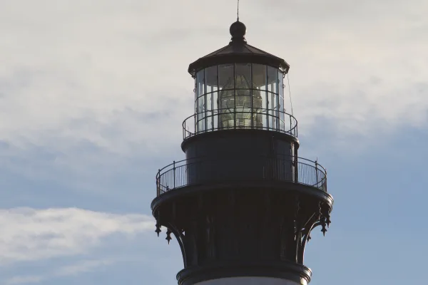
Cape Hatteras National Seashore
National Seashore
The sound of ocean waves, the starry night sky, or the calm of the salt marshes, you can experience it all. Shaped by the forces of water, wind, and storms these islands are ever changing. The plants,...
9 mi from route
~24 min detour
Free
near mile 13.7
Park Closure: Beach fires temporarily banned due to dry conditions and statewide burn ban
Park Closure: Beach safety closure in place from Buxton Village to near Ramp 43
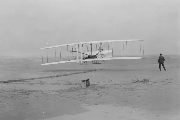
Wind, sand, and a dream of flight brought Wilbur and Orville Wright to Kitty Hawk, North Carolina where, after four years of scientific experimentation, they achieved the first successful airplane fli...
Park data from the National Park Service API. Alerts update every 2 hours.
More Details
What kind of drive is this?
This route is heavily highway-based, with 88% of the drive on major roads. The longest continuous stretch without needing to exit is 119.3 miles on I 85. You'll encounter a significant number of exits on I 85, requiring frequent attention as you navigate through various towns and merge points. The remaining 12% of the drive will be on US 64 and US 13, offering a change of pace from the interstate cruising.
88% highway — fuel and pacing are the main things to plan.
33 navigation steps total — most of the decisions cluster near the start and finish.
Longest single stretch: 119.3 mi on I 85.
How Hard Is This Drive?
9/10
This is a straightforward highway drive that stays mostly on I 85 and US 64. This route has several spots where lane changes, forks, or exits need your full attention. The trickiest moment comes around 70.4 miles in near US 64.
Driving Effort9/10
High effort - long or complex enough to need steady focus all day
Balances navigation complexity with total wheel time.
This is a demanding drive. With 22 significant decision points across 398.7 miles, you will need to stay alert - especially through interchange areas and urban stretches. Consider splitting it into segments if you are not comfortable with fast highway navigation.
Where does it get tricky?
The main spots that need attention: at 70.4 miles (US 64): Highway fork - watch signs carefully. Lane positioning matters here; at 224 miles: Highway fork - watch signs carefully; at 247 miles: Exit ramp - move to the correct lane early. Lane positioning matters here.
Charlotte is an ambitious and rapidly growing city in the southern part of the Piedmont of North Carolina. It is also developing its fledgling tourist industry; its central core is one of the most visitor-friendly districts in the Carolinas.
Charlotte's most popular attractions include the Carolina Panthers (NFL), the Charlotte Hornets (NBA), the NASCAR Hall of Fame, the Charlotte Ballet, Children's Theatre of Charlotte, Mint Museum, Harvey B. Gantt Center, Bechtler Museum of Modern Art, the Billy Graham Library, Levine Museum of the New South, Charlotte Museum of History, Carowinds amusement park, and the U.S. National Whitewater Center.
Top landmarks
•Carowinds — amusement park in North and South Carolina
•Dilworth — neighborhood in Charlotte, North Carolina, United States
•Elizabeth — neighborhood of Charlotte, North Carolina, United States
The longest stretch is about 119.3 miles on I 85. The full list of main roads is in the Roads section above.
Yes — a 2-day pace is more comfortable than one long haul. A sensible stopping point is after roughly 199 miles on day one.
Yes — we found about 29 rest areas or service plazas within a short detour of the route (from OpenStreetMap). See the Rest Stops tab under Nearby Places for locations and mile markers. Plan to stretch, use the bathroom, and top off fluids every 2–3 hours on longer drives.
It helps. This route has a higher-than-average number of complex decision points, which get harder in the dark. If the last hour of the trip is on surface roads or mountain grades, aim to arrive at Charlotte, NC before sunset when you can. Check the Trip Plan for departure windows that land you in daylight.
Only with planning. This is a long drive for kids — consider splitting it into two days rather than pushing through. Plan at least 2 meaningful breaks. There are 29 rest areas along the route for bathroom stops.
The main spots that need attention: at 70.4 miles (US 64): Highway fork - watch signs carefully. Lane positioning matters here; at 224 miles: Highway fork - watch signs carefully; at 247 miles: Exit ramp - move to the correct lane early. Lane positioning matters here.
Yes — Cape Hatteras National Seashore and Wright Brothers National Memorial. See the National Parks section for detour distances and tips on detours.
Not recommended in a single day. At 8.2 hours each way, a round trip means 16.4 hours of driving — that is an unsafe level of fatigue for most drivers. Plan at least one night at Charlotte, NC before the return drive.