Traveling from Brownsville to Cape Coral covers 150.9 miles and typically takes about 2 hours and 56 minutes. Because this is a relatively short distance, you can easily complete the entire trip in a single day without needing an overnight stay. Your route primarily utilizes I-75, transitioning into the Gratigny Parkway and Daniels Parkway as you approach your destination. With an estimated fuel cost of approximately $25, the drive is budget-friendly and straightforward. Whether you are heading south for a change of pace or visiting family, this highway-focused transit is designed for efficiency rather than sightseeing. It serves as a practical connection between these two Florida locations, keeping you on major thoroughfares for the vast majority of your journey.
Trip Pace
Same-day drive is realistic
A same-day return is realistic if you keep stops short.
Break Rhythm
1 planned break
A short stop every 2 to 3 hours is enough for this drive.
Midpoint
75.5 miles from Brownsville, FL
A natural place for your longest stop of the day
, about 1h 27m into the drive
.
Main Roads
Road
Distance
Duration
I 75
130 mi
2h 19m
Gratigny Parkway
5.1 mi
6m
Daniels Parkway
4.8 mi
8m
Northwest 32nd Avenue
4.1 mi
7m
College Parkway
3.2 mi
5m
Cape Coral Parkway East
1 mi
2m
South Cleveland Avenue
0.7 mi
1m
Cape Coral Bridge Road
0.7 mi
1m
Longest stretch:
I 75
— 130 mi, about 2h 19m
Turn-by-Turn Driving Directions
Step-by-step road directions between Brownsville, FL and Cape Coral, FL.
1
Start on this road
401 ft·32 sec·this road
2
Turn left
75 ft·11 sec
3
Turn left onto Northwest 53rd Street
460 ft·22 sec·Northwest 53rd Street
4
At end of road, turn right onto Northwest 29th Avenue
336 ft·22 sec·Northwest 29th Avenue
5
Turn left onto SR 944
0.4 mi·51 sec·Northwest 54th Street
6
Turn right onto Northwest 32nd Avenue
4.1 mi·7 min·Northwest 32nd Avenue
7
Turn left onto SR 924
0.3 mi·35 sec·Northwest 119th Street
8
Continue on SR 924
5.1 mi·6 min·Gratigny Parkway
Use the straight / slight right lanes.
9
Continue on I 75
16 mi·17 min·I 75
Use the straight / slight right lanes.
10
Keep slight left at fork onto I 75
114 mi·2 hr 2 min·I 75
Toward Alligator Alley, NaplesUse the slight left / straight lanes.
11
Take the exit
0.3 mi·43 sec
Exit 131Toward CR 876: Cape CoralUse the slight right lane.
12
Keep slight left at fork
524 ft·16 sec
Toward CR 876 West: Lee County Sports Complex, Florida SouthWestern State College, Cape CoralUse the left lane.
13
Turn left
116 ft·5 sec
Toward CR 876 West
14
Turn left onto CR 876
4.8 mi·8 min·Daniels Parkway
Use the left lane.
15
Turn right onto US 41
0.7 mi·1 min·South Cleveland Avenue
16
Turn left onto College Parkway
3.2 mi·5 min·College Parkway
Use the left lane.
17
Continue on Cape Coral Bridge Road
0.7 mi·1 min·Cape Coral Bridge Road
18
Continue on Cape Coral Parkway East
1.0 mi·2 min·Cape Coral Parkway East
19
Turn right
200 ft·14 sec
20
Arrive at destination
Trip Plan
Since the total trip duration is under three hours, you have plenty of flexibility regarding your departure time. Plan for at least one stop to break up the 150.9-mile journey, which will help keep you alert during the long I-75 segment. Given the heavy reliance on interstates, monitor traffic reports before you leave to avoid potential congestion on the main corridors. With a fuel budget of $25, filling up before you hit the longest 130-mile stretch is a smart way to ensure you aren't forced to stop at a pricier station mid-drive. Keep your focus on the parkway exits as you near Cape Coral, as these will be your primary access points into the city.
Morning Departure
Leave by 9 AM and you'll arrive before lunch.
Evening Departure
Even a 4 PM departure gets you there before dark in summer.
You can normally do this drive in one day.
Plan roughly 1 meaningful break for fuel, food, and rest.
The halfway point lands around 75.5 miles from Brownsville, FL, or about 1h 27m into the drive.
The longest continuous stretch on this route runs about 130 miles.
This is a comfortable same-day trip.
Departure
Before you leave
Start with fuel, water, and navigation already sorted so the first hour feels easy.
First stop
Around 33 miles or 41m in
Use this first pause for coffee, a restroom break, and a quick traffic check ahead.
Halfway reset
Around 75.5 miles or 1h 27m in
This is the best place for your longest stop, a real meal, and a full fuel check.
Final approach
Final hour starts around 2h 19m
Traffic, exits, and arrival timing usually matter more near Cape Coral, FL than in the middle of the route.
Before You Leave
+
Open the route before leaving Brownsville, FL so your first major turns are already loaded.
+
Leave with enough water and a charging cable within reach, not packed away.
+
Check your fuel range against the first long segment, especially if you are starting outside city service areas.
Day 1
Settle into the route from Brownsville, FL
This is one driving day of about 150.9 miles and 2h 56m.
Your first comfortable stop window is around 33 miles from Brownsville, FL.
This route can stay practical as a one-day drive if traffic stays reasonable.
Plan about 1 real break rather than only quick fuel stops.
The longest stretch is on I 75 for about 130 miles.
Where to Stop
Rest stops, refuel points, and overnight suggestions along this route.
Place data sourced from public business listings. Hours and availability may vary.
Heads-up: tricky spots
5 of 12
5 decision points cluster between mile 0.1 and 140.4 — GPS handles the exact turns, but know they're coming. Your lane choice matters more than the turn itself.
5
0.1 mi into trip|~0m in|Northwest 53rd Street
Turn left onto Northwest 53rd Street
Navigation decision point
6
0.2 mi into trip|~1m in|Northwest 29th Avenue
At end of road, turn right onto Northwest 29th Avenue
Complex interchange - multiple decisions in a short stretch
8
26 mi into trip|~34m in|I 75
Keep slight left at fork onto I 75 toward Alligator Alley, Naples
Highway fork - watch signs carefully. Lane positioning matters here. Multiple destination signs - pick the right one
Use the slight left / straight lanes.
Toward Alligator Alley, Naples
7
140 mi into trip|~2h 36m in
Take the exit toward CR 876: Cape Coral
Exit ramp - move to the correct lane early. Lane positioning matters here
Use the slight right lane.
Exit 131
Toward CR 876: Cape Coral
8
140.4 mi into trip|~2h 37m in
Keep slight left at fork toward CR 876 West: Lee County Sports Complex, Florida SouthWestern State College, Cape Coral
Highway fork - watch signs carefully. Lane positioning matters here. Multiple destination signs - pick the right one
Use the left lane.
Toward CR 876 West: Lee County Sports Complex,...
Fuel & Cost
Regular Gas
$24.02 one way
$48.04 round trip
$4.04/gal25.4 MPG avg53 kg CO2
Fuel Type
$/gal
One Way
Round Trip
midgrade
$4.40
$26.13
$52.26
premium
$4.72
$28.06
$56.12
diesel
$5.61
$33.32
$66.63
No toll roads detected on this route.
Estimated Trip Cost (one way, 1 person)
Fuel
$24
Meals
$25–$50
Total
$49–$74
Rough estimate based on US averages. Hotel $80–$140/night, meals $25–$50/day.
Estimated CO2 emission: 52.8 kg one way.
Prices: EIA weekly data, 2026-04-13.
Driving Electric?
About $16 in charging
· 0 stops
· 66% less CO2
Vehicle Type
kWh
Stops
DC Fast
Home Charge
Average EV
45.3
0
$15.84
$7.24
Efficient EV
37.7
0
$13.20
$6.04
EV Truck/SUV
60.4
0
$21.13
$9.66
Gas CO2
53 kg
EV CO2
18 kg (66% less)
This trip is well within single-charge range for most EVs. No charging stops needed if you start fully charged.
DC fast charging avg $0.35/kWh. Home charging avg $0.16/kWh. US grid CO2: 0.39 kg/kWh.
Travel Intel
Current conditions at both ends of the drive.
Forecast as of Apr 15, 2026
Origin
Brownsville, FL
Late night
in Brownsville on Sunday
Local time
12:27 AM
EDT
Current temp
69°F
Unavailable
Live forecast
Destination
Cape Coral, FL
Late night
in Cape Coral on Sunday
Local time
12:27 AM
EDT
Current temp
66°F
Unavailable
Live forecast
Seasonal Notes
Summer travel usually means heavier construction, hotter rest stops, and busier weekend traffic around major cities.
Winter travel shortens daylight, so a route that looks manageable on paper can feel much longer after dark.
Holiday weekends tend to make both departure and arrival windows slower than the raw route time suggests.
Time zone
Same local time
Origin and destination are on the same clock, so arrival timing is easier to judge at a glance.
Temperature spread
3 degrees cooler at arrival
A meaningful temperature swing is a good cue to rethink layers, water, and how soon you want to arrive.
Road read
2h 56m on the road
Use the two city cards together: check the sky where you start, then compare it with the local time and temperature at arrival.
Weather data from the National Weather Service. Conditions may change; check closer to your travel date.
National Parks Near This Route
Worth a detour if your schedule allows.
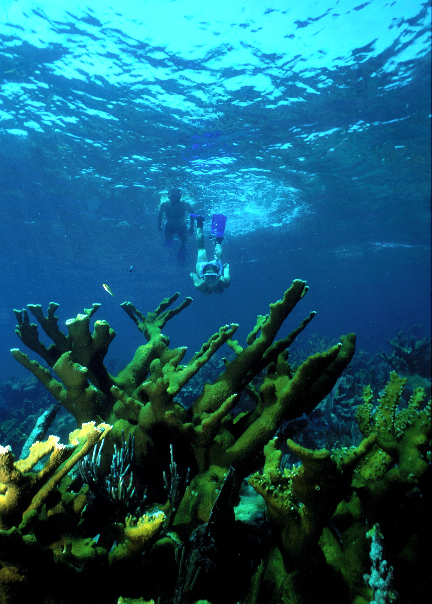
Biscayne National Park
National Park
Within sight of Miami, yet worlds away, Biscayne protects a rare combination of aquamarine waters, emerald islands, and fish-bejeweled coral reefs. Evidence of 10,000 years of human history is here to...
Park data from the National Park Service API. Alerts update every 2 hours.
More Details
What kind of drive is this?
Expect a very consistent experience on this drive, as it is composed of 95% highway travel. You will spend the bulk of your time on I-75, which features a long, uninterrupted stretch of 130 miles. This highway-focused profile means you should prepare for a steady, monotonous pace behind the wheel rather than technical turns or local backroads. As you move away from the Brownsville area and approach the Cape Coral region, the transition onto the Gratigny and Daniels Parkways indicates you are nearing your arrival. The road personality is functional and fast, ideal for drivers who prioritize getting from point A to point B without unnecessary deviations.
95% highway — fuel and pacing are the main things to plan.
20 navigation steps total — most of the decisions cluster near the start and finish.
Longest single stretch: 130 mi on I 75.
How Hard Is This Drive?
6/10
This is a straightforward highway drive that stays mostly on I 75 and Gratigny Parkway. You will hit about 12 points where you need to pay attention to lane position or signs. The trickiest moment comes around 0.1 miles in near Northwest 53rd Street.
Driving Effort6/10
Moderate - straightforward overall, but long enough or busy enough to require pacing
Balances navigation complexity with total wheel time.
This drive requires moderate attention. Across 150.9 miles you will encounter 12 spots where lane choice or exit timing matters. Not difficult for experienced highway drivers, but worth previewing the tricky sections before you go.
Where does it get tricky?
The main spots that need attention: at 0.1 miles (Northwest 53rd Street): Navigation decision point; at 0.2 miles (Northwest 29th Avenue): Complex interchange - multiple decisions in a short stretch; at 26 miles (I 75): Highway fork - watch signs carefully. Lane positioning matters here. Multiple destination signs - pick the right one.
Towns Mentioned on Route Signs
Based on OSRM destination-sign hints, not a full list of every settlement the road passes.
Between Brownsville, FL and Cape Coral, FL, road signs point toward Alligator Alley, Naples, Cr 876: Cape Coral, Cr 876 West: Lee County Sports Complex, Florida Southwestern State College and Cr 876 West.
Cape Coral is a city in Southwest Florida. Visitors are drawn by its beaches, nature trails and sea kayaking opportunities on Black Island in Lovers Key State Park.
Doable as a same-day drive at 2h 56m. Total distance: 150.9 miles.
Family Friendly
Moderate complexity with 1 natural rest stops along the way.
Solo Traveler
2h 56m drive, comfortable solo distance.
First-Time Driver
Mostly highway driving (95%). Some complex stretches to watch for.
Frequently Asked Questions
The longest stretch is about 130 miles on I 75. The full list of main roads is in the Roads section above.
It helps. This route has a higher-than-average number of complex decision points, which get harder in the dark. If the last hour of the trip is on surface roads or mountain grades, aim to arrive at Cape Coral, FL before sunset when you can. Check the Trip Plan for departure windows that land you in daylight.
Only with planning. This is a long drive for kids — consider splitting it into two days rather than pushing through. Plan at least 1 meaningful breaks. Dedicated rest areas are limited, so plan gas or food stops as your bathroom breaks.
The main spots that need attention: at 0.1 miles (Northwest 53rd Street): Navigation decision point; at 0.2 miles (Northwest 29th Avenue): Complex interchange - multiple decisions in a short stretch; at 26 miles (I 75): Highway fork - watch signs carefully. Lane positioning matters here. Multiple destination signs - pick the right one.
Yes — Biscayne National Park. See the National Parks section for detour distances and tips on detours.
Yes. A round trip is manageable in a single day if you plan a break at Cape Coral, FL before heading back.