Brent, FL to Sawgrass, FL is 377.4 miles and takes about 6h 59m via I 10 and I 95, with a fuel budget near $60 and enough daylight to finish in a day. This trip stays within Florida, taking you across the state on a predominantly highway route. Expect a straightforward drive with minimal complexity, making it a solid option for a single-day excursion. The majority of your travel will be on well-maintained interstates, so plan for consistent speeds and clear navigation.
Trip Pace
Same-day drive is realistic
A same-day return is possible, but it will make for a full day on the road.
Break Rhythm
1 planned break
Plan on a short reset every 3 to 4 hours to stay fresh behind the wheel.
Midpoint
188.7 miles from Brent, FL
A natural place for your longest stop of the day
, about 3h 25m into the drive
.
Main Roads
Road
Distance
Duration
I 10
348.4 mi
6h 15m
Butler Boulevard
12.1 mi
14m
I 95
6.6 mi
8m
3rd Street South
3.6 mi
6m
Reubin O'Donovan Askew Parkway
0.9 mi
1m
Preston Trail East
0.6 mi
2m
Country Club Boulevard
0.5 mi
1m
Brent Lane
0.4 mi
1m
Longest stretch:
I 10
— 348.4 mi, about 6h 15m
Traffic on I-10
Hour-of-day weekday pattern from 68 FHWA count stations on your route.
Peak
3 PM
~1,165 veh/hr typical
· worst 1,621
Quietest
2 AM
~145 veh/hr
Peak-to-quiet ratio
8×
busier at peak than in the quiet hours
12a6anoon6p11p
Averaged across 52 weeks of 2023 FHWA Travel Monitoring Analysis System data. Weekday hours only (Mon–Fri).
Turn-by-Turn Driving Directions
Step-by-step road directions between Brent, FL and Sawgrass, FL.
1
Start on East Brent Lane
0.1 mi·26 sec·East Brent Lane
2
Continue on FL 296
0.4 mi·1 min·Brent Lane
3
Turn left
0.3 mi·36 sec
4
Keep slight left at fork
0.5 mi·54 sec
Toward I 110 NorthUse the straight / slight right lanes.
5
Merge onto I 110
0.9 mi·1 min·Reubin O'Donovan Askew Parkway
6
Keep slight right at fork
0.3 mi·28 sec
Exit 6Toward I 10 East, FL 291: Tallahassee, Davis HighwayUse the straight / slight right lanes.
7
Keep slight left at fork
0.7 mi·1 min
Toward I 10 East: Tallahassee
8
Merge onto I 10
348 mi·6 hr 15 min·I 10
Use the straight / slight right lanes.
9
Take the exit
0.4 mi·33 sec
Toward I 95 South: Jacksonville Beaches, Daytona Beach
10
Keep slight right at fork
0.6 mi·1 min
Toward I 95 South: Jacksonville Beaches, Daytona BeachUse the slight left / slight right lanes.
11
Merge onto I 95
6.6 mi·8 min·I 95
Use the straight / slight right lanes.
12
Take the exit
0.7 mi·1 min
Exit 344Toward FL 202: Butler Boulevard, Jacksonville BeachesUse the straight / slight right lanes.
13
Keep slight left at fork
365 ft·13 sec
Toward FL 202 EastUse the left lane.
14
Turn straight onto FL 202
0.2 mi·15 sec·J. Turner Butler Boulevard
15
Continue on FL 202
12 mi·14 min·Butler Boulevard
Use the straight / slight right lanes.
16
Keep slight right at fork
0.4 mi·45 sec
Toward SR A1A South: Ponte Vedra, Saint AugustineUse the slight right lane.
17
Turn straight onto SR A1A
3.6 mi·6 min·3rd Street South
18
Turn left onto Country Club Boulevard
0.5 mi·1 min·Country Club Boulevard
19
Continue on Preston Trail East
0.6 mi·2 min·Preston Trail East
20
Turn right onto Deer Run Drive South
41 ft·1 sec·Deer Run Drive South
21
Arrive at destination
Deer Run Drive South
Trip Plan
Given the 6h 59m duration, leaving Brent, FL in the morning will allow you to reach Sawgrass, FL with plenty of daylight to spare. With only one recommended stop, you can be quite flexible with your timing. Keep an eye on your fuel as you approach the 348.4-mile stretch on I 10, as services might be less frequent in certain sections. Planning your fuel stops around major exits on I 10 and I 95 will be key to a smooth drive.
Morning Departure
Start early — leave by 6-7 AM to arrive at a reasonable hour.
Evening Departure
This is a long drive — plan for a morning departure or consider splitting it into two days.
You can normally do this drive in one day.
Plan roughly 1 meaningful break for fuel, food, and rest.
The halfway point lands around 188.7 miles from Brent, FL, or about 3h 25m into the drive.
The longest continuous stretch on this route runs about 348.4 miles.
This is a comfortable same-day trip.
Departure
Before you leave
Start with fuel, water, and navigation already sorted so the first hour feels easy.
First stop
Around 83 miles or 1h 31m in
Use this first pause for coffee, a restroom break, and a quick traffic check ahead.
Halfway reset
Around 188.7 miles or 3h 25m in
This is the best place for your longest stop, a real meal, and a full fuel check.
Final approach
Final hour starts around 5h 44m
Traffic, exits, and arrival timing usually matter more near Sawgrass, FL than in the middle of the route.
Before You Leave
+
Open the route before leaving Brent, FL so your first major turns are already loaded.
+
Leave with enough water and a charging cable within reach, not packed away.
+
Check your fuel range against the first long segment, especially if you are starting outside city service areas.
Day 1
Settle into the route from Brent, FL
This is one driving day of about 377.4 miles and 6h 59m.
Your first comfortable stop window is around 83 miles from Brent, FL.
This route can stay practical as a one-day drive if traffic stays reasonable.
Plan about 1 real break rather than only quick fuel stops.
The longest stretch is on I 10 for about 348.4 miles.
Where to Stop
Rest stops, refuel points, and overnight suggestions along this route.
Place data sourced from public business listings. Hours and availability may vary.
Heads-up: tricky spots
5 of 13
5 decision points cluster between mile 0.9 and 372.3 — GPS handles the exact turns, but know they're coming. Your lane choice matters more than the turn itself.
7
0.9 mi into trip|~2m in
Keep slight left at fork toward I 110 North
Highway fork - watch signs carefully. Lane positioning matters here
Use the straight / slight right lanes.
Toward I 110 North
9
2.3 mi into trip|~4m in
Keep slight right at fork toward I 10 East, FL 291: Tallahassee, Davis Highway
Highway fork - watch signs carefully. Lane positioning matters here. Multiple destination signs - pick the right one
Use the straight / slight right lanes.
Exit 6
Toward I 10 East, FL 291: Tallahassee, Davis Hi...
8
352.1 mi into trip|~6h 21m in
Keep slight right at fork toward I 95 South: Jacksonville Beaches, Daytona Beach
Highway fork - watch signs carefully. Lane positioning matters here. Multiple destination signs - pick the right one
Use the slight left / slight right lanes.
Toward I 95 South: Jacksonville Beaches, Dayton...
8
359.3 mi into trip|~6h 30m in
Take the exit toward FL 202: Butler Boulevard, Jacksonville Beaches
Exit ramp - move to the correct lane early. Lane positioning matters here. Multiple destination signs - pick the right one
Use the straight / slight right lanes.
Exit 344
Toward FL 202: Butler Boulevard, Jacksonville B...
8
372.3 mi into trip|~6h 47m in
Keep slight right at fork toward SR A1A South: Ponte Vedra, Saint Augustine
Highway fork - watch signs carefully. Lane positioning matters here. Multiple destination signs - pick the right one
Use the slight right lane.
Toward SR A1A South: Ponte Vedra, Saint Augusti...
Fuel & Cost
Regular Gas
$57.13 one way
$114.26 round trip
$3.85/gal25.4 MPG avg132 kg CO2
Fuel Type
$/gal
One Way
Round Trip
midgrade
$4.22
$62.69
$125.37
premium
$4.55
$67.61
$135.21
diesel
$4.80
$71.26
$142.52
No toll roads detected on this route.
Estimated Trip Cost (one way, 1 person)
Fuel
$57
Meals
$25–$50
Total
$82–$107
Rough estimate based on US averages. Hotel $80–$140/night, meals $25–$50/day.
Estimated CO2 emission: 132 kg one way.
Prices: EIA weekly data, 2026-07-13.
Driving Electric?
About $40 in charging
· 1 stop
· 67% less CO2
Vehicle Type
kWh
Stops
DC Fast
Home Charge
Average EV
113.2
1
$39.63
$18.12
Efficient EV
94.4
1
$33.02
$15.10
EV Truck/SUV
151
1
$52.84
$24.15
Gas CO2
132 kg
EV CO2
44 kg (67% less)
Plan for 1 charging stop. A 30-minute DC fast charge mid-route should be enough to complete the trip comfortably.
DC fast charging avg $0.35/kWh. Home charging avg $0.16/kWh. US grid CO2: 0.39 kg/kWh.
Travel Intel
Current conditions at both ends of the drive.
Forecast as of Jul 17, 2026
Origin
Brent, FL
Morning
in Brent on Sunday
Local time
10:27 AM
CDT
Current temp
77°F
Mostly Clear
W 5 mph3% chanceLive forecast
Rip Current Statement
Rip Current Statement issued July 16 at 11:29AM EDT until July 17 at 4:00AM EDT by NWS Melbourne FL
Destination
Sawgrass, FL
Morning
in Sawgrass on Sunday
Local time
11:27 AM
EDT
Current temp
78°F
Mostly Clear
W 6 mph0% chanceLive forecast
Rip Current Statement
Rip Current Statement issued July 16 at 11:29AM EDT until July 17 at 4:00AM EDT by NWS Melbourne FL
Seasonal Notes
Summer travel usually means heavier construction, hotter rest stops, and busier weekend traffic around major cities.
Winter travel shortens daylight, so a route that looks manageable on paper can feel much longer after dark.
Holiday weekends tend to make both departure and arrival windows slower than the raw route time suggests.
Time zone
1 hour later
The destination clock does not match departure time, so double-check hotel check-in windows and late arrival plans.
Temperature spread
1 degrees warmer at arrival
A meaningful temperature swing is a good cue to rethink layers, water, and how soon you want to arrive.
Road read
6h 59m on the road
Start early — leave by 6-7 AM to arrive at a reasonable hour.
Weather data from the National Weather Service. Conditions may change; check closer to your travel date.
National Parks Near This Route
Worth a detour if your schedule allows.
Gulf Islands National Seashore
National Seashore
Millions of visitors are drawn to the Gulf of America for Gulf Islands National Seashore's emerald coast waters, magnificent white beaches, fertile marshes and historical landscapes. Come explore with...
10 mi from route
~26 min detour
$25
Park Closure: Fort Pickens Campground Restroom A Loop Closure
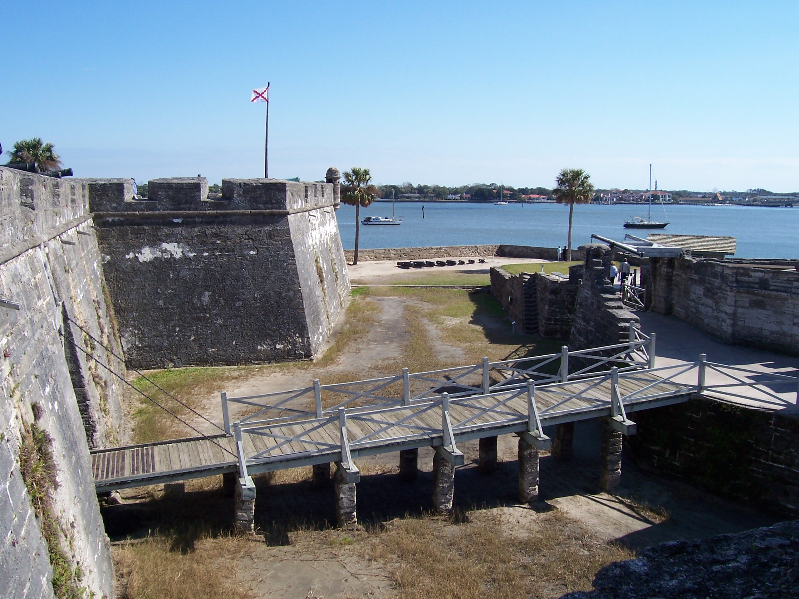
Built by the Spanish in St. Augustine to defend Florida and the Atlantic trade route, Castillo de San Marcos National Monument preserves the oldest masonry fortification in the continental United Stat...
21 mi from route
~52 min detour
$15
near mile 377.4
Park data from the National Park Service API. Alerts update every 2 hours.
More Details
What kind of drive is this?
This drive is 94% highway, meaning you'll spend most of your time on high-speed roads like I 10 and I 95. The longest stretch without a significant change in road type is a substantial 348.4 miles on I 10. You'll experience the feel of long-distance highway cruising for the vast majority of this trip. Expect frequent exits and entrances as you navigate the interstate system.
94% highway — fuel and pacing are the main things to plan.
21 navigation steps total — most of the decisions cluster near the start and finish.
Longest single stretch: 348.4 mi on I 10.
How Hard Is This Drive?
8/10
This is a straightforward highway drive that stays mostly on I 10 and Butler Boulevard. This route has several spots where lane changes, forks, or exits need your full attention. The trickiest moment comes around 0.9 miles in.
Driving Effort8/10
Demanding - plan breaks and stay ahead of the key maneuvers
Balances navigation complexity with total wheel time.
This is a demanding drive. With 13 significant decision points across 377.4 miles, you will need to stay alert - especially through interchange areas and urban stretches. Consider splitting it into segments if you are not comfortable with fast highway navigation.
Where does it get tricky?
The main spots that need attention: at 0.9 miles: Highway fork - watch signs carefully. Lane positioning matters here; at 2.3 miles: Highway fork - watch signs carefully. Lane positioning matters here. Multiple destination signs - pick the right one; at 352.1 miles: Highway fork - watch signs carefully. Lane positioning matters here. Multiple destination signs - pick the right one.
Elevation Profile
Mostly flat terrain
293 ft6 ft
Total Climb
397 ft
Total Descent
489 ft
Highest Point
293 ft
~161.7 mi in
Elevation Range
287 ft
Towns Mentioned on Route Signs
Based on OSRM destination-sign hints, not a full list of every settlement the road passes.
On the drive from Brent, FL to Sawgrass, FL, road signs begin pointing toward Daytona Beach along the way.
Doable as a same-day drive at 6h 59m. Total distance: 377.4 miles.
Family Friendly
Moderate complexity with 1 natural rest stops along the way.
Solo Traveler
6h 59m drive, plan rest stops for pacing.
Frequently Asked Questions
The longest stretch is about 348.4 miles on I 10. The full list of main roads is in the Roads section above.
Yes — we found about 31 rest areas or service plazas within a short detour of the route (from OpenStreetMap). See the Rest Stops tab under Nearby Places for locations and mile markers. Plan to stretch, use the bathroom, and top off fluids every 2–3 hours on longer drives.
It helps. This route has a higher-than-average number of complex decision points, which get harder in the dark. If the last hour of the trip is on surface roads or mountain grades, aim to arrive at Sawgrass, FL before sunset when you can. Check the Trip Plan for departure windows that land you in daylight.
Only with planning. This is a long drive for kids — consider splitting it into two days rather than pushing through. Plan at least 1 meaningful breaks. There are 31 rest areas along the route for bathroom stops.
The main spots that need attention: at 0.9 miles: Highway fork - watch signs carefully. Lane positioning matters here; at 2.3 miles: Highway fork - watch signs carefully. Lane positioning matters here. Multiple destination signs - pick the right one; at 352.1 miles: Highway fork - watch signs carefully. Lane positioning matters here. Multiple destination signs - pick the right one.
Yes — Gulf Islands National Seashore and Castillo de San Marcos National Monument. See the National Parks section for detour distances and tips on detours.
Not recommended in a single day. At 7.0 hours each way, a round trip means 14.0 hours of driving — that is an unsafe level of fatigue for most drivers. Plan at least one night at Sawgrass, FL before the return drive.