Traveling from Belleair to Pembroke Pines covers 264.9 miles across the Florida landscape. Expect about 5 hours and 2 minutes of driving time, making this a very manageable single-day trip. You will spend the vast majority of your journey on major interstates, specifically I-275 and I-75, providing a direct path between these two points. Budgeting approximately $44 for fuel should keep you covered for the entire trek. Since you are moving from the Gulf Coast region down toward the South Florida area, you can easily complete this drive in one go without needing an overnight stop. It is a straightforward, highway-focused route that prioritizes efficiency over exploration.
Trip Pace
Same-day drive is realistic
A same-day return is possible, but it will make for a full day on the road.
Break Rhythm
1 planned break
Plan on a short reset every 3 to 4 hours to stay fresh behind the wheel.
Midpoint
132.5 miles from Belleair, FL
A natural place for your longest stop of the day
, about 2h 35m into the drive
.
Main Roads
Road
Distance
Duration
I 75
209.3 mi
3h 44m
Sunshine Skyway Bridge
13.4 mi
15m
I 275
11.2 mi
14m
Port Everglades Expressway
9 mi
10m
US Highway 19 North
6.4 mi
9m
Florida's Turnpike
4.2 mi
4m
East Bay Drive
3.5 mi
6m
54th Avenue North
0.8 mi
1m
Longest stretch:
I 75
— 209.3 mi, about 3h 44m
Turn-by-Turn Driving Directions
Step-by-step road directions between Belleair, FL and Pembroke Pines, FL.
1
Start on Gardenia Street
135 ft·8 sec·Gardenia Street
2
Turn right onto Indian Rocks Road
281 ft·7 sec·Indian Rocks Road
3
Enter roundabout onto Indian Rocks Road
73 ft·1 sec·Indian Rocks Road
4
Continue on Indian Rocks Road
0.3 mi·44 sec·Indian Rocks Road
5
Turn left onto Poinsettia Road
0.6 mi·1 min·Poinsettia Road
6
Continue on Rosery Road Northwest
0.3 mi·43 sec·Rosery Road Northwest
7
Turn right onto Clearwater Largo Road North
0.8 mi·1 min·Clearwater Largo Road North
8
Turn left onto CR 416
0.5 mi·51 sec·West Bay Drive
Use the left lane.
9
Continue on FL 686
3.5 mi·6 min·East Bay Drive
Use the left lane.
10
Turn right onto US 19 Southbound Frontage Road
430 ft·8 sec·US 19 Southbound Frontage Road
11
Take the ramp
0.3 mi·39 sec
Toward US 19 South
12
Merge onto US 19
2.1 mi·2 min·US Highway 19 North
Use the straight / slight right lanes.
13
Keep slight left at fork onto US 19
4.4 mi·6 min·US Highway 19 North
Use the straight / slight right lanes.
14
Continue on US 19
0.6 mi·1 min·34th Street North
15
Turn left onto 54th Avenue North
0.8 mi·1 min·54th Avenue North
Use the left lane.
16
Take the ramp
0.2 mi·31 sec
Toward I 275 SouthUse the right lane.
17
Merge onto I 275
10 mi·11 min·I 275
Use the straight / slight right lanes.
18
Keep slight left at fork
0.3 mi·17 sec
19
Merge onto I 275; US 19
13 mi·15 min·Sunshine Skyway Bridge
Use the straight / slight right lanes.
20
Keep slight left at fork onto I 275
1.1 mi·2 min·I 275
Toward I 75 South: Naples
21
Merge onto I 75
28 mi·30 min·I 75
Use the straight / slight right lanes.
22
Keep slight left at fork onto I 75
181 mi·3 hr 14 min·I 75
Use the straight / slight right lanes.
23
Keep slight right at fork onto I 595
9.0 mi·10 min·Port Everglades Expressway
Exit 19Toward SR 869 Toll North, I 595 East: Coral Springs, Fort LauderdaleUse the straight / slight right lanes.
24
Take the exit
0.1 mi·18 sec
Exit 8; 9A-BToward US 441: Orlando, Miami, Florida's TurnpikeUse the slight right lane.
25
Turn straight onto SR 84
0.4 mi·37 sec·SR 84
Toward SR 84 East, I 595 East, US 441: Florida's Turnpike, North Orlando, South Miami
26
Take the ramp
0.4 mi·46 sec
Exit 8Toward Florida's Turnpike, Miami South, Orlando NorthUse the straight / right lanes.
27
Keep slight left at fork
0.4 mi·56 sec
Toward Miami, Florida's TurnpikeUse the straight / slight right lanes.
28
Keep slight left at fork
0.3 mi·33 sec
Toward Miami, Florida's Turnpike South
29
Merge onto Florida's Turnpike
4.2 mi·4 min·Florida's Turnpike
30
Take the exit
0.4 mi·43 sec
Exit 49BToward SR 820 West: Pines BoulevardUse the straight / slight right lanes.
31
Merge onto SR 820
0.2 mi·36 sec·Hollywood Boulevard
32
Turn left onto Southwest 64th Way
0.5 mi·1 min·Southwest 64th Way
Use the left lane.
33
Continue on Southwest 8th Street
0.2 mi·56 sec·Southwest 8th Street
34
Arrive at destination
Southwest 8th Street
Trip Plan
To keep your 5-hour drive comfortable, plan for at least one dedicated stop to break up the 209.3-mile stretch on I-75. Aim to depart early in the morning to avoid peak traffic congestion, which can significantly impact your travel time on these busy Florida corridors. Since you are spending roughly $44 on fuel, check your tire pressure before leaving Belleair to ensure you get the best possible mileage on the highway. Given the 91% highway share, keep your cruise control ready and stay alert for changing traffic patterns near major interchanges. Having the flexibility of a single-day trip means you can easily adjust your departure time to suit your personal schedule while still arriving in Pembroke Pines by the afternoon.
Morning Departure
An early start around 7-8 AM gets you there with plenty of daylight left.
Evening Departure
A late afternoon start means arriving after dark. Morning is better.
You can normally do this drive in one day.
Plan roughly 1 meaningful break for fuel, food, and rest.
The halfway point lands around 132.5 miles from Belleair, FL, or about 2h 35m into the drive.
The longest continuous stretch on this route runs about 209.3 miles.
This is a comfortable same-day trip.
Departure
Before you leave
Start with fuel, water, and navigation already sorted so the first hour feels easy.
First stop
Around 58 miles or 1h 15m in
Use this first pause for coffee, a restroom break, and a quick traffic check ahead.
Halfway reset
Around 132.5 miles or 2h 35m in
This is the best place for your longest stop, a real meal, and a full fuel check.
Final approach
Final hour starts around 4h 5m
Traffic, exits, and arrival timing usually matter more near Pembroke Pines, FL than in the middle of the route.
Before You Leave
+
Open the route before leaving Belleair, FL so your first major turns are already loaded.
+
Leave with enough water and a charging cable within reach, not packed away.
+
Check your fuel range against the first long segment, especially if you are starting outside city service areas.
Day 1
Settle into the route from Belleair, FL
This is one driving day of about 264.9 miles and 5h 2m.
Your first comfortable stop window is around 58 miles from Belleair, FL.
This route can stay practical as a one-day drive if traffic stays reasonable.
Plan about 1 real break rather than only quick fuel stops.
The longest stretch is on I 75 for about 209.3 miles.
Where to Stop
Rest stops, refuel points, and overnight suggestions along this route.
Place data sourced from public business listings. Hours and availability may vary.
Heads-up: tricky spots
5 of 28
5 decision points cluster between mile 248.7 and 263.6 — GPS handles the exact turns, but know they're coming. Your lane choice matters more than the turn itself.
9
248.7 mi into trip|~4h 39m in|I 595 / Port Everglades Expressway
Keep slight right at fork onto I 595 / Port Everglades Expressway toward SR 869 Toll North, I 595 East: Coral Springs, Fort Lauderdale
Highway fork - watch signs carefully. Lane positioning matters here. Multiple destination signs - pick the right one
Use the straight / slight right lanes.
Exit 19
Toward SR 869 Toll North, I 595 East: Coral Spr...
8
257.7 mi into trip|~4h 50m in
Take the exit toward US 441: Orlando, Miami, Florida's Turnpike
Exit ramp - move to the correct lane early. Lane positioning matters here. Multiple destination signs - pick the right one
Use the slight right lane.
Exit 8; 9A-B
Toward US 441: Orlando, Miami, Florida's Turnpi...
7
258.3 mi into trip|~4h 50m in
Take the ramp toward Florida's Turnpike, Miami South, Orlando North
Lane positioning matters here. Multiple destination signs - pick the right one
Use the straight / right lanes.
Exit 8
Toward Florida's Turnpike, Miami South, Orlando...
8
258.6 mi into trip|~4h 51m in
Keep slight left at fork toward Miami, Florida's Turnpike
Highway fork - watch signs carefully. Lane positioning matters here. Multiple destination signs - pick the right one
Use the straight / slight right lanes.
Toward Miami, Florida's Turnpike
7
263.6 mi into trip|~4h 58m in
Take the exit toward SR 820 West: Pines Boulevard
Exit ramp - move to the correct lane early. Lane positioning matters here
Use the straight / slight right lanes.
Exit 49B
Toward SR 820 West: Pines Boulevard
Fuel & Cost
Regular Gas
$42.16 one way
$84.33 round trip
$4.04/gal25.4 MPG avg93 kg CO2
Fuel Type
$/gal
One Way
Round Trip
midgrade
$4.40
$45.87
$91.73
premium
$4.72
$49.26
$98.51
diesel
$5.61
$58.49
$116.97
Estimated Tolls: $1.24
Sunshine Skyway Bridge
(13.4 mi)$0.94
Florida's Turnpike
(4.2 mi)$0.30
Toll estimates based on average 2024-2025 rates. EZ-Pass/SunPass discounts may lower the actual cost.
Estimated Trip Cost (one way, 1 person)
Fuel
$42
Tolls
$1
Meals
$25–$50
Total
$68–$93
Rough estimate based on US averages. Hotel $80–$140/night, meals $25–$50/day.
Estimated CO2 emission: 92.7 kg one way.
Prices: EIA weekly data, 2026-04-13.
Driving Electric?
About $28 in charging
· 0 stops
· 67% less CO2
Vehicle Type
kWh
Stops
DC Fast
Home Charge
Average EV
79.5
0
$27.81
$12.72
Efficient EV
66.2
0
$23.18
$10.60
EV Truck/SUV
106
1
$37.09
$16.95
Gas CO2
93 kg
EV CO2
31 kg (67% less)
Plan for 0 charging stops, roughly every 270 miles. Allow 25-40 minutes per stop at a DC fast charger.
DC fast charging avg $0.35/kWh. Home charging avg $0.16/kWh. US grid CO2: 0.39 kg/kWh.
Travel Intel
Current conditions at both ends of the drive.
Forecast as of Apr 13, 2026
Origin
Belleair, FL
Night
in Belleair on Saturday
Local time
10:54 PM
EDT
Current temp
64°F
Mostly Clear
E 10 mph0% chanceLive forecast
Rip Current Statement
Rip Current Statement issued April 12 at 3:58PM EDT until April 13 at 8:00PM EDT by NWS Miami FL
Rip Current Statement
Rip Current Statement issued April 12 at 2:27PM EDT until April 13 at 5:00AM EDT by NWS Jacksonville FL
Destination
Pembroke Pines, FL
Night
in Pembroke Pines on Saturday
Local time
10:54 PM
EDT
Current temp
70°F
Partly Cloudy
NE 13 to 17 mph0% chanceLive forecast
Rip Current Statement
Rip Current Statement issued April 12 at 3:58PM EDT until April 13 at 8:00PM EDT by NWS Miami FL
Rip Current Statement
Rip Current Statement issued April 12 at 2:27PM EDT until April 13 at 5:00AM EDT by NWS Jacksonville FL
Seasonal Notes
Summer travel usually means heavier construction, hotter rest stops, and busier weekend traffic around major cities.
Winter travel shortens daylight, so a route that looks manageable on paper can feel much longer after dark.
Holiday weekends tend to make both departure and arrival windows slower than the raw route time suggests.
Time zone
Same local time
Origin and destination are on the same clock, so arrival timing is easier to judge at a glance.
Temperature spread
6 degrees warmer at arrival
A meaningful temperature swing is a good cue to rethink layers, water, and how soon you want to arrive.
Road read
5h 2m on the road
An early start around 7-8 AM gets you there with plenty of daylight left.
Weather data from the National Weather Service. Conditions may change; check closer to your travel date.
National Parks Near This Route
Worth a detour if your schedule allows.
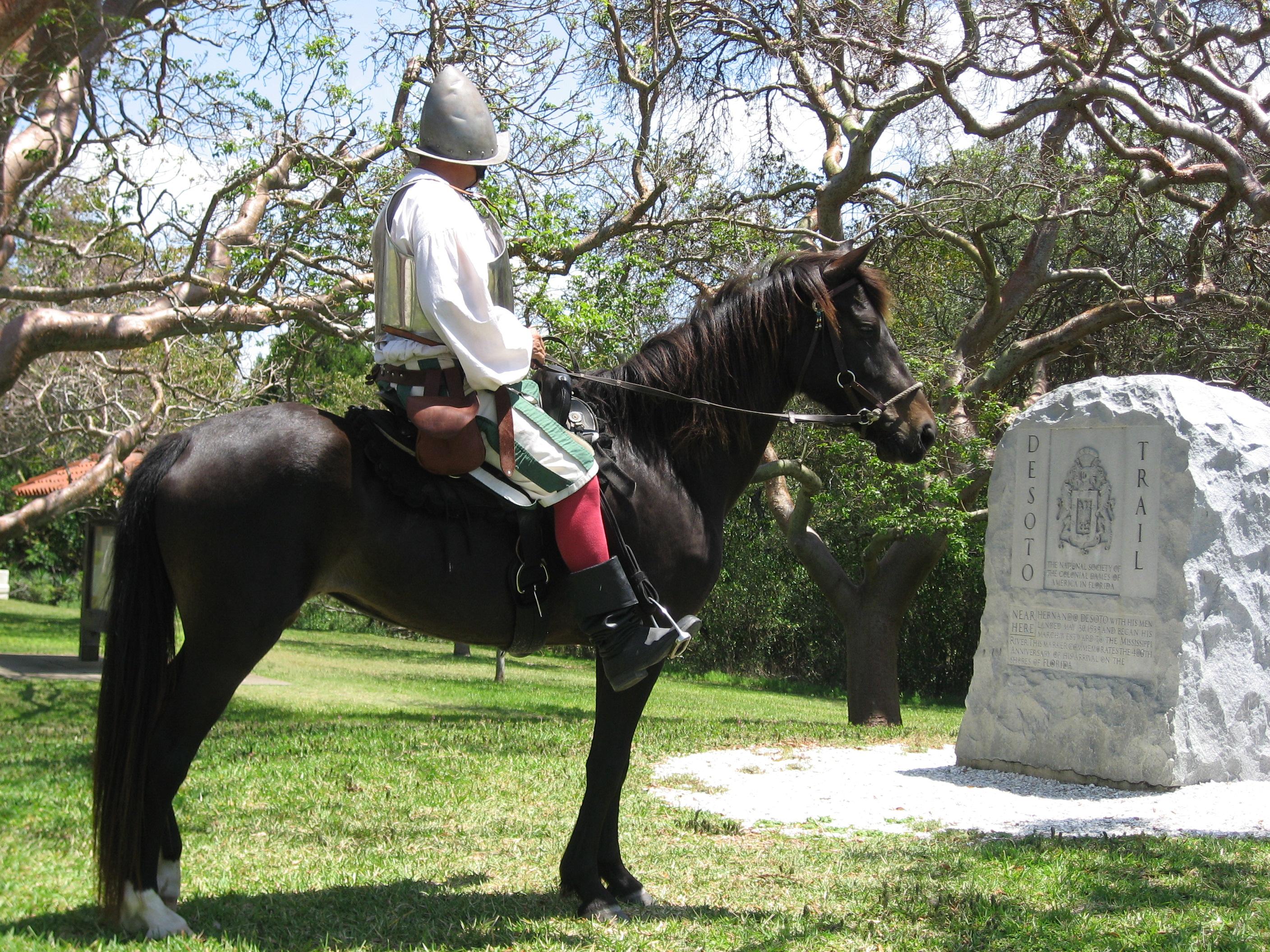
De Soto National Memorial
National Memorial
In May 1539, Conquistador Hernando de Soto’s army of soldiers, hired mercenaries, craftsmen, and clergy made landfall in Tampa Bay. They were met with fierce resistance of indigenous people protecting...
7 mi from route
~17 min detour
Free
near mile 36.5
Park data from the National Park Service API. Alerts update every 2 hours.
More Details
What kind of drive is this?
This trip is defined by its efficiency, with 91% of the distance spent on high-speed highways. You will navigate the Sunshine Skyway Bridge as part of your transition onto I-275, which serves as a notable transition point early in your journey. Once you merge onto I-75, prepare for a long, consistent haul; you will remain on this interstate for a single, uninterrupted stretch of 209.3 miles. Because of this heavy reliance on major thoroughfares, the drive feels like a steady, focused interstate grind rather than a winding scenic tour. Expect a fast-paced environment where the personality of the road remains largely consistent throughout the majority of your time behind the wheel.
91% highway — fuel and pacing are the main things to plan.
34 navigation steps total — most of the decisions cluster near the start and finish.
Longest single stretch: 209.3 mi on I 75.
How Hard Is This Drive?
9/10
This is a straightforward highway drive that stays mostly on I 75 and Sunshine Skyway Bridge. This route has several spots where lane changes, forks, or exits need your full attention. The trickiest moment comes around 248.7 miles in near I 595 / Port Everglades Expressway.
Driving Effort9/10
High effort - long or complex enough to need steady focus all day
Balances navigation complexity with total wheel time.
This is a demanding drive. With 28 significant decision points across 264.9 miles, you will need to stay alert - especially through interchange areas and urban stretches. Consider splitting it into segments if you are not comfortable with fast highway navigation.
Where does it get tricky?
The main spots that need attention: at 248.7 miles (I 595 / Port Everglades Expressway): Highway fork - watch signs carefully. Lane positioning matters here. Multiple destination signs - pick the right one; at 257.7 miles: Exit ramp - move to the correct lane early. Lane positioning matters here. Multiple destination signs - pick the right one; at 258.3 miles: Lane positioning matters here. Multiple destination signs - pick the right one.
Elevation Profile
Mostly flat terrain
65 ft6 ft
Total Climb
28 ft
Total Descent
70 ft
Highest Point
65 ft
~18.9 mi in
Elevation Range
59 ft
Towns Mentioned on Route Signs
Based on OSRM destination-sign hints, not a full list of every settlement the road passes.
On the drive from Belleair, FL to Pembroke Pines, FL, road signs begin pointing toward Fort Lauderdale along the way.
Doable as a same-day drive at 5h 2m. Total distance: 264.9 miles.
Family Friendly
Moderate complexity with 1 natural rest stops along the way.
Solo Traveler
5h 2m drive, comfortable solo distance.
First-Time Driver
Mostly highway driving (91%). Some complex stretches to watch for.
Frequently Asked Questions
The longest stretch is about 209.3 miles on I 75. The full list of main roads is in the Roads section above.
Expect about $1.24 in tolls one way, starting with Sunshine Skyway Bridge. Most Northeast and Midwest toll agencies accept E-ZPass; in the West and Texas, transponders like TxTag or FasTrak apply. If you do not have a transponder, cashless tolling plates will mail a bill to the vehicle's registered address — usually with a surcharge, so a rental-car toll pass is often cheaper than paying by mail.
We did not find dedicated rest areas on this route. For a drive this long, plan bathroom and stretch breaks around gas stations, fast-food stops, or small-town downtowns — check the Nearby Places section for options.
It helps. This route has a higher-than-average number of complex decision points, which get harder in the dark. If the last hour of the trip is on surface roads or mountain grades, aim to arrive at Pembroke Pines, FL before sunset when you can. Check the Trip Plan for departure windows that land you in daylight.
Only with planning. This is a long drive for kids — consider splitting it into two days rather than pushing through. Plan at least 1 meaningful breaks. Dedicated rest areas are limited, so plan gas or food stops as your bathroom breaks.
The main spots that need attention: at 248.7 miles (I 595 / Port Everglades Expressway): Highway fork - watch signs carefully. Lane positioning matters here. Multiple destination signs - pick the right one; at 257.7 miles: Exit ramp - move to the correct lane early. Lane positioning matters here. Multiple destination signs - pick the right one; at 258.3 miles: Lane positioning matters here. Multiple destination signs - pick the right one.
Yes — De Soto National Memorial. See the National Parks section for detour distances and tips on detours.
Not recommended in a single day. At 5.0 hours each way, a round trip means 10.1 hours of driving — that is an unsafe level of fatigue for most drivers. Plan at least one night at Pembroke Pines, FL before the return drive.