Origin
Arvada, CO
Late night in Arvada on Tuesday
Local time
2:14 AM
MDT
Current temp
35°F
Unavailable
Live forecast
Compiled and reviewed by the US Trip Planner planning team at COD Solutions Oy · Last reviewed Apr 21, 2026 · Editorial standards
Drive Time
1h 31m
Distance
74.8 mi
120 km
Drive Score
7/10
Good drive
Same Day?
Yes, doable
Fuel Cost
$11
one way
EV Charging
Unknown
Estimated drive times based on typical traffic patterns. Actual times may vary with weather, construction, and real-time conditions.

Arvada, CO
Wikimedia Commons

Black Forest, CO
Justin Wolfert
Arvada, CO to Black Forest, CO is 74.8 miles and takes about 1h 31m via North Valley Highway and I 70, with a fuel budget near $11 and enough daylight to finish in a day. This drive stays within the Mountain West region, connecting two points in Colorado. Expect a local feel with plenty of turns, making it more of an engaging local road trip than a long-haul journey. Given its short duration, it’s an ideal same-day excursion.
Trip Pace
Same-day drive is realistic
A same-day return is realistic if you keep stops short.
Midpoint
37.4 miles from Arvada, CO
A natural place for your longest stop of the day , about 45m into the drive .
| Road | Distance | Duration |
|---|---|---|
| North Valley Highway | 59.8 mi | 1h 5m |
| Shoup Road | 4.3 mi | 7m |
| I 70 | 3 mi | 4m |
| Interquest Parkway | 2.8 mi | 4m |
| Ralston Road | 1.8 mi | 3m |
| Sheridan Boulevard | 1.1 mi | 2m |
| Grand Army of the Republic Highway | 0.2 mi | <1m |
| Allison Street | <0.1 mi | <1m |
Step-by-step road directions between Arvada, CO and Black Forest, CO.
Start on this road
Turn right onto Ammons Street
Turn left
At end of road, turn right onto Allison Street
Turn left onto Ralston Road
Turn right onto CO 95
Take the ramp
Merge onto I 70
Take the exit
Keep slight right at fork
Keep slight right at fork
Merge onto Grand Army of the Republic Highway
Keep slight left at fork
Merge onto I 25
Take the exit
Continue on Interquest Parkway
Turn right onto Shoup Road
Turn left onto CR 189
Arrive at destination
Since this is a short, roughly 1.5-hour drive, you have the flexibility to depart at your convenience. With a fuel cost estimated at $11, you won't need extensive planning for gas stops. Pay close attention to the 'turn-heavy' nature of this route; relying solely on GPS without being aware of upcoming turns could lead to missed exits. The longest stretch is on North Valley Highway, so plan your focus accordingly during that segment.
Morning Departure
Leave by 9 AM and you'll arrive before lunch.
Evening Departure
Even a 4 PM departure gets you there before dark in summer.
This is a comfortable same-day trip.
Departure
Before you leave
Start with fuel, water, and navigation already sorted so the first hour feels easy.
First stop
Around 16 miles or 22m in
Use this first pause for coffee, a restroom break, and a quick traffic check ahead.
Halfway reset
Around 37.4 miles or 45m in
This is the best place for your longest stop, a real meal, and a full fuel check.
Final approach
Final hour starts around 1h 14m
Traffic, exits, and arrival timing usually matter more near Black Forest, CO than in the middle of the route.
Open the route before leaving Arvada, CO so your first major turns are already loaded.
Day 1
Settle into the route from Arvada, CO
This is one driving day of about 74.8 miles and 1h 31m.
Rest stops, refuel points, and overnight suggestions along this route.

Mid-route town
Meal stop
37 mi into the route
Best for: Lunch, fuel, and a longer reset
This sits close to the middle of the route, so it works well for the longest stop of the day.
A short stop after about 16 miles helps settle the day before fatigue starts building.
The midpoint is around 37.4 miles from Arvada, CO, which is a good place for a longer meal and fuel stop.
These stop ideas are pacing suggestions — the exact town or exit can change with traffic, hotel plans, and fuel range.
5 decision points cluster between mile 0.1 and 67.1 — GPS handles the exact turns, but know they're coming. Your lane choice matters more than the turn itself.
At end of road, turn right onto Allison Street
Complex interchange - multiple decisions in a short stretch
Take the exit toward I 25: Fort Collins, Colorado Springs
Exit ramp - move to the correct lane early. Lane positioning matters here. Multiple destination signs - pick the right one
Keep slight right at fork toward I 25 South: Washington Street, Colorado Springs
Highway fork - watch signs carefully. Lane positioning matters here. Multiple destination signs - pick the right one
Keep slight right at fork toward I 25 South: Colorado Springs
Highway fork - watch signs carefully. Lane positioning matters here
Take the exit toward Interquest Parkway
Exit ramp - move to the correct lane early. Lane positioning matters here
Regular Gas
$11.27 one way
$22.54 round trip
| Fuel Type | $/gal | One Way | Round Trip |
|---|---|---|---|
| midgrade | $4.05 | $11.93 | $23.87 |
| premium | $4.39 | $12.94 | $25.88 |
| diesel | $5.61 | $16.51 | $33.03 |
No toll roads detected on this route.
Estimated Trip Cost (one way, 1 person)
Fuel
$11
Meals
$25–$50
Total
$36–$61
Rough estimate based on US averages. Hotel $80–$140/night, meals $25–$50/day.
Estimated CO2 emission: 26.2 kg one way. Prices: EIA weekly data, 2026-04-13.
Driving Electric?
About $8 in charging · 0 stops · 65% less CO2
| Vehicle Type | kWh | Stops | DC Fast | Home Charge |
|---|---|---|---|---|
| Average EV | 22.4 | 0 | $7.85 | $3.59 |
| Efficient EV | 18.7 | 0 | $6.54 | $2.99 |
| EV Truck/SUV | 29.9 | 0 | $10.47 | $4.79 |
Gas CO2
26 kg
EV CO2
9 kg (65% less)
This trip is well within single-charge range for most EVs. No charging stops needed if you start fully charged.
DC fast charging avg $0.35/kWh. Home charging avg $0.16/kWh. US grid CO2: 0.39 kg/kWh.
Current conditions at both ends of the drive.
Origin
Late night in Arvada on Tuesday
Local time
2:14 AM
MDT
Current temp
35°F
Unavailable
Destination
Late night in Black Forest on Tuesday
Local time
2:14 AM
MDT
Current temp
31°F
Unavailable
Seasonal Notes
Summer travel usually means heavier construction, hotter rest stops, and busier weekend traffic around major cities.
Winter travel shortens daylight, so a route that looks manageable on paper can feel much longer after dark.
Holiday weekends tend to make both departure and arrival windows slower than the raw route time suggests.
Time zone
Origin and destination are on the same clock, so arrival timing is easier to judge at a glance.
Temperature spread
A meaningful temperature swing is a good cue to rethink layers, water, and how soon you want to arrive.
Road read
Use the two city cards together: check the sky where you start, then compare it with the local time and temperature at arrival.
Weather data from the National Weather Service. Conditions may change; check closer to your travel date.
Worth a detour if your schedule allows.
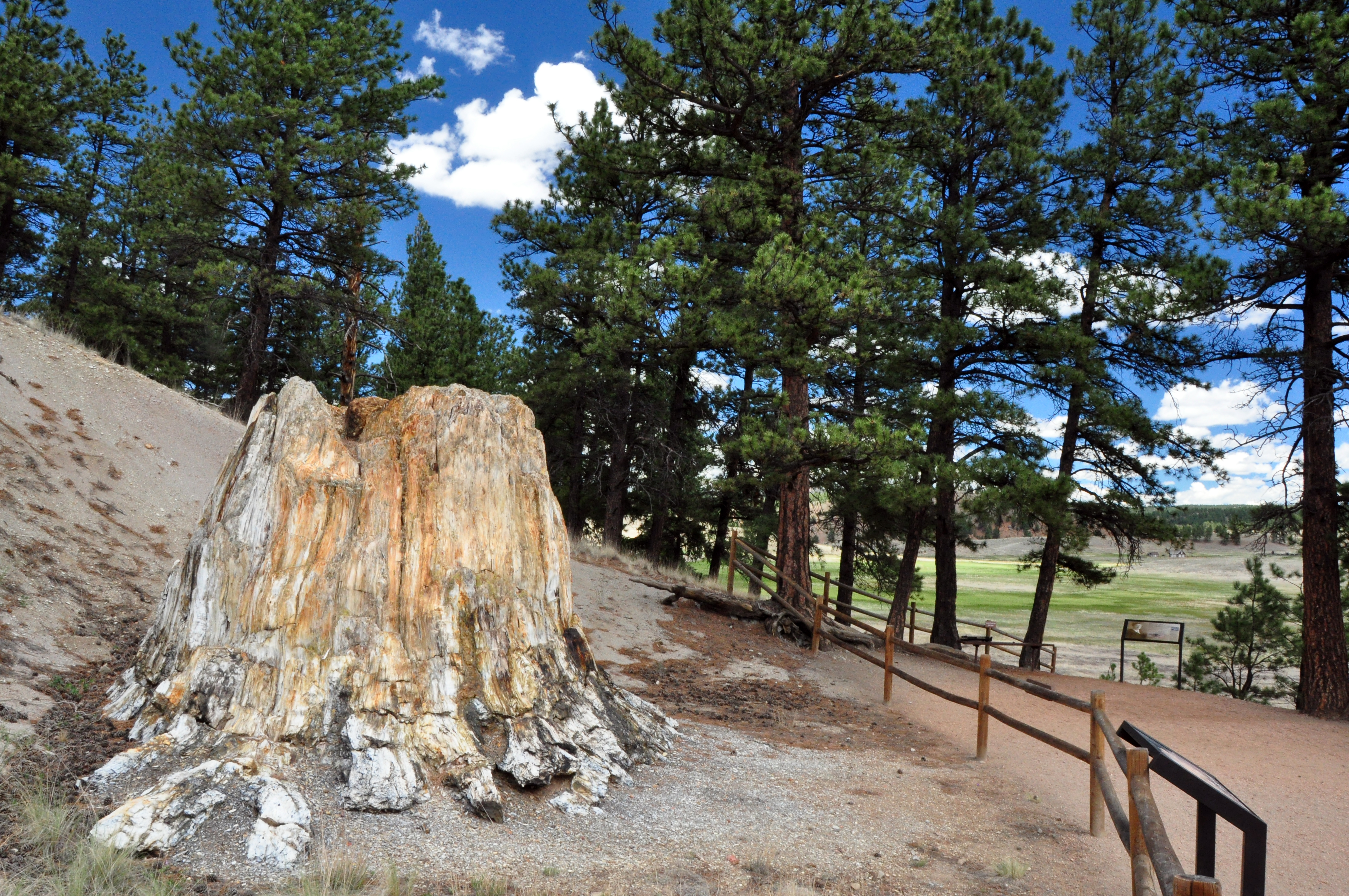
National Monument
Beneath a grassy mountain valley in central Colorado lies one of the richest and most diverse fossil deposits in the world. Petrified redwood stumps up to 14 feet wide and thousands of detailed fossil...
Park data from the National Park Service API. Alerts update every 2 hours.
This route is characterized as a 'turn-heavy local drive,' with only an 8% share on highways like I 70. You'll experience a mix of local roads, including Shoup Road, with the longest uninterrupted stretch spanning 59.8 miles on North Valley Highway. This suggests a drive that requires your attention, with frequent adjustments in direction rather than a steady, high-speed cruise. The profile indicates a drive that winds through local landscapes, demanding active navigation.
Expect a hands-on drive with frequent turns and local roads rather than long highway stretches. This route has several spots where lane changes, forks, or exits need your full attention. The trickiest moment comes around 0.1 miles in near Allison Street.
Demanding - stay alert through the decision-heavy sections
Balances navigation complexity with total wheel time.
This drive requires moderate attention. Across 74.8 miles you will encounter 15 spots where lane choice or exit timing matters. Not difficult for experienced highway drivers, but worth previewing the tricky sections before you go.
Where does it get tricky?
The main spots that need attention: at 0.1 miles (Allison Street): Complex interchange - multiple decisions in a short stretch; at 6.3 miles: Exit ramp - move to the correct lane early. Lane positioning matters here. Multiple destination signs - pick the right one; at 6.5 miles: Highway fork - watch signs carefully. Lane positioning matters here. Multiple destination signs - pick the right one.
Based on OSRM destination-sign hints, not a full list of every settlement the road passes.
On the drive from Arvada, CO to Black Forest, CO, road signs begin pointing toward Colorado Springs along the way.
Colorado Springs
Founded 1859
Arvada is a city of about 125,000 in the Denver Metropolitan Area of the U.S. state of Colorado. A former farming community in Jefferson and Adams counties, the city is now a residential suburb of Denver. Olde Town Arvada lies 7 miles (11 km) northwest of the Colorado State Capitol and 9 miles (14 km) east of the Front Range foothills.
Top landmarks
City content from Wikivoyage (CC BY-SA 4.0) and Wikidata (CC0).
Weekend Trip
Doable as a same-day drive at 1h 31m. Total distance: 74.8 miles.
Family Friendly
Moderate complexity with 0 natural rest stops along the way.
Solo Traveler
1h 31m drive, comfortable solo distance.
Scenic Drive
Mostly surface roads route profile with national parks nearby.
Compiled by the US Trip Planner planning team at COD Solutions Oy from open government datasets — OSRM over OpenStreetMap for geometry, EIA for fuel prices, and NPS for national parks. See our methodology for refresh cadence and limitations.
Was this helpful?
Thanks for your feedback!
Your tip has been submitted. Thanks!
/500
Recent Tips
·
Explore more options from Arvada, CO or browse trips ending in Black Forest, CO.
Looking for more statewide routes? Browse CO road trips.